Contents
- Introduction
- The case for East West Rail
- Route map
- Our proposals for East West Rail (EWR)
- Our consultations and the planning process
- How to respond to this consultation
- Our approach to good design
- Door-to-door connectivity, including active travel
- Our approach to the environment
- Our approach to traffic and construction
- Route-wide matters
- Oxford to Bletchley
- Fenny Stratford to Kempston
- Bedford
- Clapham Green to Colesden
- Roxton to east of St Neots
- Croxton to Toft
- Comberton to Shelford
- Cambridge
- List of consultation materials
- Our consultation events
- Avoiding and managing potential construction impacts
- Glossary and abbreviations
Consultation 2026
A complete guide to all the key information for this consultation
Foreword
East West Rail (EWR) is about far more than building a railway. At its heart, this project is about people and the long‑term potential of the communities it will serve, today and for generations to come. By connecting people and places between Oxford, Milton Keynes, Bedford and Cambridge, EWR can support sustainable growth across the entire region: enabling new homes where they’re needed most, strengthening employment and education opportunities, and making everyday journeys easier – whether for work, essential services or simply seeing friends and family. A reliable rail link would also ease pressure on local roads and support a greener, more resilient future for the region.
Across our three consultations in 2019, 2021 and 2024, thousands of people have taken the time to share their views. These insights have played a key role in shaping our proposals. Following feedback from the 2024 consultation alone, we made more than 80 design improvements to make sure EWR continues to reflect local priorities. During the 2024 consultation, I was pleased to see a record turnout at events and meet so many people in person. These conversations help us understand local perspectives – what matters most to communities, and where we can offer clearer information or address concerns.
With key decisions now confirmed, this consultation marks an important milestone as we move towards finalising our designs. It sets out our latest proposals – which include new and updated features – and provides the opportunity for people to help shape the final refinements before we submit our designs to the Secretary of State for a Development Consent Order (DCO) application.
Your feedback is crucial and every formal response to our latest proposals will be taken into account.
I strongly encourage you to share your views formally, and the ways to respond are outlined on page 31. Your feedback will inform our final designs to ensure the railway best serves local communities – creating a better‑connected future for generations to come.
1. Introduction
This brochure outlines our latest proposals for East West Rail (EWR).
We’ve updated proposals to take account of:
-
Further design work
-
Ongoing engagement
-
Environmental assessments
-
Traffic and transport analysis
-
Feedback from our previous consultation
This consultation will run for eight weeks from 14 April to 9 June 2026. The purpose is to gather feedback on updated proposals, particularly on elements which are new or have changed significantly since our previous consultation.
This brochure contains:
-
Background information on EWR, the planning process, how to respond to this consultation and next steps
-
Information about:
-
Our design principles and how we’re applying them
-
Our approach to door‑to‑door connectivity
-
Our approach to the environment
-
Our approach to traffic and construction
-
Route‑wide matters including electrification, depots and utilities
-
An overview of our designs for each route section, including details of the new and updated proposals on which we would like your feedback
To help bring the project to life, we’ve produced maps, plans, illustrations and visualisations showing the route of the proposed railway and its key features. The plans also identify proposals for mitigation and enhancement as well as showing the land that would be required for the railway, both temporarily and permanently.
We’re asking for your feedback, especially from people living and working in local communities, and those whose homes or properties could be affected by the proposals.
We will take account of the feedback from this consultation, ongoing engagement and the outputs of environmental and transport assessments, before we finalise proposals for the railway and submit a Development Consent Order (DCO) application.
Everyone is encouraged to take part, and we look forward to receiving your comments.
2. The case for East West Rail
People living and working in communities along the route will experience the benefits of East West Rail (EWR) in many different ways. From stronger local economies to easier everyday journeys and more connected places, the strategic aims of the project could help address long‑standing challenges and support a better future for the region.
In short, EWR would:
-
Connect communities with better east‑west rail links, improving journey times and convenience compared to travelling by road
-
Strengthen links with existing north‑south routes across the national rail network, opening up the wider UK transport network
-
Expand access to jobs and skills, allowing businesses to recruit from a wider labour market and creating more employment opportunities
-
Support investment and economic growth in both the region and on a national scale
-
Enable new homes and growing towns to be well‑connected with modern transport connections
-
Offer a sustainable alternative to road travel, allowing people to make better transport choices
-
Take lorries off local roads by supporting rail freight as an essential part of the UK’s supply chain
Unlocking the region
The area between Oxford and Cambridge is one of the UK’s strongest economic assets – attracting investment, driving economic growth and delivering world‑leading innovation. The region has consistently proven to be a source of economic resilience and contributes over £143 billion to the national economy every year, supporting around two million jobs. A third of these are in knowledge‑intensive sectors – three times the national average.
The Universities of Oxford and Cambridge underpin this success. Around them, a diverse innovation ecosystem has grown – including Europe’s largest technology cluster in Cambridge and major research centres such as Harwell Campus – home to the UK’s Space Gateway. The region brings together leading research, commercial scale, strong entrepreneurial activity and established freight and distribution networks. Very few places in Europe match this concentration of talent, investment and innovation.
Yet the region’s transport network doesn’t match its economic strength. Limited east–west connectivity is creating barriers for people and businesses, holding back growth and making it harder to compete internationally. Journeys in between these important economic centres take longer than they should, reducing the region’s potential; many people rely on indirect rail journeys via London or heavily congested roads such as the A34, A421 and A428. Despite having a labour pool that could be comparable to some of the world’s leading innovation regions, it remains disconnected. This separation between people and jobs discourages investment, increases costs and makes it harder for businesses to operate. Ultimately, it’s holding the region back at a time when global competition is intensifying.
East West Rail (EWR) would help to unlock the region by creating a direct east–west rail connection. This would bring Oxford, Milton Keynes, Bedford and Cambridge closer together as a more integrated economic area – helping to build the critical mass the UK needs to compete globally. It would offer quicker and more convenient journeys that connect people with jobs, education and essential services, supporting a more accessible and better‑connected future for the region.
The Business Case for EWR is being developed in accordance with Treasury and Department for Transport guidance. However, you can find more information on why EWR is the key to unlocking growth at eastwestrail.co.uk/caseforewr
“East West Rail will unlock growth and productivity and benefit communities right across the Oxford‑Cambridge corridor. It will create faster, more direct rail connections and improve access to employment, training, and education.
East West Rail is a central part of the government’s plans for growth in the region and has the potential to support up to 100,000 new homes, providing well‑connected, sustainable communities. By 2050, East West Rail is set to boost the regional economies of the counties between Oxford‑Cambridge by £6.7 billion every year.”
‑ Heidi Alexander, Secretary of State for Transport (19 November 2025)
3. Route map
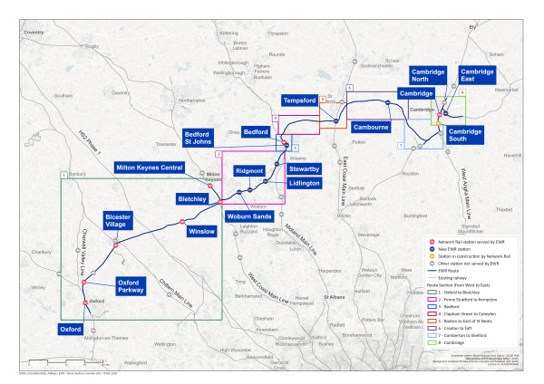
Figure 1: Map of the planned EWR route divided into eight route sections
4. Our proposals for East West Rail (EWR)
EWR is a nationally significant railway project that aims to provide much‑needed transport connections for communities between Oxford, Milton Keynes, Bedford and Cambridge.
Between Bedford and Cambridge, we’re proposing a new railway. Between Oxford and Bedford and to the east of Cambridge, we’re proposing associated works to upgrade the existing railway. Together, these elements are referred to as ‘the project’.
The project involves the following key aspects:
-
New railway and new stations
-
Construction of a new railway between Bedford and Cambridge
-
Construction of new stations at Tempsford, Cambourne and Cambridge East
-
Upgrading the existing railway
-
Improvements to the railway between Oxford and Bedford
-
Improvements to the railway on the approach into Cambridge, and on the Newmarket Line between Cambridge and Fulbourn
-
Station upgrades and relocations
-
Remodelling Bedford station
-
Consolidating stations on the Marston Vale Line into four new stations at:
-
Woburn Sands
-
Ridgmont
-
Lidlington
-
Stewartby
-
Decommissioning of underused stations
-
Relocating Bedford St Johns station
-
Improvements at Cambridge station, including construction of a new eastern entrance
-
Improvements at Bletchley station, including construction of a new eastern entrance
-
Upgrading existing stations across the route to accommodate increased passenger numbers
-
Active travel measures to enable easy access to stations and to maintain connectivity between communities
-
New railway infrastructure
-
Construction of infrastructure such as depots, viaducts, tunnels, bridges, cuttings and embankments
-
Construction of new passing loops
-
Level crossings
-
Improvements to, or closure of, existing level crossings, with appropriate replacement crossings where needed
-
Electrification and power
-
Works to enable discontinuous electrification, including overhead line equipment, substations and grid connections
-
Interfaces with roads, rights of way and utilities
-
Works to manage interfaces between the railway and highways, public rights of way, watercourses and utilities
-
Environment and biodiversity
-
Measures to reduce environmental impacts and deliver biodiversity net gain, including habitat creation, landscape enhancement and nature recovery initiatives
Some elements of the project are reliant on third‑party funding. Where this is the case, this is stated within the route section chapters of this brochure.
How we will deliver East West Rail
We’ve always planned for EWR to be built in stages to better connect the region as soon as possible. Now, we’re accelerating parts of the programme so that communities can experience the benefits even sooner.
This approach is intended to unlock opportunities for new homes and attract investment and business growth. The accelerated delivery would also provide higher capacity and more frequent services to the new Universal Entertainment Resort Complex as soon as the necessary works are completed.
By 2030
Following entry into service of trains between Oxford and Milton Keynes, we would start construction of a new station at Tempsford, with platforms on the East Coast Main Line, to serve the proposed new town with north‑south train links. This would provide connectivity to Tempsford earlier than originally planned. EWR platforms would follow in the mid to late 2030s. We would support increased train capacity from the west to Milton Keynes, where Universal plan to run a coach shuttle service to the new resort when it opens.
By the early 2030s
We would upgrade and electrify the Marston Vale Line (MVL) meaning we could introduce four trains per hour between Oxford and Stewartby. We would construct four modern, fully accessible stations, including a new station at Stewartby to serve the Universal Entertainment Resort Complex and improve Bletchley station. Accelerating this part of the programme means train services would be starting within the first few years of the park opening, in line with expected increase in demand.
By the mid-2030s
We would accelerate the construction of an upgraded station in Bedford, delivering modern facilities and improved connections for both north‑south and east‑west train services. Once complete, up to four trains per hour would serve Bedford from the west.
We would provide a new entrance at Cambridge station and deliver early connectivity improvements for passengers ahead of the introduction of EWR services. We would also complete the new station at Cambridge East (subject to third‑party funding), enabling other services to use the station before EWR services start.
By the mid to late 2030s
We plan to open the full railway by the mid‑to‑late 2030s. By this time the new section of railway between Bedford and Cambridge would have been completed, and all new stations would have been opened. We anticipate EWR services would be running the full train services as outlined below.
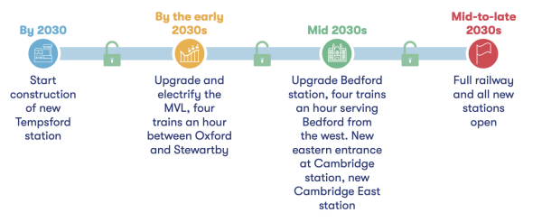
Figure 2: Benefits of a phased delivery approach
Train services
Since our previous consultation, we’ve updated our proposed train service specification, meaning that there would be more frequent East West Rail (EWR) services for local communities.
As outlined in our You Said, We Did Autumn Update, new developments, including the approved Universal Entertainment Resort Complex near Bedford, mean that we expect more people to use EWR. That’s why we’ve increased the planned service levels to accommodate this additional demand.
Previously, we proposed:
- Two trains per hour in each direction between Oxford and Bletchley
- Two trains per hour from Oxford to Milton Keynes via Bletchley
- Three trains per hour in each direction between Bletchley and Bedford
- Four trains per hour in each direction between Bedford and Cambridge
We’re now proposing a core EWR service of four trains per hour across the whole route, with a possible additional fifth train per hour operating during the busiest hours – or potentially over a longer period if required. This additional train could also be used to enable service extensions to and from locations on the wider rail network beyond the EWR route.
To support the increased demand, we’re also considering operating longer trains of up to five carriages.
The proposed EWR services are:
- Two Oxford‑Milton Keynes services per hour in each direction
- Two Oxford‑Cambridge East services per hour in each direction
- Two Bletchley‑Cambridge services per hour in each direction
- One additional service, which could support potential service extensions beyond the EWR route
The proposed train service is illustrated below:
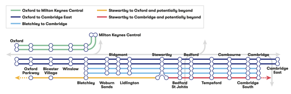
Figure 3: EWR train service specification for passenger trains
We’ve also made provision for one freight path per hour in each direction across the EWR route. We anticipate that freight service levels would follow the pattern described below, but only if no additional limitations arise elsewhere on the rail network. If wider network constraints are not addressed by other projects, they could restrict the level of freight services that could realistically be delivered:
-
Up to one freight train per hour in each direction between Oxford and Bletchley
-
Up to one freight train every two hours in each direction between Bletchley and Bedford
-
Around two freight trains in each direction each day east of Bedford
These paths would enable freight services that use parts of the route today to continue to operate.
Our consultation and the planning process
Previous consultations
Since 2019, we’ve carried out three consultations, to gather feedback and to share updates on progress as proposals have developed for East West Rail (EWR).
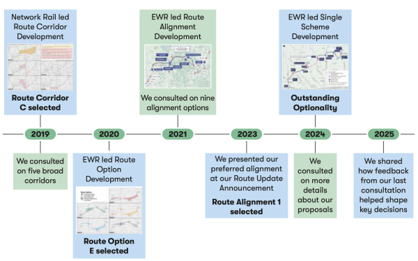
Figure 4: Timeline of previous consultations and major announcements
Our 2019 consultation
In 2019, we consulted on five areas through which the railway could run. Feedback was received on all options and in January 2020 Route Option E was confirmed as the preferred option. This route links existing stations in Bedford and Cambridge with communities in Cambourne and the area north of Sandy, south of St Neots.
Our 2021 consultation
In 2021, we consulted on nine route alignment options for the railway between Bedford and Cambridge and on other aspects of the project between Oxford and Cambridge. The alignments presented were within the area identified for Preferred Route Option E, as well as possible route alignments partially outside that area, recognising the potential to serve a station north of Cambourne and/or to follow the route of National Highways’ A428 Black Cat to Caxton Gibbet improvement scheme.
Following the 2021 consultation, we were asked by the government to review the strategic case for EWR and explore ways to lower the cost. We carried out this review while considering feedback from our 2021 consultation. In the route update announcement in May 2023, we confirmed our preference for Alignment 1, which passes north of Ravensden, Wilden and Roxton. We also identified our preference for a local variation of the alignment to provide a new station at Tempsford rather than St Neots south.
Our 2024 consultation
In 2024, we carried out a further consultation across all eight route sections forming Alignment 1, to obtain feedback on design elements for which we were considering more than one option. We also invited feedback on topics such as land and property, environment and sustainability, traffic and transport, construction and logistics, and active travel and community benefits.
Progress since our 2024 consultation
Since our previous consultation, we’ve carried out a range of activities to further develop our plans, including:
-
Carefully considering all comments received
-
Undertaking further studies and surveys – for example, assessing traffic and environmental impacts
-
Continuing engagement with affected parties and statutory bodies, such as local councils and public service providers
We published a consultation update in May 2025, providing an overview of how the 2024 consultation was delivered and highlighting emerging findings.
In November 2025, we then published:
-
You Said, We Did Autumn Update (eastwestrail.co.uk/you-said-we-did/you-said-we-did-report), outlining progress made – including key decisions and changes under consideration, prompted by feedback received, wider technical work and other developments
-
Feedback Summary Report (eastwestrail.co.uk/you-said-we-did/feedback-summary-report), summarising the feedback received
Current stage and next steps
We’re holding this consultation to ask for your views on updated proposals, particularly on elements which are new or have changed significantly since our previous consultation. This consultation is intended to be our final consultation before we submit our Development Consent Order (DCO) application. It is important that you’re involved in our consultation process as this gives you the opportunity to influence designs and help the project to address local needs and priorities.
The DCO Process
The proposed new section of railway between Bedford and Cambridge has been designated as a project of national significance. We’re required to apply to the Secretary of State for Transport for a DCO. This would give us permission to build the new railway between Bedford and Cambridge, and provide the additional upgrades between Oxford and Bedford, and around Cambridge.
The DCO process is governed by the Planning Act 2008. The figure below shows where we are in relation to the six stages of the DCO process.
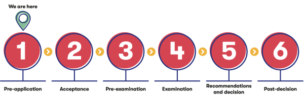
Figure 5: Overview of the six stages of the Development Consent Order process
We’re currently in the pre-application stage of the project. This means we’re continuing to consult and engage with people who live, work, and travel in the areas along the route, as well as with local councils and other stakeholders.
Changes to the Planning Act 2008 via the Planning and Infrastructure Act 2025 will update the DCO process to make it simpler and more efficient. One of those changes is the removal of statutory pre‑application consultation requirements, which we understand will be implemented this summer.
While there will no longer be a statutory requirement to conduct a pre‑application consultation, we think it’s important to still run this routewide consultation to make sure people have the opportunity to review our updated proposals and share feedback before we submit our DCO application. This will help to narrow and address any issues likely to arise.
The amended pre‑application procedure in the Planning Act 2008 will also give us more flexibility in how we engage with communities. As our designs develop, it allows us to focus more on local issues and provide more targeted engagement with the people and organisations most affected.
After this consultation, we’ll finalise our proposals and submit our DCO application to the Planning Inspectorate. If the application is accepted, it will be published and people will be able to register to take part to take part in the examination. The Planning Inspectorate will appoint a panel of independent inspectors – known as the Examining Authority ‑ to examine the application. The examination can take up to six months and involves submitting written comments and speaking at hearings. The Examining Authority will then make a recommendation to the Secretary of State, who will decide whether to grant development consent.
If you’d like to know more, information about the DCO process is available at: infrastructure.planninginspectorate.gov.uk/application-process/the-process
How to respond to this consultation
This is your opportunity to tell us what you think about our proposals, especially the parts that are new or have changed significantly since the previous consultation. A high‑level summary of these is set out below, with more detail in the relevant route chapters.
In the Oxford to Bletchley chapter, our updated proposals include:
-
An underpass at London Road, Bicester
-
A Bletchley West train maintenance depot and passing loops
-
An eastern entrance for Bletchley station
In the Fenny Stratford to Kempston chapter, our updated proposals include:
-
Four new stations, including walking, cycling, equestrian and wheeling links to local communities
-
The seven level crossings where our proposals have changed
In the Bedford chapter, our updated proposals include:
-
A realigned track curve south of Bedford St Johns station
-
A revised Bedford St Johns station design and multi‑storey car park
-
A remodelled Bedford station, including a new civic plaza, western entrance, a new platform for fast trains to London, and a new location for the multi‑ storey car park
In the Croxton to Toft chapter, our updated proposals include:
-
A new station at Cambourne, 700 metres west of the location proposed at our previous consultation
In the Cambridge chapter, our updated proposals include:
-
A new eastern entrance for Cambridge station
-
A new Cambridge East station
-
A new Cambridge Eastern train care centre
You can respond to the consultation by:
-
Completing the consultation feedback form online at eastwestrail.co.uk/feedback
-
Emailing a copy of the feedback form to [email protected] • Sending a copy of the feedback form to Freepost EAST WEST RAIL
-
Handing in a copy of the feedback form at a consultation event (You can find the full list of consultation events in Chapter 20 of this brochure)
For further information or to request a paper copy of the feedback form to be sent to you, get in touch at [email protected] or by calling us on 0330 134 0067.
Please make sure you share your feedback with us by 23:59 on 9 June 2026.
Accessibility
We want as many people as possible to take part in this consultation. It’s important that everyone living in the communities East West Rail would serve can share their views. That’s why key materials are available in accessible formats.
If you, or someone you know, would like the consultation materials in a different format or language, please email [email protected] or call 0330 134 0067.
Data Protection
All personal information received as part of this consultation will be handled in accordance with our privacy policy which can be found at eastwestrail.co.uk/privacy-at-ewr-co
Copies of consultation responses may be requested by the Planning Inspectorate or the Examining Authority after we submit the DCO application.
If you give us personal information about other people, you must first make sure that you have obtained all necessary permission from that person for you to pass this information on to us.
Find out more
You can find the full range of consultation material in accessible and downloadable formats on our project website together with information on how you can respond to this consultation and further details about East West Rail.
Our commitment to land and property owners
We will need land to build, operate and maintain the railway. We’ll also need land to divert impacted utilities, such as power lines and water pipes, and to provide environmental compensation to offset impacts of the railway. This includes measures such as planting trees or providing areas of replacement habitat for protected species. All the land we need to build, operate and offset the impacts of the project is included within our draft Order Limits. The draft Order Limits are shown on plans as part of this consultation and has been updated from what we shared at our consultation in 2024. These updates reflect changes we have made following further refinement of our design and in response to feedback from landowners and other interested parties.
As part of this consultation, we have published Land Use plans which show how we would need to use the land within the draft Order Limits to construct and operate EWR. The plans show the draft Order Limits and shading to illustrate the land that will need to be acquired permanently for the railway and associated infrastructure. They also identify the land we would need to use temporarily (e.g. for construction compounds) and land over which we would need to acquire rights (e.g. to divert utilities apparatus).
The draft Order Limits may change in the future to respond to consultation and engagement feedback and further design development, for example for new or altered utilities infrastructure. We will continue to engage with any affected parties as we refine our proposals.
We understand that our proposals will have an impact on land and property owners, including local residents and businesses, where there’s a possibility of land or property being required by EWR. We want to work closely with those potentially affected, take the time to understand their circumstances, and provide clear information and support throughout the project.
We have allocated case managers to land and property owners to ensure those affected by our plans know who to reach out to with their concerns and questions. Each case manager is building relationships with them as part of an ongoing engagement programme.
We’re also keeping our land ownership records updated using HM Land Registry data, land interest questionnaires, landowner meetings and site visits. This is an essential part of the project development process for projects like EWR, as this helps to identify who owns, occupies and uses land that may be affected by the railway – and it means we can keep people fully informed about our proposals and the planning process.
The Secretary of State for Transport has previously issued safeguarding directions for EWR, and the safeguarded area will be updated where design work has advanced to confirm changes to the project boundary.
The safeguarding directions mean that local planning authorities must consult us about relevant planning applications for development within the safeguarded area that could conflict with the railway. This allows us to comment on particular conflicts and suggest measures that could be taken to resolve them and, where possible, allow development to go ahead. As well as helping to protect the land needed for our proposals, the safeguarding directions also mean that statutory blight provisions are available. If you own and occupy a property in the safeguarded area, you may be eligible to serve a blight notice on EWR Co asking us to buy your property before we need it to build the railway.
For more information on land and property, including support for land and property owners, safeguarding land, the Need to Sell (NTS) Property Scheme and further guidance, please visit eastwestrail.co.uk/land-and-property
7. Our approach to good design
Good design is integral to how we’re developing our proposals for the railway. We’ve created a set of 10 project‑level design principles that provide the framework for how our proposals are being designed. These principles align with the National Infrastructure Commission’s design guidance, as set out in the National Networks National Policy Statement: climate, people, places and value. They ensure that safety, sustainability and inclusivity are embedded in our designs from the very start.
These project‑level design principles have informed our proposals to date and will continue to guide them as we finalise our DCO application. They will also inform the development of more detailed designs that would be prepared if consent is granted.
The 10 project level design principles are illustrated below.
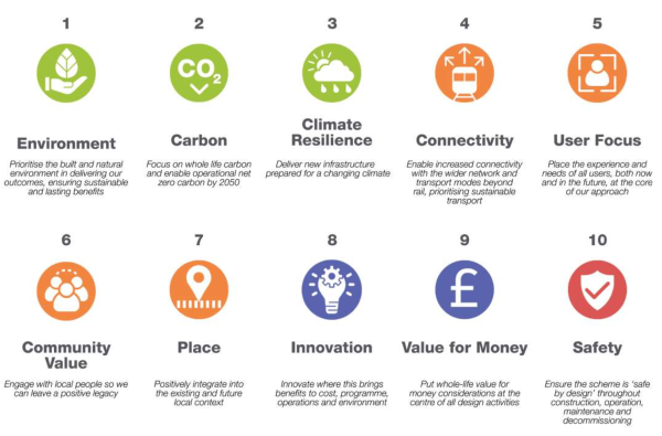
Figure 6: Overview of the ten project level design principles
Application of the design principles
The design principles apply to all aspects of the project and guide how we approach both the construction and operation of the railway. We’ve grouped these principles into the following elements:
-
Stations
-
Ancillary assets (including depots)
-
Structures (bridges, footbridges, tunnels, viaducts and culverts)
-
The environment and landscape
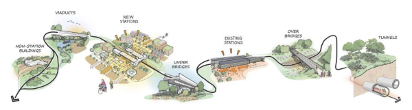
Figure 7: Illustration showing the breakdown of some of the EWR project elements where design principles are being applied
As part of our DCO application, we’ll produce a Design Approach Document that sets out the design process applied to date and explains how the design responds to the design principles. These principles will also provide the framework for the future design and construction of EWR.
Illustrated below is a high‑level example of how the design principles are being interpreted and applied to our stations. In this example, the principles have been considered during option selection and throughout the development of the station designs, including consideration of the layout, access arrangements and integration with the surrounding environment. These design choices reflect not only current requirements but also the long‑term operation and adaptability of the railway, such as predicted future demand, operational resilience, climate risk, and evolving industry standards and technological advances.
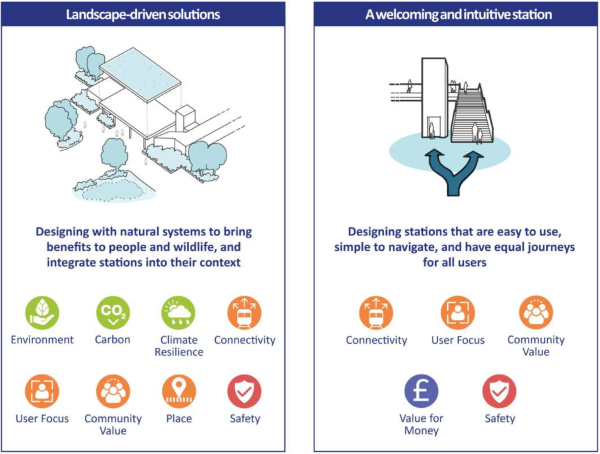
Figure 8: Example of a station, its physical consideration and the relationship to the project level design principles The following sections explain how the design principles are informing the development of key elements of the project.
The following sections explain how the design principles are informing the development of key elements of the project.
Considering the principles
Approach to stations
We’re applying a consistent approach to the design of the new stations, guided by the design principles and relevant technical and accessibility standards, with an approach that encourages and integrates with new homes, shops and offices close to the stations. Our design principles address key themes, including:
Adaptable station designs
We’re designing stations with modular components (kit‑of‑parts) to allow future adaptability and flexibility. This would help to meet the evolving demands of passengers.
Prioritising pedestrians and active travel
All new stations would encourage active travel through the provision of cycling facilities and integration with new and existing walking, wheeling and cycling routes.
Welcoming and intuitive stations
Stations would include step‑free access throughout with platforms designed to accommodate wheelchairs, mobility aids and prams. These would be supported by fully accessible passenger facilities, with canopies where appropriate to protect passengers from the weather. Stations would be designed to be intuitive where possible, allowing for ease of navigation and less reliance on signage.
Clarity of onwards connections and travel
New stations would be designed to provide clear wayfinding and straightforward passenger movement. Clearly defined pick up and drop off areas for cars, taxis and buses would be included, along with appropriate car and cycle parking provision. All new stations would include bus facilities either within the station site or on adjacent roads. Where needed to meet forecast demand and reflect local space constraints, we expect to provide either ground‑level or multi‑storey car parks.
Landscape-driven solutions
We’ll design stations so they feel integrated into their context. We’ll do this by balancing modular design with the material characteristics of the existing landscape and surrounding environment, and by applying site‑specific landscape treatment where appropriate.
Safety
We would build stations that are safe by design so that they follow established best practice to support passenger safety, accessibility and ease of movement, including appropriate security measures like CCTV.
Station facilities
The provision of passenger facilities and shops would be appropriate to the needs of each station.
-
At stations serving commuters from a relatively small area, facilities could include small‑scale community retail offers such as convenience retail and small food and beverage kiosks, likely to be provided within the station forecourts.
-
At interchange stations, where passengers are expected to spend longer periods of time, retail could be provided in both the concourse and platform areas such as convenience retail and ‘grab‑and‑go’ food and beverage kiosks.
-
At larger stations serving as gateways to visitor attractions and communities, passengers are expected to arrive from further afield. These passengers would have higher expectations for station facilities and shops and would spend longer periods of time in the concourse. These stations would have larger retail areas designed for passengers who are travelling to a destination, possibly connected to nearby developments or shops in the forecourt.
All stations would include toilets. Some stations would have staff on site, with accommodation sized to meet day‑to‑day needs.
Stations that support local growth
We’re designing stations with consideration for both existing and future development in the surrounding area. We’re working with stakeholders and developers to ensure our station layouts meet the needs of local ambitions and make the most of opportunities for integration. This includes:
-
The way the proposed station connects with the local area now and in the future
-
Placemaking opportunities and interactions with other projects
-
Relevant information from Local Plans and related local planning documents, such as proposed housing developments and local works or upgrades being considered in the area
-
Local jobs and community needs, along with the schools, healthcare, and other services already in place
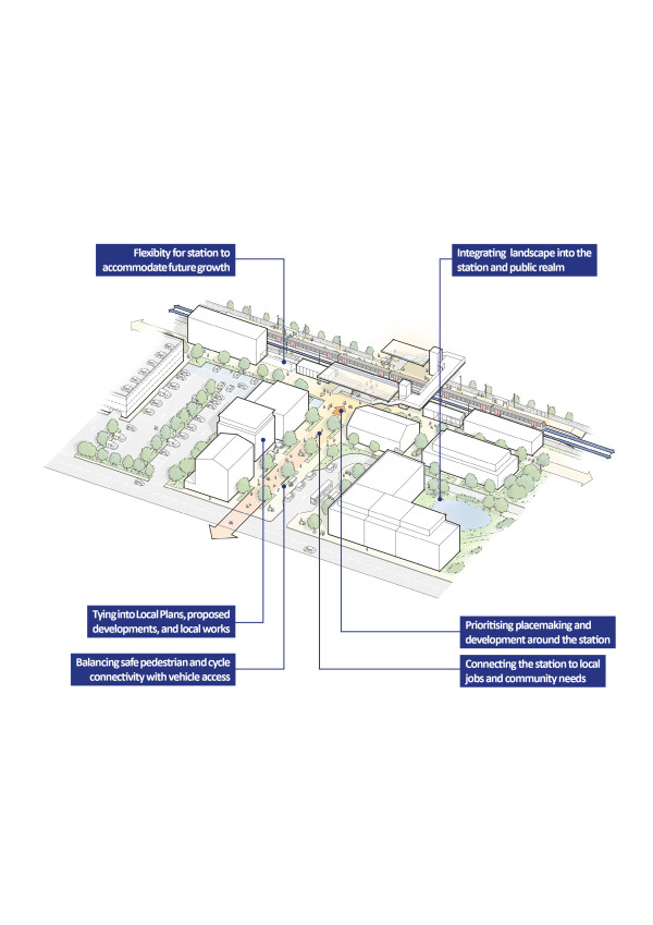
Figure 9: How our stations could support local growth
Approach to structures
We’re designing structures that are appropriate for their local context, while remaining functional and consistent to support efficient construction and help minimise wider impacts on people and the environment.
Our design approach addresses key themes, including:
Responding to context
Responding to context involves adapting designs where appropriate to better suit their surroundings. We use a carefully developed kit‑of‑parts, enabling components to be combined in ways that align with the local environment. This approach gives us standardisation of design while retaining the flexibility to adapt to specific site conditions or operational requirements.
Unique responses
Whilst we plan to use consistent materials and designs to ensure value for money, these can be applied in ways that respond to the local context. In some cases, one‑ off designs may be needed where the standard set of components (kit‑of‑parts) is not appropriate. In these situations, the design response is tailored to the specific site, purpose and appearance, helping us address unusual challenges in a way that fits well within the surrounding environment.
Inclusive design
We’re applying inclusive design principles to ensure structures are welcoming and usable for all users including public, passengers and staff. This includes establishing an East West Rail Accessibility Advisory Panel and engaging Network Rail’s Built Environment Accessibility Panel to test emerging design proposals. By integrating the principles of equity, universal usability, and accessibility into every stage of the design process, this approach assures that infrastructure accommodates diverse needs.
Be a good neighbour
Being a good neighbour focuses on minimising disruption and providing positive benefits to local communities. This includes managing noise, vibration, light pollution, and visual impacts, while also planning construction logistics to help minimise potential disruption to local transport networks and provide alternative solutions where needed.
The design we’re proposing for the viaduct near Ravensden is a good example of how we’re applying these design principles. Previously, we proposed two small bridges and a large embankment. The design has now been changed to a single viaduct, which responds to its context by preserving views that the previous proposal would have blocked, while using the same standard kit‑of‑parts used elsewhere on the project to support consistency and efficient construction. In addition, this design reduces the extent of roadworks and disruption during construction of the crossing.
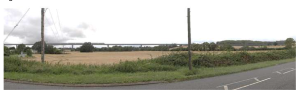
Figure 10: An indicative illustration of the viaduct near Ravensden
Approach to depots and other supporting items
With preferred sites selected for depots and other supporting items of infrastructure, we’re now using the project‑level design principles to guide the design development of these sites to ensure they are functional, efficient and sensitive to their surroundings.
Some of the key themes we’re considering are:
-
Sensitive design – The form and footprint of depots and supporting buildings are a result of its required use. However, we’re looking at ways of minimising its visual presence through choice of material, shape and use of landscaping to screen them.
-
Strategic design – We want to minimise waste and optimise use of resources so we’re focusing on standardisation, prefabrication and adaptability to enhance the long‑term efficiency of operations while reducing environmental impacts.
-
Sustainable approach and construction practices – We’re designing our railway with sustainability in mind to support EWR’s net‑zero energy strategy, which includes the local sourcing of material, maximising green infrastructure, and careful selection of materials.
-
Safe and secure environment – To ensure railway workers have a safe environment to work in, we’re focusing on spatial organisation to clearly denote areas for different activities as well as maximising opportunities for light and health benefits to provide a positive environment for all.
Approach to environment and landscape
Our project‑level design principles respond to our Environmental Sustainability Strategy. This strategy focuses on the natural environment, carbon, climate resilience, the historic environment and landscape, the circular economy, and people and communities. These principles have informed all aspects of our design and support our ambition to achieve biodiversity net gain.
This approach is particularly important in how we design new landscape and environmental features.
You can find more information on how environmental sustainability has shaped our proposals in the Our approach to the environment chapter of this consultation brochure.
8. Door-to-door connectivity, including active travel
As part of our plans to better connect communities and businesses in the region, we’re proposing improvements to local transport networks so that people can reach their local stations safely and conveniently.
Good door‑to‑door connectivity means giving people more choice in how they travel to and from the station. To achieve this, we’re considering the whole journey people want to make – not just the part taken by train. Our station designs and wider proposals support access by walking, wheeling and cycling (collectively referred to as active travel), as well as by bus, car and other forms of transport.
We would provide modern station facilities, ensuring there is seamless bus interchange, secure cycle parking, appropriate car access, suitable provision for taxis and pick up and drop off points, as well as clear information and wayfinding that helps people travel with confidence.
For many journeys, walking, wheeling and cycling on safe, direct paths are often the most practical ways of reaching a station. These also have great health benefits and reduce congestion and pollution on local roads by turning what could be a car trip into a short walk or ride.
For longer journeys, beyond just providing facilities at stations, we’re working with partners (including England’s Economic Heartland) to consider how bus networks and more extensive walking and cycling routes could enable a change in how people get around the region.
Our approach is guided by the following considerations:
-
Providing connectivity to and from stations, including to areas identified for potential future homes, businesses and employment opportunities
-
Making journeys to and from the railway feel safe, seamless, and convenient
-
Maximising the opportunity for people to choose active travel while recognising this is not always possible for some
This section explains what we propose as part of EWR, and how we’re working with partners to support the provision of other complementary measures. Further information on our door‑to‑door connectivity proposals can be found in the route section chapters and on Active Travel maps available at eastwestrail.co.uk/consultation2026
Stations as mobility hubs
We’re designing stations to function as effective mobility hubs, making it easy for people to switch between different modes of transport as part of a single journey. Our station designs include space for future growth, ensuring that facilities such as car parks, bus stops, and areas for bicycles and scooters can be expanded over time as more people choose to use the railway.
Across the route, stations perform different roles depending on their location and catchment. Some are situated in town centres with strong walking and cycling connections, while others serve rural communities or emerging growth areas where bus connections or cars are required to get to and from the station. Our approach recognises these differences and avoids a ‘one size fits all’ model for what a mobility hub should include.
At this stage, our work on stations as mobility hubs focuses on establishing clear design principles. These include creating stations that are safe and easy to navigate, enabling convenient interchanges, inclusive access for all users, and flexibility to adapt as travel patterns change.
While these principles guide the design, many of the features that contribute to successful mobility hubs – such as easy access to local buses, integrated ticketing, or shared mobility schemes – depend on collaboration with local authorities and other partners to explore appropriate funding and delivery approaches.
What East West Rail would provide
The measures EWR would provide include both new and upgraded walking, wheeling, and cycling routes, making it easier for commuters and leisure customers to travel by train. As well as well‑designed station facilities, we’ll introduce new bridges or underpasses where the railway would affect existing routes – ensuring communities are not cut off from each other. These measures are central to maintaining and improving access to stations.
Active travel
Active travel is a key component of door‑to‑door connectivity. Strong interest in this topic has been expressed at previous consultations.
We want to make walking, wheeling and cycling attractive, obvious choices for accessing stations by providing safe and direct routes that connect stations with nearby communities, both those which exist now and new ones in the future.
We would use best practice in design to address the potential for misuse of the active travel network by unauthorised vehicles and to prevent and deter anti‑social behaviour and unauthorised access to third‑party land.
New and relocated stations
For new stations, we’re designing direct, well‑lit paths, as well as secure cycle parking, and clear information so people don’t have to cross awkward junctions or walk along narrow verges.
For example, new active travel routes are proposed between Aspley Guise and both Woburn Sands and Ridgmont stations, designed to make it easy for the local community to access the railway.
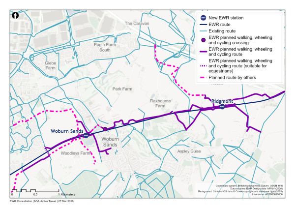
Figure 11: Map showing planned active travel routes between Aspley Guise and both Woburn Sands and Ridgmont stations
At existing stations, we plan to upgrade existing paths, improve signage and wayfinding, and increase the availability of secure cycle parking.
Managing the impact of the railway
In addition to improving access to stations, active travel plays an important role in managing the impacts of the railway on local connectivity.
In some locations, new sections of railway may affect existing footpaths, equestrian routes, or public rights of way – creating new barriers between communities and facilities. Where this occurs, we’re committed to providing appropriate diversions or replacement routes, ensuring people can still move around safely and conveniently.
These measures are integrated into the design of the railway and further detail on specific proposals is provided in the relevant route section chapters.
Equestrian routes
We recognise from previous consultation feedback the importance of equestrian access and bridleway connectivity in rural areas. Where appropriate, our proposals include measures such as new bridleways and Pegasus (equestrian) crossings to maintain safe and continuous routes for horse riders, alongside people walking, wheeling and cycling.
Within the Croxton to Toft route section, for example, we would provide a new multi‑ user route alongside St Neots Road with new crossings for equestrians and people walking, wheeling and cycling. This route would connect Knapwell Bridleway 10 with equestrian routes on the new Brockley Road bridge which would cross over the railway.
What East West Rail would enable
We’re working closely with local councils, developers and other transport bodies to integrate our proposals with wider local travel networks. In some locations, new developments or parallel infrastructure projects would enable additional connections that build on those provided directly by EWR.
For example, our engagement with the Bletchley and Fenny Stratford Town Deal Improvement scheme is enabling high‑quality active travel enhancements along Aylesbury Street, Queensway and Saxon Street to be directly aligned with station access proposals, creating a consistent and legible route into the station from neighbouring areas.
Along the Fenny Stratford to Kempston corridor, planned development, including the South East Milton Keynes Strategic Urban Extension, offer opportunities to embed additional walking and cycling routes at the masterplanning stage. These developments would meaningfully extend routes provided by EWR to help create a continuous network that supports connectivity into our stations for both current and future communities.
We’re also working with National Highways to coordinate our proposals with the A428 Black Cat to Caxton Gibbet improvement scheme. At Cambourne, new shared‑use paths associated with the highway scheme provide an opportunity to provide safe, direct and convenient connections into the station, maximising the value of parallel investment and reducing the need for standalone interventions.
Taken together, this approach shows how EWR is using partnership working to unlock a change in door‑to‑door connectivity, ensuring that station access is not provided in isolation but as part of a wider, integrated network across the corridor.
Our approach to bus integration
Buses play an important role in expanding the catchment of a station, enabling more people to use the railway, particularly in rural areas and for people who don’t have access to a car.
Our work is focused on enabling better integration between bus services and the railway. This includes designing station layouts that can safely and conveniently accommodate buses, with space for potential future service improvements, clear interchange points and minimal walking distances.
While local transport authorities – supported by strategic partners such as England’s Economic Heartland – are responsible for specifying and providing the bus services that would connect people with the railway, we’re working collaboratively with them, and with bus operators, to consider what a coherent and convenient regional bus network could look like.
Our approach to access by car
While our aim is to make rail a convenient alternative to longer car journeys – helping people reach their destination without having to drive into busy towns and cities ‑ for many people, particularly in rural areas, driving may remain part of how they reach the railway.
Access to stations would be planned carefully, using existing routes where possible and ensuring local roads aren’t put under additional strain. By enabling more of each journey to be made by train rather than by car, our plans aim to reduce congestion overall.
Our approach is to manage car access carefully, prioritising the most sustainable choices wherever they’re realistic and safe. We would provide appropriate levels of car parking, electric vehicle charging points, and efficient drop off areas, alongside good facilities for taxis and passengers with reduced mobility.
By ensuring these arrangements are balanced and efficient, EWR would reduce unnecessary car journeys, and make it easier for people to choose more active and sustainable modes like walking, cycling, or the bus wherever they can.
9. Our approach to the environment
Our approach to the environment is comprehensive, proactive and embedded in the decisions we make at every stage of the project.
Our goal is for the railway and the habitats we create to contribute to wider nature recovery in the area and provide valuable access to wildlife and green space for communities across the region. This is why environmental sustainability considerations are reflected in our project level design principles, helping inform all aspects of our proposals.
We also want our proposals to respond to and support wider nature ambitions. To do this, we’re working closely with the Department for Environment, Food and Rural Affairs (Defra) on their plans for a new national forest in the region. A new national forest would help deliver national renewal for communities, driving economic growth while enhancing nature and bringing more accessible woodland and green space closer to communities.
At our previous consultation, we provided an update on our Environmental Sustainability Strategy. The strategy sets out the six environmental pillars and the strategic objectives that are shaping the ongoing development of the railway. The pillars relate to the natural environment, carbon, climate resilience, the historic environment and landscape, the circular economy, and people and community.
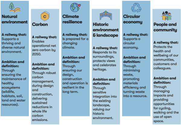
Figure 12: The six pillars of our environmental sustainability strategy
Work carried out since the previous consultation
Since our previous consultation, we’ve carried out further work to help us better understand the impacts our proposals may have and how we can avoid, reduce or mitigate these impacts as we finalise our designs.
Surveys and information gathering
We have:
-
Completed approximately 5,000 site visits to gather detailed information about existing environmental conditions along the proposed route. These include farm business interviews, visits to community facilities, and surveys of noise and vibration, traffic and transport, and river channel conditions for flood risk assessments.
-
Undertaken ecological surveys, including for birds, bats, badgers and terrestrial invertebrates in areas where the project may affect sensitive habitats or species. These surveys are helping us understand what mitigation may be required to protect these habitats and species.
-
Carried out investigations to identify areas that may contain valuable archaeological features, enabling us to adjust our proposals where possible and develop appropriate mitigations for construction.
-
Undertaken ground investigations to understand below surface soil, rock and groundwater conditions. This work is helping us design the railway responsibly and in an environmentally sustainable way by maximising the amount of material that can be reused during construction.
Engaging and collaborating
We have:
-
Spoken with landowners and agricultural businesses to help manage our impact on their operations and shape proposals for habitats and other environmental features on their land.
-
Worked with statutory environmental bodies and local authorities to share our emerging understanding of impacts and the mitigations we propose to manage these.
-
Collaborated with other major projects, such as the new A421 dual carriageway, to review available survey data and coordinate our mitigation proposals.
-
Set up a Biodiversity Net Gain Forum to bring together interested parties. This forum contributes knowledge and expertise to help us develop plans that support improvements in biodiversity. Members include local councils, RSPB, Natural England, the Environment Agency and Cambridge University.
-
Established a Water Forum to engage with relevant stakeholders on how to avoid or mitigate impacts to rivers, watercourses, ponds and lakes that are crossed by the project, and to inform our approach to managing flood risk. This forum includes local lead flood authorities, Natural England and the Environment Agency.
Refining the design
-
Achieving good design is key to our environmental ambitions for the railway. Our approach has focused on using the outputs of environmental surveys, initial appraisals and modelling to guide the design process and incorporate the right mitigations in our proposals.
-
The mitigation of potentially significant effects is fundamental to meeting our sustainable development objectives for the project. Our approach follows the mitigation hierarchy, shown in the figure below. This is a framework established in environmental good practice, prioritising the order in which different measures should be considered to reduce potential impacts. Priority is given to designs that avoid or minimise environmental impacts at source. Where impacts are unavoidable, we look to develop mitigation designs that would rectify or compensate for losses and offer alternative forms of enhancement or benefit.
-
The measures we’ve included in our proposals follow best practice for major infrastructure projects. The measures respond to policy set out of National Networks National Policy Statement and existing legislation in place to support environmental protection.
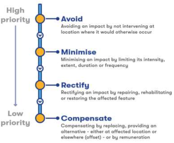
Figure 13: Overview of the mitigation hierarchy
Initial analysis as part of the scoping process for the project, along with more detailed assessments and survey results, has helped us understand the railway’s potential impacts and how best to mitigate them.
Since our previous consultation we’ve further developed our design to avoid and reduce potential impacts, including:
-
Repositioning specific design features in response to previous consultation feedback, and where there are opportunities to further reduce the project’s potential environmental impacts
-
Using the outputs of environmental surveys, and initial appraisals and modelling, to guide the design process with a view to minimising environmental effects
-
Developing our environmental mitigation proposals, including identifying suitable locations for new woodland, tree planting and other habitat creation. These measures help to offset any habitats lost during construction and help the new railway blend into its surroundings
-
Lowering the height of the proposed railway alignment in specific locations so that embankments and structures would be less visible from surrounding neighbourhoods
-
Carrying out more detailed work that would protect surrounding communities and the railway from flood risks, which is particularly important in a changing climate
As more information becomes available through ongoing environmental survey and assessment work, we will further refine our mitigation proposals and test these through engagement with technical stakeholders. We’ll also continue to work with landowners and other interested parties and adapt our mitigation proposals so they align with their needs where possible.
The proposals presented in this consultation reflect the ongoing survey and assessment work. The proposals we’ve included aim to achieve multiple benefits wherever possible through providing well‑connected green infrastructure for wildlife, people and communities.
The sections below provide examples of how our approach is achieving this with further detail set out in the route section chapters.
Biodiversity and nature recovery
We’re looking at ways that our mitigation proposals might support nature recovery strategies in the wider area. This includes chalk stream restoration, wetland creation, woodland expansion and incorporation of habitat extensions supporting nature recovery strategies.
Examples include:
Islip
There are a number of priority habitats in the Islip area, focused along Gallos Brook and its tributaries, including areas of potentially irreplaceable habitat. We’ve relocated the drainage ponds and access roads associated with the passing loop at Islip to avoid the most sensitive areas of habitat and are exploring opportunities to create additional areas of woodland and grassland to strengthen the green corridor along the brook.
Hardwick
The Hardwick area forms part of the core sustenance zone for Wimpole and Eversden Special Area of Conservation (SAC) and connects to a number of important priority habitats in the wider area. We propose to create two multifunctional green bridges to address potential severance impacts for protected species in this area. A green bridge is a structure that carries a highway or public right of way crossing that is made wider to accommodate planting and habitat creation alongside the highway or right of way. This approach has been shown to be effective at helping maintain ecological connectivity between habitats on either side of linear infrastructure, supporting species movement.
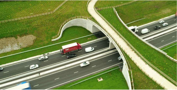
Figure 14: Photograph of an existing green bridge on A556, west of Mere (photograph courtesy of National Highways)
We would also incorporate earthworks as well as tree and hedgerow planting along this section of route to encourage protected species to use these crossing points. We would divert a watercourse to the east of the proposed railway and would provide additional planting to encourage protected species to follow the course of the river.
We’re exploring ways to maintain and enhance the existing watercourse on the west side of the railway and to provide better opportunities for nature recovery where the two watercourses converge at a point just north of Hardwick Green Bridge.
Bourne Brook, between Bourne and Harlton
The alignment of the railway viaduct has been modified so that it crosses Bourne Brook at a narrower part of the floodplain. The design and height of the viaduct have also been refined to provide clearances for bat movement, and to minimise fragmentation and loss of habitats along the banks of the watercourse.
Surveys carried out to date have found the condition of existing habitats along the Bourne Brook area to be varied, with some sections in moderate or poor condition. Our mitigation proposals would focus on opportunities to improve existing habitats where they are in poor condition. Surveys also identified shortages of lowland meadow and marsh, offering important opportunities for us to enhance and create these habitat types and connect them with existing retained riparian (waterside) habitats.
Green infrastructure, landscape and strategic connectivity for people and nature
Green infrastructure refers to networks of natural, planted or vegetated spaces and corridors – such as parks, gardens, woodlands, and hedgerows along footpaths and bridleways. These areas provide important habitats for wildlife and help connect different parts of the natural environment. They also support community wellbeing by offering space for recreation, as well as safe and healthy walking and cycling routes.
To help meet our sustainability goals, our design looks for opportunities to enhance and strengthen green infrastructure networks along the route, benefiting local people and the environment. We’ve taken a multi‑functional approach to our mitigation design. This is particularly important for promoting high‑quality and sustainable access to new stations in ways that work for existing communities and areas where future development is proposed. It is also relevant where existing rights of way need to be diverted around the railway, or where other features such as drainage and habitat creation can be combined.
Below, we outline specific examples of how we’re applying this approach.
-
Bedford North: We’re exploring opportunities to enhance the open extensive floodplain character associated with the River Great Ouse valley to the north of Bedford to address impacts on habitats. The local nature recovery strategy for this area recommends managing vegetation and restoring areas of wetland associated with the river floodplain. Our mitigation proposals aim to maintain and enhance areas of existing floodplain, and create new areas to improve wetland connectivity.
We’re also looking at ways we could extend public access along the river corridor and to Bromham Lake Local Nature Reserve on the north side of the river. Further information on this can be found in the Bedford chapter.
-
Tempsford: An important ecological consideration at Tempsford is to maintain east‑west connectivity between areas of priority habitat and ancient woodland to the east of the railway, including Abbotsley Downs and Sir John’s Wood and the Great River Ouse green corridor. Our mitigation proposals at Tempsford aim to integrate the railway with the landscape, connect the fragmented habitats and maintain connectivity to the Great River Ouse floodplain.
To maintain species and habitat connectivity, we’ve created an extension to the A421 dual carriageway’s proposals for a mammal crossing supported by hedgerow planting to form a wildlife corridor that runs from a point east of the A421 dual carriageway across to the Great River Ouse. We’re engaging with landowners to explore opportunities to reinforce and extend this wildlife corridor as part of planned developments for the wider area. Further information on this can be found in the Roxton to east of St Neots chapter.
-
Hen Brook, east of St Neots: We’re exploring opportunities to enhance the Hen Brook corridor through the use of planting along the watercourse. This would link fragmented woodlands and provide better connectivity for wildlife and access to nature. The planting would also improve the east‑west bat flight corridors that have already been identified as part of the A428 Black Cat to Caxton Gibbet improvement scheme at Hen Brook.
We’re also looking at opportunities to connect floodplains, create new wetland habitat and provide connectivity with associated priority habitats. There are important opportunities for biodiversity net gain along the river corridor with the potential to provide stepping stones to other areas of priority habitat between Caldecote, the Hen Brook river corridor and Wyboston Lakes. Further information on this can be found in the Roxton to east of St Neots chapter.
-
River Rhee and River Cam: The River Rhee and its tributaries are chalk streams that support nationally and internationally recognised unique habitats. We’ve made several important changes to the height and design of the proposed viaduct in this area, to make sure that people could continue to use the footpath along the river bank and maintain habitat connectivity for important species.
We’ve reviewed the impact of the proposed structure on flood risk and are continuing to explore opportunities to support the reinstatement of floodplain meadows along the watercourse to support nature recovery and protect water quality. Further information on this can be found in the Comberton to Shelford chapter.
-
Clapham and Wilden: We’ve adjusted the alignment and height of the railway alignment between Clapham and Wilden as it crosses the ‘fluted valley’ landform to better respect the existing topography. The refined alignment avoids permanent land take from Bedford and County Golf Club and a proposed solar farm, and maintains a buffer distance between the railway and Clapham Park Wood, an area of ancient woodland. By repositioning Clapham Footpath 5 and Footpath 6 to a point 50 metres further north and widening it so that it crosses the railway on a green bridge, we’ve been able to address the severance impacts for both people and wildlife with a single structure. Our proposed mitigation planting proposals are designed to improve habitat connectivity between existing areas of ancient woodland, parkland and community forest and minimise impacts to agricultural uses on the west side of the railway.
We’ve also incorporated viaducts into the design at Ravensden and South Brook West to retain the long views and maintain an appreciation of the landscape. Further information on this can be found in the Clapham Green to Colesden chapter.
-
Bourn to Harlton: The landscape between the Bourne Brook and Harlton is predominantly lowland farmland. A key priority in this area has been to conserve the sense of openness and protect long views across the lowland landscape. We’ve reduced the height of the railway at this location by 6 metres and have changed the design of the A603 Cambridge Road to take the form of a green bridge over the railway, providing better opportunities for habitat and species connectivity and landscape integration.
We’ve moved the point at which the railway crosses Long Brook 200 metres to the east so we can keep the height of the railway lower for longer. As part of realigning Long Brook, we’ve introduced gentle curves into the design of the channel. This would help it behave more like a natural stream and would better support local wildlife and natural water flow. Further information on this can be found in the Comberton to Shelford chapter.
Archaeology and built heritage
Construction of the project would have some adverse impacts on heritage features and could permanently or temporarily affect their setting and appreciation. Our priority has been to avoid negatively affecting the significance of heritage assets where possible through sensitive route alignment and careful delineation of works close to heritage features.
We’ve collected more information about the historic environment and used this to make localised design changes to reduce impacts, including relocating features and incorporating measures to provide visual and acoustic screening. We present some specific examples of how the project has been developed to incorporate such mitigation below.
-
Colesden: Geophysical archaeology survey within the Colesden area identified archaeological remains near to Colesden Lodge Farm and Rockingham Ditch. This survey information has informed the design of the construction compounds and stockpiles resulting in their relocation to the south side of the railway. We’ve also designed mitigation planting to respect the potential archaeology on the north side of the railway.
-
Cambourne: As ground investigation data becomes available, we’ve been able to refine the positions of construction compounds and stockpiles to avoid areas of potential archaeological interest. At Cambourne, for example, we’ve mitigated the impacts to Lawn Farm and relocated the proposed stockpile areas to avoid a large Romano‑British settlement that has been identified.
-
Great Shelford: With the addition of two tracks on the west side of the existing West Anglia Mainline, some direct impacts to the scheduled monument west of White Hill Farm would be unavoidable. To mitigate these impacts, we’re proposing to take the land area currently designated as a scheduled monument out of agricultural use and develop more comprehensive landscaping proposals that would connect with the extension of Hobson’s Park Country Park immediately to the north. As part of these proposals we’re also exploring opportunities to enhance the existing Hobson’s Conduit, as well as improving public access to this historically important site.
Noise and vibration
Noise would be generated during construction of the railway by activities such as demolition, roadworks and earthworks. Once the railway and roads are operational, train movements, the operation of maintenance facilities and changes in vehicle traffic would generate noise.
Vibration would be generated by construction activity such as piling and tunnelling. Vibration impacts are likely to be minimal during operation due to measures incorporated into the design of the tracks, structures and trains. Our assessment of noise and vibration effects is ongoing and the results will be reported as part of the Environmental Statement (ES).
We’re designing the railway to reduce noise and vibration at source where possible. This includes keeping the track low in the landscape as this would help reduce the spread of noise. Noise mitigation would, however, be required in a number of locations to further reduce noise levels experienced by nearby communities and other sensitive receptors from the operation of the railway. This would likely take the form of noise barriers consisting of solid fences located alongside the railway tracks.
Our proposals are currently using preliminary assessments and professional judgement to identify likely noise barrier locations, which have been identified on the plans and described in each route section. The precise heights and locations of the barriers would be determined through our ongoing noise modelling.
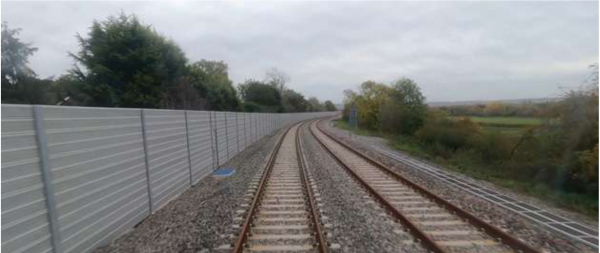
Figure 15: Photograph of an existing noise barrier installed between Bicester and Bletchley
Our noise assessment will follow the policy and guidance set out in the Noise Policy Statement for England 2010 (as described in our EIA Scoping Report). This involves identifying the noise levels which in specific contexts could have adverse effects on health and quality of life. The ES will identify the significant noise and vibration effects during construction and operation of the railway. It will also identify measures to mitigate the significant effects.
Community
We’re considering how the project proposals would affect residential and community assets and networks, as well as the health of local populations. This includes loss of residential properties, as well as loss of or impacts on community facilities supporting health, education or amenity, including open spaces.
Our assessment considers how settlements, or closely associated settlements, may be actually or perceptually separated by the railway. It also considers how other environmental impacts and effects (noise, visual, dust, traffic) might act in combination to impact community amenity, health and quality of life.
Sources of community impact would include:
-
Loss of land associated with residential property and community facilities
-
Demolition of residential property and community facilities
-
Loss of open space and severance or diversion of public rights of way
-
Separation (or perceived separation) of linked communities through the introduction of temporary or permanent infrastructure, such as the railway track itself or level crossing closures
-
Combined impacts affecting the noise and visual environments, air quality, access, and traffic characteristics
Our proposals include measures to address these impacts. For example, in south Bedford area we’ve included replacement open space to address the open space removed for the realigned tracks.
Flooding and water
One of our key considerations is how the project interacts with watercourses and areas that flood naturally, often referred to as floodplains. While avoiding floodplains is always preferable, it’s inevitable that the route would have to pass through them, and potentially occupy land that currently helps store water during flood events. Reducing the capacity of flood storage in one location could increase flood risk elsewhere.
One way to avoid increasing flood risk is to limit the railway’s footprint within floodplains – by using viaducts for example. Where this is not practical, another potential solution is to provide flood compensation areas.
We’re continuing an extensive flood risk modelling to inform these decisions. This work is helping to refine the design. We’re working closely with the Environment Agency and other stakeholders to share and develop our findings.
Carbon
We’re committed to delivering a net zero carbon passenger railway in line with the UK’s statutory climate commitments. We aim to reduce whole life carbon across construction and operation by prioritising carbon avoidance and reduction at every stage of development.
Low carbon outcomes are embedded within our design principles, and our proposals include opportunities for reusing and refurbishing existing assets to reduce the need for new construction, optimising designs to minimise material use, and specifying lower carbon materials.
Our electrification proposals would reduce operational emissions from running services on the railway, and the new railway would enable additional freight paths, helping to cut emissions from HGVs on local road networks. New stations and buildings are being designed to be energy‑efficient and to minimise operational emissions.
We’re carrying out a whole life carbon assessment. This involves calculating emissions across the project lifecycle, including construction, operation, use, maintenance and decommissioning the infrastructure. We’re also preparing a carbon management plan that will explain the steps we’ve taken to reduce the project’s carbon impacts, and reports the level of residual emissions in the context of the UK’s statutory carbon budgets.
Environmental impact assessment process
We’re carrying out an environmental impact assessment (EIA) of our proposals in accordance the Planning Act 2008 and the Infrastructure Planning (Environmental Impact Assessment) Regulations 2017.
Carrying out an EIA is a comprehensive process that involves:
-
Establishing baseline environmental conditions through surveys and desk studies
-
Using modelling tools to predict impacts. For example, for noise, air quality, flood risk and traffic
-
Collaborating with other relevant infrastructure projects to share data
-
Considering combined impacts with other projects
-
Applying the mitigation hierarchy: avoid, reduce, rectify, compensate
-
Embedding mitigation measures into the design, for example tunnels, planting and drainage systems
-
Consulting with stakeholders and regulatory bodies, for example Natural England and the Environment Agency
-
Identifying the likely significant environmental effects and any additional measures to mitigate them
The EIA covers a wide range of topics grouped into three categories:
-
People and communities – noise, air quality, visual impacts, agricultural property impacts, community, health and socioeconomics
-
Landscape and the historic environment – archaeology, heritage assets
-
Natural environment – ecology, flooding, water resources, climate
In January 2025, we submitted an EIA scoping report to the Planning Inspectorate, setting out the proposed scope of the environmental matters to be assessed and the methodologies to be used. This marked a key milestone in the project’s development. It initiated a formal consultation, led by the Planning Inspectorate, with a range of statutory bodies whose feedback informed the scoping opinion, which was adopted by the Planning Inspectorate (on behalf of the Secretary of State) on 12 February 2025.
The scoping opinion sets the parameters that we should follow when assessing the environmental effects of the scheme. These documents are published at nationalinfrastructure-consenting.planninginspectorate.gov.uk/projects/TR040012/ documents
The full results of the EIA will be presented in an ES that will be submitted with our DCO application. The information will be taken into account by the Secretary of State when deciding whether to grant development consent for the project.
10. Our approach to traffic and construction
Building the railway would require a range of construction activities and vehicle movements that would need to be carefully managed. This includes planning where compounds and access tracks are located, and identifying construction access routes that avoid or reduce the impacts on local communities as far as is practicable.
This chapter details our approach to managing construction activity and associated traffic, including how people, materials and equipment would move around during construction. Further information can be found in the route section chapters.
Assessing the impact on traffic and transport
We assess traffic and transport impacts during construction and operation. Our approach is evidence led and shaped by highway authority feedback. It is designed to:
-
Minimise disruption during construction
-
Support sustainable travel choices during operation
-
Take into account any accessibility requirements
-
Minimise the risk of congestion in locations where EWR leads to more traffic, when the railway is in operation
We’re assessing how the proposed railway could affect people’s travel patterns and the existing transport network during construction and operation. This helps us to understand everyday journeys in the area – whether walking, wheeling, cycling, getting the bus or driving. We’re working with National Highways and local highway authorities to understand impacts on the roads they manage and identify ways to mitigate them.
Our assessment also considers the impact of works on local traffic at different times of the day, including peak periods. We will set out an approach in construction management plans for making other modes of transport, such as buses, as accessible as possible throughout the construction.
The outcomes of this work will be reported in a transport assessment (TA), submitted as part of our DCO application.
Assessment approach
We assess traffic and transport impacts using a combination of methods including stakeholder engagement, highway modelling and road safety assessments (including pedestrian modelling). The evidence informs recommendations to mitigate impacts and keep people moving safely and efficiently.
Highway transport modelling
We’re creating a detailed highway model, which is a digital tool that helps us predict how traffic patterns on the highway network around the EWR route might change. It allows us to test different scenarios, understand how the road network could be affected, and identify where improvements or mitigation may be needed during the construction and operation of EWR. We’re working closely with local authorities, and the model considers other developments like new transport projects, housing developments, and proposed job sites. The model covers both construction and operation of the railway, helping us predict and identify ways to manage potential congestion. We’ve carried out traffic surveys to ensure the model accurately represents the most up to date traffic conditions.
The outputs from the model will provide metrics for us to understand how the highway network is performing, with key indicators being changes in capacity (which indicates congestion) and delays.
In addition, we’re also using junction models to further assess some locations to test parts of the design as well as further review localised impacts identified in the wider highway model and assess the suitability of proposed mitigation to address these.
Modelling around stations
We’re undertaking detailed modelling of all the stations, which includes testing how people move around station entrances, through ticket gates, on the platforms and on bridges. This helps ensure the stations are correctly designed for the number of rail users expected. This takes into account predicted passenger increases due to major developments, such as the proposed Universal Entertainment Resort Complex.
This modelling exercise and other user assessments will inform the approach we take to measures along the route to promote and enable active and sustainable travel. We’re also working with local authorities and others to support the development of opportunities across the wider network. More details can be found in the section on door‑to‑door connectivity, including active travel.
Work carried out since the previous consultation
We produced a Transport Update Report (TUR) as part of our previous consultation. This was a preliminary, qualitative assessment and included our initial transport assessment scoping report. Early outputs from the traffic modelling indicated the potential locations of the highway impacts and these were presented in the TUR.
Since our previous consultation, additional traffic survey information has been collected to refine the model. We’ve also developed the design proposals in more detail and given further consideration to the impacts of other developments in the surrounding area.
Subsequently, the government has granted planning permission for the proposed Universal Entertainment Resort Complex in Bedford. This development would intensify the use of EWR services and change travel patterns on the surrounding transport networks. Our modelling has been updated to take into account the impact of the Universal Entertainment Resort Complex.
We’ve also continued to review feedback and are using it to improve how we assess EWR’s potential impact on the transport network and where we might need to make changes to our design.
We’re undertaking regular engagement with local stakeholders, including local highways authorities, National Highways, Network Rail, Active Travel England and regional transport bodies. Feedback is helping to shape our approach and inform our assessment work.
Potential impacts
As we deliver this nationally significant railway project, temporary impacts on the highway network are expected during construction. These may include periods of delay and congestion, temporary road closures, and temporary closures or diversions of public rights of way. The highway model is likely to indicate increased pressure along construction access routes, particularly in urban areas. We aim to minimise impacts where possible while delivering this much needed transport connection.
Once operational, passenger movements to and from EWR stations are expected to increase demand on surrounding transport networks. This could increase congestion and make it harder for people walking and cycling – for example, at busy crossings and on approaches to stations. Our highway modelling is expected to show pressure on routes to and from stations, and again, especially in urban areas where there’s more traffic on the network.
Proposed mitigation
For construction impacts, mitigation could include timing construction traffic movements outside of peak network periods, amending and applying fixed routes to avoid certain locations or restrictions (such as height or weight restrictions on the highway) or, in some instances, amendments to the highway network to accommodate the extra movements.
For public right of way 51, diversion routes are being identified to maintain connectivity as much as possible for walking, wheeling and cycling during the construction period.
For operational impacts, we’ve sought to minimise these through our design work, embedding mitigation into our proposals. Where impacts remain on the wider highway network, our work will look at highway amendments that could be implemented to reduce potential impacts, such as changing junction forms or amending highway layouts into the project. We’re planning to enable connectivity through improved walking, wheeling, cycling and bus facilities. For example, additional crossing points, better footways and new cycling and bus infrastructure.
Our approach to managing construction impacts
To realise the benefits of a reliable, high‑capacity railway, there would be construction impacts in areas where the railway would be built. These impacts would affect local communities, businesses, other local stakeholders and aspects of the environment. This section explains how our specialists are working with communities and organisations to assess potential construction impacts and develop construction management plans that avoid or reduce impacts as far as is practicable.
To construct the railway, a series of construction compounds would be established along the route. Main compounds and satellite compounds would be used, which would vary in size. Depending on the role of individual compounds, each would include welfare, office, car parking and storage facilities as needed.
Compounds have been located to manage construction activities efficiently whilst seeking to reduce disturbance to local communities and impacts on the environment. For each compound the land usage, traffic route and means of access has been carefully considered. Further information on the locations of these compounds can be found in each of the route section chapters later in this document.
Industry best practices would be applied to control noise, dust, vibration and light pollution at each compound. The proposed construction access routes and compound locations are identified on the plans accompanying this consultation and will continue to be refined as the design progresses. You can view plans showing construction information, including compounds, service roads and key HGV routes at eastwestrail.co.uk/consultation2026 and at our consultation events.
Main construction compounds
Main construction compounds are areas that support the construction of major elements of the project. They are typically located close to key construction activities and require good access to the public road network. These compounds would include temporary site offices for the workforce and support staff, welfare facilities, areas for storing materials and equipment and parking for workers.
Satellite construction compounds
Satellite compounds are smaller sites that are used for more localised activities, such as to support the building of footbridges or constructing rail systems compounds. They may not have direct access from public highways and would sometimes be reached via a temporary internal service road within the site boundary.
Construction working hours
Where practicable construction activity for the new railway would take place during standard daytime hours, with some tasks needing additional time so they can be completed safely and without creating unnecessary disruption.
The following list outlines the different types of construction working hours that we anticipate may be required, depending on the activity and safety requirements:
-
Standard daytime hours – The majority of work would happen during typical working hours on weekdays and Saturdays. This is likely to be between 08:00 and 18:00 on weekdays and 08:00 and 16:00 on Saturdays.
-
Quiet preparation periods – Short periods before and after the main shift may be needed for low impact activities such as briefings, inspections and worker movements, without using machinery.
-
Extended hours – Certain activities that cannot be safely paused, such as large concrete pours, tunnelling works or earth moving activities, may need to continue into the evening or take place on weekends.
-
Time sensitive or weather dependent work – Activities influenced by natural conditions, such as earthworks or those linked to water levels, may need flexibility in timing.
-
Works on or near the railway or major highways – Some construction activities would need to take place on or close to the operational railway or major highways, requiring work to be carried out overnight, at weekends or during planned closures so that activities can be completed safely, minimising disruption to services.
-
Emergency situations – Urgent works required to maintain safety or protect the environment may take place at any time if circumstances demand it.
Works to the operational railway
Where works are needed once the railway is in operation, these would be undertaken outside normal operating hours (typically overnight or at weekends) or within planned possessions or blockades. Possessions and blockades are defined periods during which sections of the railway are closed to passenger services to facilitate construction and maintenance activities.
Construction traffic routes
Construction of the railway would require the movement of materials, plant and workforce to and from worksites and construction compounds. We recognise that construction traffic has the potential to affect local communities. Therefore, managing these impacts safely and responsibly is a key consideration in the development of the project. We’ve thought carefully about traffic management and road safety principles from an early stage, and we’ve been engaging with local authorities, emergency services and other stakeholders to understand local constraints and sensitivities.
In developing our proposals, we’ve identified construction access routes that seek to avoid or minimise effects on residential areas and community facilities wherever reasonably practicable. This includes maximising the use of the strategic road network and dedicated haul routes within construction areas, reducing reliance on local roads.
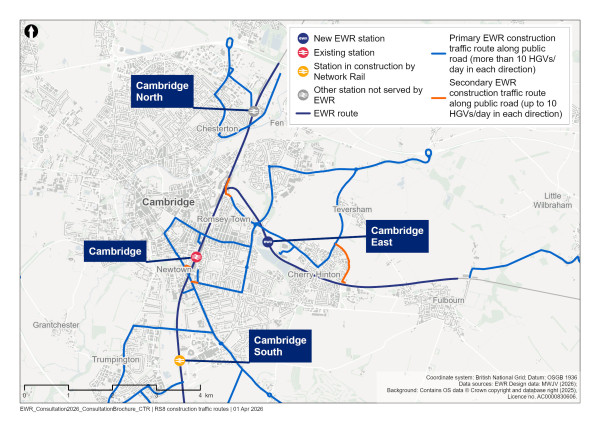
Figure 16: Map showing sample indicative plan for construction routes in the Cambridge area. Maps for all route sections are available at eastwestrail.co.uk/consultation2026
Construction of a new railway
Whilst detailed planning of construction activities will be carried out once contractors are appointed, in general, we anticipate the construction of the route to follow the sequence below:
Early-stage surveys
We would undertake comprehensive surveys of areas affected by the route from the early stages of the project to inform the developing design and to support assessment of construction impacts. These surveys would enable the identification of constraints and allow relevant consents, licences, and management plans to be agreed with key stakeholders.
Entry onto land
Working with landowners, we would take possession of land starting with priority areas. These would generally comprise locations requiring extensive site preparation and those needed to facilitate early activities such as habitat creation and archaeological investigations.
Utility works
We would undertake critical utility works at the earliest practicable opportunity. These works would typically be undertaken by statutory utility companies on behalf of EWR.
Early environmental works
In some locations, we would look to create new habitats and other environmental features before the start of construction.
Site clearance and enabling works
Once sites are secured, and all pre‑construction environmental mitigation measures are in place, we would undertake general site clearance. This would facilitate the establishment of construction compounds interconnected by a network of temporary service roads.
These service roads would provide a continuous access corridor alongside the proposed cuttings and embankments of the new railway. They would facilitate the movement of heavy goods vehicles (HGVs), articulated dump trucks (ADTs), and where appropriate, the workforce, plant and equipment.
The construction and use of these temporary service roads would enable controlled access of vehicles from the public highway, significantly reducing construction traffic on local roads and the associated impacts on local communities.
Earthworks construction
Following establishment of compounds and access infrastructure, we would commence main earthworks construction. This would include excavation of cuttings, segregation, handling and transportation of large volumes of earthwork materials, and formation of embankments. The temporary service road network would provide an efficient means of transporting the substantial volumes of earthworks material required for scheme construction. Cuttings and embankments would form the primary supporting structures for the new EWR railway.
Structures, tunnels and stations
Concurrent with the major earthworks, we would begin the construction of critical structures and stations. This would include major viaducts such as the A6 Paula Radcliffe Way viaduct, the A1 Great North Road viaduct, and the Tempsford station viaducts, as well as the proposed tunnels at Bourn and Chapel Hill and multiple new highway bridges.
Track and rail systems installation
The installation of the track and rail systems would then proceed across multiple sections of the route. A central East Coast Main Line logistics hub would be established near Tempsford to facilitate the delivery and distribution of bulk materials, including ballast, sleepers and track, primarily by rail.
Systems integration, testing and commissioning
Once the track and rail systems, including overhead line equipment and signalling, are installed and commissioned, we would undertake final testing of trains and integrated systems prior to entry into service.
Construction impacting the existing railway
Major construction and enhancement works would be required at and around a number of existing stations along the route, in particular at Bletchley, Bedford and Cambridge.
These works would be planned and carried out in close collaboration with Network Rail and the relevant station operators to ensure the continued safe operation of the railway, and to minimise inconvenience to passengers.
In addition to works to existing stations, numerous interventions would be required on the existing operational railway. These would include:
-
The installation of new passing loops and track connections
-
Construction of new sidings and stations
-
Delivery of new bridge structures
-
Enhancements to existing track, overhead line equipment and power supply infrastructure
Management of construction impacts
We understand that successful delivery of the new railway is dependent on working with people, businesses and communities, and protecting the environment that would be impacted by construction. We take our responsibility of managing construction impacts very seriously. We will produce a Code of Construction Practice (CoCP) and a range of other management plans which will set out details of the measures we would take to avoid or manage these impacts.
The CoCP will provide a consistent approach to managing the impacts of construction on communities and the environment. It will include best practice methods for communication with communities, providing a rigorous complaints procedure and making sure the skilled personnel are in place to manage community interfaces, dealing with any concerns raised efficiently.
Some examples of the measures we would take to avoid or manage potential impacts have been provided in Chapter 20. This includes the likely measures that would help to reduce the impact of construction on communities and environment.
We’re continuing to develop these measures, alongside other associated control plans through engagement with local authorities and relevant stakeholders prior to the DCO submission and these plans will be submitted as part of the application for the DCO.
11. Route-wide matters
This chapter provides information on the following topics, which are relevant to the whole route:
-
Electrifying the railway
-
Selection of depots
-
Utilities
Electrifying the railway
In line with the government’s commitment to decarbonisation and our ambition for a net‑zero carbon passenger railway, we propose to electrify the railway through the use of overhead lines which would provide power to the trains. We confirmed in November 2025 that we’ve decided to use a system known as ‘discontinuous electrification’.
Discontinuous electrification would mean overhead lines would only need to be installed along some sections of the route, meaning less construction would be required. Passenger trains would be powered by onboard batteries along other sections. This approach provides a lower cost solution to delivering the EWR benefits than full electrification at this time.
The system is designed to ensure that trains have enough power to complete their journeys if, for example, there are delays to the service or there is a power outage in a section of the route. It also means trains can keep operating if something unexpected happens on the line, such as a short power cut, because they can switch to using their onboard batteries.
The image below indicates the sections of the route where we’re currently considering overhead electrification.
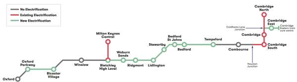
Figure 17: Diagram indicating sections of the route where we are considering electrification
Overhead line electrification
On the sections where electrification is to be provided, we would install a network of wires above the tracks to supply electric power to the trains. These wires would be supported by masts parallel to the railway.
Our designs would not preclude full electrification across the route in the future. For example, we’re designing new bridges with decks that are high enough for overhead lines to be installed underneath at a later date if required. We’ve also identified land for potential utility diversions on sections of the route which may not be electrified and are continuing to explore whether these are still required.
We’re currently proposing to electrify the railway between:
-
Oxford Parkway and Bicester Village
-
Bletchley and Tempsford
-
Cambridge (Coldhams Lane Junction) and Cambridge Eastern train care centre
Overhead line equipment may need to extend for a short distance beyond some stations to enable trains to switch between power from the overhead lines and the onboard batteries. Tracks within train depots would also be electrified so that train batteries could be charged overnight.
The Shepreth branch line, in the Comberton to Shelford route section, the West Coast Main Line and West Anglia Main Line are already electrified.
Some diesel passenger services would operate on some sections of the route between Oxford, Bletchley and Bedford during earlier years. This is until overhead line installation across the project is complete, enabling us to operate battery electric trains.
When battery electric trains are operating, it would not preclude some diesel trains using the EWR route operated by other passenger and freight operators.
Supplying power to East West Rail
To electrify the railway, power would be needed from the National Grid and electricity distribution network operators. We’re engaging with them to assess the best ways of connecting EWR to the grid. Cables would feed substations situated next to the railway, which would then distribute power along the railway via the overhead lines. These substations would be located within secure compounds, with vehicle access for emergencies and maintenance.
We aim to use existing infrastructure wherever possible, but there would be a need for new utility connections in some areas. We’re still considering the best locations and designs for these connections within each of the route sections.
Selection of depots
A reliable, punctual and high quality railway requires well maintained trains. Itis important that we provide quality facilities to stable and maintain the trains. This includes depots which support an efficient train maintenance programme by enabling routine checks and cleaning of trains to keep them reliable for service.
These facilities need to work together across EWR to minimise empty train movements and make sure that trains are as close to their origin as possible at the start of service each day. We plan to have a central depot supported by facilities at either end of the route.
We are proposing the following facilities along the route:
-
A train maintenance depot to the west of Bletchley near Whaddon Road. This would be used for the stabling, inspection, cleaning and maintenance of trains and would be the primary location where trains are parked and fully serviced.
-
A Cambridge Eastern train care centre. This would provide a facility for routine servicing and cleaning, reducing the distance travelled by empty trains.
-
Sidings along the route that would provide additional places for trains to be stabled when not in service. These are proposed to be located in Bedford (reuse of existing Jowett sidings) and Oxford (use of existing sidings in the Oxford area, in addition to the proposed turnback siding at Oxford Parkway). We are still exploring an alternative to Jowett by potentially integrating this into our Stewartby station proposals.
More information on these facilities is set out in the relevant route section chapters of this consultation brochure.
In addition to the depots and sidings above, we’re proposing a maintenance delivery unit (MDU) facility at Cambridge north, which is required for the storage of spare parts, tools and equipment to facilitate a quick response to technical issues on the railway. You can find more information about the MDU in the Cambridge route section chapter of this consultation brochure.
In selecting the proposed locations for the train maintenance depot and train care centre we’ve carried out a comprehensive option selection process using a range of criteria known as Assessment Factors. Details of the outcomes of this process are provided in the relevant route section chapters. More information about the Assessment Factors is set out in the Assessment Factors factsheet which is available on our website at eastwestrail.co.uk/consultation2026
Utilities
To construct the railway, a range of existing underground and overhead services, such as electricity, gas, water, sewers and communications cables, would need to be protected or relocated. New utility supplies would also be required to support construction activities and new infrastructure across the route.
We’re working closely with utility companies to agree what works are required. This includes identifying routes for diverted utilities, understanding how the work would be undertaken, how sites would be accessed and how we’ll minimise disruption.
Many proposals for works to utilities are shown on the plans and drawings included as part of this consultation. As we continue to discuss work with utility companies and refine proposals, the amount of land we’ve identified on these plans will be refined.
We’ve also identified areas that remain subject to further utilities investigation. These are illustrated by a red star on plans and drawings. Once we’ve undertaken further design work with the utility companies, we’ll provide an update.
The extent of works required, and the land we may need either temporarily or permanently, will be determined following further investigation.
We’ll continue to engage with landowners where land is needed to allow work to utilities.
All required utilities works will be included as part of our DCO application.
12. Oxford to Bletchley
East West Rail (EWR) would use the existing railway between Oxford, Bletchley and Milton Keynes on this 48km (30 mile) route section. This route section starts at the A423 Southern Bypass Road, Oxford and ends at Saxon Street, Bletchley, and also includes the section of railway between Bletchley and Milton Keynes. We would carry out upgrade works to the railway to enable the increased number of passenger services and freight to operate from Oxford to Cambridge.
This chapter presents our updated proposals for the Oxford to Bletchley route section.
In this route section we’re proposing the overhead electrification of the railway between Oxford Parkway and Bicester Village, and also from Bletchley running east to support the electrification of the Marston Vale Line.
As part of this consultation, we are seeking your views in particular on our proposals for:
-
An underpass at London Road, Bicester
-
A Bletchley West train maintenance depot and passing loops
-
An eastern entrance for Bletchley station
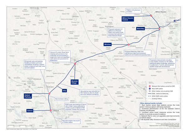
Figure 18: Map of the planned route of the project from Oxford to Bletchley
Oxford
Our latest proposals
EWR services would start at Oxford station, before heading north on the existing railway.
At our previous consultation, we said operational changes and track modifications were likely to be required to accommodate the full EWR timetable. We also said alterations may be needed at Oxford station to accommodate increased passenger numbers, as this station is already facing capacity constraints.
Network Rail will be carrying out a range of upgrades and improvements to the station and the rail network in the Oxford area to increase capacity and improve performance.
Network Rail is also proposing to reopen the Cowley Branch Line for passenger services, which would free up platform capacity at Oxford station and allow trains on EWR services to terminate at the station. EWR would not need to carry out any further works at the station.
We propose to construct a new northbound passing loop near Kennington, to allow faster northbound freight trains south of Oxford to wait for an available train path through Oxford station to then use EWR towards Bletchley.
We’re engaging with the wider railway industry to review stabling options for a small number of EWR trains in the Oxford area. This is needed to support efficient and reliable operation of the morning EWR services from Oxford.
Oxford Parkway
Our latest proposals
With the expected increase in passenger demand, we’re working closely with the current train operator and with stakeholders involved in nearby developments, including the proposed new Oxford United stadium near Kidlington, to look at station improvements that meet the needs of all passengers.
Within the station forecourt, there would be a new active travel hub with cycle parking. An improved pedestrian access route between the station building and the existing park and ride terminal would be provided. To enhance the safety of people walking, wheeling or cycling, we’re working with stakeholders to improve the crossing facilities at the station access junction with Oxford Road.
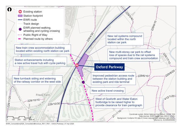
Figure 19: Map of Oxford Parkway
Within the existing north station car park, a new workforce accommodation building would be constructed. This would be a multi‑storey building providing welfare facilities. Provision has also been made within the existing north station car park for a rail systems compound. This would house traction power equipment, essential for supplying electricity to the proposed overhead wires, and would serve as a base for track maintenance to support both routine and emergency repair works.
This location for the rail systems compound is one of several options being considered for feeder stations along this section of the route. The final location of the traction power compound will be confirmed through discussions with utility providers.
To offset the loss of existing parking resulting from the workforce accommodation building and rail systems compound, a new multi‑storey car park is proposed within the existing north station car park.
As presented at our previous consultation, several high voltage overhead power cables would need to be diverted in the vicinity of Oxford Parkway station to provide the necessary clearance for the overhead lines that would be installed to electrify the railway. We would also need to raise the height of the West of Gosford and Water Eaton footbridge (OXD47D) to provide the required electrical clearances.
Just south of Oxford Parkway station, where the EWR route passes the now closed North Oxford Golf Club, we now propose to widen the railway corridor on the west side. This would enable us to construct a turnback siding which may be required if EWR opens before the separate Cowley project is completed, allowing trains travelling towards Oxford to reverse direction. We are engaging with stakeholders to align our plans with future proposals for residential development and active travel routes in this area.
The area between the existing railway and the A34 contains woodland, which is partially overlapped by the western extent of the turnback siding. In finalising the proposals for the turnback, we would seek to minimise the extent of removal of priority habitat and mitigate any loss through landscape planting. To mitigate any potential flood risk associated with the introduction of new railway infrastructure for the turnback, a drainage pond would be created adjacent to the railway and Oxford Road, within the northern extent of the now closed North Oxford Golf Club.
Approach to construction
To support the planned works to Oxford Parkway station, a satellite compound would be built within the Network Rail boundary near the station car park. Access would be via the existing station access route from Oxford Road.
To build the widened railway corridor south of Oxford Parkway required for the proposed turnback siding, another satellite compound is proposed to the west of the existing railway and north of the current Pear Tree park‑and‑ride site. Access to the compound would be either from the A44, via the services access road, or through a new direct access point from the A44.
Islip
Our latest proposals
The EWR route would continue north‑east from Oxford Parkway to Islip. As presented at our previous consultation, we do not plan for EWR services to call at Islip and no changes to this station are required.
A passing loop would be constructed to the north‑east of Islip to serve the westbound track to the south of the railway, and would allow faster trains to overtake slower services. This passing loop has been extended by 400 metres since our previous consultation, to allow for faster and more efficient overtaking. It sits within a flood zone and would be designed to manage any flood risks, including the provision of a flood compensation area within Gallos Brook and a drainage pond to the east of it. Woodland and grassland habitat would be planted around this drainage pond to provide environmental enhancements. The southern extent of the passing loop would be lined by hedgerows to provide visual screening.
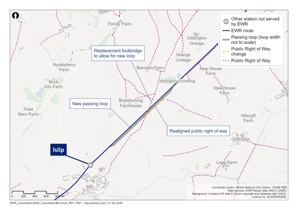
Figure 20: Map of passing loops at Islip
There is an area of priority habitat associated with a tributary of Gallos Brook that extends either side of the existing railway. Part of this habitat could be priority floodplain grazing marsh, which is classified as potentially irreplaceable habitat. As a precaution, we have refined the position of the new passing loop and supporting infrastructure to avoid the area of habitat as far as possible, and we’ll carry out survey work to confirm its status and condition. We are also proposing to provide mitigation planting to create floodplain grazing marsh or wetland meadow. Our current proposals allow for this planting on the south side of the railway, either side of Gallos Brook, to a point where an existing farm access track intersects Gallos Brook.
To accommodate routine and emergency access to the loop from the highway, a new track access point and permanent compound is proposed at the east end of the Islip station car park. This compound would be lined by hedgerows along the west and east borders, with landscape planting provided along the southern extent of the compound, which would offer some visual screening. To allow large vehicles to access this compound, it would be necessary to widen the junction at the Islip station car park approach road and Bletchingdon Road.
Approach to construction
Construction of the new Islip passing loop would be supported by two satellite compounds. The first compound would be located north of the existing station car park. Construction traffic would use the existing station access route.
The second compound would be situated further north and would be accessed via the existing accommodation track from Middle Street.
Bicester
What we presented at our previous consultation
We proposed closing the level crossing at London Road, Bicester. This was based on our assessment of the impact of four trains on EWR services per hour in each direction passing over the crossing, in addition to existing train services. This would result in the barriers at London Road level crossing being down for at least 32 minutes every hour, leading to:
-
Unacceptable waiting times
-
Increased congestion, with queuing expected to back up to Market Square and the A41/A4421 roundabout
-
The potential for misuse of the crossing, due to the increased waiting times, raising safety concerns, such as increased risk of injuries and fatalities
We presented two options to provide an accessible replacement crossing for walking, wheeling and cycling to make sure people can still cross the railway safely and easily. These options were:
-
Option 1a – a footbridge with ramps and stairs
-
Option 1b – an underpass for non‑motorised users
For both options, road traffic would be re‑routed via existing roads, with accompanying upgrades to local roads and junctions to mitigate journey times.
What you told us
Of the two options presented at the previous consultation, the majority of you favoured an underpass. You wanted a safe, accessible and well‑connected option for people walking, wheeling and cycling. Many of you noted an underpass would have less visual impact than a footbridge and would provide a more direct and accessible active travel route.
Many of you indicated that neither design option fully met the needs of the local community, and there was a strong preference to maintain vehicle access across the railway.
Taking account of this feedback, we announced in the You Said, We Did Autumn Update that we had identified a further option for a revised underpass design which includes a single‑lane road that could be used by vehicles, alongside a protected active travel corridor for pedestrians and cyclists. We explained that we would be engaging with local stakeholders on this option before presenting a final proposal in 2026. Following this engagement, we have confirmed that the underpass option has been included in our designs subject to third party funding contributions.
Our latest proposals
The updated train service specification we’re considering introduces more frequent and longer trains than presented at our previous consultation. This would further increase the barrier down time, exacerbating safety issues, were the crossing to remain open. The closure of the level crossing therefore remains necessary.
We propose to close the crossing and build an underpass which includes a single‑ lane road that could be used by vehicles no more than 2.1 metres high, alongside a protected active travel corridor for walking, wheeling and cycling. This underpass would be subject to third party funding. Traffic signals and vehicle height barriers would be installed on the approach ramps to allow vehicles to travel through the underpass safely in both directions.
We’re proposing the single‑lane solution to avoid excessive impacts to residential properties along London Road. We considered a two‑lane road, but this would require a wider and deeper underpass which would need more land to be acquired to accommodate longer ramps, directly impacting properties nearby.
The alignment of the underpass has been updated so that the north approach ramp would tie into the existing Station Approach/London Road junction rather than extending along Station Approach towards the station. While this updated underpass alignment requires the acquisition of land occupied by businesses directly north and south of the existing level crossing, it provides a more direct route towards Market Square for both pedestrians and vehicles. For cyclists, this improved alignment better complements the cycleway between the A41/Ploughley Road and London Road/Launton Road junction planned by Oxfordshire County Council. Access to Alchester Terrace would be maintained via a new road link across the site currently occupied by the petrol filling station.
In addition to increasing the footprint of the project for the proposed underpass, we’re including measures to enhance the public realm around Bicester Village station, including:
-
A new active travel hub to the south of the railway, including cycle parking
-
An enhanced bus stop and private car pick up and drop off area
-
A sloped embankment along one side of the underpass approach ramps, creating a more open underpass environment with natural light
-
Public space and walkways around the retained Grade II listed building directly north of the existing level crossing
-
A direct walkway from the station across the underpass towards Langford Village
As the vehicle underpass would require a height restriction, there is a risk that vehicles may strike the underside of the structure. Height and width restriction infrastructure would be installed at the underpass approaches to prevent oversized vehicles from accessing the ramps. The station pick up and drop off areas would be positioned to allow oversized vehicles to safely turn around and divert along other roads.
Further highway restrictions may be needed to reduce the risk of oversized vehicles attempting to use the underpass and we’re engaging with relevant stakeholders, including local authorities and Network Rail, so that the crossing is safe for all users.
The proposed underpass would require the acquisition of some land along London Road. We’ve already informed those affected and we’re continuing to assess how much land is required. Provision of an underpass would make journey times for people walking, wheeling or cycling quicker than the footbridge option we previously consulted on.
Initial traffic modelling predicts that queuing for vehicles using the proposed single‑ lane vehicle underpass would be broadly similar to that experienced at the current level crossing. While larger vehicles such as buses and HGVs would still be diverted, the addition of the road underpass would maintain access for smaller vehicles, limiting overall traffic increases on the diversion routes compared to previous proposals.
This limiting in overall traffic volumes along the diversion routes also removes the need for multiple remote junction upgrades that may have been required for other proposals. Current traffic modelling indicates that only a single junction upgrade would be required with the underpass option. Further traffic modelling, and wider environmental assessments are underway to refine the details of the junction improvement proposal, and we’ll continue to work closely with the local highway authority as the design progresses.
We presented these proposals as part of Design Update Sessions held in February this year. Feedback received at these events and in response to this consultation will help us refine our plans.
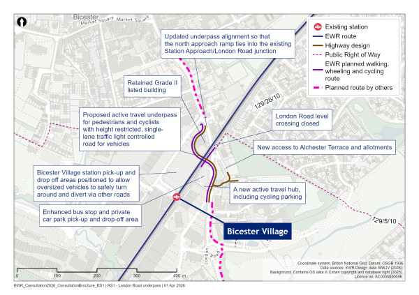
Figure 21: Map of the underpass at London Road, Bicester
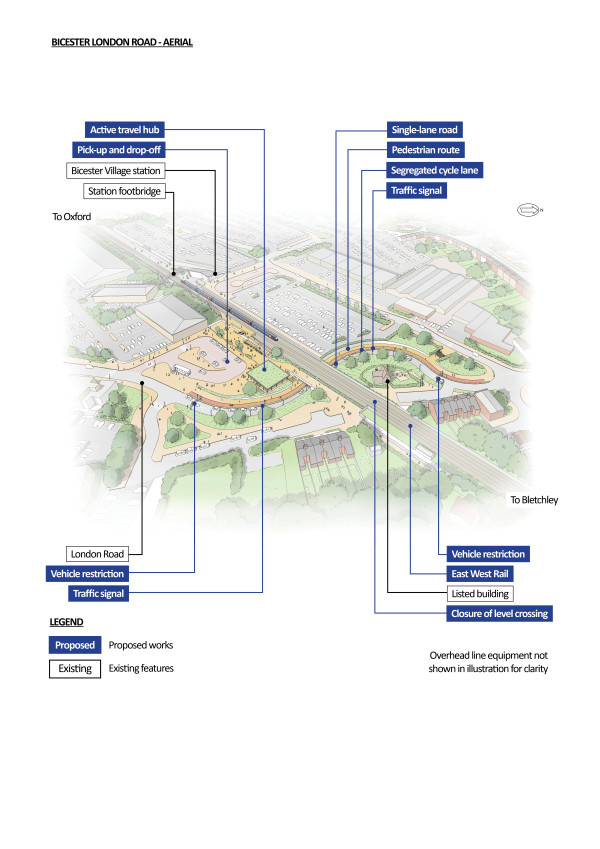
Figure 22: An indicative aerial illustration of the underpass at London Road, Bicester
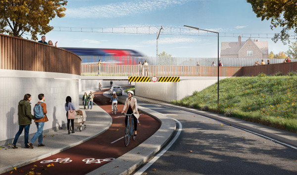
Figure 23: An indicative illustration of the underpass at London Road, Bicester looking north-west towards the railway line
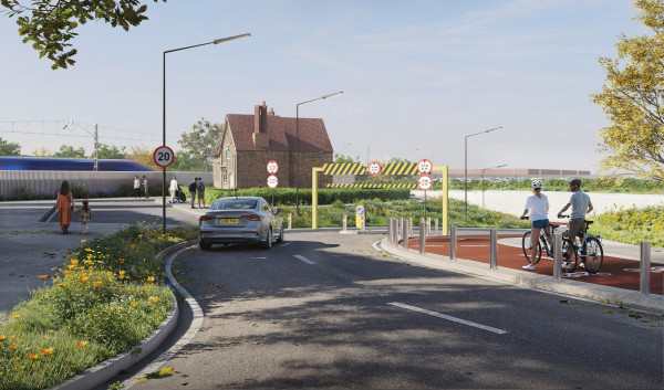
Figure 24: An indicative illustration of the approach to the underpass at London Road, Bicester, viewed from the junction of London Road and Station Approach
Approach to construction
Due to the nature of works at Bicester and the constrained nature of the site, two separate construction compounds are proposed.
The main compound, positioned adjacent to the A41, would house welfare and office facilities as well as storage areas for materials and plant. Access would be via the London Road/Neunkirchen Way roundabout.
A second satellite compound would be located at the worksite, likely within the existing car park areas to the north and south of the operational railway. Access would be via London Road.
While the project would maximise construction during normal working hours, the proximity to the operational railway means some major works would need to be undertaken during night‑time or on weekends. An extended railway closure, involving 24‑hour working, is anticipated to complete the construction of the underpass beneath the tracks.
Share your feedback
As part of this consultation, we would like to hear your feedback on our revised underpass proposals for London Road level crossing.
You can complete our online feedback form or find details of other ways to respond to our consultation in the How to respond to this consultation chapter.
Middle Claydon and Verney Junction
Our latest proposals
At our previous consultation, we proposed a new westbound passing loop at Middle Claydon to allow faster trains to overtake slower trains. We have undertaken further operational analysis which took account of the introduction of additional passing loops west of Bletchley, meaning the westbound passing loop at Middle Claydon is no longer required. Therefore, the passing loop has been removed from our proposals.
As noted in the section above, Electrifying the railway, we’ve retained land for potential utility diversions on sections of the route which may not be electrified and are continuing to explore whether these are still required. Accordingly, we are still reviewing the need to divert a number of high voltage power cables which cross the railway in the Verney Junction and Winslow area.
Winslow
Our latest proposals
Winslow station is an EWR station, built by Network Rail to accommodate new services between Oxford and Milton Keynes. At our last consultation we explained that the station was designed and constructed based on earlier passenger demand requirements but did not preclude later expansion.
Following updated demand analysis based on more frequent Oxford to Cambridge services of up to five carriages that would serve the routes, we’re now considering extending the station platforms by 24 metres to the west. We would propose undertaking this work without disrupting passenger train services using the station. This is due to the possible requirement for five‑carriage trains to meet the anticipated increase in demand. We’re also proposing improvements to the highway crossing outside the station at Great Horwood Road to improve active travel connections in the area.
Bletchley West passing loops and train maintenance depot
We’re proposing to construct a train maintenance depot west of Bletchley on the north side of the EWR main line, as well as westbound and eastbound passing loops in the same area.
Well maintained trains are essential for a safe and reliable railway. A train maintenance depot brings together all the functions needed to maintain, service and house trains in one place. It therefore requires a large area of land, incorporating train stabling sidings, a large maintenance workshop building, train servicing equipment and associated infrastructure to support both day‑to‑day and specialist maintenance activities.
The train maintenance depot would be a fenced compound and would include the following facilities:
-
Stabling for up to 20 trains of up to five‑carriages, each up to 120 metres in length
-
A maintenance workshop sized to accommodate multiple trains simultaneously
-
Ancillary infrastructure, including a traction power substation, train wash, automatic vehicle inspection system, controlled emission toilet facilities, sand replenishment facilities with associated plant rooms, storage building and recyclable waste handling areas
-
Operational roads and compounds to support HGV access and materials deliveries
-
Office and welfare facilities, car parking for staff and visitors and a security gatehouse to manage access
The passing loops, which are additional sections of track laid in parallel to the main line, would allow faster trains to overtake slower services, providing flexibility and reliability of service. One of these loops would provide access to the train maintenance depot.
What we presented at our previous consultation
At our previous consultation, we said that, to enable the smooth and reliable operation of EWR services, we would need locations to stable and maintain trains when they are not in service. This would include a train maintenance depot, a smaller satellite train care centre, and sidings. We presented broad search areas that were being considered for these facilities which covered areas near Bicester, west of Bletchley, Bedford, north of the proposed Tempsford station and west of the proposed Cambourne station.
We also explained that we would need passing loops at various locations along the EWR line to enable faster and more reliable services. We presented proposals for passing loops in Islip, Middle Claydon, between Aspley Guise and Kempston Hardwick, Colesden, Cambourne and at Hauxton junction.
What you told us
A small number of you expressed concern about the community impacts of the potential depot locations, including disruption to local communities and loss of farmland. Potential harm to wildlife was also raised as an issue. You suggested that depots should be located away from residential areas and sensitive ecological areas.
Some of you suggested that existing facilities should be reused or expanded, such as those in Bletchley and Northampton, rather than creating new ones on greenfield sites. A small number of you also raised concern about land for depots being included within the safeguarding boundary, and suggested we focus on areas immediately around stations rather than extending into employment or housing land.
Some of you recognised the importance of sufficient track capacity and passing loops to accommodate freight services. However, the visual and noise impacts of the passing loops and associated structures was highlighted by some of you, with requests for screening measures such as tree planting and sound barriers.
How we identified the preferred location
Since our previous consultation, we have undertaken a detailed review of options to determine the preferred location for the train maintenance depot.
The option selection process started with the identification of 35 potential sites along or near the route that were big enough to accommodate a train maintenance depot.
This included considering the expansion or reuse of existing depot sites. An indicative depot layout was then used to determine the feasibility of these sites as a location for a train maintenance depot. We considered the following factors:
-
Whether the site would be large enough to accommodate a train maintenance depot and could be connected to the nearby railway in a cost‑effective way
-
If the location was suitable to minimise empty train mileage from key stations along EWR
-
If there were likely to be direct impacts to sensitive designated environmental features resulting from the location of the train maintenance depot
-
If the surrounding road network was suitable for site access
-
Whether the site was located in an area identified for development in the local plan or could impact existing or emerging planning applications
This review resulted in five locations being shortlisted
We carried out a detailed assessment of the relative advantages and disadvantages of the five potential locations using a range of relevant criteria known as Assessment Factors. You can learn more about these Assessment Factors and how they are used to support decisions on our proposals in our factsheet at eastwestrail.co.uk/consultation2026
The outcome of the assessment was that the site west of Whaddon Road was identified as the preferred location for the train maintenance depot.
The main factors that support the decision to locate the train maintenance depot at Bletchley West are summarised below.
-
Railway operations ‑ The proposed site would enable the internal layout of the train maintenance depot to be optimised compared to other sites. The site could accommodate a layout that would reduce the extent of reversing moves required. The proposed site was less constrained than the others and would therefore provide flexibility to accommodate additional sidings if required. Existing facilities, such as those in Bletchley and Northampton, were found not to have the capacity.
-
Construction and delivery ‑ The proposed site performed better than other options due to more access routes into the area. It also presented fewer interfaces with existing infrastructure, such as utilities.
-
Environment ‑ Other sites were found to have greater impacts on environmental and ecological receptors. Some of the options would have impacts on heritage assets such as scheduled monuments or present a greater flood risk. On balance, the proposed site was found to perform better than other options as the impacts could be more easily mitigated through screening and landscaping.
-
Other developments ‑ The option selection process considered other proposed developments. While some other sites were found to conflict with planned development, there are no committed developments or current planning applications for the proposed site, although it was recognised that the site is adjacent to Taylor Wimpey’s development at Salden.
A technical report describing the option section process is available on the EWR website at eastwestrail.co.uk/consultation2026
The option selection process was undertaken based on a single typical depot layout, with the stabling and workshop buildings positioned towards the eastern end of the site. Our next phase of design development we’ll be looking at how the depot facilities will be laid out at this location, which could include positioning facilities towards the western end of the site. This will be refined prior to the submission of the Development Consent Order.
We presented these proposals as part of Design Update Sessions held in January this year. Feedback received at these events and in response to this consultation will help us refine our plans for the Bletchley West train maintenance depot. The draft Order Limits boundary covers all options being considered and will ultimately reduce in size, for example depending on the final train service level.
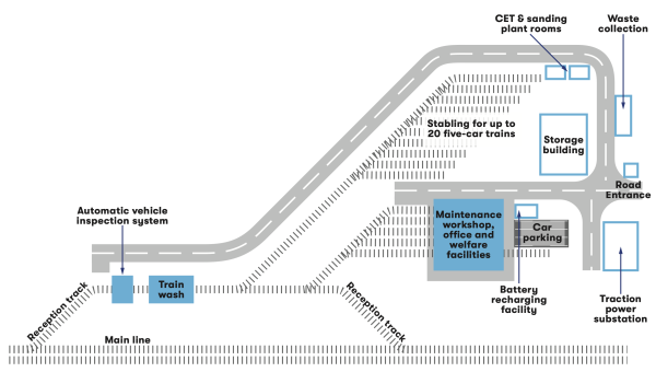
Figure 25: A diagrammatic layout of the Bletchley West train maintenance depot
Passing loops
Further development of the timetable and freight strategy since our previous consultation has highlighted the need to provide passing loops near Bletchley. This would enable freight trains to align with available time slots on the West Coast Main Line (WCML).
We’re proposing the construction of two passing loops located in the vicinity of the train maintenance depot, a westbound loop and an eastbound loop, to provide freight holding capacity. The new section of track for the proposed westbound loop would be located immediately south of the existing tracks passing under Whaddon Road. The proposed eastbound loop would be located to the north of the existing tracks and to the west of Whaddon Road.
These loops would run alongside the train maintenance depot site, adjacent to the existing railway creating a wider rail corridor with four tracks in the area around the depot. The loop on the north side of the railway (eastbound loop) would also connect to the reception track into the depot.
Alterations to several bridges may be required to accommodate the train maintenance depot and the loops. Bridges affected could include Swan’s Way/Whaddon Road bridge, Salden Road bridge, Newton Approach Road bridge, all of which would cross over the railway, and Trenches footpath bridge, which would pass under the railway.
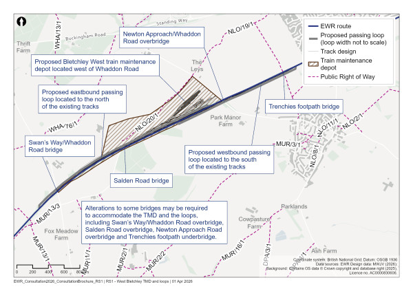
Figure 26: Map of the Bletchley West train maintenance depot and passing loops
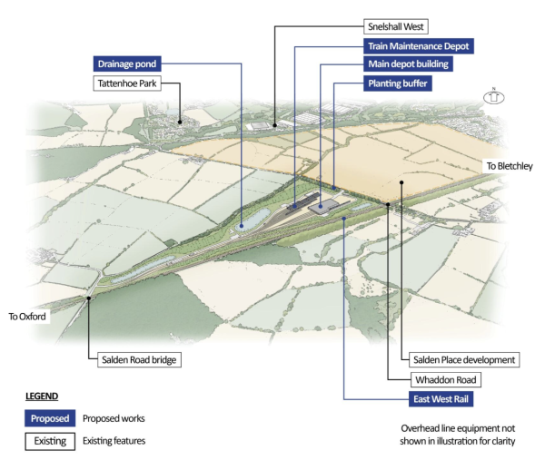
Figure 27: An indicative aerial illustration of the Bletchley West train maintenance depot and passing loops
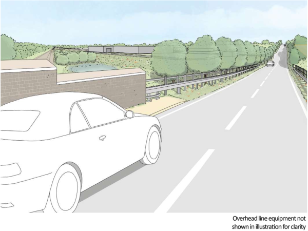
Figure 28: An indicative illustration of the Bletchley West train maintenance depot
Approach to construction
Provision of the proposed train maintenance depot and associated passing loops would require three construction compounds.
The main compound would be located north of the train maintenance depot site, adjacent to Whaddon Road, with construction traffic primarily accessing Whaddon Road via the A421. This would also support any works required to the Newton Approach/Whaddon Road bridge.
A satellite construction compound may be required to support any works required to the Salden Lane overbridge and would be located north of the railway, with access through the train maintenance depot site.
Another satellite construction compound may be required to support any works required to the existing Swan’s Way/Whaddon Road overbridge. Access would be from Swan’s Way via the A421.
The location of these compounds is shown on the plans which can be found at eastwestrail.co.uk/consultation2026
Construction traffic routes serving these construction compounds are being evaluated further and these would route construction traffic to and from the A421 and to minimise their impacts on the local community, where possible. Construction traffic would be mandated to use the designated routes.
Share your feedback
As part of this consultation, we would like to hear your feedback on our proposals for a train maintenance depot and passing loops at Bletchley West.
You can complete our online feedback form or find details of other ways to respond to our consultation in the How to respond to this consultation chapter.
Bletchley station and eastern entrance
What we presented at our previous consultation
At our previous consultation we explained that we are working with local authorities and stakeholders to improve Bletchley station’s connectivity with the surrounding community and enhance the public realm. As part of our work with Milton Keynes City Council, we said we were evaluating the strategic and economic case for a new eastern entrance to the station at Bletchley.
What you told us
In response, many of you suggested an eastern entrance for Bletchley station to improve access for communities to the east of the railway, provide a more direct link to the bus station, and to enhance connectivity with the town centre and Queensway. The potential economic benefits of an eastern entrance, including better access to local businesses and the Brunel Shopping Centre, were also highlighted.
For a detailed overview of feedback received at our last consultation, please see our You Said, We Did Autumn Update.
Our latest proposals
We’re proposing to include an eastern entrance for Bletchley station within our design. The new station entrance would improve connectivity to the town and surrounding area, make it easier for people to access the railway and local amenities, and support wider regeneration aspirations. A new eastern entrance would be conditional on securing third party funding.
Across the rest of Bletchley station, we’re proposing to carry out a range of capacity enhancements to enable the station to meet anticipated future demand. At the west of the station, a new larger ticket hall is proposed to replace the existing gate line. The new west ticket hall would be accessed directly from an enhanced west station forecourt, including more cycle parking, blue badge parking bays, a new bus drop off and new active travel routes and crossing points.
Within the station, a new accessible footbridge is proposed to the south of the existing footbridge including lifts and stairs down to each of the six existing low‑level platforms. The new structure would link directly to platform 7 at the viaduct level with a new mezzanine level beneath the existing viaduct providing access to platform 8 and the newly proposed eastern entrance.
The eastern entrance would provide access to the station via Saxon Street and allow passengers to reach the platforms via an accessible footbridge, lifts and stairs. Combined with the proposed enhancements across the rest of the station this would bring significant benefits to users of the railway, especially passengers accessing the station from the town centre. It would:
-
Improve connectivity to the town and provide a gateway to destinations like Bletchley Park and Stadium MK, by reducing walking distance between EWR platforms and the town centre by 600 metres
-
Enabling access to rail services for residents affected by the closure of Fenny Stratford station
-
Support the local authority’s wider regeneration plans between the station and the town centre, including road network upgrades and redevelopment of the Brunel shopping centre
Across the rest of Bletchley station, we’re proposing to carry out a range of capacity enhancements to enable the station to meet anticipated future demand. At the west of the station, a new larger ticket hall is proposed to replace the existing gate line.
The new west ticket hall would be accessed directly from an enhanced west station forecourt, including more cycle parking, blue badge parking bays, a new bus drop off and new active travel routes and crossing points.
To improve accessibility, we propose to provide a new ramp at the staired access to the station on Buckingham Road. Lighting will be improved beneath the railway bridge. Outside the existing western forecourt, we propose a new toucan crossing across Sherwood Drive.
The changes would transform the station into a key interchange hub enabling passengers to connect between EWR, the WCML, and local services between Bletchley and Milton Keynes.
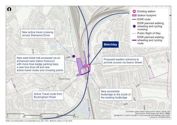
Figure 29: Map of Bletchley station
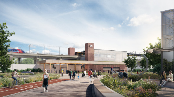
Figure 30: An indicative illustration of Bletchley station
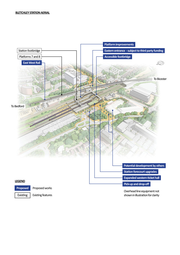
Figure 31: An indicative aerial illustration of Bletchley station
Approach to construction
Construction works at Bletchley station would be supported by two compounds located on either side of the railway. The main compound would be situated to the west of the station on undeveloped land and support the new western entrance and footbridge construction. Construction traffic would access the site from Saxon Street (B4034) via Sherwood Drive. A satellite compound would be located to the east, making use of the area adjacent to and beneath the current rail viaduct. Access would be directly from Saxon Street (B4034).
Share your feedback
As part of this consultation, we would like to hear your feedback on our proposal for an eastern entrance for Bletchley station.
You can complete our online feedback form or find details of other ways to respond to our consultation in the How to respond to this consultation chapter.
Milton Keynes Central station
Our latest proposals
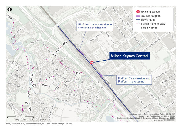
Figure 32: Map of Milton Keynes Central station
Due to an increase in anticipated demand from the planned Universal Entertainment Resort Complex near Bedford, we’re now considering operating EWR trains of up to five carriages (120 metres long). The only platform at Milton Keynes with timetabling capacity for EWR trains is Platform 2A, which is 20 metres shorter than would be needed.
Therefore, we are now proposing platform extension works to Platform 2A. We currently plan to extend both the north and south ends of the platform. However ongoing design work may mean that only one end is extended. All works would be within the existing Network Rail boundary.
Approach to construction
The construction works would be supported by a satellite compound located within the Elder Gate car park, east of the station and adjacent to the existing track access point.
Other railway infrastructure
Traction power compounds
Between Oxford and Bletchley, we’re proposing two separate sections of overhead electrification in line with our discontinuous electrification strategy. The first would start from a point south of Oxford Parkway station adjacent to the recently closed Oxford North Golf Course and continue towards Bletchley to a point east of Bicester just past Bicester Road overbridge. The second section would begin at a point west of Bletchley and run east to support the electrification of the MVL.
To provide power to the overhead lines, we require a number of traction power feeder stations (a type of traction power compound) along the route which are connected to the National Grid via new utility connections. We also require a number of smaller switching compounds along the electrified sections to provide reliable power.
Our discussions with utility providers are ongoing so we have a number of sites we’re still considering. Once these discussions are concluded, we’ll be able to confirm the locations of these traction power compounds.
We have three possible locations for a traction power feeder station between Oxford Parkway and Steeple Claydon:
-
Oxford Parkway station— We have made provision for a site in the northern car park of Oxford Parkway station which we would anticipate connecting to the existing utility HV overhead power cables near Oxford Road
-
East of Bicester— A possible site could be located to the north of the railway and east of Bicester Road near Launton, which would have a connection to the existing utility sub‑station off Skimmingdish Lane
-
Steeple Claydon— At the previous consultation we identified options for new traction power feeder stations in the Steeple Claydon and Verney Junction areas with connections feeding from Quainton and East Claydon, respectively. We believe the connection to Quainton is still viable so are considering a traction power feeder station to the west of Addison Road, south of Steeple Claydon
We’ve made provision for a switching compound to the south of the railway just to the east of the M40 crossing point near Merton. The traction power feeder station sites identified at Oxford Parkway station and east of Bicester are also being considered as switching compounds in the event that they are not chosen as traction power feeder station compound locations.
We also have two options for a traction power feeder station in the Bletchley area:
-
A new traction power feeder station located between Bletchley station platform 8 and Princes Way, fed from the existing Network Rail Bletchley Super Depot on Water Eaton Road, Bletchley
-
A new traction power feeder station located at the existing Bletchley London Northwestern Railway depot, fed from the existing Bletchley utility sub‑station near Granby Court
This is where the Oxford to Bletchley route section ends. The railway would then transition to the Fenny Stratford to Kempston route section.
13. Fenny Stratford to Kempston
To provide you with details of our plans between Fenny Stratford and Kempston, we’ve set out this chapter differently to the other route sections. We start with an outline of our proposals, followed by an overview of how we’re approaching level crossings, stations and acceleration works. We’ve split this route section into five smaller sections and we cover each in turn, going into the detail. At the end of the chapter you’ll find a table summarising our proposals for all the level crossings within this route section.
East West Rail (EWR) would use the existing Marston Vale Line (MVL) between Bletchley and Bedford on this 23km (14 mile) route section. This starts at Saxon Street in Bletchley and ends at Ampthill Road in Kempston. This route section would be upgraded to provide four modern, well‑equipped stations at Woburn Sands, Ridgmont, Lidlington and Stewartby to replace the nine existing stations that date back to the 1840s. We would also make changes to existing level crossings and install overhead line electrification throughout this route section.
This chapter presents our updated proposals for the Fenny Stratford to Kempston route section. As part of this consultation, we’re seeking your views in particular on our proposals for:
-
Connectivity proposals for the new stations
-
The seven level crossings where our proposals have changed since our previous consultation
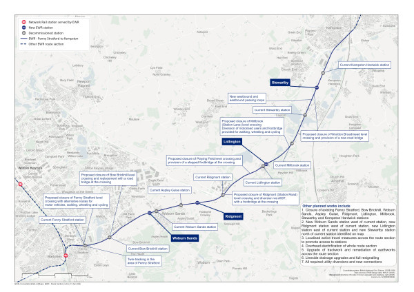
Figure 33: Map of the planned route of the project from Fenny Stratford to Kempston
In our You Said, We Did Autumn Update we explained how we’ve continued to shape our proposals for stations and services along the Marston Vale Line (MVL). Existing stations on the MVL are spaced an average of only 1.7 miles apart, have poor facilities and are among the least used stations in the country. They were designed and located to serve industry in the area over 150 years ago rather than supporting the growing communities we see today. There’s currently just one train an hour between stations, with long journey times resulting from the frequent stops.
To address these constraints, we would provide four modern, well‑equipped stations around the following areas:
-
Woburn Sands ‑ supporting the existing community and nearby developments including the South East Milton Keynes (SEMK) development and East of Wavendon Strategic Urban Expansion
-
Ridgmont ‑ serving Brogborough, Aspley Guise, Ridgmont, the M1 motorway and surrounding development opportunities
-
Lidlington ‑ supporting the village and the nearby Marston Valley development
-
Stewartby ‑ supporting Stewartby village and providing access to local developments including the new Universal Entertainment Resort Complex and the consented Stewartby Brickworks housing development
We explained the need to relocate new stations at Woburn Sands, Ridgmont, Lidlington and Stewartby in our You Said, We Did Autumn Update.
The proposed locations for the new stations avoid impacts on surrounding houses, businesses, greenspace, future developments and other land uses, while supporting the needs of current communities and future growth opportunities.
The new modern, accessible stations would not only support the planned provision of thousands of new homes across the region but also maximise the once in a lifetime opportunity arising from the new Universal Entertainment Resort Complex.
Fenny Stratford, Bow Brickhill, Aspley Guise, Millbrook and Kempston Hardwick stations would be closed, and we explain how we would support communities in these areas by investing in improved road and active travel connections to the new stations, while protecting the listed buildings connected to the existing stations for future community use where possible.
In line with our ambitions to offer benefits to communities along the route as early as possible, our plans for the Marston Vale Line would offer not only a more frequent and higher‑capacity service, but would also bring these benefits to the region earlier than previously envisaged. By changing our delivery approach, we’re proposing that the Marston Vale Line has new stations ahead of the full‑completion of the railway, and that train services could start operating higher frequency services ahead of the route‑wide service pattern.
What we presented at our previous consultation
We put forward two concepts for upgrading the MVL at our last consultation:
-
Existing Stations Option (Concept 1a) — keeping all nine existing stations, along with the relocated Bedford St Johns station, and the Bletchley to Bedford train service, as it operates today
-
Consolidated Stations Option (Concept 2) — consolidating nine stations into four new, larger, modern and accessible stations ‑ Woburn Sands, Ridgmont, Lidlington and Stewartby
Under the Consolidated Stations Option (Concept 2), we presented two options for the location of Ridgmont station:
-
Option 1 ‑ relocate the station to the west of Bedford Road and locate station facilities and car parking north of the railway
-
Option 2 ‑ redevelop the station on its current site, locating station facilities and car parking on both sides of the railway
We also presented two options for the potential relocation of Stewartby station: • Option 1 ‑ relocate the station 300 metres north of its existing location • Option 2 ‑ relocate the station around 1 kilometre north, to just north of Broadmead Road
We also presented proposals for the level crossings along this section of the route, which included closing some and retaining others.
What you told us
Those of you who supported the Consolidated Stations Option (Concept 2) felt that consolidated, well‑equipped stations could support local growth and make rail travel more attractive for employment, business and development opportunities. You also highlighted how consolidating stations could improve passenger journey times and increase the reliability of train services.
Those of you who supported the Existing Stations Option (Concept 1a) felt that removing or relocating stations could make rail usage less convenient for regular passengers. You also highlighted how retaining existing stations could avoid environmental impacts associated with the land take and construction required for new stations.
There was a mix of feedback on our level crossing proposals. Some of you supported the closure of level crossings along the MVL for safety reasons, highlighting how more frequent trains could make level crossings more dangerous, especially where railway line visibility is already constrained.
However, some of you expressed concern that closing level crossings could result in a loss of local connectivity, highlighting how the existing crossings provide direct and convenient links for people walking, wheeling, cycling, riding or driving across the railway.
How we’ve updated our design proposals
As we confirmed in our You Said, We Did Autumn Update, we’re moving forward with the Consolidated Stations Option (Concept 2). This means that existing MVL stations would be consolidated into four new stations in the Woburn Sands, Ridgmont, Lidlington and Stewartby areas.
Since then, we’ve continued working on our proposals for the MVL as we look to expand railway capacity to support development along the route of the line. This includes:
-
Updating our new station platforms, track and signalling infrastructure to support trains with up to five carriages
-
Planning to electrify the route
-
Revising our proposals for seven level crossings, which includes closing some that we previously proposed to keep open. The level crossings where our proposals have changed are Fenny Stratford (Simpson Road), Bow Brickhill (V10 Brickhill Street), Husborne Crawley 10, Ridgmont (Station Road), Playing Field, Millbrook (Station Lane) and Wootton Broadmead (Broadmead Road)
-
Exploring how existing station infrastructure, particularly platforms and accesses, could be retained for community or legacy uses
-
Working on a door‑to‑door connectivity strategy to provide access to new stations for users of existing stations
Our new proposals are described in more detail in the rest of this chapter.
Route-wide matters between Fenny Stratford and Kempston
General update
Since our previous consultation, we’ve upgraded the proposed EWR service provision. We’re now planning for a ‘turn up and go’ service pattern, meaning trains would travel in each direction every 12‑15 minutes. We’ve also added extra capacity to handle an anticipated increase in passenger demand, in part due to the new Universal Entertainment Resort Complex. Our plans are more ambitious and have better long‑ term benefits.
Our proposals remain that the MVL would be upgraded to accommodate a 75mph speed limit for passenger services and 60mph for freight. To accommodate this speed increase and additional services, we would upgrade trackwork, signalling and strengthen earthworks as required so they comply with current engineering requirements and standards.
We’re proposing to electrify the existing railway throughout the length of the MVL. This would include the installation of overhead line equipment, which would sit within the railway boundary, and the construction of traction power compounds.
To support upgrades to rail infrastructure, we would have a number of construction compounds along the route. These compounds would be strategically located to minimise disruption to local residents, while enabling construction to take place efficiently through suitable construction traffic routes back to major highways.
Level crossings on the Marston Vale Line
We’ve been considering operating more passenger services on the MVL since our previous consultation. As a result of this, we’ve been remodelling safety risk, barrier downtimes and traffic impacts at the level crossings along the MVL.
We recognise that some existing level crossings provide important connections and access routes for people living and working on either side of the railway. Where it is appropriate and safe to do so, we have sought to retain and upgrade existing level crossings to maintain these important connections.
Since our previous consultation, further remodelling has been necessary because more frequent trains mean that level crossing barriers would be down more often and potentially for longer time periods. This could significantly increase waiting times and make misuse of the crossings more likely. It could also cause longer traffic queues at the level crossings which, if long enough, could impact other road junctions and disrupt the wider road network.
We’re proposing a number of changes to the level crossing strategy we put forward in our previous consultation. We outline these anticipated changes in the ‘Our latest proposals’ section of this chapter. We also provide a summary table of our latest level crossing proposals at the end of this chapter.
We’re continuing to undertake further work, which includes finalising the level crossing risk assessments and modelling the traffic impacts of the crossings, to validate our proposals.
Station decommissioning
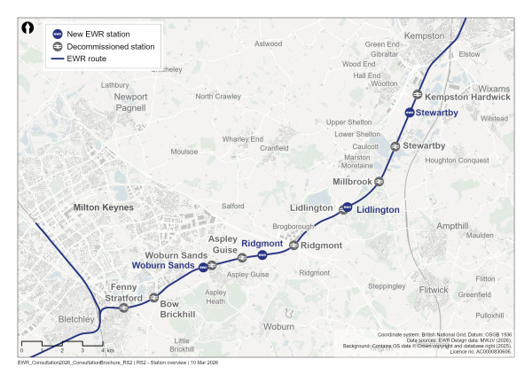
Figure 34: Map of new and decommissioned stations on the MVL
As part of our proposals to consolidate the existing stations on the MVL, the existing nine stations between Fenny Stratford and Kempston Hardwick would need to close (four would be rebuilt elsewhere). From west to east, these stations are Fenny Stratford, Bow Brickhill, Woburn Sands, Aspley Guise, Ridgmont, Lidlington, Millbrook, Stewartby and Kempston Hardwick.
The original station buildings are not part of the operational railway stations today and would be retained. Following consolidation, we’re proposing to fully decommission and demolish the remaining station infrastructure to reduce the potential for trespass and misuse of the stations, as well as the costs associated with repairing and maintaining much of the existing ageing infrastructure, including the timber construction of many of the existing platforms.
This approach would enable us to utilise the space occupied by existing station infrastructure in certain locations. For example, we’re looking to replace the northern platform at Lidlington with a new active travel connection between Station Road and the new Lidlington station.
We’re exploring how some of the existing station elements could be retained for community or legacy uses. For example, we would retain:
-
Fenny Stratford’s existing platform — this would avoid impacts on the adjoining listed station building, maintain its heritage setting and enable access to the building. Keeping the platform may enable the future use of this platform as part of a public right of way
-
Small sections of the southern platforms at Woburn Sands, Ridgmont and Millbrook. This would avoid impacts on the adjoining listed station buildings, maintain their heritage setting and enable access to the listed building at Woburn Sands
Approach to construction
Where temporary closures or diversions of public rights of way are needed as part of our works to decommission stations, we would provide a replacement route before the closure takes place.
The decommissioning of the existing stations would be supported by a number of small satellite construction compounds, generally positioned next to the stations themselves and within the existing railway boundary. As the decommissioning works are relatively limited in scale, they are expected to generate only minimal construction traffic.
Because the stations sit close to the operational railway, much of the decommissioning work would need to take place when trains are not operating, for example during night‑time or weekend closures or during a planned blockade of the railway.
Acceleration works
Some works on the MVL are being carried out early to prepare the route for future development phases. This includes works that Network Rail has already obtained planning permission for in a Transport and Works Act order (TWAO) made by the Secretary of State in 2020. The early works also include development that Network Rail is permitted to carry out as part of its general maintenance and improvement of the railway network. Network Rail will provide these works on EWR Co’s behalf, and they’re planned to be complete by 2030. The early works are referred to in this chapter as the ‘acceleration works’ and include:
-
The closure of seven level crossings on the MVL including associated replacement crossings and diversions. These replacements are:
-
Woodleys Farm — Network Rail is working with local stakeholders to close this level crossing, and integrate this closure with nearby housing developments and the delivery of a new road bridge proposed by Milton Keynes City Council to be built by 2030
-
Berry Lane, Long Leys, and Matey Boys — New access tracks would be provided between Salford Road and Bedford Road
-
Pilling Farm south — The footpath would be diverted to Station Road • Marston Road — A new road bridge would be provided at the level crossing location
-
Woburn Road — A new stepped footbridge would be provided
-
The replacement of the southern railway bridge at Saxon Street due to the poor condition of the current bridge. The new railway bridge would be wide enough to accommodate the two tracks required for EWR services
-
Environmental mitigation for the proposed works:
-
New planting next to Woodleys Farm Crossing
-
New planting near to Bedford Road
-
New planting next to Manor Road
-
Flood storage mitigation next to Lidlington village
-
Renewing existing infrastructure and other enabling works within the railway corridor. This includes replacement of existing track and track bed, and preparing for further site works such temporary surfacing and removal of vegetation
Our latest proposals
To describe our latest proposals, we’ve split this route section into five areas:
-
Fenny Stratford
-
Bow Brickhill and Woburn Sands
-
Aspley Guise and Ridgmont
-
Lidlington and Millbrook
-
Stewartby and Kempston Hardwick
Fenny Stratford
Fenny Stratford station decommissioning
Fenny Stratford station would close as part of our proposals. We would retain elements of the existing platform to avoid impacts on the adjoining Grade II listed building and maintain access to it. Working with the local authority, we would also seek to establish if we could retain the platform as a public right of way connecting Watling Street and Simpson Road.
Recognising the importance of connecting the existing users of Fenny Stratford station to EWR and other passenger services, we’ve been exploring how to best make Bletchley station, which is 1.3km (0.8 miles) to the south‑west, more accessible with a new eastern entrance that would be jointly provided with Milton Keynes City Council and central government partners. For further details, see the Bletchley station section in the Oxford to Bletchley route section chapter (Chapter 12).
We’re also working with Milton Keynes City Council and local bus operators to explore ways to improve bus connectivity between Fenny Stratford and Bletchley stations.
Level crossings
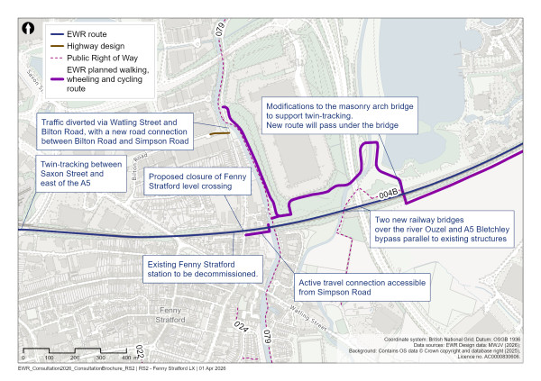
Figure 35: Map of proposed works in the Fenny Stratford area
Fenny Stratford (Simpson Road)
At our previous consultation, we proposed to retain Fenny Stratford level crossing on Simpson Road.
Our latest assessments show that, as a result of the higher train frequencies and train movements through Bletchley station, trains would at times need to stop before the station and would overlap the level crossing. This means that the level crossing barriers would be down for much longer durations in this location.
As a result of this, we anticipate traffic queues at the level crossing would be significantly longer at peak times, likely resulting in road traffic disruption to the roundabout to the south and the wider road network. Consequently, we believe it would be necessary for this level crossing to be closed.
We propose to divert traffic via Watling Street and Bilton Road, and extend Bilton Road through the industrial unit car parks to connect to it to Simpson Road. This new traffic route would avoid the need for HGVs to use Staple Hall Road during construction of the project.
We looked at different options for people walking, wheeling or cycling. This included considering a footbridge at, or close to, the existing level crossing. However, a footbridge in this location would not be possible without significant impacts on local businesses and residential properties.
We therefore propose a new active travel connection to the east, under the western end of the existing viaduct over the Grand Union Canal. This would be accessible from Simpson Road south of the railway via a new footpath and Lock View Lane. While this new route alongside the canal would be a longer diversion than the footbridge we considered, it would have lesser impacts on local properties while maintaining connectivity.
Fenny Stratford twin-tracking
As presented at our previous consultation, we’re proposing to install an additional track within the section of railway through Fenny Stratford between Saxon Street and the east of the A5 highway to accommodate additional EWR train services. This would restore double track to this location as it was when the route was originally constructed. The track widening works would require the construction of earthworks and retaining walls on both sides of the railway. Drainage tanks and ponds would be incorporated along this section of the railway.
Two new railway bridges would be built to carry the additional track over the River Ouzel and the A5 Bletchley by‑pass, adjacent to the existing railway bridges at these locations. Since our previous consultation, we’ve refined our bridge designs to minimise their impact on the floodplain. In addition, the masonry arch bridge to the east of the A5 would be modified to support railway twin‑tracking. We wouldn’t need to reconstruct the railway bridges at the Grand Union Canal or at Watling Street.
The southern railway bridge at Saxon Street would be replaced as part of the acceleration works. The new railway bridge would be wide enough to accommodate the two tracks required for EWR services.
To mitigate the impact of our twin‑tracking proposals on the environment, woodland and grassland planting would be provided on both sides of the railway between the Grand Union Canal and the A5. This area is prone to flooding so we would provide a drainage pond and flood compensation areas to reduce flood risk. Since our previous design, we’ve reduced the area of land required for flood compensation.
Caldecotte Lake is an important recreational space for the local community. Woodland planting would be provided in this area to mitigate the impact of twin‑ tracking. Grassland habitat affected within Caldecotte Lake would be reinstated where possible. We would also create a drainage channel on the north side of the railway to reduce flood risk.
To reduce railway noise impacts from the twin‑tracking proposals, noise mitigation measures, likely in the form of noise barriers, would be provided in the Fenny Stratford area between Simpson Road and the Grand Union Canal on the north side of the railway, and from the Sidings (residential properties) to a short distance east of the Grand Union Canal on the south side.
Approach to construction
The works required to provide the new twin‑track railway through the Fenny Stratford area would be supported by several construction compounds.
The embankment modification works on either side of the existing Saxon Way (A4034) would be serviced by a main construction compound located to the south of the railway, accessed from Tavistock Street. Construction traffic would reach this compound from the A5 via North Street, Princes Way, Saxon Street, and Bletcham Way.
In addition, a secondary satellite compound would be established to the north of the railway, situated within part of the supermarket car park on Watling Street and using a similar construction traffic route to the A5.
Further small satellite compounds positioned along the railway to the east would also be deployed to support delivery of the rail systems elements, including track and operational equipment. These would complement the compounds identified to facilitate construction of the new railway bridges at the River Ouzel and the A5.
The new railway bridges over the River Ouzel and the A5 would be constructed concurrently and supported by shared construction compounds. Due to the constrained locations of the proposed bridge structures and associated access requirements, multiple main construction compounds have been identified to facilitate the works and to provide suitable access for plant, equipment, and materials.
A main construction compound would be established in the open area situated between the distribution centre and the existing railway corridor, to the west of the A5. Access to this compound would be provided via a newly constructed access road from Simpson Road. Construction traffic is expected to be routed to the A5 via Bilton Road, Watling Street, and Bletcham Way.
A second main construction compound would be located to the south‑west of the railway, with access from the A5 via Watling Street and Belvedere Lane.
A third main construction compound would be positioned to the south‑east of the A5. Access to this compound would also be from the A5, either via the railway corridor from Brickhill Road or through the adjacent new development.
While we would seek to maximise construction activity during standard working hours, the proximity of the works to the operational railway would necessitate some major construction activities during night‑time or weekend railway possessions. A closure of the railway for an extended period would be required to enable the completion of the bridge structures and commissioning of the associated track works
Bow Brickhill and Woburn Sands
New Woburn Sands station
As confirmed in our You Said, We Did Autumn Update, we’re proposing to consolidate the existing Bow Brickhill and Woburn Sands stations into a new Woburn Sands station located between the two existing stations, west of Woburn Sands.
The location of the proposed station is shown in Figure 36. This site has been selected in order to:
-
Enable the construction of a significantly larger station with passenger carparking, bus and drop off and pick up facilities without needing to acquire land occupied by local properties and businesses
-
Make the station highly accessible from Woburn Sands, future local developments such as the SEMK development and the road network both north and south of the railway
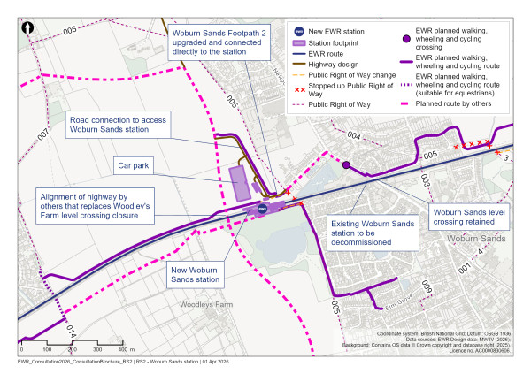
Figure 36: Map of the new Woburn Sands station
The station would have two platforms, a new station building north of the railway with passenger facilities, and a footbridge over the railway with lift access.
To support access to the station, we’re also proposing to:
-
Provide passenger car parking, an active travel hub with bicycle storage and other amenities, and drop off and pick up, taxi and bus facilities at the station
-
Strengthen the active travel connection between Woburn Sands and the new station via Elliot Avenue by providing a new pedestrian crossing on Newport Road, which would help those living and working in northern Woburn Sands cross Newport Road more safely
-
Upgrade Woburn Sands Footpath 2 (Fisherman’s Path) and connect it directly into the station, which would allow residents of Woburn Sands who live south of the railway to reach the station via Drayhorse Crescent and Elm Grove
-
Provide a new active travel route between Pony level crossing and the new station along the north side of the railway. This would connect with existing active travel routes through Old Farm Park and Browns Wood, helping to make the station more accessible for communities and businesses to the west
-
Integrate the station with the new active travel routes and emerging highways access points being constructed as part of the new SEMK development, including connections to the new development, Bow Brickhill and Brickhill Road
The new car parking provided at this station would help railway passengers using a vehicle for the first leg of their journey, particularly given the limited car parking at the existing stations at Bow Brickhill and Woburn Sands. We’re also working with Milton Keynes City Council and local bus operators to explore how the new station could be better connected with existing and new bus services in these areas.
We’re continuing to explore opportunities with local property developers to further integrate the station with surrounding developments, which could result in some reconfiguration of station facilities.
As part of our environmental mitigation proposals, we would provide flood compensation areas at the new Woburn Sands station to reduce flood risk. In addition, a 30‑metre strip of woodland would be planted on the eastern edge of the station to screen the new Redrow property development from the railway. On the south side of the railway, the majority of the existing priority habitat woodland north of the fishing lake would be protected.
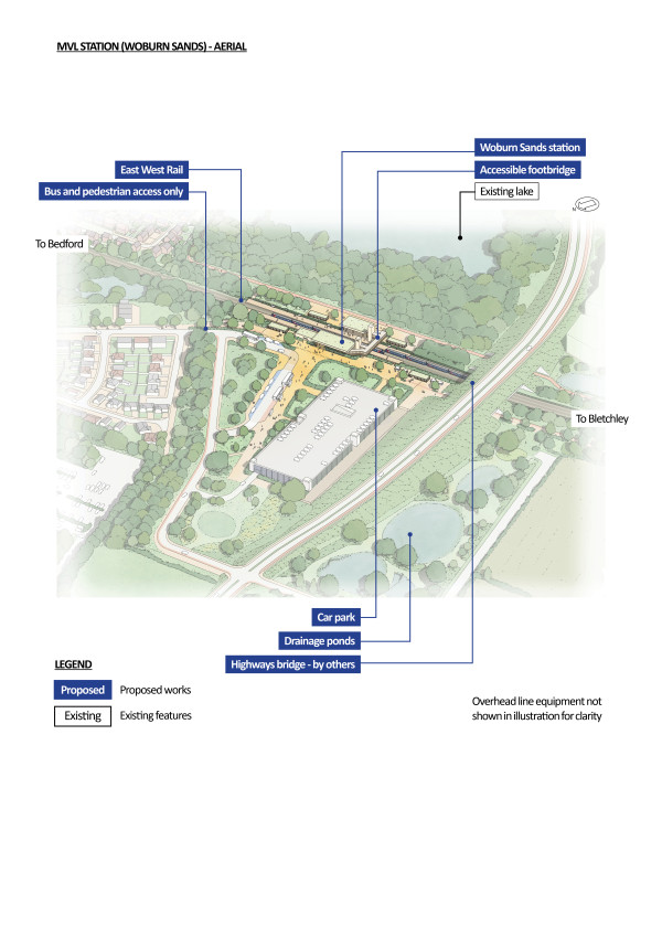
Figure 37: An indicative aerial illustration of the new Woburn Sands station
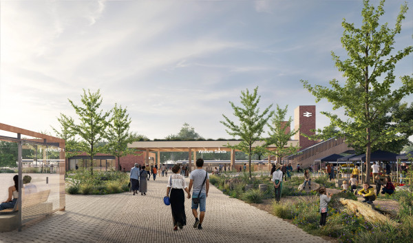
Figure 38: An indicative illustration of the new Woburn Sands station
Approach to construction
The construction of the new Woburn Sands station would be supported by a construction compound situated to the north of the railway and accessed from the A421 dual carriageway by Newport Road (A5130).
This compound would be located adjacent to the new station site to minimise impacts on local residents while enabling efficient construction and use of most appropriate construction traffic routes.
Level crossings
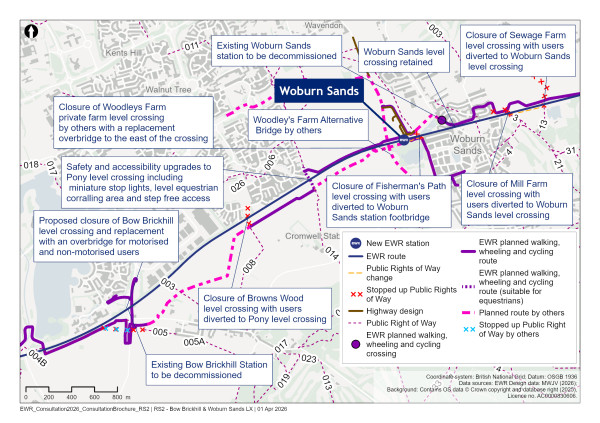
Figure 39: Map of Woburn Sands level crossings
Bow Brickhill (V10 Brickhill Street)
At our previous consultation, we explained that we were still carrying out traffic modelling work to determine whether Bow Brickhill level crossing would need to be closed. In November 2025, we confirmed in our You Said, We Did Autumn Update that, if closure was required, it would be replaced with a new road bridge and not a diversion via the A5 highway.
Our modelling shows that, if the level crossing were to remain open, the increased barrier downtime would have an unacceptable impact on road vehicle journey times and cause traffic congestion at key local junctions. We therefore propose to close this level crossing and provide a new road bridge connecting Brickhill Street and Brickhill Road on either side of the railway.
Due to surrounding constraints, the proposed road bridge would be slightly east of the existing road alignment. A new road connection is proposed to Caldecotte Lake Drive, at a higher level than it currently connects, with new embankments around it. We propose to maintain much of the existing vegetation between residential properties and Caldecotte Lake Drive/Brickhill Street to reduce the visual impact of the bridge.
A road noise barrier would be provided for existing residential properties in Caldecotte due to the raised road height at Caldecotte Lake Drive and Brickhill Street.
A new roundabout would be proposed at the Sherbourne Drive junction, and anew lane on Brickhill Street. This would provide access to the Red Bull Technology Campus, replacing the current road access that would not be useable with the new bridge.
To the south of the railway, the bridge would connect into Brickhill Road with new embankments and retaining walls. The road would also connect to Station Road aligning with the proposed road connections as part of the SEMK development. This connection will need to be raised to meet compliant gradients for the bridge approach.
At our previous consultation, some respondents expressed concern about the negative impacts of the new bridge. We’re continuing to develop our design for the road bridge to reduce impacts on neighbouring properties and businesses as much as is practicable. However, we’ve concluded that it would not be possible to provide this bridge without the acquisition of properties on Station Road. We’ve informed those impacted and offered support through our Land and Property team. We’re also carrying out further work to reduce land take as much as possible.
Approach to construction
Construction works at Bow Brickhill would comprise a series of highway realignments, including Station Road, Brickhill Street and Caldecotte Lake Drive, to provide access to a new road bridge to replace the existing level crossing.
To facilitate these activities, a main construction compound would be established on both sides of the railway corridor.
To the south, a construction compound would be located adjacent to Station Road, with construction traffic routed to the A5 via Brickhill Road.
To the north, a second construction compound would be situated within the land parcel between the operational railway and Caldecotte Lake Drive. Access to this compound would be provided from the A5 via Bletcham Way and Brickhill Street.
Browns Wood
As presented at our previous consultation, we’re proposing to close Browns Wood level crossing and divert users to Pony level crossing. A new public footpath would be provided on the south side of the railway from Browns Wood to Pony level crossing to maintain connectivity for existing users of Browns Wood level crossing. On the north side, users would reach Pony level crossing via Holt Crescent and Boyce Crescent.
Pony
As presented at our previous consultation, we’re proposing to keep Pony level crossing open and upgrade it to include miniature stop lights. These indicate to users whether it is safe to cross. The steps would be replaced with ramps to improve overall safety and accessibility for users.
Since our previous consultation, we’ve refined our designs of the ramps for the Pony level crossing to minimise the impact on residential properties and reduce hedgerow loss. At this level crossing we are looking to keep the existing hedgerow on the north side by routing the ramps to the east of this existing hedgerow. we will also look to plant an area of woodland to provide visual screening. on the south side we are looking to integrate with the SEMK development.
Woodleys Farm
As part of the acceleration works, Woodleys Farm private farm level crossing would be closed. Network Rail is working with local stakeholders to integrate the closure of this level crossing with development of nearby housing and the provision of a new road bridge proposed by Milton Keynes City Council to be built by 2030.
Fisherman’s Path
As presented at our previous consultation, we’re proposing to close Fisherman’s Path footpath level crossing, which is located to the west of Woburn Sands. Pedestrians and dismounted cyclists would still be able to cross the railway in this location using the footbridge proposed as part of the new Woburn Sands station, which would also be accessible to people without train tickets.
Woburn Sands (Newport Road/Station Road)
At our previous consultation, we expressed a preference to retain the Woburn Sands level crossing as a CCTV level crossing. As a result of higher frequency of train services, we anticipate that barrier downtimes at this crossing would increase to 26‑ 28 minutes within the hour.
Initial assessments suggest it would be possible to keep this level crossing open because the new road bridge west of Woburn Sands would provide a more convenient route for most road users to connect to Newport Road and Bow Brickhill Road through the SEMK development. Our current proposal therefore remains to keep the crossing open.
Mill Farm
As presented at our previous consultation, we’re proposing to close Mill Farm footpath level crossing and divert users via existing routes to Woburn Sands level crossing. North of the railway, users would be diverted through Vandyke Close and Cranfield Road to Newport Road. South of the railway, users would be diverted through Mill Lane and Station Road.
We would provide tree planting and habitat creation near this level crossing.
Sewage Farm
As presented at our previous consultation, we’re proposing to close Sewage Farm footpath level crossing and divert users to Woburn Sands level crossing using existing routes and a new section of footpath.
Aspley Guise and Ridgmont
New Ridgmont station
As confirmed in our You Said, We Did Autumn Update, we’re proposing to consolidate the existing Aspley Guise and Ridgmont stations into a new Ridgmont station located west of the M1 motorway.
The location of this station is shown in Figure 40. We selected this location because of its potential to unlock development north of Aspley Guise, its central position between existing communities and to enable us to provide new station amenities, including passenger car parking, bus and drop off and pick up facilities, without impacting neighbouring landowners.
The construction of a new station at Ridgmont is intrinsically linked to wider proposals for the development of future housing in this location. New highways infrastructure would be required to support that development, and to provide access to the new Ridgmont station. The new highways infrastructure would therefore be subject to part‑funding by that development. National Highways is considering long‑term options to carry out improvements to nearby junction 13 of the M1. Further improvements may be necessary for the new Ridgmont station road infrastructure to connect to Bedford Road, without exacerbating existing congestion at that junction.
We’re working with Central Bedfordshire Council and National Highways to explore these issues. These factors could mean Ridgmont station would need to be built and opened to passenger services later than other stations on the Marston Vale Line. If this transpires, we would explore how to provide suitable connectivity between the existing Ridgmont station to the new Woburn Sands station until the new Ridgmont station opens.

Figure 40: Map of the new Ridgmont station
The new station would have two platforms, a modern station building north of the railway with associated facilities, and a footbridge over the railway with lift access.
To support access to the station, we’re proposing to:
-
Provide passenger car parking, an active travel hub with cycle storage and other amenities, and drop off and pick up, taxi and bus facilities at the station
-
Design a road connection with active travel infrastructure to Bedford Road, to the east and on the northern side of the railway. We are also still considering an alternative connection to the A421 dual carriageway north‑ west of the station’s location if a connection to Bedford Road is not viable. The draft order limit boundary covers both solutions and will ultimately reduce in size.
-
Provide a new active travel route north of the railway and under the M1 between the station and the Ridgmont station Heritage Centre and Tea Rooms, Marston Gate Logistics Park and Brogborough
-
Upgrade access tracks to provide an active travel route between Salford Road and the new station
-
Create a new active travel route connecting Aspley Guise centre to the station via Berry Lane south of the railway
-
Upgrade Husborne Crawley Footpath 6 and connections towards Church End using the existing footpath and a new section of footpath
We’re continuing to collaborate with key stakeholders on the design and access strategy for this station in order to:
-
Not preclude Bedford and Milton Keynes Waterway Trust’s aspirations to create a waterway between Bedford and Milton Keynes running parallel to the railway in this area
-
Confirm our car parking strategy in this location, how it could encourage people to make journeys by train rather than by car, and the potential traffic implications of doing so
-
Confirm how the station can be integrated effectively with the local and strategic highway network
As part of our environmental mitigation proposals, an area of woodland would be planted directly south of the new Ridgmont station. This woodland would help screen the car parking and preserve the heritage setting of churches and several Grade II listed buildings located on higher ground further south in Church End. Additionally, grassland would be provided in and around the station to enhance the natural environment.
Vegetation and grassland would be planted north of the existing railway to fit in with the existing environment. From north of Ridgmont to Lidlington, through Broughton, the majority of woodland would be retained and new woodland, grassland, and vegetation would be provided along this stretch of the route to further enhance the natural landscape.
We’re still assessing the flood risk in the area and we may need to construct drainage ponds and flood compensation areas to mitigate the risk of flooding from the new station infrastructure. New grassland would be planted around these features to integrate them into the local environment.
Approach to construction
The construction of the new Ridgmont station would be supported by a construction compouns located adjacent to junction 13 of the M1, with access provided via Bedford Road. This compound would be positioned to minimise impacts on local residents while enabling efficient construction and appropriate construction traffic routes.
Level crossings
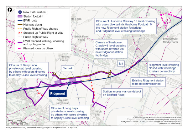
Figure 41: Map showing our proposals for Aspley Guise and Ridgmont level crossings
Aspley Guise (Salford Road)
As presented at our previous consultation, we’re proposing to keep Aspley Guise (Salford Road) road level crossing open as a CCTV crossing. With more frequent train services, we would anticipate that barrier downtimes at this crossing would increase to 30‑32 minutes in the hour. However, the expected spacing of train services means there would be sufficient periods when barriers are raised to avoid unacceptable wait times for road vehicles.
Old Manor Farm
As presented at our previous consultation, we’re proposing to close Old Manor Farm footpath level crossing to the east of Aspley Guise. Users would be diverted to the Aspley Guise (Salford Road) crossing along a new access track and footpath that would be built on the north side of the railway.
Berry Lane
As part of the acceleration works, Berry Lane private road level crossing would be closed.
Long Leys
As part of the acceleration works, Long Leys level private farm level crossing would be closed.
Husborne Crawley 6
As presented at our previous consultation, we’re proposing to close Husborne Crawley 6 footpath level crossing.
Following the confirmation of the location of Ridgmont station, users would be diverted to the new Ridgmont station footbridge. The footbridge would sit outside of the ticket barrier system and would therefore be accessible to people without train tickets.
Matey Boys
As part of the acceleration works, Matey Boys private farm level crossing would be closed.
Husborne Crawley 10
As presented at our previous consultation, we’re proposing to close Husborne Crawley 10 Footpath level crossing.
However, instead of diverting to Ridgmont level crossing as previously proposed, users would be diverted users to the new Ridgmont station footbridge. The footbridge would sit outside of the ticket barrier system and therefore be accessible to people without train tickets.
New footpaths would be provided to connect to Husborne Crawley Footpath 6 in the south. In the north, the diversion would follow the new active travel route adjacent to the railway.
Ridgmont (Station Road)
At our previous consultation, we proposed to keep Ridgmont (Station Road) level crossing open.
We now propose to close Ridgmont (Station Road) level crossing because it wouldn’t be possible to run overhead electrification over the level crossing at a safe height given how low these wires would need to be to pass under the adjacent A507 bridge.
To mitigate the impact of this closure on traffic, existing roads would be used to divert traffic via the A507 which runs parallel to Station Road.
To support pedestrians crossing the railway in this location, we’ve considered options for footbridges at either the level crossing or to the west by the A507 and connecting back to Station Road.
While a footbridge over the existing level crossing may have some advantages, we don’t believe we could provide it without disrupting local businesses and visually impacting the Grade II listed former station building, which currently houses the Ridgmont station Heritage Centre and Tea Rooms. For these reasons, we’re proposing a new footbridge in close proximity to the A507, which would integrate better into the landscape.
The closure of the level crossing would require staff and visitors to the Ridgmont Heritage Centre and Tea Rooms to use this footbridge to reach their existing car park north of the railway. To avoid this, we propose to relocate the car parking south of the railway.
Lidlington and Millbrook
New Lidlington station
As confirmed in our You Said, We Did Autumn Update, we’re proposing to consolidate the existing Lidlington and Millbrook stations into a new Lidlington station located 200 metres east of Lidlington village centre to support new housing and development.
The selected location, shown in Figure 42, allows for a larger station with passenger facilities without affecting local properties, while retaining good connectivity to Lidlington village centre. It also supports sustainable travel to and from the Marston Valley development north of Lidlington, which is allocated for development in the adopted Central Bedfordshire Local Plan 2015 to 2035.
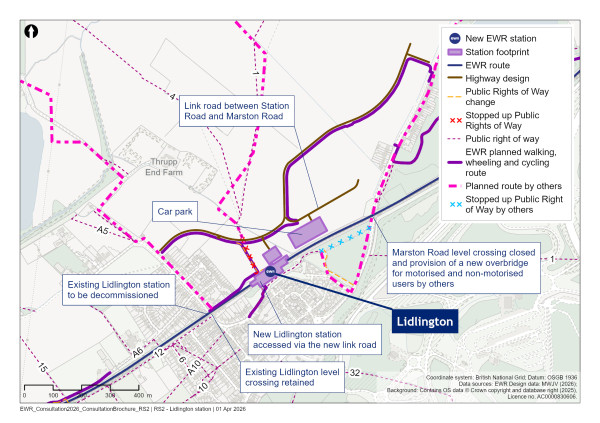
Figure 42: Map of the new Lidlington station
The station would have two platforms, a new station building north of the railway with associated facilities, and a footbridge over the railway with lift access.
To support access to the station, we’re also proposing to:
-
Provide passenger car parking, an active travel hub with cycle storage and other amenities, and drop off and pick up, taxi and bus facilities at the station
-
Create a new link road between Station Road and Marston Road through the Marston Valley development. This is intended to make the station accessible from the road network without increasing traffic through Lidlington village and the level crossing at its centre. The road would also include active travel provision for walkers, wheelers and cyclists.
-
Create a new active travel route north of the railway between Station Road and the station. This would use space currently used for Lidlington station’s northern platform, and would help individuals living close to the existing station to access the new station
-
Make the station accessible from the south of the railway by connecting into the existing footpath running between Lombard Street and the new footpath being provided to Marston Road as part of the acceleration works
-
Link the new station to existing active travel routes between Marston Road North, the existing Millbrook station and the Forest of Marston Vale. We’re seeking to reduce impacts on the Grade II listed Millbrook station building within our design
We’re also continuing to work with the promoters of the Marston Valley development to integrate our station proposals and active travel routes with their own proposals.
As part of our environmental mitigation proposals, woodland would be planted to the west of the proposed Lidlington station to provide screening and limit visual impacts to residential properties along Station Road and Church Street. Additionally, a small parcel of woodland would be provided south of the station to benefit communities south of the railway. A flood compensation area would be relocated, south of the Thrupp End scheduled monument site.
Approach to construction
The construction of the new Lidlington station, together with the associated highway works, would be supported by a construction compound positioned adjacent to Marston Road. Construction traffic would utilise Marston Road/Station Road to the north towards the A421 dual carriageway, as well as Marston Road/Bury Ware to the south towards the A507. This compound would be located adjacent to the permanent works to minimise impacts on local residents while enabling efficient construction and use of appropriate construction traffic routes.
Level crossings
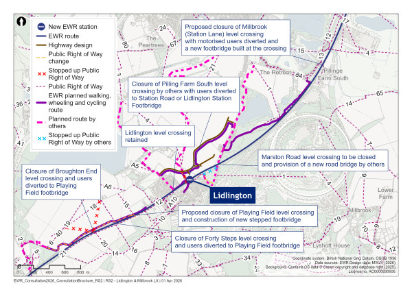
Figure 43: Map showing our proposals for level crossings in the Lidlington area
Broughton End
As set out at our previous consultation, we’re proposing to close Broughton End footpath level crossing and divert users to Playing Field. As explained in more detail below, this would require users to divert to the new stepped footbridge at Playing Field.
Forty Steps
Consistent with plans presented at our previous consultation, we’re proposing to close Forty Steps footpath level crossing. We propose to divert users to the new stepped footbridge at Playing Field.
Playing Field
In our previous consultation we proposed to keep Playing Field footpath level crossing open by installing a miniature stop light system to mitigate safety risks created by the increase in service frequencies.
Now that we’re considering operating up to five passenger trains per hour in each direction, we’ve concluded that the level crossing must close because we cannot ensure level crossing users would have sufficient visibility of oncoming trains to use the level crossing safely.
We’ve looked at different options for pedestrians including a stepped footbridge at, or close to, the existing level crossing, or the construction of a new underpass near to Forty Steps.
Given the current usage of the crossing and the rural nature of the connecting footpaths, we’re proposing the construction of a stepped footbridge at the crossing.
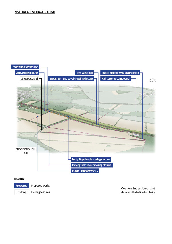
Figure 44: An indicative aerial illustration of how we propose to use active travel routes to mitigate level crossing closures
Lidlington (Station Road)
Our proposals for Lidlington (Station Road) road level crossing have not changed since our previous consultation.
We’re proposing to keep Lidlington (Station Road) road level crossing open as a CCTV crossing to maintain connectivity within the village.
As we look to provide more frequent services, we would anticipate that barrier downtimes at this crossing would increase to 26‑28 minutes in the hour. However, the expected spacing of train services means there would be sufficient periods when barriers are raised to avoid unacceptable waiting times for vehicles.
We would provide a diversion via the new link road between Station Road and Marston Road towards the new road bridge proposed at Marston Road as part of the acceleration works. Our modelling indicates that traffic from the south would naturally divert via this route, which means drivers could avoid needing to wait at the level crossing.
Additionally, the new Lidlington station would be roughly 200 metres from the crossing, which means people without train tickets could also use the new station footbridge as an alternative means of crossing the railway line in this location.
Pilling Farm South
As part of the acceleration works, Pilling Farm South level crossing would be closed. With the relocation of Lidlington station, the new station footbridge, located near the closed crossing, could be used as an alternative diversion route.
Marston (Marston Road)
As part of the acceleration works, Marston Road level crossing would be closed for safety reasons, and a new road bridge provided. This bridge, which would be built by 2030, would provide connectivity for traffic during the railway’s construction and operational phases.
Millbrook (Station Lane)
At our previous consultation, we proposed to keep Millbrook (Station Lane) level crossing open.
We now propose to close Millbrook (Station Lane) level crossing because it wouldn’t be possible to run overhead electrification over the level crossing at a safe height given how low these wires would need to be under the existing power lines.
We previously explored if we could provide a road bridge in this location. However, we’ve concluded that this wouldn’t be possible without significantly impacting neighbouring properties including the Grade II listed station house and Millbrook Proving Ground. A road bridge would also require us to divert the existing power lines closer to existing habitats within the Forest of Marston Vale, potentially impacting sensitive nesting areas. Our decision to electrify this route section would increase the scale of a bridge required in this location to achieve the necessary clearances, so worsening these impacts. In light of this, we’re proposing to divert users to Marston Road via Bury Ware, the A507 and Sandhill Close.
To maintain connectivity for walkers, wheelers and cyclists across the level crossing, three different footbridge locations were considered: at the same location as the level crossing, to the north of it and to the south of it. The new footbridge is proposed to be 250 metres north of the existing crossing which would connect back to Station Lane via existing footpaths. This location for the footbridge would avoid having to relocate overhead power lines into existing habitats within the Forest of Marston Vale, potentially impacting sensitive nesting areas.
Stewartby and Kempston Hardwick
New Stewartby station
As confirmed in our You Said, We Did Autumn Update, we’re proposing to consolidate the existing Stewartby and Kempston Hardwick stations into a new Stewartby station located north of Broadmead Road. We also committed to continuing to work with Universal and other key stakeholders to design a station which could support both the local area and the Universal Entertainment Resort Complex.
Now that the Universal Entertainment Resort Complex has received planning permission, we’re planning to locate the station just north of Universal’s proposed access road between the A421 dual carriageway and their resort. The proposed location of the station is shown in Figure 45. This is a little further north than we were previously proposing, and we believe this is the optimum location to make the station accessible from the resort, minimise impacts on the Universal masterplan and serve local communities.
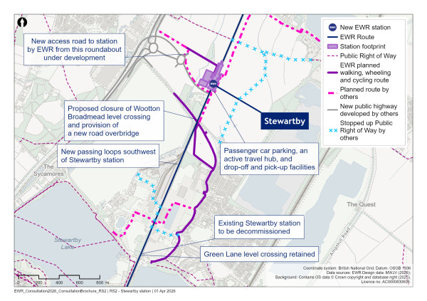
Figure 45: Map of the new Stewartby station
Given the proximity to the Universal Entertainment Resort Complex, the design of this station may differ from others along the route. In particular, we’re considering:
-
A platform and track layout that would allow for flexibility in rail services over the long term. We’re proposing to provide up to four platforms, some of which would be designed to allow for the stopping and turning around of longer trains
-
Enhanced pedestrian infrastructure, such as entrances, bridges, stairwells, lifts, gate lines and platform widths, to support more intense usage and more visitors travelling with children and luggage
-
The need for additional staffing, customer service and commercial facilities to provide a high‑quality passenger experience
The station would also be equipped with passenger car parking, an active travel hub with cycle storage and other amenities, and drop off and pick up facilities.
We plan to support access to this station by sustainable means, particularly given the greater distance between the station and the communities at Stewartby, Kempston Hardwick and Kimberly Sixth Form College. For this reason:
-
We’re working with Universal on the design and provision of the active travel routes outlined within their planning submission which would provide connections towards Wooton, Stewartby and Kempston Hardwick
-
We’re working with others, including Bedford Borough Council and local stakeholders, on active travel connections beyond the Universal Entertainment Resort Complex site which would support access to Stewartby and Kimberly College
-
We’re working with Universal, Bedford Borough Council and local bus operators to explore ways to improve bus connectivity to this destination
To reduce railway noise impacts on local residents, noise mitigation measures would be provided at Stewartby on both sides of the railway between Green Lane and just south of Broadmead Road.
Our environmental mitigation proposals for the station are at an early stage, and we’re engaging with Universal to integrate our plans with their proposals.
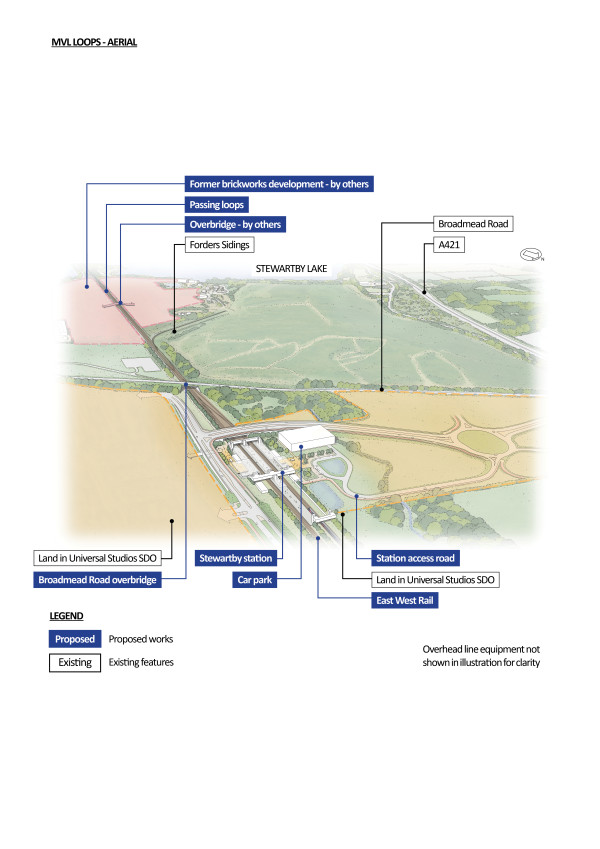
Figure 46: An indicative aerial illustration of the new Stewartby station including loops south of the station. Detail of proposals within the Entertainment Resort Complex Special Development Order boundary is subject to ongoing discussions.
Approach to construction
The construction of the new Stewartby station would involve the proposed realignment of Broadmead Road and construction of the associated new bridge structure. These works would be supported by main and satellite construction compounds located to the south and north of the railway. The compounds would also support the civil engineering and rail systems activities (track and operational equipment) required for the new passing loop between Green Lane and Broadmead Road.
Construction traffic for these works would primarily be routed northwards to the A421 dual carriageway via Bedford Road. Additional routes may include Broadmead Road and Green Lane to rejoin Barford Road/A421 dual carriageway.
Although we would undertake most construction activities during standard working hours, the proximity of the new station works to the operational railway means that a substantial proportion of construction activities would need to take place during night‑time or weekend track possessions. A closure of the railway for an extended period is anticipated to facilitate completion and commissioning of the new passing loop track.
Level crossings
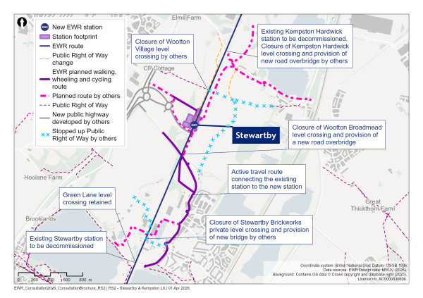
Figure 47: Map showing our proposals for level crossings around the new Stewartby station
Green Lane
At our previous consultation, we proposed to keep Green Lane level crossing open.
We appreciate the connectivity this level crossing currently provides, and we propose to keep the level crossing open if possible. However, now that we’re considering operating up to five passenger trains per hour in each direction, we’re anticipating the barrier downtimes at this crossing would increase to 32‑34 minutes in the hour. This may result in traffic impacts, delays to users and safety issues due to potential misuse. We’re continuing to undertake modelling and assessments to understand these impacts and confirm our proposal.
Stewartby Brickworks
At our previous consultation, we proposed to close Stewartby Brickworks occupation (private land) level crossing.
We anticipate that this level crossing would be closed and replaced with a road bridge that could also be used by people walking, wheeling or cycling who use this route, as part of the Stewartby Brickworks development prior to the opening of the railway.
Wootton Broadmead
In our previous consultation, we proposed to keep Wootton Broadmead (Broadmead Road) level crossing open.
We’re now proposing to close this level crossing. The increase in the number of rail tracks needed to run through this section to four tracks means the safety and operational risk would be too high to operate a level crossing at this location.
To maintain existing connectivity, we’re proposing to provide a new road bridge in the same location as the existing level crossing. This bridge is being designed to reduce impacts on the sensitive environmental features of Elstow Brook and priority habitat woodland to the west of the crossing.
Wootton Village
In our previous consultation, we proposed to close Wootton Village footpath level crossing.
With Universal Entertainment Resort Complex proposals moving forward, we anticipate that the crossing would be closed and diverted as part of their development plans.
Kempston Hardwick (Manor Road)
At our previous consultation, we explained that Network Rail had plans to construct a new bridge at Manor Road, which meant the Kempston Hardwick level crossing could close.
With Universal Entertainment Resort Complex proposals moving forward, we anticipate that the crossing would close and be diverted as part of their development plans. Their proposals would provide a new road bridge south of the existing crossing, which would connect into Manor Road east of the railway. They would also provide a new footbridge at the crossing as part of their plans.
Woburn Road
As part of the acceleration works, Woburn Road level crossing would be closed.
Passing loops
We previously presented six alternative locations for passing loops. These included two options in the Ridgmont area and four in the Stewartby area.
With the increase in the number of train services and the usage of Stewartby station, we’ve now selected a location for two passing loops, one on each side of the existing railway, between Green Lane and the new Stewartby station. This would mean trains could adequately service and terminate at the new station. The loops would also allow faster trains to pass slower trains.
More crossovers between the tracks and extra signalling would be required to allow different services to access the new station. The passing loops would also help the continued use of Forders Sidings, so that freight could continue to access the sidings alongside the passenger services on the route.
We’re also exploring if the area of Stewartby would be a suitable location for stabling sidings, as an alternative to those being proposed at Jowett Sidings in the Bedford route section.
Level crossings summary table
The table below summarises our proposals for the level crossings on the MVL. Where our level crossings proposals haven’t changed since our previous consultation, where we’ve progressed with one of two previously presented options or where the proposals are part of the acceleration works explained earlier in this chapter, we’ve greyed out the relevant row of the table. We’ve left the background white for level crossing proposals that have changed since our previous consultation to draw particular attention to them.
Table 1: Summary of MVL level crossing proposals
|
Level crossing name |
Current type of crossing |
Proposal at 2024 consultation |
Latest proposal |
|
Fenny Stratford (Simpson Road)
|
Highway
|
Retain as a CCTV crossing. Crossing would need to be widened to accommodate the new railway twin-tracking in this area. |
Close and divert the highway via Watling Street and Bilton Road. Provide a new route for cyclists and pedestrians alongside the Grand Union Canal.
|
|
Bow Brickhill (V10 Brickhill Street) |
Highway |
Retain as a CCTV crossing or, if the crossing cannot be retained due to traffic impacts, close and replace with a new road bridge to the east of the crossing. |
Close and provide a road bridge at the crossing. |
|
Browns Wood |
Footpath |
Close and divert to Pony crossing. Diversion via new footpath south of the railway. |
No change. |
|
Pony |
Bridleway |
Retain and upgrade to miniature stop light crossing (MSL). |
No change. |
|
Woodleys Farm |
Occupation (private land) |
Close and extinguish crossing rights. Alternative routes for authorised users are available. The closure of this crossing was authorised by the Transport Works Act Order (TWAO) made in 2020. |
Close with closure integrated with new road bridge proposed by Milton Keynes City Council. |
|
Fisherman’s Path |
Footpath |
Close and divert users to Woburn Sands level crossing or new station. The closure of this crossing was authorised by the TWAO made in 2020. |
Close and divert via new Woburn Sands station.
|
|
Woburn Sands (Newport Road/Station Road) |
Highway |
Retain as a CCTV crossing. |
No change. |
|
Mill Farm |
Footpath |
Close and divert to Woburn Sands level crossing. Diversion via existing footpaths. |
No change.
|
|
Sewage Farm |
Footpath |
Close and divert footpath. A new section of footpath is proposed between Mill Farm and Sewage Farm crossings south of the railway to provide a circular walking route. |
No change. |
|
Aspley Guise (Salford Road) |
Highway |
Retain as a CCTV crossing. |
No change. |
|
Old Manor Farm |
Footpath |
Close and divert users to Aspley Guise level crossing. Diversion route via Berry Lane south of the railway and a proposed new access track north of the railway. |
No change.
|
|
Berry Lane |
Occupation (private land) |
Close and diversion via roads/access tracks. Diversion would be to Aspley Guise level crossing. Diversion route via existing roads south of the railway and a proposed new access track north of the railway. The closure of this crossing was authorised by the TWAO made in 2020. |
Is being closed and users diverted via access tracks as part of the acceleration works.
|
|
Long Leys |
Accommodation |
Close crossing and divert users to Aspley Guise level crossing. Diversion route via Berry Lane south of the railway and proposed new access tracks north of the railway. The closure of this crossing was authorised by the TWAO made in 2020. |
Is being closed and users diverted via access tracks as part of the acceleration works. |
|
Husborne Crawley 6 |
Accommodation |
Close and extinguish crossing rights. Alternative access available via Bedford Road. The closure of this crossing was authorised by the TWAO made in 2020.
|
Is being closed with users diverted via access tracks as part of the acceleration works. |
|
Matey Boys |
Accommodation |
Close and extinguish crossing rights. Alternative access available via Bedford Road. The closure of this crossing was authorised by the TWAO made in 2020. |
Is being closed with users diverted via access tracks as part of the acceleration works. |
|
Husborne Crawley 10 |
Footpath |
Close crossing and divert users to Ridgmont level crossing or station footbridge depending on which Ridgmont station option is chosen. Diversion route via public footway along Mill Road. The closure of this crossing was authorised by the TWAO made in 2020. |
Close and divert via Husborne Footpath 6 and new Ridgmont station footbridge. |
|
Ridgmont (Station Road) |
Highway |
Retain as a CCTV crossing if Ridgmont station is relocated (Option 1). Close crossing if Ridgmont station is located at existing station location (Option 2). Vehicles diverted via A507 and pedestrians to use new station footbridge. |
Close and divert traffic via the A507 and provide a new footbridge. |
|
Broughton End |
Footpath |
Close and divert users to Playing Field level crossing. Diversion via existing footpaths. |
No change. (Playing Field crossing now proposed to be a footbridge). |
|
Forty Steps |
Footpath |
Close and divert users to Playing Field level crossing. Diversion route via existing footpaths south of the railway and a new footpath north of the railway. |
No change. (Playing Field crossing now proposed to be a footbridge).
|
|
Playing Field |
Footpath |
Retain and upgrade to MSL crossing. |
Close and provide a stepped footbridge. |
|
Lidlington (Station Road) |
Highway |
Retain as a CCTV crossing. |
No change. |
|
Pilling Farm south |
Footpath |
Close and divert footpath. Diversion to Station Road or alternate diversion route via proposed Lidlington station footbridge. The closure of this crossing was authorised by the TWAO made in 2020. |
Is being closed and users diverted to Station Road as part of the acceleration works. |
|
Marston (Marston Road) |
Highway |
Assumed to be closed by Network Rail with new bridge to pass over the railway. If not closed, would be upgraded to full barrier crossing. The closure of this crossing was authorised by the TWAO made in 2020. |
Is being closed and new road bridge provided as part of the acceleration works.
|
|
Millbrook (Station Lane) |
Highway |
Retain as a CCTV crossing. |
Close and divert traffic via Bury Ware, the A507 and Sandhill Close, and provide footbridge north of the crossing. |
|
Green Lane |
Highway |
Retain as a CCTV crossing. |
No change. |
|
Stewartby Brickworks |
Occupation (private land) |
Close with no replacement. Footpath to be extinguished north and south of railway. |
Is being closed and a replacement bridge being provided by the developer of the Stewartby Brickworks site. |
|
Wootton Broadmead (Broadmead Road) |
Highway |
Retain as a CCTV crossing. |
Close and provide a road bridge at the crossing. |
|
Wootton Village |
Footpath |
Close and divert to Kempston Hardwick crossing. Diversion via new footpaths east and west of the railway. |
Is being closed and diverted by Universal Entertainment Resort complex |
|
Kempston Hardwick (Manor Road) |
Highway |
Assumed to be closed by Network Rail with new bridge to pass over the railway. If not closed, would be upgraded to full barrier crossing. The closure of this crossing was authorised by the TWAO made in 2020. |
Is being closed and replacement road bridge and footbridge being provided by Universal Entertainment Resort Complex. |
|
Woburn Road |
Footpath |
Assumed to be closed by Network Rail with new footbridge. If not closed, would be upgraded to MSL crossing. The closure of this crossing was authorised by the TWAO made in 2020. |
No change |
Share your feedback
As part of this consultation, we would like to hear your feedback on our revised proposals for the MVL. We’re particularly interested on your views on our proposals for:
-
Connectivity proposals for the new stations
-
The seven level crossings where our proposals have changed since our previous consultation
You can complete our online feedback form or find details of other ways to respond to our consultation in the How to respond to this consultation chapter of this brochure.
This is where the Fenny Stratford to Kempston route section ends. The railway would then transition to the Bedford route section.
14. Bedford
East West Rail is proposing investment in Bedford with plans that would provide a significant upgrade to the town’s transport network and public spaces. This includes a remodelled station at Bedford and a new, modern station at Bedford St Johns, improved parking facilities, and new opportunities for placemaking around the station areas.
The changes around Ashburnham Road would unlock better access to Bedford Hospital, provide stronger links to the town centre and improve existing connections to the east side of Bedford.
The remodelling of Bedford station will improve platform capacity allowing for better connections on all routes through the station.
East West Rail (EWR) would operate through Bedford on a 5.4km (3.4 mile) route section. This route starts at Ampthill Road in Kempston and ends at Clapham Road, south‑east of the village of Clapham. Our work on this route would include installing new tracks, providing overhead line electrification, realigning the track curve south of Bedford St Johns station, relocating Bedford St Johns station, and remodelling Bedford station. This chapter presents our updated proposals for the Bedford route section.
As part of this consultation, we are seeking your views in particular on our proposals for:
-
The realigned track curve south of Bedford St Johns station
-
The revised Bedford St Johns station design and multi‑storey car park
-
The remodelled Bedford station, including a new civic plaza, western entrance, a new platform for fast trains to London, and a new location for the multi‑storey car park
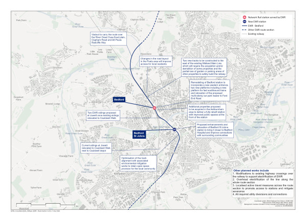
Figure 48: Map of the planned route of the project through Bedford
South Bedford and Bedford St Johns station
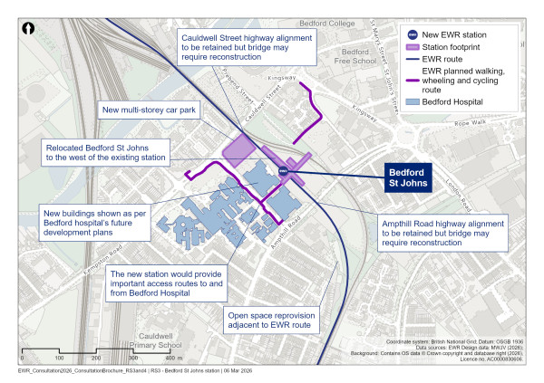
Figure 49: Map of the relocated Bedford St Johns station and south Bedford
What we presented at our previous consultation
We proposed relocating Bedford St Johns station closer to Bedford Hospital, between Ampthill Road and Cauldwell Street. This site has the space needed to accommodate the new EWR station and would also offer convenient access for patients, hospital staff, visitors travelling to Bedford Hospital, and the wider community. We proposed enhanced station facilities, which included a new multi‑storey car park to replace the existing Britannia Road car park.
What you told us
Many of you expressed support for the relocation of Bedford St Johns station, and some noted that the move aligns with Bedford Borough Council’s regeneration plans. You said it would be important to make sure the new station design prioritises accessibility, sustainability, connectivity to Bedford Hospital, and safety. You also wanted it to be well connected with wider transport networks, including with local bus routes, and with established walking, wheeling and cycling routes.
Some of you were concerned that the new station would be hard to reach for some people, as it would be on the other side of the tracks from Bedford Hospital. Some of you questioned whether the relocation was necessary, given how close it was to Bedford station.
Some of you felt the proposed multi‑storey car park would increase parking capacity, but others were worried that Bedford Hospital parking may be compromised by demand from rail passengers. Some of you were concerned about the visual impact of the proposed car park and you also requested that current parking capacity should not be removed until construction of the multi‑storey car park is finished.
Our latest proposals
Since our previous consultation, we’ve updated our proposals in the south Bedford area, including:
-
Realigning the track curve south of Bedford St Johns station to reduce maintenance on the railway. As a result we are making changes to the open spaces near the Cauldwell Community Centre
-
Revising the Bedford St Johns station design and aligning it with Bedford Borough Council and Bedford Hospital plans, including local regeneration priorities and the Elective Care Hub project
-
A new proposed location for the multi‑storey car park, accessed from a new traffic light‑controlled junction on Britannia Road
-
Further developing our plans to reduce the extent of roadworks in the area, including Ampthill Road and Cauldwell Street bridges
There are a range of challenges in this area which we need to balance to reduce the level of disruption caused. Our updated proposals reflect the outcome of further technical studies which considered opportunities to improve the design of the railway between the Sandhurst Road footbridge and the crossing of the River Great Ouse. The studies were informed by a topographical survey, updated industry standards, and also took account of feedback from previous consultations and stakeholder engagement.
The curve south of Bedford St Johns station
We’ve continued to develop our designs for the alignment of the tight radius curve south of Bedford St Johns since our previous consultation.
We assessed how the layout of the track affects how often it needs to be maintained, and the noise it produces. When the track has tighter curves, the wheels press harder against the rails and this causes more wear and creates more noise. By making the curve more gentle (flatter) reducing the curve of the track’s alignment, we not only reduce noise but the rails last longer, need less maintenance, and the railway operates more efficiently and safely.
In refining our proposals, we considered the effects of the track’s layout on important community assets, including the open space and playground next to Cauldwell Community Centre, and the charities based in the adjacent Raleigh Centre and Southway building. Protecting and enhancing these facilities is a key priority.
The flatter track layout would require land from the open space on the west side of the track. In order to replace the loss of some of this open space and impacts to the Cauldwell Community Centre playground, our proposals include acquiring land from the Raleigh Centre and Southway building, including areas of car parking and the Men in Sheds charity building. We would use this land to provide replacement open space, with the remaining existing open space to be extended and enhanced with tree planting, grassland and a new, improved play area.
Part of the existing Britannia Road surface car park would be used to create space for a new building for Men in Sheds, and to reinstate car parking for the Raleigh Centre and Southway building. Overall, following completion of the works, the amount of open space would be greater than what is there at present. Our proposals would provide a better and more accessible public park for the local community to enjoy, that can be used the whole year round.
On the east side of the track, we’ll plant new shrubs and foliage to help screen the new railway infrastructure, creating a visual and ecological buffer with the adjacent county wildlife site.
Noise mitigation would be provided on both sides of the curve. This is likely to be a noise barrier, but we’re carrying out further technical studies to confirm the right solution.
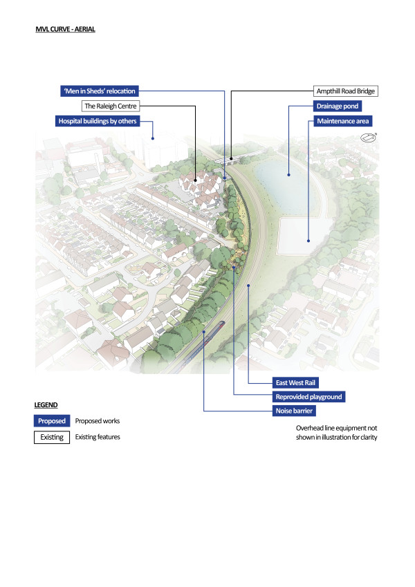
Figure 50: An indicative aerial illustration of the curve south of Bedford St Johns station
Bedford St Johns station and highways work
Since our previous consultation, we have assessed how the railway could best integrate with the emerging Bedford Hospital masterplan and wider development aspirations identified by Bedford Borough Council. Ensuring the station aligns with these plans is essential to achieving a joined‑up solution for the area.
The existing single‑platform station at Bedford St Johns would be demolished and replaced with a new two‑platform station 130 metres to the north‑west, bringing it closer to Bedford Hospital. The new station would be an important access route to and from Bedford Hospital for staff, visitors and patients, while also supporting the area’s regeneration.
As presented at our previous consultation, the proposed location for the new station remains between Ampthill Road and Cauldwell Street. However, the station building, concourse and facilities have been refined from our previous plans. We are working with Bedfordshire Hospitals NHS Trust, Bedford Borough Council and Network Rail to bring together development proposals for the area.
The relocated station would create improved opportunities to link trips with different modes of transport to the front door of Bedford Hospital and more convenient access to key employment sites nearby. This would allow development opportunities to the east of the railway too. Increasing travel by rail to Bedford Hospital and nearby employment areas may help to ease pressure on town centre parking and reduce demand for vehicle access.
The new Bedford St Johns station concourse would be elevated above the railway and would be accessible from both the east and west. Access would be provided via passenger lifts and a pedestrian footbridge. This footbridge would be accessible to people without train tickets, and would make local walking and cycling more convenient and direct, complementing Bedford Borough Council’s plans for housing and employment growth in the immediate vicinity of the station.
Our updated designs aim to strengthen pedestrian connections in the area. We are proposing a new pedestrian crossing on Britannia Road that would create a direct, welcoming gateway into Kings Place and towards the station entrance. Our designs would also widen sections of the existing footway on Britannia Road, where space allows. This widening of the footway would provide a more comfortable and accessible route between the station and the existing footways and bus stops on Kempston Road. We would also make it easier to get to and from the bus stops at Britannia Road and Kempston Place through improved signage to help direct station users to connect with the existing network of frequent bus services.
Alongside this, we’ve increased the size of the drainage pond proposed south of Ampthill Road to enable a reduction in underground drainage attenuation near Bedford St Johns station, maximising the potential for future development opportunities near the station.
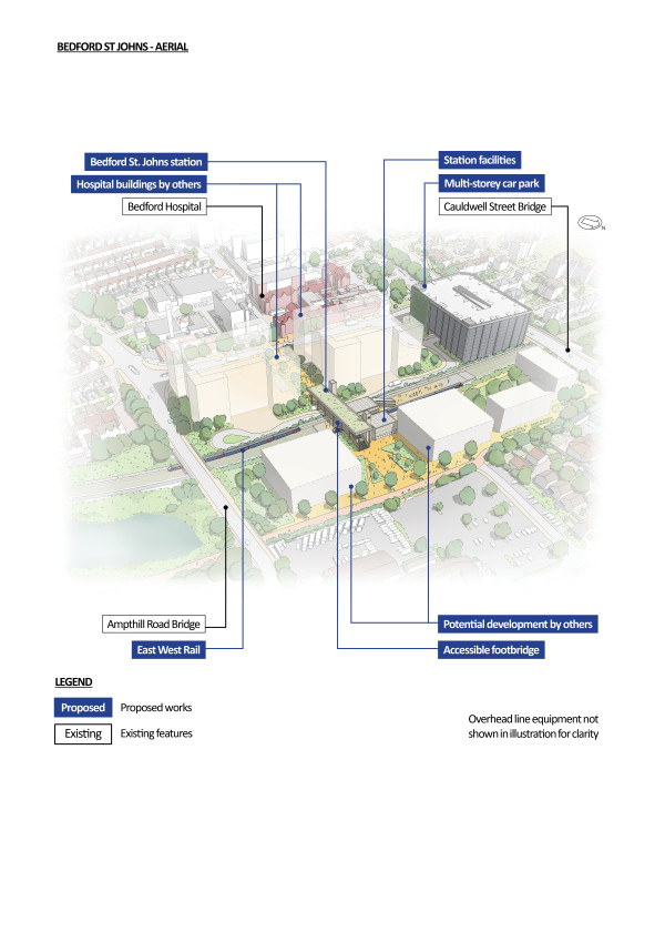
Figure 51: An indicative aerial illustration of the relocated Bedford St Johns station
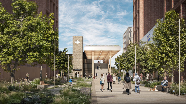
Figure 52: An indicative illustration of the relocated Bedford St Johns station
Ampthill Road and Cauldwell Street bridges
In our previous consultation, we said that the Ampthill Road and Cauldwell Street bridges might need to be rebuilt and raised to accommodate overhead line equipment. We’ve worked hard to explore how we can minimise the need to reconstruct Cauldwell Street and Ampthill Road bridges or realign the surrounding highways to avoid raising the height of these bridges. Avoiding major bridge works would significantly reduce cost, disruption and construction impacts.
The new Bedford St Johns station design has changed to include an island platform instead of side platforms. This design change, supported by updated surveys and industry standards, lowers the height of the railway compared with our previous designs. This would enable the tracks to pass under the highways and avoid the bridge columns at Ampthill Road and Cauldwell Street, reducing the likelihood of needing to rebuild these bridges.
We are currently assessing the bridges to see if they can remain in place while the track is lowered. Bridge strengthening works and changes to the parapets are expected to be required. By not raising Cauldwell Street, the permanent road closures and temporary diversion of Prebend Street through Bedford Borough Council car park, that we had previously planned, would no longer be needed. This would reduce the impact of the works on traffic in Bedford during construction, and the potential impacts to the entrance of the former Britannia Iron Works, a Grade II listed building.
Multi-storey car park
We’re proposing a new location for a new multi‑storey car park which better aligns with Bedford Hospital’s proposals. This would provide like‑for‑like replacement of Bedford Hospital car parking, which would be lost due to the railway alignment. This nine‑storey car park would be next to the junction of Caudwell Street and Britannia Road. The new car park would be accessed from a new traffic light controlled-junction on Britannia Road, south of the current junction of Cauldwell Street, Kempston Road and Britannia Road. The number of car parking spaces in the hospital area would be maintained during construction, as described further below within the approach to construction section for this area.
The revised location for the new multi storey car park, along with the associated works, would require the acquisition of eight residential properties at 1‑8 Crown Place, as well as the Crown Care Home. We have closely engaged with the affected landowners and the care home to support them through the acquisition process.
Approach to construction
The works associated with the realignment of the curve south of Bedford St Johns, the construction of the new Bedford St Johns station, and the structural modifications required to Cauldwell Street and Ampthill Road bridges, would require a construction compound which would be sited within the existing Britannia Road car park. We are proposing a phased construction, which would allow part of the existing car park to remain available, with additional parking provided south of Ampthill Road, on the east side of the curve. This would help to retain local parking throughout the works.
A second compound would be established within the parcel of unused Network Rail land situated south of Cauldwell Street, between the existing railway corridor and Melbourne Street car park. The compound would be accessed from Melbourne Street through the existing Melbourne Street car park entrance.
A revised temporary access into Melbourne Street car park is proposed to segregate construction traffic from car park users for the safety of motorists and to enable continued use of this car park during construction.
To reduce travel disruption, the existing single platform at Bedford St Johns station would remain open for as long as possible during the works.
Construction traffic would be directed to the A421 dual carriageway using several alternative routes, depending on temporary road closures and traffic management. The primary routes would use Britannia Road or Melbourne Street, connecting to Ampthill Road (A6). Other routes may include Bedford Road (B531) or Cardington Road (A603).
Share your feedback
As part of this consultation, we would like to hear your feedback on our revised proposals for Bedford St Johns station and the surrounding area.
We’re particularly interested in your views on the proposed realignment of the track south of Bedford St Johns station and the associated changes to the open space by Cauldwell Community Centre, and potential impacts on the Raleigh Centre and Southway buildings.
We’d also like to hear your thoughts on the revised Bedford St Johns station design, the new location for the new multi‑storey car park, and how we have integrated our plans with Bedford Borough Council and Bedford Hospital’s plans to optimise the development of the area.
Please also tell us what you think about our plans to reduce the extent of roadworks in the area, including Ampthill Road and Cauldwell Street bridges.
You can complete our online feedback form or find details of other ways to respond to our consultation in the How to respond to this consultation chapter.
Jowett Sidings and Cauldwell Walk
Our latest proposals
The EWR alignment cuts across the existing Govia Thameslink Railway stabling tracks at Jowett Sidings which would no longer be able to accommodate 12‑carriage trains. To maintain this provision for the parking of trains when they are not in service, we’re proposing to construct new sidings at Cauldwell Walk. The adjacent existing Bedford Carriage Sidings would remain.
Two of the five existing sidings at the Jowett site would be upgraded, shortened and retained for EWR use. to reduce empty train movements and provide more capacity for cleaning trains. The other three sidings would be removed. A revised access road and level crossing would be created within the Jowett site, accessible by railway staff only, to maintain access to the Bedford Carriage Sidings compound. Existing depot facilities would be reconfigured for the sidings that we keep. We are still exploring if this is the most suitable place for these sidings, with an alternative site near Stewartby still being explored.
New drainage attenuation would be required at Jowett Sidings ‑ between Bedford station and the crossing of the River Great Ouse to the south. Following previous proposals, most of the required attenuation has been moved north of Ford End Road and incorporated into the wider Bedford station development. Some attenuation would still be required around Jowett Sidings. As such, underground tanks are proposed within the Network Rail maintenance delivery unit car park to reduce the impact on the existing buildings and training facilities.
We would construct new sidings at Cauldwell Walk Industrial Estate to replace those displaced at Jowett sidings. The commercial properties currently along Cauldwell Walk Industrial Estate would be acquired.
The Cauldwell Walk site would include:
-
Five sidings, each able to stable 12‑carriage trains, together with depot facilities in a like‑for‑like replacement of the Jowett sidings
-
Three maintenance sidings and associated facilities to replace those impacted adjacent to Bedford Carriage Sidings
-
Passive provision for two more sidings, each capable of stabling 12‑carriage trains
The overall site footprint for proposals at Cauldwell Walk remains unchanged since our previous consultation, although the internal layout has been refined reflecting updated requirements.
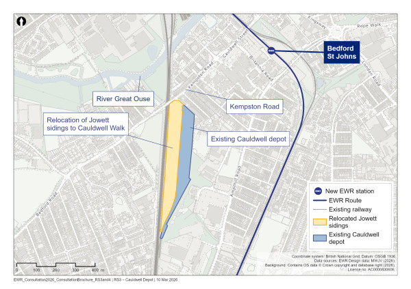
Figure 53: Map of the existing Cauldwell depot and relocated Jowett sidings
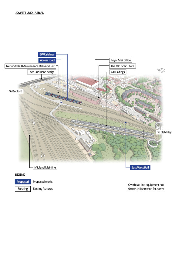
Figure 54: An indicative aerial illustration of the changes at Jowett Sidings
Approach to construction
The work needed to install the new Cauldwell sidings, along with the associated enabling work to the existing Midland Main Line (MML), which includes a new retaining wall, a new junction, and changes to the overhead line electrification and signalling systems, would be supported by a single main construction compound. This would be within the Cauldwell Walk Industrial Estate and positioned to reduce its impact on the permanent works.
Construction traffic serving the compound would be routed from the A421 dual carriageway via The Branston Way (A6/A428) and Bedford Road (B531).
Bedford station
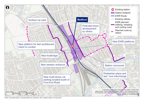
Figure 55: Map of Bedford station
What we presented at our previous consultation
At our previous consultation, we proposed a range of works at Bedford station, including the redevelopment of the station building, the creation of a new station plaza on the east side of the station, and improved access from the station to the riverside and town centre. We set out our vision to provide Bedford with a state‑of‑ the‑art transport hub that would connect with different modes of travel, including buses and walking and cycling routes.
We also proposed building new footbridges, two new platforms, and the provision of a new multi‑storey car park, up to eight storeys high, on Ashburnham Road.
What you told us
Many of you supported the redevelopment of Bedford station, noting the need for improved access to the station, accessibility and amenities for users. You also commented on the potential of our proposals to improve the profile of Bedford, attract more investment, and make the town a more appealing destination for work and leisure. However, a few of you questioned the cost and value of the investment, and whether the redevelopment would meaningfully address economic challenges in the town centre.
Some of you expressed concern about the construction works required being disruptive and potentially having a negative impact on traffic. There was also feedback regarding the proposed multi‑storey car park, including comments around the potential impacts on nearby homes, the increase in traffic due to the potential encouraged car use, and concerns around anti‑social behaviour. While the need for increased parking was acknowledged, alternative designs and locations were suggested.
Many of you supported the redevelopment of Bedford station and offered suggestions for features that could be incorporated into the design. These included a western entrance, improved cycle and pedestrian access, ample parking space and bus connections.
A range of views were given in relation to the proposals for changes to platforms. Several respondents supported the addition of two new tracks, which included support for the extension of platform 1A for Thameslink services. However, other respondents raised concern about the community impacts. It was suggested that existing infrastructure, particularly platforms 1 and 1A, may be able to accommodate the proposed EWR services, without the need for additional platforms or tracks.
Our latest proposals
In line with our ambitions to offer benefits to communities along the route as early as possible, our plans for Bedford now offer not only a more frequent and higher‑capacity service to meet the demand of the proposed Universal Entertainment Resort Complex to the south of Bedford, but also bring these benefits to the town earlier than previously envisaged. By changing our delivery approach, we intend that Bedford gets its new station ahead of the full‑completion of the project, and to start operating services ahead of the route‑wide service pattern. Since our previous consultation, we’ve updated our proposals for Bedford station, including:
-
Remodelling the station and eastern entrance to create a new accessible civic plaza
-
A new western entrance for the station
-
A new platform for fast southbound trains to London
-
A new location for the multi‑storey car park, to the west of the station on Ford End Road
Our updated plans are ambitious and intend to create long‑term benefits for Bedford town centre.
Set out below are the aspects of Bedford station we’re proposing to improve.
Remodelling the station and eastern entrance
We have further developed our proposal for a civic plaza outside the main (eastern) entrance of Bedford station, extending to Ashburnham Road. This would form a secure, well‑lit, important civic plaza in front of the station. The remodelled eastern entrance would connect to safe walking and cycling routes, making it easier for people to access the town centre and riverside area. It would also improve ease of navigation, helping people to get to the station from the town centre.
A new, elevated station concourse would be above the tracks, connecting passengers via stairs and lifts to all platforms, as well as the station’s two entrances.
The latest design for Bedford station, as presented in the You Said, We Did Autumn Update, now incorporates the acquisition and use of additional land and properties on Ashburnham Road that were previously excluded from the draft order limits boundary.
We recognise that these updated proposals mean a change from what was shared during the previous consultation. We also recognise the impact this has on property owners, some of whom were not previously affected. These changes result from more developed design work and are intended to reduce disruption during construction and provide long‑term benefits for Bedford, as well as the safe construction of the railway. We are committed to engaging with those who could be impacted openly to explain our proposals, to listen to their views and to work with them to understand and, wherever possible, reduce the impacts.
The long‑term benefits of the changes at Ashburnham Road include easier access to the town centre, better links to communities east of the station, and modern, more convenient car parking facilities.
The principal design considerations for the decision to require the land at Ashburnham Road are:
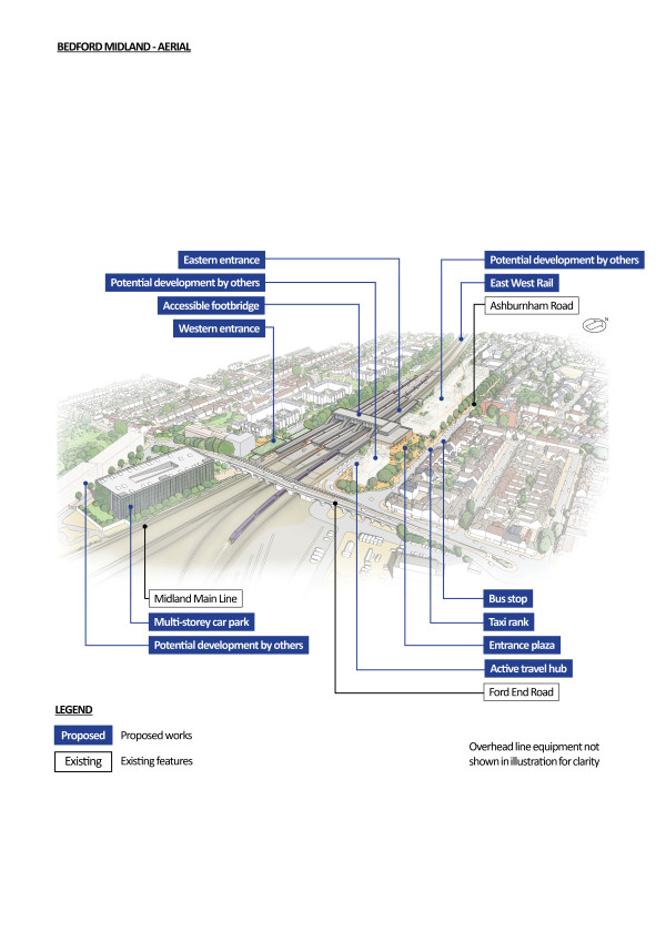
Figure 56: An indicative aerial illustration of Bedford station
Improved station and plaza design
The acquisition of additional land supports the provision of a modern station and public plaza, helping to improve connectivity, enhance the passenger experience and create a welcoming public realm. The design also supports future development opportunities and responds to feedback received in our previous consultation.
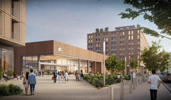
Figure 57: An indicative illustration of the view of the eastern entrance to Bedford station from the south-east corner of the new plaza
Health, safety and welfare provisions
Additional space would allow for safer segregation between construction activities and the operational railway and public areas, reducing the need for complex temporary works and minimising risks. Providing adequate welfare facilities for workers and safe logistics routes would further reduce the risk of accidents and incidents, aligning with industry best practice and Health and Safety Executive (HSE) guidance.
Stakeholder and community impact
Acquiring the additional properties on Ashburnham Road is essential so that we can provide redevelopment of Bedford station efficiently and with minimum disruption. Without these acquisitions, the redevelopment would be more disruptive for passengers and the surrounding area, with increased risk of failing to meet key operational and stakeholder requirements. Securing the necessary land would help to minimise service disruptions, reduce construction traffic on local roads, maintain reliable rail operations, and better meet the needs of passengers and stakeholders throughout the construction period. The proposed property acquisitions would shorten the duration for the construction of the station by over two years and increase the distance between adjacent properties and the live construction site.
This separation would help to reduce construction‑related noise, dust and vibration impacts. We recognise that these property acquisitions would have community impacts, including the loss of a doctor’s surgery, community centre, and emergency accommodation. We’re committed to working closely with affected communities and stakeholders to mitigate these impacts where possible and to support the local community throughout the process. More information on our approach to land and property, including support that may be available to those land and property owners and occupiers who could be impacted by our plans, can be viewed at eastwestrail.co.uk/land-and-property
A technical report describing more detail about the decision to acquire more land on Ashburnham Road is available on the EWR website at eastwestrail.co.uk/consultation2026
New western entrance
Following feedback from a range of stakeholders at our previous consultation, we’re proposing to add a new western entrance to Bedford station. This direct link, accessed from Kempster Close, would significantly improve access for residents in Queens Park and other communities to the west of the town. The western entrance would also connect to the relocated multistorey car park via an upgraded underpass beneath Ford End Road.
The entrance would be fully accessible, providing step‑free access to all platforms and include a new active travel hub, providing more space for bicycles, scooters, and cargo bikes. Most importantly, this new entrance would make rail travel easier, quicker and more appealing for residents and businesses. It would unlock shorter, safer journeys for anyone walking, wheeling or cycling, strengthen connections to key active travel routes, and ensure the station works better for growing communities on the west side of the railway. Existing bus services, the taxi rank, and other station car parking would remain on the eastern side, ensuring seamless interchange for all passengers.
We are working with Bedford Borough Council to encourage sustainable travel to the station and minimise the traffic impact on the network. The addition of a new western entrance would significantly reduce walking and cycling distances to the station and encourage travel by active modes.
By improving accessibility and reducing travel time, the new entrance would support local economic growth, encourage sustainable travel choices, and create a station that better reflects the needs of Bedford.
Building the western entrance would impact on Kempster Close on the west side of the railway. We would need to relocate a number of car parking spaces and the play area. Landscape planting including trees, hedgerows and grassland would be provided around the new station entrance and between the railway and the new play area and parking to screen the railway from the homes on Kempster Close. To protect residential roads from parking overspill, we would work with Bedford Borough Council to assess whether parking restrictions could be introduced on the west side of the railway.
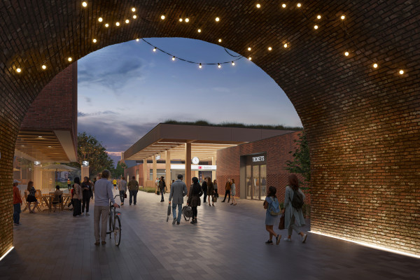
Figure 58: An indicative illustration of the view of the new western entrance to Bedford station from within the archway of the existing Ford End Road bridge
New platform for fast trains to London
We would provide a new platform for fast trains between London St Pancras and Sheffield. The new platform would allow fast trains to stop at Bedford, which would improve the town’s north‑south connectivity, and would enhance the interchange between East Midlands Railway and EWR.
The inclusion of this platform would keep the station open as much as possible during construction and would reduce our construction programme by over two years. This is because widening the platform provides the working room needed to enable elements of the large footbridge structure to be constructed during the day, reducing the amount of night‑time work.
Multi-storey car park
Following feedback from our previous consultation, we’re proposing a different location for the new multi‑storey car park, moving it from the east of the station to the west. This would avoid constraining space for new homes and businesses to the east of the station and would help to address concerns raised by residents on Ashburnham Road about impacted views. Moving the car park further away from Bedford Conservation Area would also reduce its visual impact. The relocated the car park would also better support placemaking around the station by creating more space for future improvements.
As part of our revised design, the multi‑storey car park, which we previously proposed to locate on Ashburnham Road, would now be located on land currently owned by Network Rail to the west of the station, to the south of Ford End Road bridge, and would be accessed from Ford End Road. The multi‑storey car park would be up to six storeys high. The car park would include provision for cycle parking, electric vehicle charging, blue badge and accessible parking spaces, pick up and drop off points, and pedestrian areas.
We know that people living in the area are concerned about increased traffic congestion, and the potential for vehicles to cut through the Queens Park area to access the car park. Even without East West Rail, this congestion is expected to get worse in future as more homes and businesses are built and the population of Bedford increases. Our designs for the multi‑storey car park and surrounding roads will be informed by updated traffic modelling, which is currently being reviewed, to ensure we have fully considered and addressed these concerns.
This work includes carrying out detailed assessments of traffic impacts as part of our Transport Assessment, including how nearby junctions perform and road safety around Ford End Road. These findings will help us identify the right level of mitigation to test and develop through design. These mitigations could include adding to or amending traffic signals outside the town centre to help traffic flow more efficiently, or measures to protect residents in the Queens Park area from ‘rat‑running’.
We are keen to hear more from you regarding the types of mitigations you would like us to explore, or whether you would like us to continue exploring other potential car park locations with Bedford Council. We will continue to meet regularly with Bedford Borough Council and carry out further engagement with the community, to share the results of our traffic modelling and agree any proportional mitigation measures that may be needed.
We presented these proposals as part of Design Update Sessions in February this year. Feedback received at these events and in response to this consultation – including your ideas for how to improve traffic congestion in Bedford ‑ will help us refine our plans for car parking in the Bedford areas.
Highway works
We are proposing some highways works near to the station. To the south of Bedford station, designs at Ford End Road remain unchanged since our previous consultation, with one EWR track passing through each of two arches under the road. To the north of the station, Bromham Road bridge would be lengthened, as presented at our previous consultation, to cross the two new EWR tracks that would run adjacent to the MML. Bromham Road bridge would be temporarily closed during construction.
Walking, wheeling and cycling proposals
To the east of the station, a mixed‑traffic route with traffic calming along River Street would be created, connecting the cycling network on the River Great Ouse to Midland Road and Greyfriars, both of which would be improved for active travel as part of Bedford Borough Council’s Towns Fund projects. This would improve connectivity between Bedford station, the riverfront and Bedford town centre.
We would also improve the route along Ashburnham Road for walking, wheeling and cycling.
To the west, people would be directed along Hurst Grove, Crowe Road and Henley Road to access the station. This would include a mixed‑traffic route along Hurst Grove from the junction with Bromham Road, to the existing footpath connecting Hurst Grove with Crowe Road. This footpath would become a shared‑use path and connect with a mixed‑traffic route along Crowe Road and Henley Road.
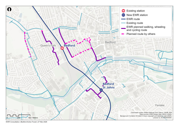
Figure 59: Map of planned active travel routes in Bedford
Approach to construction
Our previous construction proposals have been reviewed in detail, including by independent advisors, and the constrained footprint of the existing station means additional space is necessary for construction compounds, logistics and workforce facilities. Acquiring properties on Ashburnham Road enables the establishment of adequately sized compounds, safe and efficient logistic routes, and parallel construction activities. The acquisition of this extra land is necessary for meeting programme milestones, reducing disruption and keeping workers safe. We assessed alternative options, but have found that these were not feasible solutions which would allow us to undertake the work we need to do at Bedford station.
To significantly upgrade Bedford station and make the associated changes to the operational railway, a main construction compound would be required adjacent to Ashburnham Road, within the existing station car park. The access point for this compound would be from Ashburnham Road.
Two satellite compounds would be needed to the west of the railway. The first would be accessed and located at, or close to, Kempster Close to support construction of the new western station entrance. The second would be located to the south of Ford End Road, within existing Network Rail land, and accessed from Ford End Road. It would support provision of the proposed new multi‑storey car park, access road, and associated works.
Construction traffic from the main Bedford station construction compound would be routed to the A421 dual carriageway from Ashburnham Road. From there, construction vehicles would either travel west via Bromham Road and Preston Way/ The Branston Way (A6/A428), or east via Bromham Road, Goldington Road (A4280) and Saint Neots Road. The precise routing would depend on the road closures which are required for the Bromham Road bridge modifications, so that traffic flows remain acceptable during construction.
Our work at Bedford would be shaped by the need to make changes to existing highways structures in a way that reduces traffic disruption. It would also be driven by the relocation of Jowett sidings and the complex redevelopment of Bedford station and its facilities.
Share your feedback
As part of this consultation, we would like to hear your feedback on our proposals to redevelop Bedford station including the proposal for a new civic plaza, remodelling the eastern entrance to the station, a new western entrance, a new platform for fast trains to London, and a new location for the multi‑storey car park.
You can complete our online feedback form or find details of other ways to respond to our consultation in the How to respond to this consultation chapter.
North of Bedford
Our latest proposals
The railway would continue north in a cutting on the east side of the existing MML, passing beneath Bromham Road. The existing Bromham Road bridge would be extended eastwards to accommodate the two new EWR tracks. The new two‑track railway would run parallel with the existing four‑track MML north of Bedford station, creating a six‑track corridor for 900 metres alongside the Poets area of Bedford and the University of Bedfordshire’s Alexander Sports Centre. Noise mitigation would be provided on the west side of the track from Bromham Road to the north of Beverly Crescent.
The widening of the railway corridor, using a retained cutting, to the north of Bedford would require property acquisitions to safely build the railway. In response to concerns about the impacts of building the six‑track section of the route out of Bedford, we’ve confirmed our designs using revised survey data. This has not changed the land that we need to build and operate the railway.
Changes suggested in our previous consultation included reviewing the highway arrangements at the corner of Spenser Road and the corner of Milton Road and Sidney Road. Our latest design no longer includes the acquisition of 5 Milton Road and the permanent cul‑de‑sac arrangement outside Spenser Court due to the incorporation of one‑way systems.
The widening of the rail corridor would require the following road changes in the area, including changes to our proposals since our previous consultation:
-
Milne Row and Chesterton Mews would be shortened. Temporary cul‑de‑sacs would still be necessary during construction, which would be similar to the permanent designs previously proposed. We would aim to quickly reinstate the road once construction has ended.
-
Spenser Road would be narrowed to a single carriageway near Spenser Court. It would become one‑way from Spenser Court to Milton Road. Milton Road would be narrowed to a single carriageway between Spenser Road and Sidney Road. It would have a one‑way gate at the southern end of Sidney Road.
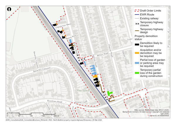
Figure 60: Map of temporary changes to the road layout around Milton Road, Spenser Road and Sidney Road
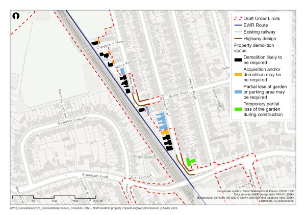
Figure 61: Map of permanent changes to the road layout around Milton Road, Spenser Road and Sidney Road
There are several potential options for how these one‑way systems could work, and we’ll engage with residents and Bedford Borough Council as we continue to develop our designs.
The construction of the new tracks would need a strip of land to be acquired from the University of Bedfordshire’s Alexander Sports Centre. This would likely require the sports pavilion to be relocated within the existing sports centre grounds.
The works in the Poets area north of Bedford station would affect the views of some residents with the loss of trees, lineside vegetation, and buildings opening up views of the railway. The two new tracks would bring the railway closer to properties which could result in operational noise impacts, especially where demolitions newly expose properties to the railway.
Areas of tree planting would be provided in place of demolished properties to reduce the visual impact. Noise mitigation would be provided on the east side of the track from Bromham Road to the Alexander Sports Centre, and adjacent to the Poets area. We would work with the communities impacted by these changes as we work to create mitigations and planting that suits the characteristics of the local area, reflects the heritage, and is representative of those who live there.
The proposed EWR route would branch off from the MML near the UK Power Networks (UKPN) substation on Cut Throat Lane at Fairhill. We would move this substation as it is too complicated to reconfigure the current site and we’re exploring options with UKPN. Landscape planting would surround the UKPN facility.
The drainage attenuation pond west of the MML proposed in our previous consultation has been moved to be adjacent to the UKPN facility, east of the MML. This would maximise the development opportunity to the west of the MML, and reflects feedback received at the previous consultation.
Approach to construction
The construction in this area would be served by a compound within the grounds of the existing Alexander Sports Centre playing fields. Access to the compound would be from the north via Cut Throat Lane. Construction traffic would be routed to the A421 dual carriageway via Great Ouse Way (A6), Bromham Road (A4280) and The Branston Way (A6/A428). A haul road would be along the length of the railway between Bromham Road (A4280) and the UKPN substation at Fairhill to support the provision of the new twin‑track railway.
River Great Ouse area
Our latest proposals
The railway would pass under the A6 Great Ouse Way, which would be realigned. This realignment is necessary to ensure sufficient separation between the road and railway as it would now pass over the new EWR track and the existing railway (MML). The realignment has been moved closer to the current alignment, compared to previous designs, to reduce the extent of land needed.
The railway would rise onto the new 1.1km (0.7 miles) long River Great Ouse viaduct to the north of the Great Ouse Way (A6). The viaduct would be up to 18 metres high at deck level. It would cross over the River Great Ouse twice, as well as the Paula Radcliffe Way (A6). The design of the viaduct requires the existing electricity transmission lines in north Bedford to be rerouted across the Paula Radcliffe Way (A6) to the west of the route. The viaduct would be designed to draw on Britain’s proud railway heritage and the tradition of viaduct structures that have shaped our railway network for generations.
Large areas around the viaduct would be provided for landscaping, enhancement, hedgerows, as well as wet grassland within the floodplain to enhance biodiversity and habitats. A further area of grassland planting is proposed to the west of the MML and to the south of Bromham Lake Local Nature Reserve. Three flood compensation areas would be provided to the north of the viaduct and to the south‑west of Clapham.
Approach to construction
The works within the Great Ouse area comprise two principal elements. The first involves the realignment of the existing Great Ouse Way (A6), including the construction of new bridge structures over the MML and the new EWR twin‑tracks. The second involves construction of the new viaduct, which would span the River Great Ouse at two locations, as well as the existing Paula Radcliffe Way (A6) and Clapham Road.
For the realignment of Great Ouse Way (A6), construction compounds would be established on the east and west sides of the MML. The eastern compound would be accessed from the existing Clapham Road roundabout, while the western would be accessed from the existing Great Ouse Way roundabout. Construction traffic for both would follow similar routes, connecting to the A421 dual carriageway via Great Ouse Way (A6), Bromham Road (A4280), and The Branston Way (A6/A428).
To support viaduct works, four compounds would be created along the viaduct alignment. The first two would be located adjacent to, and directly accessed from, Paula Radcliffe Way. Construction traffic for these compounds would also be routed to the A421 dual carriageway using Great Ouse Way (A6), Bromham Road (A4280) and The Branston Way (A6/A428).
A third compound would be located between the River Great Ouse and Clapham Road. A fourth compound would be to the east of Clapham Road and would support construction of the northern abutment of the viaduct, as well as the associated earthworks and access roads for the Clapham Green to Colesden route section. Both of these compounds would be accessed directly from Clapham Road, with construction traffic again routed to the A421 dual carriageway via Great Ouse Way (A6), Bromham Road (A4280) and The Branston Way (A6/A428).
This is where the Bedford route section ends. The railway would then transition to the Clapham Green to Colesden route section.
Clapham Green to Colesden
East West Rail (EWR) would operate from Clapham Green to Colesden on this 12km (7 mile) route section. This section starts at Clapham Road, south‑east of the village of Clapham, and ends at South Brook, Colesden. We would build a new two‑track railway through this route section with overhead line electrification.
This chapter presents our updated proposals for the Clapham Green to Colesden route section.
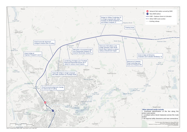
Figure 62: Map of planned route of the project from Clapham Green to Colesden
Clapham Green and Brickhill
Our latest proposals
After leaving the viaduct crossing the River Great Ouse, the railway would continue northwards towards Ravensden before passing around the northern edge of Brickhill. Since our previous consultation, we have refined our drainage and access routes at the viaduct which means there is no encroachment into the proposed new Bedford Greenacre Independent School development. Views would be maintained along the river and Clapham Road and we would also create space for new planting.
The railway would enter a cutting, passing beneath Carriage Drive and between Clapham Park and the Bedford and County Golf Club. Since our previous consultation, we have responded to concerns about the size and scale of this cutting by moving the alignment of the railway between Clapham Green and Ravensden Brook to the east, where it runs alongside Bedford and County Golf Club. This has allowed us to reduce the depth of the cutting by building the railway at a lower point on the hill. This change has also increased the distance of the railway from the Bedford and County Golf Club and other development land. This has allowed us to keep more hedgerows, alongside other mitigation, which would include grassland with scattered trees and the use of sensitive landscaping.
At Carriage Drive, the railway cutting would be 2.4 metres shallower than previously presented. This change would require the road to be lifted by up to 1 metre to cross over the railway on its current route, while reducing the width of the cutting. This would minimise the impact on this tree lined avenue and the parkland setting of the Grade II listed lodge at Clapham Park. It would also allow us to provide additional landscaping and tree planting around the cutting and bridge to enhance the existing trees and habitat connectivity.
We would need to divert or modify several public rights of way in the Clapham and Brickhill area to maintain connectivity across the railway, and we’re proposing two new bridges in this area to address this and ensure communities and businesses stay connected.
The proposed footbridge for Clapham Footpath 5 and 6 is now 50 metres north of the location previously presented. This would include planting, making it a green bridge, and it would therefore be larger than previously proposed. There would be planting directly on the bridge to support connectivity across the railway for a range of protected species including small mammals. This would also directly mitigate the impact of separating the Clapham Park Wood and Twin Wood ancient woodlands. We’ve also included planted areas on the approaches to, and around, the footbridge within our designs to further support ecological connectivity and help minimise the visual impact of the structure.
The location of the Brickhill Bridleway 54 has also moved following the change to the railway alignment described above. We have revised its approach on the east side to tie in more directly with Brickhill Bridleway 55 and onto Clapham Bridleway 29. This new location also directly avoids a parcel of deciduous woodland priority habitat and provides an access route for agricultural land separated by the railway.
Clapham Footpath 9, which runs between Carriage Drive and Clapham Park, would be closed. Existing users of this footpath would be diverted via Clapham Footpaths 8 and 24.
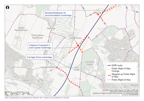
Figure 63: Map of public rights of way changes around Clapham Green and Brickhill
Ravensden
Our latest proposals
The railway would cross Renhold Brook via a bridge and then bear eastwards to pass Highfield Farm and Gray’s Hill Farm, mostly in a cutting.
As outlined above, since our previous consultation we’ve reduced the depth and width of the cutting by moving the railway alignment between Clapham Green and Ravensden Brook to the east, to a lower point on the slope.
Flood compensation areas would be included around the banks of Renhold Brook. Further mitigation would include grassland and woodland planting, which would help reduce the noise and visual impacts of the railway on nearby listed buildings.
A new access track for maintenance vehicles would be provided to the north of Highfield Farm to avoid the farmyard. Existing access to the farm would be retained under the Renhold Brook bridge for small vehicles only, and a new bridge would be constructed at Brickhill Bridleway to enable access to fields on both sides of the railway for agricultural vehicles.
Following further design development, we are no longer proposing a bridge in the Graze Hill area. This is because we have raised the railway alignment to reduce the cutting depth and associated construction impacts. Graze Hill would be severed by the railway line, with access maintained as far as the point of access to the closest properties on either side of the railway. To mitigate the impact of this closure and maintain active travel routes, we would divert vehicular traffic via Thurleigh Road and provide two new bridleways which could be used by those walking, wheeling, and cycling, as well as equestrians.
The first bridleway would be provided alongside Renhold Brook, which would link the south side of Graze Hill and Brickhill Bridleway 54 to Ravensden Bridleway 56. The second new bridleway would link Ravensden Bridleway 4 to Graze Hill, north of the railway, running parallel to Thurleigh Road within the field. This would cross under the track viaduct and then join the existing alignment of Ravensden Footpath 47, which would convert the footpath into a bridleway. This link would provide onward connection, via Graze Hill, to Ravensden Bridleway 10 and Ravensden Footpath 49 to the north of the railway. This new bridleway route would also replace existing Ravensden Footpath 5 and Footpath 46.
At Thurleigh Road, where we had previously planned two smaller bridges and a large embankment, we would now construct a single viaduct to cross both the highway and Ravensden Brook. The height and form of the viaduct structure, with wide set pier spacing and clear height above the ground, would preserve existing views that the embankment and small bridges would have blocked. We had previously presented a slight highway realignment at Thurleigh Road. Under our updated plans, this would not be needed and connectivity would be maintained meaning fewer roadworks and disruption during construction of the railway.
At Ravensden Brook, the viaduct piers would be positioned to minimise impacts on the floodplain and waterside habitat, helping to maintain continuous habitat along the river corridor. A small floodplain compensation area would be created on the banks of Ravensden Brook, complemented by additional landscape planting to support ecological connectivity with Great Wood ancient woodland across the railway.
The railway would then pass to the north of Ravensden along a series of embankments and cuttings. The railway would cross beneath the B660 Sunderland Hill in a cutting, and the road would be reinstated on a new bridge over the railway at its current position, just north of Grange Farm.
We have amended our design to minimise impacts on the Growing Beds Recycling Services facility. This includes moving a farm access track on the north side of the facility and relocating a construction compound and environmental mitigation planting.
We have also moved a telecommunications compound 400 metres to the east and north of the railway and added a road rail access point to the west of the Growing Beds Recycling Services facility. We would also build new drainage ponds to capture surface water from the rail corridor and highways.
We would need to divert or modify several public rights of way in the Ravensden area to maintain connectivity across the railway. Ravensden Byway Open to All Traffic (BOAT) 61 would be diverted along the south side of the new railway to join with Sunderland Hill. To the east of Sunderland Hill, a new footbridge would be provided for users of Ravensden Footpath 35. This footbridge would be positioned 250 metres further west than presented at our previous consultation, to offer a more convenient crossing point for pedestrians using Ravensden Byway BOAT 61 and to sit more level in the landscape.
A watercourse on the east side of Sunderland Hill would cross under the railway in a culvert, with floodplain compensation included along the bank sides along with landscape planting.
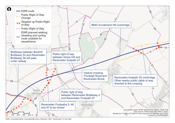
Figure 64: Map of planned active travel routes for the Ravensden area
Wilden
Our latest proposals
At Wilden, we’ve lowered the railway and reduced the earthworks in the South Brook area. This was made possible by diverting Shrubbery Lane to the east to cross under EWR at the South Brook West viaduct. This viaduct would cross over Shrubbery Lane, South Brook and the Rectory Farm access track. Access to Wilden Cricket Ground would be moved slightly to tie‑in to the realigned Shrubbery Lane.
At South Brook the viaduct piers would be spaced to minimise impacts to the river, floodplain and waterside habitat, providing habitat continuity along the river. A small floodplain compensation area would be included on the bank of South Brook and additional landscape planting would be incorporated around this providing better connectivity with existing areas of woodland.
The railway would then pass 250 metres to the north of Wilden village in a cutting. Chequers Hill would be reinstated onto a new bridge over the railway at its current position. Colesden Road would be realigned along the north side of the railway connecting to Chequers Hill. This avoids the need for a bridge over the railway as previously proposed, and removes a prominent feature in the landscape. The section of Colesden Road on the south side of the railway would become a local access road.
Wilden Footpath 22 would be closed, close to the point where it meets the railway track, with access diverted to the west along Wilden Footpath 15 towards the new Ravensden Footpath 35 bridge. A new footpath would be provided to the north of the railway linking the Ravensden Footpath 35 bridge with Shrubbery Lane. Wilden Footpath 16 would be diverted to follow the realigned Shrubbery Lane under EWR to the west of the South Brook. Wilden Footpath 24 would be diverted alongside the south of the railway and connect in with the Chequers Hill bridge to cross over the railway.
Wilden Footpath 27 would be diverted via Wilden Bridleway 33 and Wilden Footpath 34, using a new public right of way via the field north of Wilden Village Hall. We are no longer proposing a bridge for Wilden Footpath 27 to cross over the railway due to the diversion.
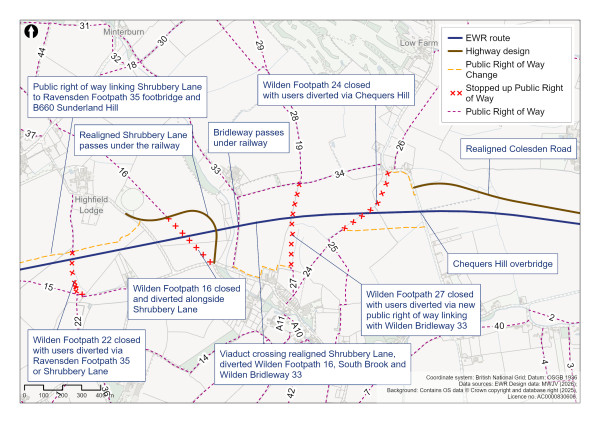
Figure 65: Map of planned active travel routes for the Wilden area
Colesden
Our latest proposals
The railway would pass to the south of Colesden in a shallow cutting, gradually rising onto an embankment as it continues eastwards. We would build two passing loops to the south of Colesden village, one on each side of the railway, to allow faster trains to overtake slower services. The passing loops would be set within shallow cuttings, alongside landscape mounds and tree planting to provide screening and mitigate for the loss of local habitats.
The railway would then transition onto an embankment, gradually increasing in height before crossing over South Brook on a viaduct, where this route section would end.
Wyboston, Chawston and Colesden Bridleway 16 would be diverted to a new bridge over the railway, which would be built mid‑way along the new passing loops. This bridge includes a planted section to support wildlife connectivity across the railway. We would strengthen the connectivity between the new bridge and existing habitats by planting trees and hedgerows to screen views of the bridge. Users of Wilden Bridleway 1 and Wyboston, Chawston and Colesden Footpath 15 would also be diverted to cross the railway on the green bridge. The green bridge would provide agricultural access to severed land south of the railway.
At South Brook, the piers of the South Brook East viaduct would be spaced to minimise loss to floodplain and waterside habitat and provide habitat continuity along the river. A small floodplain compensation area would be included on the bank of South Brook and additional landscape planting would be incorporated to support wildlife connectivity across the railway.
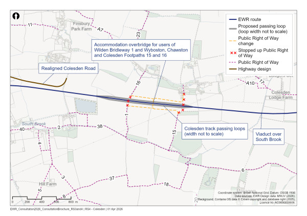
Figure 66: Map of planned active travel routes for the Colesden area
Approach to construction
Five main construction compounds are proposed within this route section, each with direct access from the public highway at Clapham Road, Sunderland Hill, Shrubbery Lane, Chequers Hill, and Colesden Road.
Nine additional satellite compounds would support the works. These satellite compounds would primarily facilitate earthworks movements and the construction of smaller structures, such as footbridges. Three of these satellite compounds would serve the same asset and would be located in close proximity to one another on both sides of the railway.
Since our previous consultation, the construction compounds and working areas, including service roads, have been further developed to minimise the effects to the landscape setting and sensitive ecological habitats and areas of archaeology. For example, in the Clapham Green area, we’ve relocated construction compounds from the west to the east side of the proposed railway to reduce impacts on archaeological assets and agricultural holdings.
Construction traffic routes would vary throughout the construction period, depending on road closures and associated diversion requirements. In general, construction traffic would be routed towards the A421 dual carriageway to the south and the A1 to the east.
In addition to the main and satellite construction compounds, several temporary stockpile areas would be located along the route section. These areas would provide adequate capacity for the segregation and storage of excavated soils and engineering materials, support the efficient construction of cuttings and embankments, and maximise the reuse of materials wherever practicable.
The details and locations of all construction compounds and associated stockpile areas within this section of the route are illustrated in the accompanying plans.
This is where the Clapham Green to Colesden route section ends. The railway would then transition to the Roxton to east of St Neots route section.
Roxton to East of St Neots
The East West Rail (EWR) route section between Roxton and east of St Neots is 10km (6.2 miles) long. It starts at South Brook near Roxton and ends at the new A421 dual carriageway/Cambridge Road junction to the east of St Neots.
We would construct a new two‑track railway through this section and build a new station at Tempsford which would provide an interchange between EWR and the East Coast Main Line (ECML). The new railway would include overhead line electrification from Bedford as far as Tempsford before relying on batteries on board the trains.
This chapter presents our updated proposals for the Roxton to east of St Neots route section.
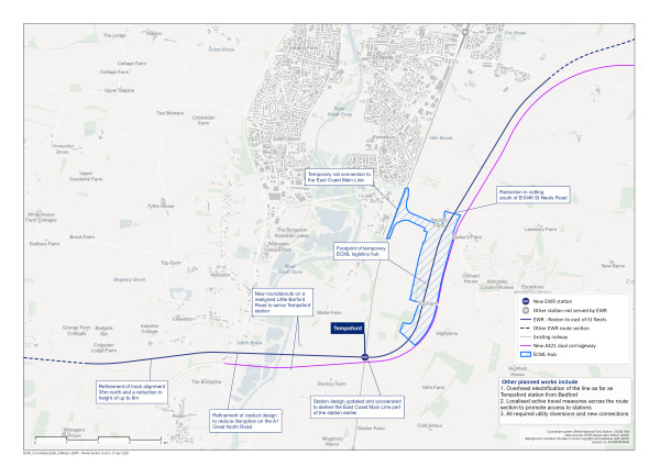
Figure 67: Map of the planned route of the project from Roxton to the east of St Neots
Roxton and the Ouse Valley
Our latest proposals
After crossing over South Brook on a viaduct, the new two‑track railway would operate on an embankment for 1km (0.6 miles) before going onto a viaduct to cross Roxton Road, the A1 Great North Road and the River Great Ouse.
Since our previous consultation, we have reduced the proposed height of the railway between South Brook and Roxton Road by up to 8 metres. We have achieved this through a combination of changing the vertical alignment of the track and moving the track 35 metres further north. It would now cross Roxton Road at a lower point in the landscape, and the viaduct would extend further west to reduce the overall footprint of the railway. As a result, we would no longer require parts of back gardens from properties along Spinney Road. We would also retain more hedgerows and create woodland and grassland with scattered trees in this area.
We’re working with National Highways to consider the design of the viaduct where it crosses the A1 Great North Road to reduce disruption to road users during construction. The viaduct would pass over a significantly redesigned highway junction, with flyovers and underpasses. Our design principles will help shape our proposals for the viaduct. For example, we’ll consider how best to space the viaduct’s piers to reduce the visual impact of the structure, as well as how the form of the viaduct can place fewer supporting piers near the A1, reducing disruption during construction.
We are aware of the complexity of the flood risks in the area surrounding the River Great Ouse and our proposals include flood mitigation in the vicinity of the A1 Great North Road viaduct. Further mitigation would be included, such as grassland planting, to help support wildlife and improve habitat links.
Tempsford
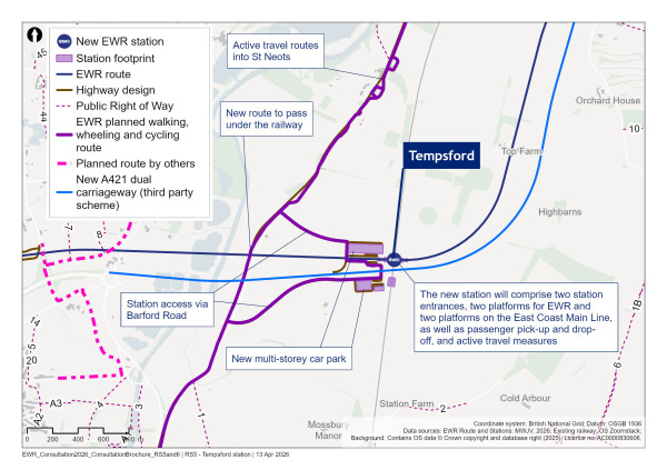
Figure 68: Map showing Tempsford station and surrounding area
Our latest proposals
The new station at Tempsford would serve both EWR and East Coast Mainline (EMCL) services and provide passenger interchange between them. It would improve rail access for existing communities, as well as provide for future residents of the proposed Tempsford New Town.
In January 2025, the government announced its intention to accelerate provision of the ECML part of the station to bring forward some of the benefits of the EWR project to Tempsford sooner than previously announced. We’ve been further developing the station design to account for this and are preparing a design which would enable the station to be completed in two phases to help people benefit from the station as early as possible.
Tempsford station would be located on land to the east of Little Barford Road, 1.8km (1.1 miles) north of Tempsford village. The EWR tracks would pass through Tempsford station and over the ECML on a viaduct, which would run parallel to and just north of the newly built A421 dual carriageway, currently being constructed by National Highways as part of the A428 scheme. Two platforms for EWR services would be located on the viaduct directly above the ECML, and the two platforms for the ECML would be located just to the south and beneath the A421 dual carriageway. We have also set aside space for two further additional platforms for ECML services that could be added in future as the town grows. Step‑free access would be provided throughout the station, and passengers would be able to switch between the two lines.
At our previous consultation, we proposed siting the new station entirely to the north of the EWR tracks and mostly west of the ECML. We’ve now extended the station to include a southern entrance to provide improved access on both sides of the A421 and support a phased opening. The southern part of the station, which we plan to open before the EWR route is complete, would be positioned to the south of the new A421 dual carriageway and would provide direct access to new platforms on the ECML.
The station interchange would include active travel facilities, car parks, bus stops and pick up/drop off facilities integrated with a potential new town centre. There would be north‑south connectivity via a new underpass beneath the new A421 dual carriageway, providing active travel and bus routes to and from the station.
We would provide dedicated access roads to both the north and south sides of the station from new roundabout junctions on the realigned Little Barford Road.
Active travel routes to link the new station to Tempsford village and St Neots would be provided, including potential routes alongside the River Great Ouse and Little Barford Road. These routes would connect with existing active travel infrastructure to the south of St Neots on the B1043 Barford Road and within Tempsford. We would modify Little Barford Road to improve bus access to Tempsford station.
Environmental mitigation would include areas of woodland planting and species rich grassland on the north and south access roads to the station.
The current A428 scheme flood compensation area would be removed from its current location as it would conflict with the EWR route. We would provide a new flood storage area to the north of the embankment to mitigate any impact on flooding as a result of the railway and the removal of the current flood compensation area. This would capture water upstream of the embankment and discharge at an appropriate rate to prevent increases in local flood risk.
As much of the railway would operate parallel to the new A421 dual carriageway, provided as part of the A428 Black Cat to Caxton Gibbet improvement scheme, we’ve designed our environmental mitigation proposals to complement those which are included in the National Highways scheme. For example, woodland and grassland planting has been designed to integrate with those that have been proposed as part of the A428 scheme. Habitats would be retained where possible and mitigation planting would address any potential loss of hedgerows.
Additionally, there would be planting and hedgerow creation to the north of the station area to create dark corridors for use by protected species, including bats. This would run in an east‑west direction and would link up with the dark corridor to the east of the ECML. A dark corridor is a double width hedge designed to act as an enclosed wildlife corridor to support protected mammal species.
Within this section there are a number of heritage assets associated with Little Barford village. These include the Grade II listed Little Barford School, Lower Farmhouse and 1‑4 The Bungalows, which front onto Little Barford Road, as well as potential buried archaeology. As we develop the design, we would continue to take account of these features and incorporate appropriate mitigation.
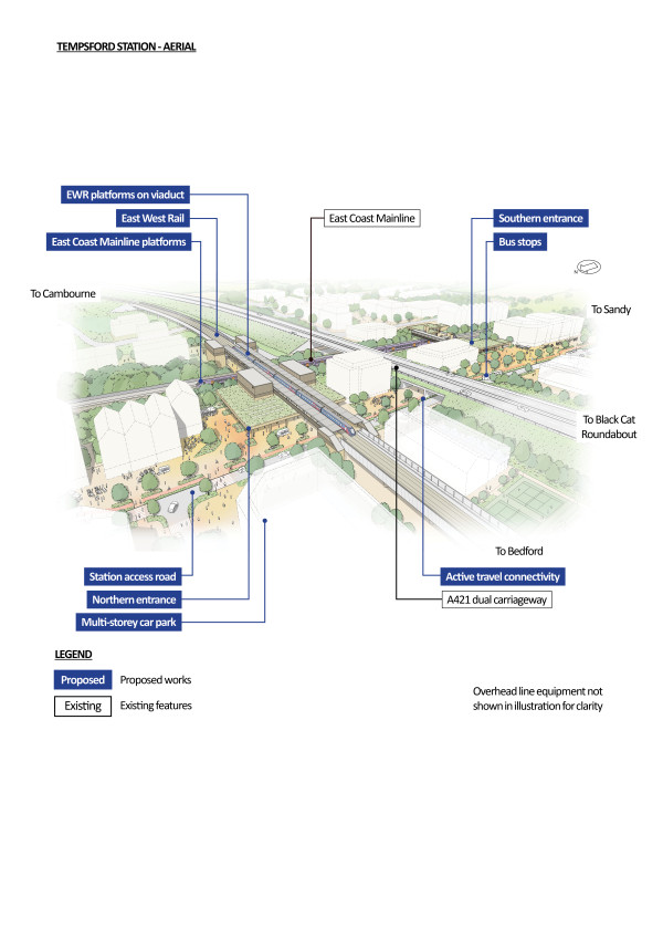
Figure 69: An indicative aerial illustration of Tempsford station
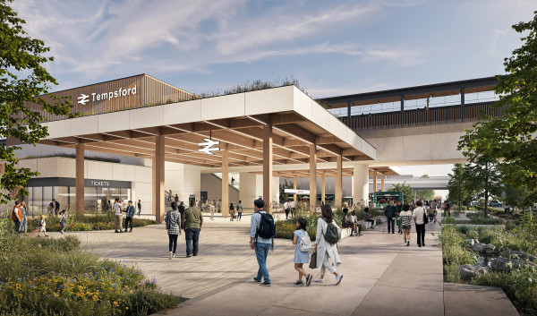
Figure 70: An indicative illustration of Tempsford station
East of St Neots and East Coast Main Line construction logistics hub
Our latest proposals
After crossing the ECML and to the east of Tempsford station, the railway would continue northwards. It would pass to the east of Little Barford and parallel to and west of the new A421 dual carriageway, heading towards the east side of St Neots.
At our previous consultation we put forward two location options for a temporary logistics hub to support construction. Our You Said, We Did Autumn Update confirmed that Option B has been selected, which would locate the temporary logistics hub to the east of Little Barford and the ECML.
We’ve refined the layout of Option B and how it links to the ECML by rail, taking account of feedback from our previous consultation. We’ve moved the rail link 130 metres south to reduce impacts on nearby properties. We’ve also relocated the entry road, which was previously proposed to be near the B1046 close to Potton Road, further south to use the bridge over the new A421 dual carriageway.
The hub would be used to support railway construction activities between Bedford and Cambridge. It would be accessed via a short section of railway that would provide a connection between the ECML’s southbound slow line and EWR. The hub would include sidings, facilities for the bulk storage of track ballast, and a range of construction plant and trains. This would enable ballast, sleepers, track and other materials to arrive by rail and be distributed along the proposed route, making the delivery of construction materials more efficient, reducing the amount of construction traffic and impacts on the environment and communities.
The hub would be 1.7km (0.9 miles) long and 150 metres wide. It would be removed once construction works have been completed, and the land would be reinstated.
At the southern end of the logistics hub, a double hedge has been incorporated to create a dark corridor for use by protected species, including bats. This would run in an east to west direction, linking with the mammal passage (a purpose‑built route for various species) beneath the proposed rail embankment and the existing mammal passage provided as part of the A428 scheme. This would connect with the dark corridor provided to the west of the ECML. New woodland, species rich grassland and ponds are proposed between the railway and the A421 dual carriageway.
Past the dark corridor, as the railway travels north, land associated with the temporary rail logistics hub would be reinstated with areas of woodland and grassland on both sides of the railway corridor once construction works have been completed. This has been designed to complement the mitigation proposed as part of the A428 scheme.
The construction of the temporary rail logistics hub would require Top Farm Brook to be realigned. This has been designed to link into the watercourse realignment provided by National Highways as part of the A428 scheme. The realignment would include woodland and grassland planting to provide habitat continuity along the watercourse for all species. A small floodplain compensation area would be included on the bank of Top Farm Brook and additional planting would be incorporated around this. Refinement of the design for the drainage ponds to the north of the logistics hub around Top Farm has enabled a reduction in permanent land take and reduced the loss of existing woodland.
Having passed the temporary rail logistics hub, the railway would continue northwards. It would pass beneath the B1046 St Neots Road in a 7 metre‑deep cutting. We’ve reduced the depth of the cutting here by an average of 2 metres to reduce its visual impact and help it better integrate into the surrounding landscape. The road would be carried over the railway on a new bridge, which would also provide emergency access provision for the new A421 dual carriageway.
Continuing north, the railway would rise onto a viaduct over Hen Brook and Abbotsley Footpath 9. It would then follow a short length of embankment before crossing over Wintringham Brook on a new bridge. Abbotsley Footpath 17 would be diverted to pass beneath this bridge. The A428 scheme has already consolidated public rights of way in this area and our proposals maintain the same two crossings for Abbotsley Footpaths 9 and 17.
Along this section, areas of grassland, woodland and scrub would be created on both sides of the railway corridor to help the railway blend into the surrounding area and improve east‑west bat flight corridors around Boys Wood and at Hen Brook. Wet grassland would be created near to Rockham Ditch and the River Great Ouse.
Mitigations and enhancements would be made to the Hen Brook corridor, which is an important crossing for various types of mammals, and would include the creation of wet woodlands, wet grasslands, and lowland meadow grasslands. We would also strengthen connectivity to the woodland surrounding the Abbotseley Golf Course. Floodplain compensation areas would be included on the banks of Hen Brook, Wintringham Brook and a tributary of Wintringham Brook. Areas of woodland planting, grassland and scattered trees would be created around these compensation areas.
Construction of the railway would require the demolition of a small number of farm buildings and silos at Top Farm, Little Barford and the demolition of a farm building close to the B1046 St Neots Road. We are working with the landowner who would be impacted by these plans to support them as we understand how we can compensate for these impacts.
Approach to construction
In addition to the railway logistics hub described above, four main construction compounds and eight satellite construction compounds would be required adjacent to the railway to support construction within this route section. The main compounds would act as bases for construction, while smaller satellite compounds would provide temporary support closer to specific work areas. The four main construction compounds would have direct access from Roxton Road, Little Barford Road and Potton Road (B1046).
Construction traffic routes would vary throughout the construction period, depending on road closures and associated diversion requirements. In general, construction traffic would be routed towards the new A421 dual carriageway and the A1. Due to the interface with the ECML and several existing major highways (such as the A1 and A421 dual carriageway), some night‑time, weekend and 24‑hour working would be required in this area.
This is where the Roxton to east of St Neots route section ends. The railway would then transition to the Croxton to Toft route section.
Croxton to Toft
East West Rail (EWR) would operate from Croxton to Toft on this 19km (12 mile) route section. This starts at the new A421 dual carriageway/Cambridge Road junction to the east of St Neots and ends at the B1046 Comberton Road. We would build a new two‑track railway along this section. Our proposals include the construction of a new station at Cambourne to the north of the town. The new railway would not include overhead line electrification in this route section and passenger trains would be powered by on‑board batteries.
This chapter presents our updated proposals for the Croxton to Toft route section. We are seeking your views in particular on our proposals for:
-
A new station at Cambourne, 700 metres west of the location proposed at our previous consultation
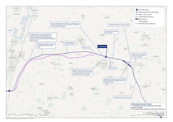
Figure 71: Map of the planned route of the project from Croxton to Toft
Croxton
Our latest proposals
The new two‑track railway would enter the Croxton to Toft route section, just east of St Neots. At this location, the railway would be in a cutting, heading north‑east. The railway would pass beneath B1428 Cambridge Road, which is currently being constructed by the National Highways A428 Black Cat to Caxton Gibbet improvement scheme. We would modify the B1428 and construct a new bridge to carry this road over the railway. We’ve changed the previously proposed alignment of the railway at this location to avoid the need to create an additional roundabout adjacent to the A421/B1428 Cambridge Road junction under construction by the A428 scheme.
The railway would continue eastwards in a cutting 5 metres deep, before crossing over Fox Brook on an embankment. It would then revert into a cutting to pass under Abbotsley Bridleway 18, which would be diverted onto a new shared‑use bridge for walkers, wheelers, cyclists and equestrians. Since our previous consultation, we’ve relocated this bridge 300 metres to the west and increased the width of the structure. The bridge would now have planting on it to allow small mammals to pass across the railway, mitigating the impact of severance between two areas of priority woodland habitat. We’ve included planted areas on the approaches and around the bridge to further support ecological connectivity and screen the structure.
The railway would then cross over Gallow Brook and enter a cutting to pass beneath Toseland Road. Floodplain compensation areas would be included around the banks of Gallow Brook. Additional mitigation would be provided, including riverside planting that connects habitats and supports wildlife movement. There would also be grassland, scrub and hedgerow planting between the railway and the new A421 dual carriageway.
At Toseland Road, we would provide a new emergency access from the A421 dual carriageway.
The railway would continue eastwards, mainly at existing ground level, operating parallel to, and north of, the new A421 dual carriageway. Taking account of feedback received at our previous consultation, we have increased the amount of landscape planting and habitat creation on the land between the A421 dual carriageway and the railway. This would provide a wildlife corridor, complementing the existing A421 dual carriageway planting scheme.
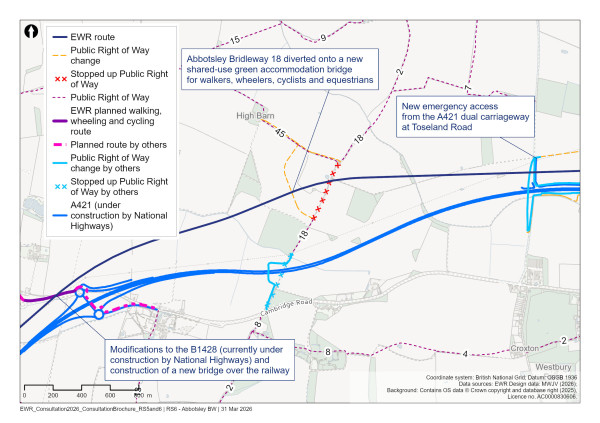
Figure 72: Map of the Croxton area
Eltisley and Cambourne
Our latest proposals
The railway would rise onto a low embankment to cross over West Brook. At our previous consultation, we proposed a diversion for Yelling Bridleway 3 and a farm accommodation access track for Fairview Farm within our design for West Brook crossing, under EWR. Our latest proposals would lower the height of the railway by 6 metres as it crosses over West Brook, meaning this crossing is no longer possible. To maintain connectivity, the farm accommodation access track and public right of way would be routed further east via a new bridge which would reduce the length of the diversion for users of Yelling Bridleway 3. The bridge would include planting to support protected species connectivity across the railway. We’ve included planted areas on the approaches to the bridge and around the watercourse within our designs to further support ecological connectivity and mitigate the visual impact of the bridge.
A tributary of West Brook would be realigned to the east before entering West Brook. We would provide a flood compensation area on both sides of the brook, and additional landscape planting would be incorporated around this, including waterside and grassland planting between the railway and the new A421 dual carriageway.
The B1040 St Ives Road would be realigned onto a new bridge to cross over the railway. Since our previous consultation we’ve lowered the railway and road bridge over the railway in this location by 1 metre. Landscape mitigation earthworks, including planting, would provide integration with the surrounding landscape.
The railway would continue eastwards, passing beneath the A1198 Ermine Street South, which would be realigned on a new bridge over the railway. Between B1040 St Ives Road and A1198 Ermine Street South, two watercourses would be diverted to cross under EWR. Flood compensation would be included on both sides of the realigned watercourses and landscape planting would be provided. This would include waterside and grassland planting, woodland and scattered trees for wildlife connectivity between the watercourses.
Since our previous consultation, we’ve slightly lowered the height of the railway where it crosses beneath A1198 Ermine Street South. To the east of A1198 Ermine Street South, the railway would continue east at existing ground level.
We are now proposing to divert Brockley Road/St Neots Road to the west of Cambourne along the north side of the railway. The road would then cross over the railway 1.4km to the east of its previous position, to join the existing A428 Cambourne roundabout junction.
We previously proposed a footbridge to carry Knapwell Footpath 5 over the railway. This is now proposed to be a bridge for all users, including motor vehicles. It would provide a western connection to Brockley Road and farm access to Coldharbour Farm. There would be a segregated shared‑use route for walkers, wheelers, cyclists and equestrians, which would connect with existing active travel routes, and would extend from the A428 Cambourne roundabout junction, over the bridge, and connect with Knapwell Footpath 5 and Elsworth Bridleway 4. Landscape mitigation earthworks, including planting, would be provided either side of the railway and the new bridge would have grass and tree planting on the slopes leading to it.
A dedicated active travel route would be created along St Neots Road, starting 1.3km west of the A428 Cambourne roundabout junction to tie in with an existing shared‑ use path and extending east as far as Broadway. Our proposals for the existing A428 Cambourne roundabout junction would include provision for an upgraded crossing for walkers, wheelers, cyclists and equestrians.
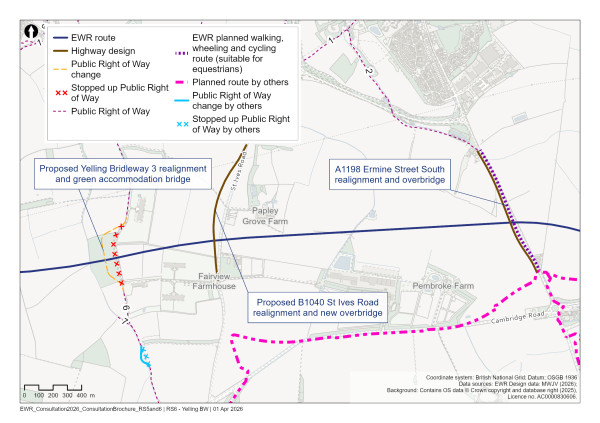
Figure 73: Map of planned active travel routes in the Eltisley area
We are proposing to use the existing and realigned sections of St Neots Road/ Brockley Road to access the new railway for maintenance instead of the previously proposed additional maintenance access tracks on both sides of the railway between St Neots Road and Knapwell Footpath 5.
In the Cambourne area, we would construct passing loops to allow faster trains to overtake slower trains. We previously proposed to build these on both sides of the railway between Brockley Road and New Inn Farm. Following the change to the proposed location of Cambourne station, as described below, the eastbound passing loop would be located 700 metres further west and the westbound passing loop 1.7km further to the east.
The new Cambourne station would be constructed on the north side of St Neots Road, which would provide communities with additional options for travel around the region and beyond, helping to cut journey times, reduce congestion and improve access to a wider range of destinations. The train journey from Cambourne to Cambridge would take just 15 minutes, compared with up to 50 minutes in rush hour on the road today.
Due to the new station location, we would also relocate our proposed shared use bridge for walking, wheeling and cycling across the existing A428, 300 metres to the west. The bridge would still provide direct connectivity between the station and Cambourne. In our new proposals this bridge would be located behind Cambourne Fitness and Sports Centre and provide links onto Monk Drive, Back Lane and Cambourne Road.
Our previous design proposed a dedicated bridge to divert Knapwell Footpath 8. Due to the new station location, we now propose to divert Knapwell Footpath 8 via the new underpass located at the station, which would be accessible to people without train tickets. We would also divert a watercourse alongside St Neots Road, which would pass beneath EWR close to New Inn Farm.
Continuing east, the railway would go into a cutting and pass beneath Knapwell Wood Road, which would be realigned 150 metres west of its current position onto a bridge above the railway. This bridge would include a planted section to provide habitat connectivity for mammals, including bats from the nearby Eversden and Wimpole Wood Special Area of Conservation. It would also provide habitat connectivity across the railway to Knapwell Wood, Honeyhill Wood, the Overhall Grove Site of Special Scientific Interest, ancient woodland and priority habitat woodlands in the area. We would provide landscape mitigation, including tree planting, around the green bridge to integrate shallower slopes, screen views of the railway and enable wildlife connectivity.
Provision would be provided along the eastern side of the bridge, providing connectivity to Knapwell Byway Open to All Traffic (BOAT) 7, which would be diverted from its existing route, 300 metres to the east.
Cambourne station
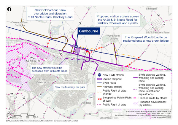
Figure 74: Map showing location of Cambourne station and planned active travel routes for the Cambourne area
What we presented at our previous consultation
At our last consultation, we presented our proposal to build a new station at Cambourne on the northern side of the A428 and St Neots Road, opposite Upper Cambourne and close to Knapwell Wood.
We proposed a station design that included:
-
A station building to the south of the proposed railway
-
A footbridge with stairs and lifts to provide step free access
-
Two platforms
-
An active travel hub with cycling facilities, bus stops and passenger car parking
What you told us
Several respondents expressed strong support for a new station at Cambourne, identifying a range of potential benefits including:
-
Improving rail connectivity to destinations such as Cambridge
-
Offering a sustainable transport option for residents and surrounding communities
-
Supporting the local economy and promoting growth
Feedback told us that respondents would like the station to be integrated with existing and proposed transport networks, including bus links and walking, wheeling and cycling routes. You also suggested a multi‑storey car park should be built to prevent overflow parking in nearby residential areas.
We also received feedback relating to the location of the station, with concerns raised that it would be too far from the town centre and cut off by the A428. There were suggestions to relocate the station further west, closer to the A428 Cambourne roundabout. Feedback was also provided about the station layout, with suggestions for accessibility features (the provision of lifts and ramps), toilets, changing facilities, cycle storage, and secure affordable parking with electric vehicle charging points.
Our latest proposals
We are consulting on our proposals for the new Cambourne station at a different location from the one we proposed previously.
Taking account of consultation feedback and engagement with key stakeholders, we’re now proposing a different location for the new Cambourne station compared to the design presented at our previous consultation. The new station would be located 700 metres west of the previous proposal, as presented at our You Said, We Did Autumn Update. To accommodate this change, we have also amended the locations of the active travel bridge over the A428 and the passing loops.
We’ve kept the main parts of the station design largely the same as presented at our previous consultation. This would include a station building, two platforms, active travel provision with cycle parking and facilities, bus stops, pick up and drop off facilities, and car parking, including a multi‑storey car park. The main change to the station is the proposal to provide an underpass beneath the railway, as opposed to a footbridge over the railway, with stairs and lifts to provide step‑free access up to the platforms. We’re continuing to liaise with stakeholders, including local authorities to understand how we could provide greater connectivity through the station, some of which would be subject to additional funding.
We’re continuing to explore opportunities with local property developers to further integrate the station with surrounding developments, which could result in some reconfiguration of station facilities.
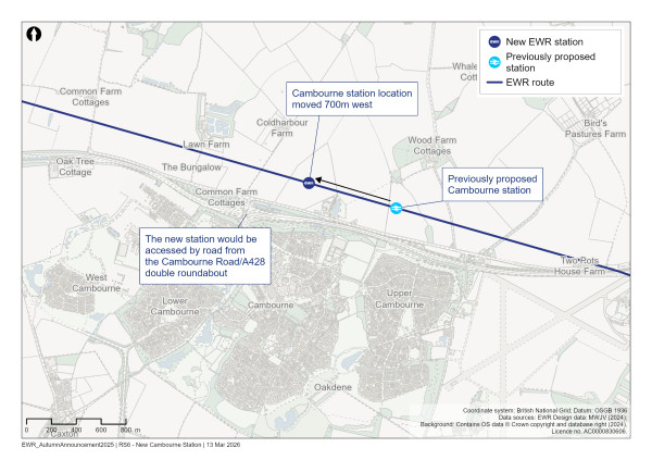
Figure 75: Map of Cambourne station, showing the change in location since our previous consultation
We’ve considered potential station locations along the proposed railway alignment in close proximity to Cambourne. In order to identify a preferred location we’ve considered a range of factors, including:
-
Environmental constraints, including proximity to existing properties, woodland, lakes, and local heritage
-
Opportunities to connect into the existing road network and walking and cycling routes
-
Closeness to existing and planned settlements
-
Potential to support future development
A technical report describing the option section process is available on the EWR website at eastwestrail.co.uk/consultation2026
Our preferred location for the station is slightly to the east of the A428 Cambourne roundabout, and 700 metres west of the previous location. It would enable a greater degree of development close to the station, better integrating with the potential future North Cambourne development. A proposed site at North Cambourne has been included within the draft Greater Cambridge Local Plan for consultation.
This site could enable the provision of approximately 13,000 homes as well as area for employment uses. It would also provide better access to the station for people walking from many key locations in and around Cambourne, including the centre, village college, and business park. The new station location would have a lower environmental impact than the previous location, as it would be further away from Knapwell Wood ancient woodland and reduce the loss of hedgerows.
The railway in the vicinity of the proposed station would be on a short length of embankment 2‑3 metres above ground level; a reduction of 1 metre to our previous consultation design. The proposed location for the station would require a change to the locations of the proposed passing loops and would enable an improved passenger timetable, while enabling freight services to continue to operate. The figure below shows the new proposed location of the passing loops.
Our previous design proposed a dedicated bridge to carry Knapwell Footpath 8 over the railway. Due to the new station location, we now propose to divert Knapwell Footpath 8 under the railway at the station, an active travel route which would also be available for people without train tickets. We would also divert a watercourse alongside St Neots Road, which would pass beneath EWR close to New Inn Farm.
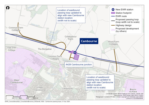
Figure 76: Map of the passing loops near Cambourne
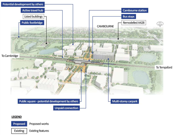
Figure 77: An indicative aerial illustration of Cambourne station
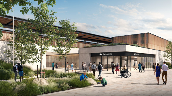
Figure 78: An indicative illustration of Cambourne station
The station would form part of an integrated transport network in the area, with easy connections to public transport and walking and cycling routes. We recognise the potential for Cambourne station to link with the proposed Cambourne to Cambridge Busway and we’re exploring how the station can facilitate any future expansion.
Our active travel proposals include the following:
-
A new cycling and walking path along St Neots Road
-
Upgrades to the existing east‑west gravel tracks south of the A428 to a shared‑use footpath and cycleway to improve connectivity between the station and Upper Cambourne, Lower Cambourne, and the town centre
-
A proposed shared‑use bridge for walking, wheeling and cycling over the A428 to provide a direct connection between the upgraded path south of the A428 and Cambourne station. This would be behind Cambourne Fitness and Sports Centre and provide links onto Monk Drive, Back Lane and Cambourne Road.
Share your feedback
As part of this consultation, we would like to hear your feedback on our revised proposals for Cambourne station.
You can complete our online feedback form or find details of other ways to respond to our consultation in the How to respond to this consultation chapter.
Bourn Airfield
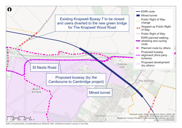
Figure 79: Map of Bourn Airfield
Our latest proposals
To the east of Cambourne and Knapwell Wood Road, the railway would enter into a deep cutting and tunnel from north of the A428. The tunnel would then emerge in a deep cutting to the east of Highfield Caldecote. The 1.4km (0.9 miles) tunnel would pass under St Neots Road, the A428, Wellington Way, the proposed Cambourne to Cambridge busway, the north‑east corner of the proposed Bourn Airfield development and Highfields Road.
At our previous consultation, we proposed to construct this tunnel using a cut and cover method, requiring significant works at the surface. As reported in our You Said, We Did Autumn Update, having listened to feedback and undertaken further analysis, we now propose to construct this tunnel using a mined method that would require incoming utility supplies such as water and power. This would avoid the need for significant works at the surface, including road diversions. It would also reduce disruption to the proposed Bourn Airfield development and would have less environmental impact, including on nearby woodland and groundwater, and this change would have a lower overall construction cost. In addition, this would avoid demolitions at Two Pots House Farm and a residential property at St Neots Road.
Compared to the previous tunnel alignment, we’ve moved the western tunnel portal slightly eastwards and repositioned the western portal further away from St Neots Road. We’ve also moved the proposed position of the eastern portal to the south‑east to increase the distance from Waters Wood. This provides room for additional environmental mitigation planting, connecting priority habitats. This would help reduce the impact of the wide cutting on wildlife movement, particularly for protected species. We would carry out landscape screening earthworks at both ends of the tunnel and the approaches, which would also be planted with grass and trees to reduce visual impacts. The eastern portion of the tunnel intersects the existing Caldecote Footpath 9. We propose that this footpath is diverted west to Highfields Caldecote. Additionally, a new east‑west route between Highfields Caldecote and Hardwick would be provided as an enhancement to existing provision for users in this area.
Approach to construction
We would construct a tunnel service building within the cutting at each end of the tunnel, containing operational and maintenance equipment. The tunnel would no longer require intermediate ventilation shafts. Maintenance and emergency access to the western tunnel service building would be provided from St Neots Road and to the eastern tunnel service building from Peacock Drive, Highfields Caldecote.
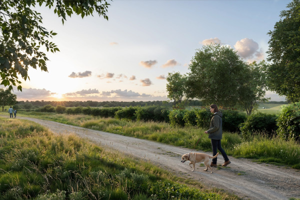
Figure 80: An indicative illustration of the view from the path crossing the railway, looking west. The Bourn tunnel portal can be seen on the right
Hardwick and Toft
Our latest proposals
The railway would emerge from the east end of the A428 Bourn Airfield tunnel into a deep cutting. The Harcamlow Way/Wimpole Way long distance path (Hardwick Bridleway 5) would be diverted onto a bridge over the railway. The bridge is designed to include wide planted sections, which would provide habitat connectivity for protected species between various local habitats. We would provide landscape mitigation, including tree planting, around the green bridge to integrate shallower slopes, screen views of the railway, and provide for wildlife connectivity.
A section of the Highfields Caldecote watercourse, a tributary of Bourn Brook, would be diverted to the east of the railway and incorporate measures to reduce flood risk. Landscape planting would be incorporated to provide habitat and wildlife connectivity to the green bridge.
The railway would then operate at ground level before rising to pass above a watercourse before entering into another cutting. As outlined in our You Said, We Did Autumn Update, the railway would then pass beneath Hardwick Road 200 metres further west than previously proposed. This would reduce the impacts on two watercourses, shortening the length of diversions required. We would provide landscaping in this location to reduce the visual impact of the railway.
Hardwick Road would be realigned onto a road bridge above the railway, just west of Asplins Farm. This bridge would include a planted section to provide habitat connectivity for mammals, including barbastelle bats. It would allow wildlife to move between Hardwick Wood Site of Special Scientific Interest, ancient woodland, and foraging habitat to the east. We would provide landscape mitigation, including tree planting, around the bridge to integrate shallower slopes and screen views of the railway.
The bridge would include a walking and cycling path along the western side of the carriageway. This path would extend south to connect with Toft Footpath 6.
We would provide replacement access roads to Asplins Farm and Frogs Hall that would be shorter than the layouts we previously proposed. Access roads would be provided from Hardwick Road to access the railway for maintenance. To accommodate these changes, Halfway House, part of Asplins Farm, would require demolition.
South of Hardwick Road, the railway would continue across undulating landscape, heading towards Toft and Comberton to the south. The railway would pass above a watercourse, and we would provide landscape mitigation earthworks, including planting, on the east side of the railway to provide screening and integration with the landscape. A drainage attenuation pond and track maintenance access point would be provided to the north of B1046 Comberton Road, with an access route extending south to the road. Two farm buildings close to the B1046 Comberton Road would need to be demolished.
Approach to construction
We propose 11 main construction compounds in this route section, including one at each end of Bourn tunnel to support construction of the tunnel. Each compound would be adjacent to and accessed from the public highway. Connections include Cambridge Road (existing A428), Toseland Road, Saint Ives Road (B1040), Ermine Street South (A1198), St Neots Road, Hardwick Road, and Comberton Road (B1046). Construction traffic would typically use the new A421 dual carriageway, the existing A428 and the M11 to access local roads and these compounds.
Four further satellite compounds would also support the works. These would facilitate earthworks movements and the construction of smaller structures, such as footbridges, minor highway interventions, and access roads.
Our proposed construction compounds have been further developed in response to feedback and ongoing construction planning including:
-
On the east side of B1040 St Ives Road, we’ve removed the previously proposed construction and logistics site to the east of Papley Grove Farm from our plans
-
The construction and logistics site that was previously proposed above the cut and cover tunnel has been removed. Instead, we would use a 60 metres wide area above the tunnel to monitor construction settlement.
-
The fields on the south side of Hardwick Road would no longer be required for construction and logistics compounds, though we would still require a construction and logistics site on the north side of Hardwick Road adjacent to the proposed railway
We would need to complete some 24‑hour and weekend working at certain locations to support the planned tunnelling work at Bourn, as this reduces the risk of tunnel instability and limits ground settlement.
Construction traffic routes are shown on the plans and would vary during the construction period, depending on road closures and associated diversion requirements.
The details and locations of all construction compounds and associated stockpile areas within this section of the route are illustrated in the construction plans which can be found at eastwestrail.co.uk/consultation2026
This is where the Croxton to Toft route section ends. The railway would then transition to the Comberton to Shelford route section.
Comberton to Shelford
East West Rail (EWR) would operate from Comberton to Shelford on this 14.3km (8.9 mile) route section. This route section starts at the B1046 Comberton Road and ends at Addenbrooke’s Road, Shelford. We would build a new two‑track railway along this route as far as Harston. Trains would be powered by on‑board batteries as far as Hauxton Junction, where EWR would join the electrified Shepreth Branch Royston Line.
This chapter presents our updated proposals for the Comberton to Shelford route section.
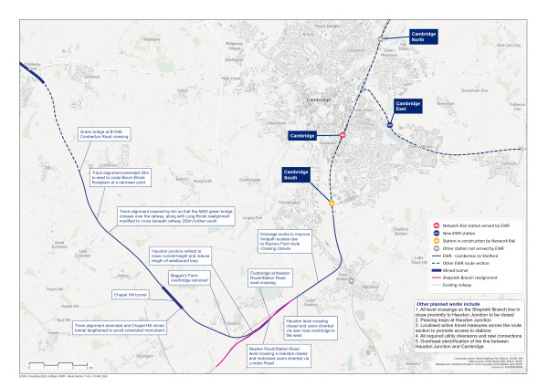
Figure 81: Map of the planned route of the project from Comberton to Shelford
Comberton
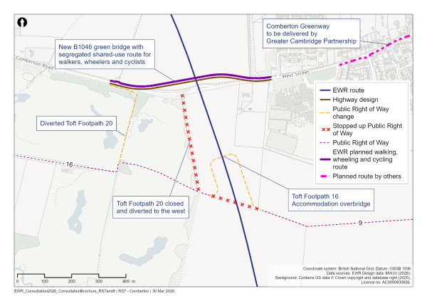
Figure 82: Map of EWR route near Comberton
Our latest proposals
The new two‑track railway would pass under the B1046, which would be realigned north of its current alignment on a new bridge over the railway. Since our previous consultation, we have raised the height of the railway north of Comberton to reduce construction impacts and cross over a water course. This means the height of the bridge would increase by 5 metres, with the railway now 1 metre below existing ground level where it crosses the B1046. By reducing the speed limit across the bridge we have been able to reduce the footprint of the bridge as it crosses over the railway. The bridge would also include planted sections, making it a green bridge. Additional landscaping earthworks are included adjacent to the railway on the north and south side of the bridge to better integrate with the surrounding landscape.
This bridge would incorporate a segregated shared‑use footpath and cycleway, which would connect with existing walking, wheeling and cycling routes. The design of this bridge has been widened to accommodate a 30‑metre‑wide planted section to provide habitat connectivity for wildlife, including small mammals. Landscape mitigation earthworks surrounding the green bridge would integrate shallower slopes, which would be planted with trees to screen views of the railway and provide habitat for wildlife.
The railway would continue south, passing east of the Cambridge Meridian Golf Club. The new footbridge for Toft Footpath 16 would enable the diverted public right of way to cross the railway and would provide an access route for farm vehicles. Landscape earthworks and woodland planting in this area would screen the railway and bridge.
Toft Footpath 20, which runs alongside the eastern edge of the Cambridge Meridian Golf Club, would be moved 250 metres west.
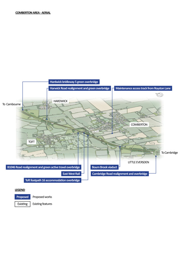
Figure 83: An indicative aerial illustration of the Comberton area
Bourn Brook
Our latest proposals
The compound with telecommunications equipment, which was previously proposed to the west of the railway, has been moved to the east of the railway to avoid increasing the flood risk. This compound would be accessed via a maintenance access track from South Street along Toft Footpath 1. This removes the previously proposed maintenance access tracks parallel to both sides of the railway which extended to the B1046. Landscape planting is proposed at this location on both sides of the railway.
The railway would then rise to an embankment and cross Bourn Brook on a viaduct. As announced in our You Said, We Did Autumn Update, we have altered the alignment of the railway at the crossing of Bourn Brook to minimise environmental impacts. The new crossing would be 30 metres further west of where it was previously proposed, where the flood plain is much narrower. This means we’re able to reduce the length of the viaduct from 250 metres to 155 metres. We have lowered the height of the track and embankment to the north of the Bourn Brook viaduct.
The new viaduct would improve connectivity between river habitats and reduce habitat loss, providing benefits for protected mammal species. Proposed enhancements include creating marsh, lowland meadow, grassland and woodland to link the watercourses, along with a dedicated floodplain compensation area.
The new railway would continue south‑east on an embankment, crossing Great and Little Eversden Footpath 26 and a tributary of Bourn Brook, both of which would go under the railway.
The railway would cross the Cambridge Road (A603). Informed by feedback from our previous consultation, we’ve significantly reduced the height of the railway here to minimise visual impacts and reduce the amount of earthworks required in the area. The railway would now cross under the road instead of over it, with the A603 realigned to the north‑west onto a new bridge.
This bridge would include a 30‑metre‑wide planted section to provide connection to nearby habitats. Landscape mitigation earthworks alongside the green bridge would use shallower slopes which would be planted with trees to screen views of the railway and provide habitat for wildlife.
The railway would pass to the south‑west of the Mullard Radio Astronomy Observatory (MRAO). We will continue to work with the University of Cambridge to assess and understand the electromagnetic compatibility/interference (EMC/EMI) and vibration impacts of the project on the MRAO. We are also conducting studies on other railways to identify lessons and inform our joint working.
Minor diversions of Comberton Road and Washpit Lane would be required to connect to the realigned A603. The demolition of a commercial property would still be required at Washpit Lane to accommodate the railway alignment and we are engaging with the landowner on this.
To support our proposals to reduce embankment heights and realign the A603 above the railway, we would divert the Long Brook watercourse so that it crosses beneath EWR 500 metres south‑east of its current location. This realignment would enhance the local environment and is designed to resemble a natural watercourse. The design maintains the flow of water at the Moated Complex, a scheduled monument, to reduce indirect impacts.
Floodplain compensation areas would be provided adjacent to Long Brook, avoiding nearby buried archaeology that may be associated with the Moated Complex. Woodland and grassland planting around the watercourse and flood compensation would provide habitat and support wildlife connectivity at this location.
Harlton and Haslingfield
Our latest proposals
After crossing Long Brook, the new railway would gradually descend to ground level, before crossing under Harlton Road in a cutting. Harlton Road would be realigned on to a new bridge just to the south of its current location. We’ve lowered the railway here since our previous consultation, which has enabled us to reduce the height of the Harlton Road bridge by over 2 metres. This is subject to further detailed technical work and ground investigations. This new bridge would incorporate a new walking, wheeling and cycling route, extending to the Harlton Road junction with Church Street in Haslingfield and the eastern edge of Harlton village.
Landscaping would provide screening of the rail embankment on both sides of Harlton Road for local residents. The earthworks would also deter bats from crossing the railway here and encourage them to take a safer flightpath.
South of Harlton Road, the railway would enter a tunnel where the land rises steeply at Chapel Hill and Money Hill south of Haslingfield. As outlined in our You Said, We Did Autumn Update, the length of this tunnel has increased since our last consultation, from 700 metres to 940 metres. This has allowed us to reduce the size of cuttings required at each end of the tunnel, also reducing the amount of material that needs to be transported during construction and the cost of construction.
At the north tunnel portal, this increase in length avoids the need to divert existing overhead electricity cables. We have increased the proposed landscape screening earthworks on the east of the tunnel approach.
At the south tunnel portal, we’ve moved the tunnel alignment slightly to the south‑west. This allows the railway to avoid the Bronze Age round barrow cemetery at Money Hill, which has recently been designated as a scheduled monument. Landscaping, including earthworks, at the south tunnel portal have also been included to integrate with the surrounding landscape while avoiding impacts on the scheduled monument.
Tunnel service buildings would be constructed at each end of the tunnel within the cuttings to house operational and maintenance equipment. At the north tunnel portal, the maintenance road would connect to Harlton Road. At the south tunnel portal, we have removed the western track maintenance access point, which allows us to remove the previously proposed maintenance access road from Chapel Hill, following feedback from our previous consultation. The track drainage balancing pond has been moved from the west to the east of the railway and would be accessed from the remaining maintenance access road connecting to Haslingfield Road. This has reduced negative landscape effects in the Chapel Hill area.
We’re continuing to review our proposed design for Chapel Hill tunnel and associated cuttings to take account of the results of ongoing ground investigations.
After the tunnel, the railway would rise onto an embankment as it passes to the south of Penn Farm and Charity Farm.
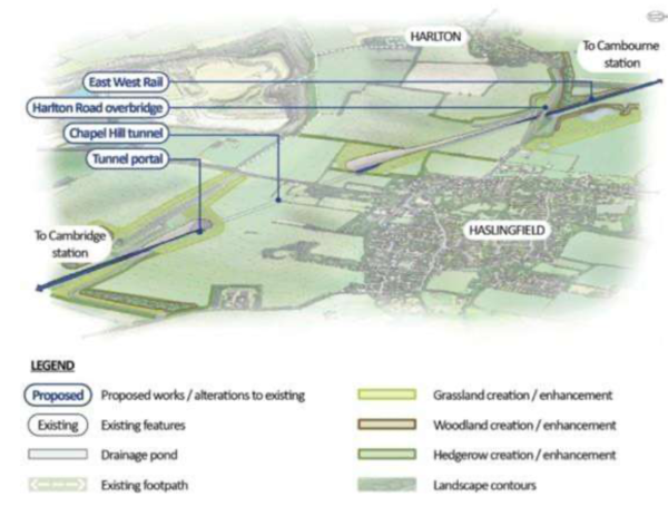
Figure 84: An indicative aerial illustration of Chapel Hill
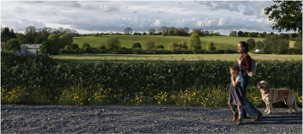
Figure 85: View south towards entrance to Chapel Hill tunnel from new footpath off Harlton Road
Harston, Newton and Hauxton
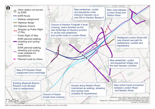
Figure 86: Map of the EWR route around Harston, Newton and Hauxton
Our latest proposals
The railway would then cross the River Rhee on a viaduct, passing south of Harston Mill. The viaduct’s design has been updated to maintain clearance for bat flightpaths along the River Rhee and River Cam, and to retain the existing public right of way. Further planting would form part of the mitigation strategy to support habitats around the River Rhee and River Cam.
The railway would then return to ground level and pass under the A10 Royston Road, which would be diverted onto a new bridge. Following engagement with landowners, we’ve removed the proposed Baggot Hall Farm accommodation bridge from our design to reduce visual impact and land needed. This has allowed us to realign the maintenance access road.
The route would then continue around the southern edge of Harston, converging with the Shepreth Branch Royston Line (SBRL) at the proposed new Hauxton junction. The eastbound and westbound EWR tracks would diverge west of Station Road and Newton Road, Harston, before rejoining the SBRL east of London Road and Cambridge Road.
Previously, both SBRL tracks were diverted over the EWR westbound tracks. Our design has been updated so that only the eastbound SBRL track would cross over the westbound EWR tracks, while the SBRL westbound track would be diverted further south around the outside of the junction. This alignment better follows the natural topography of the area, helping to reduce visual impacts. This change has enabled a reduction in the height of the grade‑separated junction by 2.7 metres, meaning this section of the rail line would now sit around 7.5 metres above ground level instead of 10.2 metres. As a result, only one railway line would need to be elevated above the ground‑level tracks. By reducing the height of the railway, we would also decrease the width of the embankment. This would reduce the amount of material required to be transported to the site, resulting in fewer lorry movements on local roads. The new railway would then continue on existing tracks beneath the M11.
The Newton Road/Station Road level crossing in Harston would be closed. At our previous consultation, we presented two options to maintain the connection between Harston and Newton. As we outlined in our You Said, We Did Autumn Update, we have decided to proceed with Option 4. This option would create a new road between London Road and Station Road along the alignment of the existing railway. Access along Newton Road would be maintained, allowing pedestrians, cyclists and equestrians to travel along Newton Road to access the proposed footbridge. This new road would include a route for pedestrians and cyclists to join London Road and travel south towards Newton, with the current route along Cambridge Road towards Newton village also upgraded. The existing railway would continue to be used east of London Road, with a new pedestrian, cyclist and equestrian route linking to Hauxton via a new link to Harston Byway 6, as well as the Shelfords and beyond. Landscape mitigation earthworks, including planting, are proposed on all the new road connections and would screen the highways for nearby residents.
In our You Said, We Did Autumn Update, we confirmed that a bridge for pedestrians, cyclists and equestrians would be provided over the new Hauxton junction, maintaining connectivity on the Station Road and Newton Road alignment between Newton and Harston.
We have reviewed the design of this bridge to see if there were any improvements that could be made. We confirm that we have retained the solution presented at the 2024 consultation as the best performing option.
We note that the height of this structure would need to be around 10 metres to pass over the junction and, given the width of the junction, the length of the bridge plus connecting ramps would need to be 135 metres.
In response to feedback, if this bridge is constructed, we’re proposing a further pedestrian, cyclist and equestrian connection back to London Road on the southern side of the new footbridge. The drainage design has also been modified to include planting that would allow better screening of the footbridge, railway and embankments.
London Road would be realigned, slightly to the west. The design has been updated since our last consultation, with the underpass structure connecting to Shelford Road being replaced with a junction arrangement. This has reduced the length of new road and earthworks required. The bridge over the railway would be replaced and landscaping would be provided to screen the new road. An active travel route would be provided along the length of London Road connecting Newton village to the new road that connects to Station Road, to Donkey Lane, and to our proposed new active travel route that connects through the villages to Great Shelford, the DNA Path and Cambridge South station. We also propose a new connection from London Road onto the new active travel bridge. This would provide a new active travel connection from London Road to Newton Road. A flood compensation area would be provided south of the new junction. Further flood compensation areas would be provided either side of the watercourse between Donkey Lane and Shelford Road.
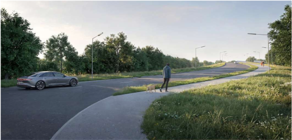
Figure 87: An indicative illustration of the view from the A10 Royston Road, looking southbound towards the bridge over the railway line
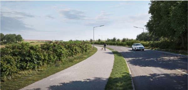
Figure 88: An indicative illustration of the view from Station Road, looking east along the new link road
The construction and operation of the new Hauxton junction would require the closure of two level crossings in this area:
-
Hayes level crossing, 1km (0.6 miles) west of Harston. This private crossing is currently used for farm access.
-
Harston Footpath 4 level crossing (previously referred to as level crossing No.37), between Newton Road and London Road. Users would be diverted to cross the railway via the new footbridge at Hauxton junction or via the new pedestrian and cyclist route along the realigned London Road.
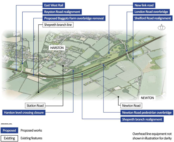
Figure 89: An indicative aerial illustration of the preferred connectivity solution between Newton and Harston
Two passing loops would be constructed in this area to allow faster services to pass slower moving trains. The westbound passing loop would be west of the A10 Royston Road, extending further west to the Chapel Hill Tunnel portal. We’ve shortened this passing loop from 4,000 metres to 1,375 metres since our previous consultation, which moves it further away from Harston. The eastbound passing loop would be located between Station Road and Newton Road and the M11.
The Shelfords
Our latest proposals
Having passed beneath the M11, the EWR route would continue along the existing two‑track SBRL railway, passing through Little Shelford. The Hauxton Road level crossing would be closed and a new road bridge over the railway would be provided west of Little Shelford, linking High Street with Newton Road. Pedestrians, cyclists and other users of the existing crossing would also be able to use this road bridge. Landscape mitigation earthworks, including planting, would provide screening for residents. Additional planting would be provided in areas where new rail infrastructure such as compounds are located. Noise barriers would be installed alongside sections of the railway on both sides where it crosses Hauxton Road.
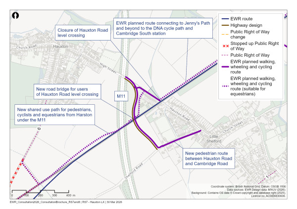
Figure 90: Map of Hauxton Road level crossing
At the previous consultation, we asked for feedback on whether an extra footbridge should be provided east of the existing level crossing to supplement the new bridge to the west. Taking account of feedback and local engagement, we have decided not to provide this here due to its visual impact on local properties, as well as the cost and construction impacts. Additionally, overall travel distances and times would not be improved for the majority of users travelling between Hauxton and Little Shelford due to the length of ramped structure needed to cross the railway.
To maintain local connectivity, we propose to build a new route for pedestrians and cyclists along the north of the railway between Hauxton Road and Cambridge Road at Great Shelford. This would provide a safe and dedicated active travel route for communities.
Our proposals include a new pedestrian link from Harston through to Little Shelford, connecting to Jenny’s Path and providing further onward connections towards the DNA cycle path and Cambridge South station. These proposals would pass through the scheduled monument to the west of the West Anglia Main Line. We’re continuing to work with stakeholders in developing these plans.
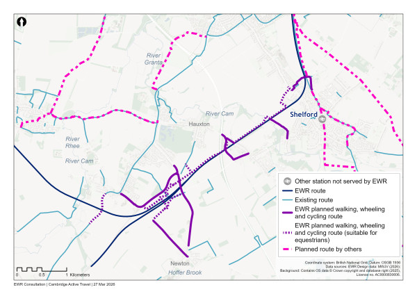
Figure 91: Map of planned active travel measures south of Cambridge
The EWR route would then continue along the existing SBRL towards Great Shelford, crossing the River Cam. The Rectory Farm level crossing, just to the north of the River Cam, would be closed. Following feedback from our previous consultation, we have included measures to improve drainage at the adjacent Jenny’s Path underpass to reduce the risk of flooding.
Shepreth Junction and the West Anglia Main Line
Our latest proposals
The EWR route would continue along the SBRL corridor, passing beneath Cambridge Road at Great Shelford. It would then connect into the West Anglia Main Line (WAML) at the existing Shepreth Junction, to the north of Great Shelford. Noise barriers would be installed alongside sections of the railway on both sides of the curve approaching Shepreth Junction to reduce noise impacts.
The existing two‑track WAML cannot accommodate the additional EWR services. We would need to widen the railway from two tracks to four tracks, from Shepreth Junction northwards, through to Cambridge station. Two new EWR tracks and associated infrastructure would be built to the west of the WAML between Great Shelford and Cambridge South station. The existing Shepreth Junction would be remodelled to accommodate the widened tracks. Landscape planting, including grassland, and hedgerows would be provided east of the WAML to screen it from residents. We would retain existing trees wherever possible.
The footbridge which currently carries Great Shelford Footpath 1 over the railway would be replaced with a ramped footbridge to cross over the widened railway. We are considering the best location for this footbridge to improve connectivity across the railway and access to open spaces, including Ninewells Local Nature Reserve.
Our proposals have been developed to limit the amount of land required on the west side of the railway, reducing impacts on the scheduled monument in this area. The land designated as a scheduled monument would be taken out of agricultural use to better preserve the buried archaeology and offer opportunities for increasing public open space and connectivity. Landscape planting, including grassland, hedgerows and trees, would be provided on both sides of the tracks to screen the railway. The route continues north and would cross the Hobson’s Conduit on a bridge south of Addenbrooke’s Road. This bridge would be widened to accommodate the additional tracks. The EWR route then passes beneath the existing Addenbrooke’s Road bridge, where this route section ends. Replacement landscape planting including grassland and trees would be provided to the west of the railway, south of Addenbrooke’s Road.
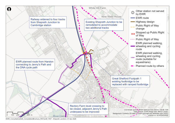
Figure 92: Map of Shepreth Junction
Approach to construction
We propose seven main construction compounds in this route section, including one at each end of Chapel Hill tunnel to support construction of the tunnel. Each compound would be accessed from the public highway. Connections include Cambridge Road (A603), Harlton Road, Royston Road (A10), London Road (B1368), Granham’s Road, and Addenbrooke’s Road. Construction traffic would typically use M11 junctions 11 and 12 to access local roads and these compounds.
Four further satellite compounds would support the works. These compounds are proposed at Barrington Quarry (to support earthwork movements), by London Road to support the realignment of the existing SBR line, and east of the M11 to support the new Hauxton Road realignment and bridge.
Since our previous consultation, we have further developed our proposals for our construction compounds and working areas. This includes:
-
Taking account of landowner feedback and reduced earthworks due to shallower cuttings, we have moved the construction site to the south of Comberton village from the east of the railway to a smaller land parcel on the west of the railway, adjacent to the golf course
-
A proposed conveyor system between the Chapel Hill Tunnel northern portal and Barrington Quarry would be used to remove soil and waste arising from tunnelling that cannot be reused elsewhere on EWR
-
The construction compound proposed to the south of the MRAO site (east of the railway) has now been removed from the design
-
We have removed the previously proposed construction compound on the western fringe of Haslingfield near Wells Close and moved this to the north of Harlton Road, following the feedback from the previous consultation
-
Reducing the size of the Addenbrooke’s Road compound to reduce the impact on the proposed open space creation being provided by Network Rail as part of the Cambridge South station
We would need to complete some 24‑hour night‑time and weekend working at certain locations. This includes works on or adjacent to the existing railway, and works to support the planned tunnelling work at Chapel Hill, as this reduces the risk of tunnel instability and limits ground settlement.
The details and locations of all construction compounds and associated stockpile areas within this section of the route are illustrated in the accompanying construction plans.
Construction traffic routes are shown on the plans and would vary during the construction period, depending on road closures and associated diversion requirements.
This is where the Comberton to Shelford route section ends. The railway would then transition to the Cambridge route section.
Cambridge
East West Rail (EWR) would operate through Cambridge on this 8km (5 mile) route section. This starts at Addenbrooke’s Road, Shelford and ends at the A14 north of Cambridge. The route would operate alongside the existing West Anglia Main Line which would be fully electrified, with Newmarket Line electrification subject to future strategy.
The route section also extends 5km (3 miles) along the existing Newmarket Line between Coldhams Lane in Cambridge and Wilbraham Road, Fulbourn, to the east. Our proposals include the construction of a new Cambridge East station, improvements to Cambridge station (including a new eastern entrance at Clifton Road). Further east near Fulbourn, we’re exploring the possibility for a new Cambridge Eastern train care centre to support the operation and maintenance of railway services on the Newmarket Line and the wider route. Fulbourn has been identified as a possible location for this facility, but we are also continuing to work with other train operators in the Cambridge area to explore whether an alternative location might offer better opportunities to reduce construction impacts and improve service reliability when EWR opens.
This chapter presents our updated proposals for the Cambridge route section. We are seeking your views in particular on our proposals for:
-
The new eastern entrance for Cambridge station
-
Cambridge East station
-
The Cambridge Eastern train care centre
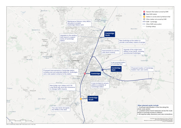
Figure 93: Map of the planned route of the project in Cambridge
Addenbrooke’s Road to Cambridge station
Our latest proposals
The upgrade of the existing railway to four tracks would continue north from Addenbrooke’s Road to Cambridge station. The majority of the land that would be required is already owned by Network Rail.
At the new Cambridge South station, currently being built by Network Rail, we would tie‑in with the existing four‑track configuration. No alterations are proposed at Cambridge South.
North of Cambridge South station, the new tracks would pass beneath the existing Cambridgeshire Guided Busway bridge. Busway operations would be unaffected by our works.
Long Road bridge
At Long Road the existing A1134 bridge would be replaced with a wider bridge to accommodate the extra tracks. We have tested multiple options for how best to replace this bridge and add the new tracks beneath, given that Long Road is a key route within Cambridge and the West Anglia Main Line is a busy rail corridor. We have taken the decision to fully close the road to rebuild the bridge for a period of six to thirteen weeks. We would use techniques such as off‑site pre‑fabrication to reduce disruption during the works. In addition, we’re developing a wider plan for the local area, including scheduling the works during school holidays when traffic is lower, working with the local authority to understand and coordinate other planned works in the area, and working with emergency services to ensure continuity of operations.
The additional span of the bridge and construction works would impact priority habitat and protected trees around Long Road. Where possible, this would be protected. Where this is not possible, we would provide new landscape planting.
To provide drainage for the upgraded railway, a drainage pond is proposed within Darien Meadow. We recognise that Darien Meadow is an important recreational space, and grassland affected within the meadow would be reinstated around the proposed drainage pond.
North of Long Road, the upgrades would pass beneath the A1307 Hills Road. No changes are proposed to Hills Road bridge. Noise mitigation measures, likely a noise barrier, would be installed along both sides of the railway on the approach to Cambridge station.
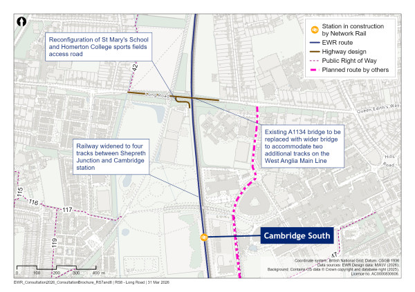
Figure 94: Map of Long Road bridge and associated works
Approach to construction
Construction of the proposed rail corridor to support the twin‑track installation from Addenbrooke’s Road to Cambridge station would be enabled by several construction compounds.
These would include compounds to the south‑west of Long Road, within the sports fields of St Mary’s School, and on both sides of the railway at Cambridge station. A further compound would be placed in the sports ground next to Long Road and Sedley Taylor Road. The rugby pitches would be temporarily moved to an alternative location while we are working. The compound would support the construction of the new bridge and the associated realignment of Long Road. The compound would be accessed from Long Road via a new entrance which would remain following construction and provide a new permanent entrance to the sports fields to the east of the railway.
Three small satellite compounds would be needed along this section of the route. The first would be to the north of Long Road, next to the existing guided busway, for the construction of Long Road bridge. The second would be on Purbeck Road, and would provide a temporary access route for workers to access the existing railway. The third would be to the south‑west of Cambridge station, just off Station Place, and would also enable access to the railway.
Access to the compounds would be provided directly from nearby roads. Construction traffic would use a number of routes, including the M11 via Hauxton Road, High Street, Trumpington and Long Road, the A11 via Babraham Road and Hills Road (A1307), and the A14 via Mowbray Road and Perne Road (A1134).
Cambridge station
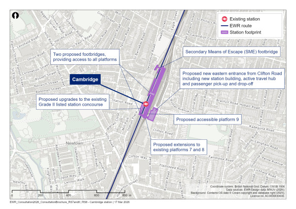
Figure 95: Map of Cambridge station
What we presented at our previous consultation
We proposed changes to Cambridge station to improve capacity and accessibility, and to support the increased train services and passenger numbers that EWR would bring. Our proposals were to:
-
Extend the existing platforms 7 and 8
-
Build a new accessible platform 9
-
Build two new footbridges
-
Create new staff facilities for EWR
-
Upgrade the station concourse and add new rail infrastructure (track, signalling, and other rail systems)
What you told us
Many of you were supportive of the proposed changes to Cambridge station as a way of meeting the need for increased capacity, improved accessibility, and improved facilities. Respondents also made suggestions for an eastern entrance on Clifton Road to connect the station with the Coleridge neighbourhood.
During previous consultations, you told us that Cambridge station can feel congested at busy times and that access options are limited, particularly for people approaching the station from the east. You highlighted the importance of step‑free access, easier passenger movements, and better connections for people walking, wheeling and cycling.
You told us that any changes to the station should be carefully designed to respect its historic setting and surrounding neighbourhoods, and that construction impacts should be clearly explained and, where possible, reduced.
Our latest proposals
To support the arrival of EWR services and growing passenger numbers, we need to increase capacity and improve access at Cambridge station. These changes would help improve train service reliability by creating more platform space, reducing congestion, and making it easier for people to move around the station, especially at peak times.
As recently announced, we propose to add a new station entrance on Clifton Road, realising the long‑held ambition to provide an eastern gateway to the station. This would allow a transformational change in how communities access Cambridge station. The new entrance would make the railway more convenient to access and more attractive for residents and local businesses.
The new railway would bring a significant increase in passenger numbers at Cambridge station. The addition of the new eastern entrance would mean some of this increased demand enters and exits the station from the east side. The inclusion of the eastern entrance therefore means that the amount of upgrade infrastructure works on the west side would be less, with less impact on the Grade II listed building than without the eastern entrance.
The entrance would be fully accessible, providing step‑free access to all platforms. It would also have a new active travel hub with bike storage. Existing bus services, taxi rank, and station car parking would remain on the western side. This new entrance would provide a direct, convenient route for people approaching from the east of the city.
The combination of more frequent rail services and active travel connections to the station would be a step‑change in sustainable, clean, and efficient mobility across the city. This would make it easier for people to access all parts of Cambridge as well other destinations on the EWR route.
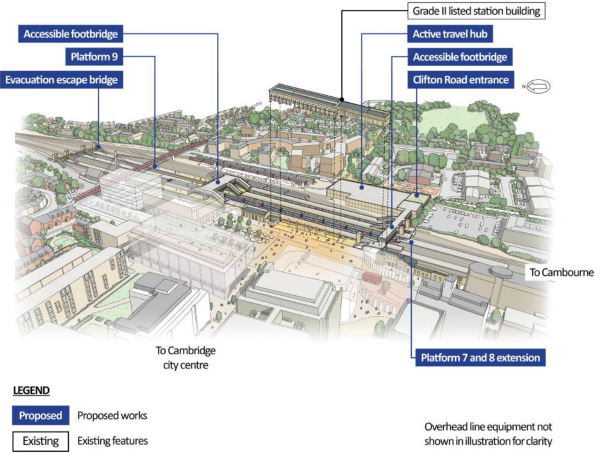
Figure 96: Indicative aerial illustration of Cambridge station
Clifton Road (new eastern entrance)
EWR would provide a new entrance on the eastern side of the station on Clifton Road. This would include:
-
A new station entrance with step‑free access to all platforms, a ticket gateline, and staff facilities
-
A small passenger pick up and drop off area outside the station entrance, including spaces for people with reduced mobility
-
An active travel hub outside the station entrance, connected directly to cycle lanes and footpaths, providing secure storage space for hundreds of bicycles, cargo‑bikes, and other small vehicles that help to cut congestion and reduce emissions
-
Landscaping and street improvements around the station entrance, such as seating and lighting, to improve the environment and to better integrate the station with surrounding neighbourhoods
To provide these improvements, we would move the existing Network Rail maintenance facility to a new site west of Cambridge North station. This location gives the team better access to the areas they look after. We’re also exploring how bringing existing and new maintenance functions together could make this service more efficient.
Some of the land needed for the new eastern entrance sits outside the current railway boundary, including commercial property on the Clifton Road industrial estate. As part of this, seven commercial properties on Clifton Road would need to be acquired to make space for the new station entrance and the improved access it would bring. We’re working with owners and occupiers to understand their needs.
We’re looking at how the new entrance could connect with local public transport and active travel routes. This includes exploring links with the future stages of the Chisholm Trail, a walking and cycling route designed to join Cambridge and Cambridge North stations, better connecting the communities in between.
We’ll continue working closely with local authorities, landowners and other partners to ensure the new entrance integrates smoothly with buses, walking and wheeling routes, and other local transport services. This would help people make seamless, sustainable journeys from door‑to‑door.
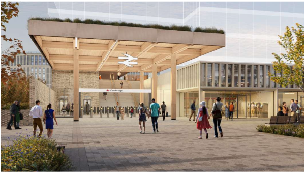
Figure 97: Indicative illustration of Cambridge station eastern entrance
Approach to construction
For the works at Cambridge station, we would use two main construction compounds and one satellite compound.
The main works for Cambridge station would be managed from the main compound to the east. This would be built to the north of the existing Royal Mail facility and adjacent to Clifton Road.
The other main compound to the west would be within the northern station car park to support works to the eastern entrance and track layout modifications. The satellite compound would be to the south‑west of Cambridge station, just off Station Place, and would facilitate access to the existing railway.
Access to the compounds would be provided directly from adjacent roads. Construction traffic would be routed to use roads including the M11 via Addenbrooke’s Road, Long Road, the A11 via Babraham Road, Cambridge Road (A603) and Hills Road (A1307), and the A14 via Mowbray Road and Perne Road (A1134).
We presented these proposals as part of Design Update Sessions in February this year. Feedback received at these events and in response to this consultation will help us refine our plans.
Share your feedback
As part of this consultation, we would like to hear your feedback on our proposals for a new eastern entrance at Cambridge station. We’re particularly interested in your views on:
-
Opportunities we should consider as we develop plans for the entrance, including proposals for walking, wheeling and cycling routes
-
Any facilities or design considerations we should take into account
You can complete our online feedback form or find details of how to respond to our consultation in the How to respond to this consultation chapter.
Newmarket Line east of Cambridge
Our latest proposals
Along the Newmarket Line east of Cambridge, we’re proposing a series of coordinated improvements to support additional rail services and improve connectivity in the area. These proposals include twin‑tracking, with an additional track installed within the existing rail corridor from Coldhams Lane Junction eastwards to the turnback location, just to the west of Cherry Hinton High Street level crossing. As with other sections of the route, we are planning to introduce electrification along the Newmarket Line to Fulbourn.
The existing Coldhams Common footbridge would be reconstructed to become wider, enabling us to extend the railway here to two tracks. Coldhams Common is designated as both Common Land and a Local Nature Reserve, and the design of the replacement footbridge has been optimised to reduce land take within the Common. Landscape planting is proposed on the railway embankments to mitigate visual impacts from the upgraded infrastructure, and any habitats temporarily affected during construction would be replaced.
We’re proposing to construct a new station at Cambridge East, along the existing Newmarket Line to improve access to rail services for communities and planned development in the east of the city. Walking, wheeling and cycling connections in the area would be enhanced, including a connection to the Tins path footbridge, helping to link the new station with existing active travel routes and nearby neighbourhoods.
To the east of the new station, a turnback facility would be added at Cherry Hinton to allow trains to change direction, supporting more frequent and reliable services on the route.
Further east near Fulbourn, there will be a new Cambridge Eastern train care centre to support the operation and maintenance of railway services on the Newmarket Line and the wider route.
Cambridge East station
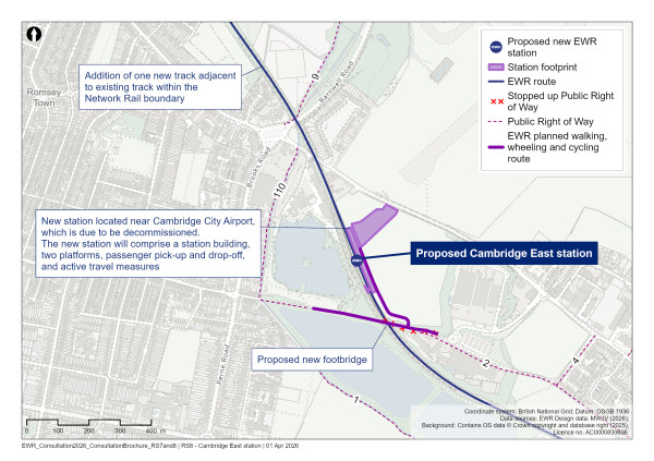
Figure 98: Map of Cambridge East station
What you told us
At our previous consultation many of you suggested a new station east of Cambridge. You highlighted likely such as improved rail connectivity, reduced road congestion, relieved pressure on Cambridge station, and better access to public transport for nearby residents.
You expressed strong support for the role this new station would play in serving new and planned housing developments linked to the Cambridge City Airport redevelopment. You also emphasised its potential to unlock economic growth and create jobs at major employment hubs, including Arm Campus and Peterhouse Technology Park. Many of you recommended connecting the station to walking, wheeling, and cycling routes such as the Chisholm Trail.
Our latest proposals
Our proposed new station, Cambridge East, would improve connectivity and unlock economic growth in the east of the city. This station would be near Cambridge City Airport and along the existing Newmarket Line, which would be upgraded as part of our wider proposals. This station would serve the villages to the east of Cambridge, as well as planned developments in the area, while reducing pressure on Cambridge station. The provision of Cambridge East station would be subject to third party funding.
The station would be near Cambridge City Airport, which is due to be decommissioned, in an area with strong potential for growth and development. Cambridge East would help stimulate economic growth in the area and would unlock a new connection to the wider region through an upgrade to the Newmarket Line, which would in turn enable connections to existing regional links to Felixstowe and Ipswich.
We’ll provide accessibility with step‑free platforms, clear routes through the station, and passenger pick up and drop off, along with blue‑badge parking. We’ll have clear routes through the station, while connections to walking, wheeling and cycling routes would link to existing and proposed active travel corridors such as the Tins path and Phase 2 of the Fulbourn Greenway. Our proposals would also include passenger facilities.
We are in the process of developing the preferred station configuration including station building and facilities. The proposed Cambridge East station location is on a historic landfill site. Our intention is to put Cambridge East station building directly adjacent to the rail line. Due to uncertain ground conditions, we may need to adjust the location of the station or the design layout. The land we set aside for the station may be more than we end up using once completed. We’ll look to reduce the amount of land we need to use where possible.
If the station building is on land further to the north of the Newmarket Line, this could require realignment of Coldhams Lane, which would be subject to further design development and consultation. Any changes would be designed to reduce impacts on road users and the surrounding area, and further details would be developed as the station design is refined.
We’re investigating active travel routes to connect Cambridge East to homes, key destinations, and existing walking, wheeling and cycling routes, including the Tins path. This would contribute to a sustainable integrated public transport network in the area. We would also connect rail and bus services at Cambridge East.
The inclusion of the Cambridge East follows a review of feedback from our previous consultation and ongoing discussions with a range of stakeholders including local authorities, Network Rail, and other third‑party organisations. The provision of this station would be subject to third party funding.
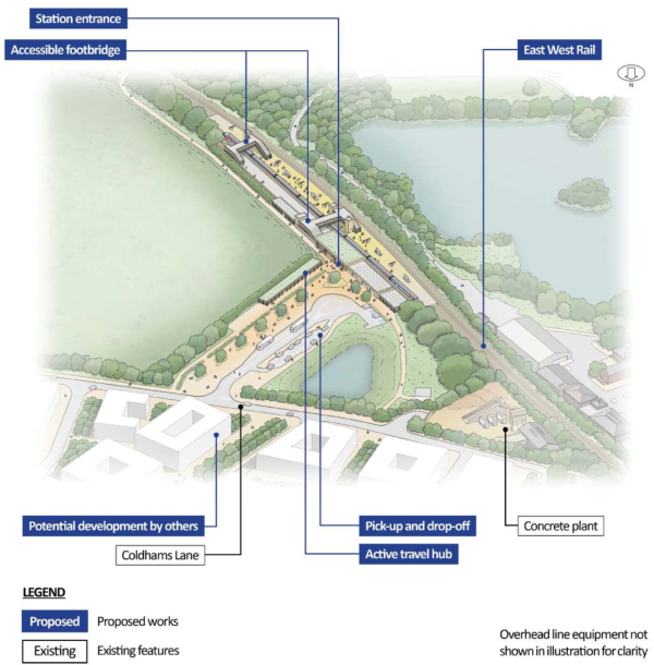
Figure 99: Indicative aerial illustration of Cambridge East station
Approach to construction
To support construction to the east of Cambridge, including the new station and twin tracking of the Newmarket Line, a main construction compound would be built off Coldhams Lane, adjacent to the existing Heidelberg Materials concrete plant.
To replace Coldhams Common footbridge, we would work from a satellite compound within the Common area, accessed from Coldhams Lane. Other works would be supported by satellite compounds, one off Coldhams Road and one near the Holiday Inn off Norman Way and The Tins.
Construction traffic for all of these compounds would be routed to the A14 via Coldhams Lane, Barnwell Road (A1134) and Newmarket Road (A1303).
Share your feedback
As part of this consultation, we would like to hear your feedback on our proposals for Cambridge East station.
You can complete our online feedback form or find details of other ways to respond to our consultation in the How to respond to this consultation chapter.
Cambridge Eastern train care centre
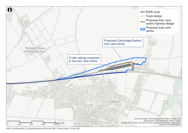
Figure 100: Map of Cambridge Eastern train care centre
What we presented at our previous consultation
At our previous consultation we explained we would need depots to stable and maintain trains while they are not in service. This would include a train maintenance depot and one or more smaller train care centres. A train maintenance depot is the main place where trains are parked and fully serviced. Our proposals for a train maintenance depot are described in Chapter 12). Train care centres (sometimes referred to as light maintenance depots or LMDs) are smaller sites where trains can be cleaned, serviced and kept overnight. We identified broad search areas we were considering for the location of the train care centre.
Our latest proposals
With the preferred location of the train maintenance depot near Bletchley towards the western end of the EWR route, a smaller train care centre is required towards the eastern end to reduce empty train mileage outside normal train service operating hours.
A train care centre would be required to support the day‑to‑day operation of EWR services, including train stabling, cleaning, and routine preparation. We do not expect the train care centre to undertake heavier maintenance activities. Providing these facilities close to where services operate helps to improve reliability and reduces the need for empty train journeys. We have identified Fulbourn as a potential location for the Cambridge Eastern train care centre. However, we are also continuing to work with other train operators in the Cambridge area to explore whether an alternative location might offer better opportunities to reduce construction impacts and improve service reliability when EWR opens. We will carry out further engagement with local communities on the proposed location of the train care centre later in 2026.
The proposed train care centre would include:
-
Six stabling tracks (the number may be subject to change dependent on the train timetable)
-
Facilities for train cleaning, toilet emptying, replenishment of screen wash and sand
-
Staff welfare facilities
-
Walkways with directional lighting
-
Road access and car parking
The layout of the site has been developed to make efficient use of land while supporting the safe and effective operation of the depot. Further refinement of access arrangements will be shaped by ongoing design development and feedback received during this consultation.
Our options assessment considered the question of what infrastructure EWR would need to deliver suitable maintenance facilities without relying on facilities used by other operators. This is necessary to make sure the railway can function on a standalone basis. However, with the creation of Great British Railways there are more opportunities to collaborate with regional train operators to explore alternative solutions. This could include constructing a facility in an alternative location as well as making use of existing train care facilities.
We are exploring whether alternative solutions might reduce construction impacts on other regional services and enable better, more reliable services when EWR opens. If our ongoing collaboration with the wider rail industry produces a better solution, we will carry out further engagement on updated proposals for the train care centre later in 2026. A detailed options assessment for an EWR‑only solution was carried out to identify the preferred site for the train care centre.
The process started with the identification of 52 potential sites for the location of the train care centre either along or near the route, including the consideration of the expansion or reuse of existing depot sites. A generic depot layout was used to determine the feasibility of these sites. The assessment considered the following:
• Whether the site would be large enough to accommodate a train care centre and could be practically connected to the nearby railway
• Whether the location was suitable to reduce empty train mileage from key stations along EWR
• If the site would be likely to have direct impacts on sensitive designated environmental features
• If the surrounding road network was suitable for site access Whether the site was located in Development Plan allocations or could impact existing or emerging planning applications
This assessment resulted in two potential locations for the train care centre, one near Foxton and one near Fulbourn, for which we developed concept layouts to carry out a more detailed assessment to select the preferred location.
Having carefully reviewed both sites, we selected Fulbourn as the most likely location for the train care centre, considering EWR needs alone. Fulbourn has suitable space and connects to the railway to provide the facilities necessary for passenger services. Its closeness to the EWR route limits long movements of empty trains at the start and end of service, improving reliability and reducing potential impact for existing services.
A technical report describing the option section process is available on the EWR website at eastwestrail.co.uk/consultation 2026
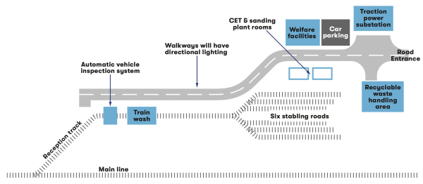
Figure 101: A diagrammatic layout of Cambridge Eastern train care centre
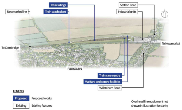
Figure 102: An indicative aerial illustration of Cambridge Eastern train care centre
We are currently assessing the impacts of our proposals for the existing level crossings along the Newmarket Line. These are:
-
Cherry Hinton High Street level crossing
-
Cherry Hinton bypass level crossing
-
Teversham automatic level crossing
-
Cox’s Drive private pedestrian access
We are assessing what interventions may be required at these crossings, taking into account future train service patterns, safety requirements, and operational performance.
No decisions have yet been made, and we are continuing to collaborate with regional train operators to explore alternative solutions that might reduce construction impacts and provide better, more reliable services when EWR opens. If our ongoing collaboration with the wider rail industry produces a better solution, we will carry out further engagement with relevant stakeholders and local communities later in 2026.
Approach to construction
If confirmed as the preferred solution, the proposed train care centre and the associated track works on the Newmarket Line near Fulbourn would be managed from a single construction compound. This would be just north of the Fielding industrial estate and would be accessed from Wilbraham Road. Construction traffic for these works would likely be routed to the A11 via Wilbraham Road and Mill Road, but this remains to be confirmed.
Share your feedback
As part of this consultation, we would like to hear your feedback on our proposals for Cambridge Eastern train care centre.
You can complete our online feedback form or find details of how to respond to our consultation in the How to respond to this consultation chapter.
North of Cambridge station
Our latest proposals
North of Cambridge station the EWR route would continue along the existing railway corridor, passing beneath Mill Road, Coldhams Lane and the A1134 Newmarket Road, before crossing the River Cam on the existing viaduct to approach Cambridge North station.
The design in this area includes updates to the track layout and infrastructure to support EWR while improving operational capability to the north. We do not intend to introduce additional rail services to Cambridge North station. Noise mitigation would be provided between Mill Road and Coldhams Lane.
At Cambridge North, the track layout would be modified to support the wider operational strategy for the Cambridge area and reduce construction impacts when we build the main scheme. These changes would enable the re‑provision of railway sidings removed elsewhere as part of the station works at Cambridge, and provide flexibility for EWR services to terminate at Cambridge North station if needed. We are considering a new footbridge north of the station to provide a secondary emergency evacuation route.
A new Maintenance Delivery Unit (MDU) is proposed on the west side of the railway 350 metres north of Cambridge North. This MDU would provide a home for maintenance teams to enable efficient responses to maintenance incidents on the railway. The unit would comprise staff welfare facilities, equipment and materials storage and parking for staff maintenance vehicles.
Proposals also include updates to rail access and supporting infrastructure north of Cambridge North, including changes to traction power and telecommunications assets, to enable the safe and reliable operation of services.
The updates to Cambridge North and the MDU are currently not expected to have any significant impact on the existing pedestrian, cycle and highway access to the station.
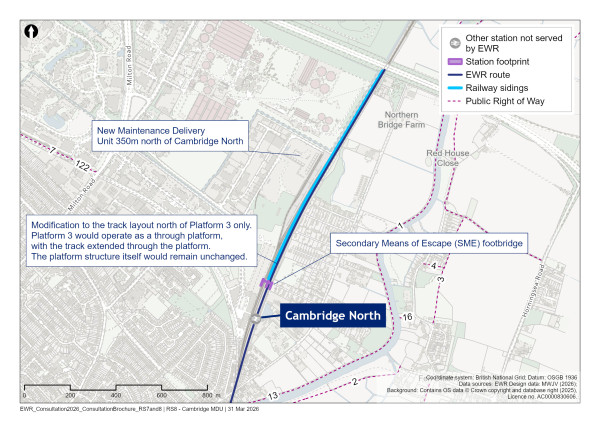
Figure 103: Map of Maintenance Delivery Unit north of Cambridge North station
Approach to construction
To undertake the work at Cambridge North, a main construction compound would be established within the existing car park at the junction of Milton Avenue and Cowley Road. Construction traffic for this would be routed to the A14 via Cowley Road and Milton Road.
A further construction compound would be built to the east of the railway, immediately south of the A14. This would support construction of the new traction power compound and the associated modifications to the existing track infrastructure at Cambridge North. Construction traffic for this would be routed to the A14 via Fen Road, Water Street, Green End Road and Milton Road.
This is the eastern end of the EWR route.
List of consultation materials
We’ve produced the following consultation materials, available at eastwestrail.co.uk/consultation 2026, to give you the information you need to respond to this consultation, including:
-
This document, the consultation brochure, providing details of our updated proposals and the benefits the railway would bring. It also explains how you can provide your feedback.
-
Route maps illustrating the proposed alignment of the railway and its relationship to existing settlements, transport networks, and environmental features
-
Interactive map allowing users to explore the proposals online, view location‑specific information, and understand how different elements of the project relate to their local area
-
Flythroughs illustrating parts of the route
-
Plans showing the proposed railway, providing more detailed information about the alignment EWR would take and associated infrastructure along the route
-
Active Travel maps and construction route maps
-
A feedback form, available in both printed and online versions, which you can use to submit feedback
-
Factsheets setting out further information on specific topics, such as our approach to freight, construction, and environmental considerations
-
Frequently Asked Questions (FAQs), providing clear answers to common questions about the proposals, the consultation process, and what EWR could mean for local communities
Our consultation events
We are holding a series of consultation events across the route. At each event, you can see how our proposals have evolved, talk with members of our team, ask questions and submit your feedback.
In‑person events will take place between 14:00 and 19:00 on weekdays and between 12:00 and 17:00 on weekends at the locations below, with the exception of our Stewartby event which will run to weekend times.
Table 2: Consultation event locations and dates
|
Event location |
Date |
|
Online event, 18:30-20:00 |
Monday 20 April |
|
Stuart Memorial Hall, Church Street, Tempsford, SG19 2AW |
Thursday 23 April |
|
Summerlin Community Centre, 138 Station Road, Woburn Sands, MK17 8SG |
Saturday 25 April |
|
Bletchley Masonic Centre, 263 Queensway, Fenny Stratford, Bletchley, MK2 2BZ |
Wednesday 29 April |
|
Stewartby Village Hall, Stewartby Way, Stewartby, MK43 9LU |
Thursday 30 April |
|
Shelford Rugby Club, The Davey Field, Cambridge Road, Great Shelford, CB22 5JJ |
Friday 1 May |
|
Online event, 15:00-16:30 |
Wednesday 6 May |
|
The Kings Centre, Osney Mead, Oxford, OX2 0ES |
Tuesday 12 May |
|
Lidlington Village Hall, High Street, Lidlington, MK43 0RN |
Thursday 14 May |
|
Longueville Hall, Whaddon Road, Newton Longville, MK17 0AT |
Friday 15 May |
|
Venture Conferencing, Christian Centre, Strudwick Drive, Milton Keynes, MK6 2TG |
Monday 18 May |
|
Cambridge United Football Club, Cledara Abbey Stadium, Newmarket Road, Cambridge, CB5 8LN |
Thursday 21 May |
|
King’s House, 245 Apthill Road, Bedford, MK42 9AZ |
Saturday 23 May |
|
The Cambridge Belfry, Back Ln, Cambourne, CB23 6BW |
Saturday 30 May |
|
Online event 10:30-12:00 |
Tuesday 2 June |
Avoiding and managing potential construction impacts
Some examples of the measures we would take to avoid or manage potential impacts are detailed in the table below:
Table 3: Measures to avoid or manage potential impacts
|
Category |
Topic |
Examples of mitigation |
|
General requirements |
General measures |
Contractors would be required to manage their works to comply with relevant regulations and industry best practice, including the following general matters:
|
|
Effects on people |
Sound, noise and vibration
|
Contractors would be required to control and limit noise and vibration during the construction works as far as reasonably practicable and in accordance with best practicable means (BPM) as defined under Section 72 of the Control of Pollution Act 1974. This would include a range of measures, such as:
|
|
Air quality |
Contractors would be required to control and limit dust, air pollution, odour and exhaust emission during the construction works as far as reasonably practicable and in accordance with best practicable means (BPM). This would include a range of measures, such as:
|
|
|
Traffic and transport |
Contractors would be required to limit undue inconvenience to the public arising from increased traffic flows and disruptive impacts of construction traffic, as far as reasonably practicable, and ensure that legal requirements for works affecting highways are implemented and undertake the works in such a way as to maintain, as far as reasonably practicable, existing public access routes and rights of way during construction. This would include a range of measures such as:
|
|
|
Effects on natural and historic environment |
Biodiversity/ecology |
The contractor would be required to control and minimise damage and disturbance to areas of nature conservation interest and protected species in accordance with relevant legislative requirements and accepted industry practice. This would include a range of measures such as:
|
|
Historic environment |
The contractor would be required to control and minimise damage and disturbance to designated heritage assets and non-designated heritage assets, archaeological sites, remains and deposits, buildings of historical and architectural interest. This would include a range of measures such as:
|
|
|
Water resources and flood risk |
The contractor would be required to implement working methods to protect surface and groundwater from pollution and other adverse impacts including changes to flow volume, water levels and quality in accordance with relevant legislative requirements and appropriate industry best practice. This would include a range of measures such as:
|
|
|
Landscape and visual |
Contractors would be required to protect visual amenity in rural and urban areas including designated landscape areas, parks and open spaces and smaller green spaces in urban areas. This would include a range of measures such as:
|
|
|
Ground conditions and land quality |
Contractors would be required to assess potentially contaminated land and where necessary undertake remediation, in accordance with the EAs Land Contamination Risk Management (LCRM) guidance. To develop appropriate mitigation measures to protect geological resources and to mitigate the sterilisation or severance of mineral areas. This would include a range of measures such as:
|
|
|
Materials and waste |
Contractors would ensure the requirements of the waste hierarchy are enforced and the duty of care requirements are met. They would take responsibility for protecting the interests and safety of others from the potential impacts of handling, storing, transporting and depositing of excavated materials and wastes. This would include a range of techniques such as:
|
|
|
Agriculture and soils |
Contractors would be required to ensure that procedures are implemented to control and minimise damage and disturbance to areas of agricultural land and soils in accordance with relevant legislative requirements and accepted industry practice. This would include a range of measures, such as:
|
Glossary and abbreviations
Glossary
|
Term |
Definition |
|
A428 Improvement Scheme |
The scheme developed by National Highways to upgrade the A428 between Black Cat roundabout east of Bedford and Caxton Gibbet roundabout west of Cambourne. |
|
Acceleration works |
The upgrades that have been accelerated on the Marston Vale line, including works on level crossings, track and signalling improvements, plus safety and accessibility enhancements which are all supported by existing funding. |
|
Active Travel |
Making journeys in physically active ways - like walking, wheeling (using a wheelchair or mobility aid), cycling, scootering or riding a horse. |
|
Ancient Woodland |
Any area of land that has been wooded continuously since at least 1600 AD. Ancient Woodland is regarded as irreplaceable habitat and is protected under the National Planning Policy Framework. Ancient Woodland is sub-classified as ancient semi-natural woodland and plantations on Ancient Woodland sites. |
|
Assessment Factors |
The factors used to assess and compare different options for the project. |
|
Attenuation |
The temporary storage and controlled, slowed release of water to reduce peak flow rates entering sewers or watercourses. |
|
Biodiversity Net Gain (BNG) |
An approach to development that aims to create and improve natural habitats to ensure a development has a measurably positive impact (‘net gain’) on biodiversity, compared to what was there before development. |
|
Blockade |
The closure of a rail route for an extended period (typically more than two to three days). |
|
Bridleway |
A public path for walking, wheeling, cycling and horse-riding. |
|
CCTV Level Crossing |
CCTV level crossings are operated by a signaller who has a clear view of the crossing from CCTV cameras |
|
Code of Construction Practice (CoCP) |
A document that sets out relevant controls, standards and best practice measures that the project will implement to reduce the risk of adverse environmental impacts during the construction phase. A draft version will be submitted as part of the DCO application, and its implementation will be secured by requirements included in the DCO. |
|
Compulsory Acquisition |
The power of government to acquire ownership, possessory and controlling rights in land, even without the willing consent of land owner or occupant. It is commonly associated with the transfer of ownership of land. |
|
Conservation Area |
An area of notable architectural or historic interest or importance designated by the local authority in relation to which change is managed by the duties set out in the Planning (Listed Buildings and Conservation Areas) Act 1990. |
|
Construction Compound |
A secure area from which site work is managed and resourced, including but not limited to temporary offices, workshop, parking and storage during the construction phase of the project. |
|
Construction Environmental Management Plan (CEMP) |
A working document that defines how the Principal Contractor will specifically apply generic measures set out in the CoCP to mitigate potential impacts on the environment and local community during the construction phase. |
|
Construction Phase |
The stage during which construction works for the project will take place. This includes commissioning, when trains and facilities are being tested, but prior to passenger services starting. |
|
Contaminated Land |
Where substances are causing or have a significant possibility to cause significant harm to people, property or protected species; or, where significant pollution is being caused or has a significant possibility of being caused to controlled waters. |
|
Cutting |
A passage that has been dug through high ground for a railway or road. The resulting form is either sloped earthworks down to the railway/road or some form of retaining measure. |
|
Dark Corridor |
A double width hedge designed to act as an enclosed wildlife corridor to support protected mammal species (such as bats). |
|
DCO Application |
The application for a Development Consent Order (DCO) that will be submitted by the applicant to the Planning Inspectorate to be examined on behalf of the Secretary of State (SoS) for Transport. |
|
Department for Transport (DfT) |
Government department responsible for the English transport network and a limited number of transport matters in Scotland, Wales and Northern Ireland that have not been devolved. |
|
Designated Heritage Asset |
A World Heritage Site, Scheduled Monument, Listed Building, Protected Wreck Site, Registered Park and Garden, Registered Battlefield or Conservation Area designated under the relevant legislation. |
|
Designated Landscape |
Areas of landscape identified as being of importance at international, national or local levels, either defined by statute or identified in development plans or other documents. |
|
Design Principles |
Statements derived from analyses of functional needs and site context including feedback from the consultation process, to set the framework for detailed design development and approvals. |
|
Development Consent Order (DCO) |
A Statutory Instrument (SI) made by the Secretary of State (SoS) pursuant to the PA 2008 to authorise a scheme. |
|
Distribution Network Operators (DNO) |
A company responsible for owning, operating, and maintaining the electricity distribution networks that carry power from the high‑voltage transmission system to homes, businesses, and other end users. |
|
Door-to-Door Connectivity |
This includes local connectivity, smart ticketing and transport accessibility – all areas of significance when considering the door-to-door journey. |
|
Draft Order Limit Boundary |
The provisional geographic boundary drawn around all the land that a proposed development or infrastructure project might need for its construction, operation and maintenance. It appears in early versions of a Development Consent Order (DCO)
|
|
Earthworks |
General term for the excavation and placement of soil, rock and other material or for existing cuttings and embankments. |
|
East Coast Main Line (ECML) |
Railway line running from London King’s Cross to Edinburgh through Sandy and St Neots. |
|
East West Rail (EWR) |
A proposed new rail link, which would connect communities between Oxford, Milton Keynes, Bedford and Cambridge. The works that will be subject to the DCO application are referred to as the project. |
|
East West Railway Company Limited (EWR Co) |
Company set up by the Secretary of State for Transport to develop the project. |
|
EIA Scoping Report |
A report prepared by an applicant to provide the information required under the EIA Regulations when requesting an EIA Scoping Opinion from the SoS. |
|
Electrification |
The development of powering trains and locomotives using electricity. |
|
Environmental Impact Assessment (EIA) |
A process by which information about environmental effects of a proposed development is collected, assessed and used to inform decision making. For certain projects, EIA is a statutory requirement, reported in an Environmental Statement. |
|
Environmental Permit |
Consent required from the Environment Agency to operate certain industrial installations or operations which may impact human health or the environment. |
|
Environmental Statement (ES) |
A document prepared in accordance with the EIA Regulations that includes the information that is reasonably required to assess the likely effects of a development and which the applicant can, having regard in particular to current knowledge and methods of assessment, reasonably be required to compile but that includes at least the information required in the EIA Regulations and which is prepared in accordance with the latest EIA Scoping Opinion adopted by the SoS (where relevant). |
|
Equality Impact Assessment (EqIA) |
An assessment undertaken to assess the impact of the project on those with protected characteristics set out in the Equality Act (2010). |
|
Flood Plain |
An area of ground adjacent to a watercourse or other source of water, which is subject to flooding from that source, including areas of low-lying ground that are subject to flooding from rising groundwater. |
|
Flood Compensation Area |
A deliberately created or designated space that provides replacement floodplain storage lost to development, ensuring water can safely spread during high‑flow events. It helps prevent increased flood risk elsewhere by maintaining the natural volume available for floodwaters.
|
|
Flood Storage Area |
A designated zone—either natural or engineered—intended to temporarily hold excess floodwater during high‑flow events. It reduces downstream flood risk by slowing and storing water before releasing it in a controlled manner.
|
|
Footbridge |
A narrow structure that is solely used to carry pedestrians, cyclists or equestrian users over a road, river, railway or other obstacle. |
|
Govia Thameslink Railway (GTR) |
A Train Operating Company (TOC) operating in the south-east region and East Anglia. |
|
Green Belt |
A protected area of open land where development is highly restricted. |
|
Green Bridge |
A structure that carries a highway or public right of way crossing that is made wider to accommodate planting and habitat creation on its surface alongside the highway. This approach has been shown to be effective at helping maintain connectivity between habitats for species on either side of linear infrastructure. |
|
Green Corridor |
A thin strip of land that provides habitat to support wildlife, often within an urban environment, thus allowing the movement of wildlife along it. |
|
Green Infrastructure |
A network of multi-functional green and blue spaces and other natural features, urban and rural, capable of providing a wide range of environmental, economic, health and well-being benefits for nature, climate, local and wider communities and prosperity. |
|
Ground Investigations |
The physical investigation stage of the geotechnical and geoenvironmental survey of which geophysical surveys may be one element. Comprised of targeted investigations including both intrusive and non-intrusive techniques to prove ground conditions, determine soil/rock parameters, assess for the presence of contaminants in soil and/or groundwater and identify hazards associated with the ground conditions to inform a scheme or the project. |
|
Groundwater |
Groundwater is water that exists, and which can flow, underground in saturated zones, such as in pore space in soils and rocks, beneath the land surface. |
|
Heritage Asset (HA) |
A building, monument, site, place, area or landscape identified as having a degree of significance meriting consideration in planning decisions, because of its heritage interest. Heritage assets (HA) include designated heritage assets and non-designated heritage assets. |
|
Highway |
Land over which the public has a right of passage, and is protected by law. Public footpaths and bridleways are known as public rights of way. |
|
Highway Authority |
An organization responsible for the maintenance of a public highway. Different organizations are responsible for particular roads. The duties and responsibilities of the Highway Authority are regulated by the Highways Act 1980. National Highways are responsible for the Strategic Road Network (motorways and some ‘A’ roads) and the County Council or a Unitary Authority are usually responsible for the local road network. |
|
Historic Environment |
All aspects of the environment resulting from the interaction between people and places through time, including all surviving physical remains of past human activity, whether visible, buried or submerged, and landscape and planted or managed flora. |
|
Incident |
An unplanned, uncontrolled event resulting in damage to plant or property, or/and harm to the environment, verbal and/or physical assaults, or a significant deviation from operational controls (i.e. unauthorised movement of plant). |
|
Infrastructure |
Any fixed assets or features of the operational railway which fall within the disciplines of civil engineering, signalling, telecommunications or electric traction power supply. |
|
Interchange |
A station at which passengers may change between trains serving different routes and destinations. |
|
Irreplaceable Habitat |
Habitats which would be technically very difficult (or take a very significant period of time) to restore, recreate or replace once destroyed, taking into account their age, uniqueness, species diversity or rarity. |
|
Island platform |
A single railway platform positioned between two tracks, allowing passengers to board or alight from trains on either side. It efficiently serves trains running in both directions while minimising station footprint. |
|
Landfill |
A waste disposal site for the permanent deposit of waste onto or into land (i.e. underground). |
|
Landscape Character Assessment |
The process of identifying and describing variation in the landscape character and using this information to assist in managing change in the landscape. It seeks to identify and explain the unique combination of elements and features that make a landscape distinctive. |
|
Level Crossing |
A location at which vehicles and pedestrians may cross railway tracks at grade (at ground level). This definition includes accommodation crossings which provide access to specific properties; and crossings which are operated by their users rather than automatically. |
|
Listed Building |
A building placed on a statutory list, because of its special architectural or historical interest, in relation to which change is managed by law. Listing includes the interior, exterior and the setting of the building. |
|
Local Nature Reserve (LNR) |
A site of importance for wildlife, geology, education or public enjoyment. Some are also nationally important Sites of Special Scientific Interest (SSSI). Local Nature Reserves must be controlled by the local authority through ownership, lease or agreement with the owner. |
|
London North Western Railway (LNWR) |
Historic British railway company, formed of three companies which built what is now known as the West Coast Main Line (WCML). |
|
Marston Vale Line (MVL) |
The existing line and services operating between Bletchley and Bedford. |
|
Maintenance |
The combination of all technical and administrative actions, including supervisory actions, intended to retain a product in, or restore it to, a state in which it can perform a required function. |
|
Midland Main Line (MML) |
The main railway route between London St Pancras, Nottingham and Sheffield. |
|
Miniature Stop Light (MSL) Level Crossing |
A type of small‑scale signal installation—typically used on pedestrian, bridleway, or rural crossings—that provides users with a red/green stop/go light to warn of an approaching train
|
|
Mitigation |
The proposed means to avoid, prevent or reduce the likely severity of potentially adverse effects. Mitigation is deemed effective if it renders a potentially significant adverse environmental effect non-significant. |
|
|
|
|
Mixed-Traffic Route |
A section of the network where cyclists share the carriageway with motor vehicles, without any form of physical segregation, because motor traffic speeds and volumes are sufficiently low to allow safe sharing. |
|
National Highways |
The government body responsible for managing the Strategic Road Network in England. Formerly Highways England. |
|
Nationally Significant Infrastructure Project (NSIP) |
A large-scale development (relating to energy, transport, water, or waste) of national significance that meets the thresholds set in Part 3 of the PA 2008 and therefore require authorisation by way of a DCO. |
|
Need to Sell Property Scheme |
A scheme available to eligible property owners who have a compelling need to sell but have been unable to do so other than at a substantially reduced value because of the EWR project. |
|
Network Rail (NR) |
Network Rail Infrastructure Limited, the organisation which owns the majority of the railway infrastructure in England. An arms-length body of the Department for Transport (DfT). |
|
Net-Zero Carbon |
Net-zero refers to achieving a balance between the amount of greenhouse gas emissions produced and the amount removed from the atmosphere. |
|
Net-Zero Carbon Passenger Railway |
Achieving a state in which the activities within the supply chain of a company result in no net impact on the climate from greenhouse gas emissions. This is achieved by reducing supply chain greenhouse gas emissions, in line with 1.5°C pathways, and by balancing the impact of any remaining greenhouse gas emissions with an appropriate amount of carbon removals. |
|
Noise Barrier |
Exterior structure designed to protect sensitive receptors from noise pollution. |
|
Non-Designated Heritage Asset |
Buildings, monuments, sites, places, areas or landscapes identified by plan-making bodies (such as Local Planning Authorities) as having a degree of heritage significance meriting consideration in planning decisions but which do not meet the criteria for designated heritage assets. |
|
Non-Motorised User |
An individual who uses the road system without a motorised vehicle. For example, pedestrians, cyclists and equestrians. |
|
Overbridge |
A structure, typically formed of a single span (or up to four), used to carry road, rail, or river traffic over the railway. |
|
Passing Loop |
A section of track used to allow one train to be passed by another train travelling behind it in the same direction. |
|
Pegasus (equestrian) crossing |
A signal‑controlled road crossing designed for horse riders, with features that make it safer for equestrians to cross roads. |
|
Planning Act 2008 (PA 2008) |
The primary legislation governing the DCO regime. |
|
Planning Inspectorate (PINS) |
The Government agency responsible for administering applications for development consent under the Planning Act 2008 (as amended) (PA 2008) on behalf of the relevant Secretary of State (SoS). |
|
Possession |
Restriction of access to a section of railway for the purposes of maintaining or renewing infrastructure, at a particular location and for a particular period of time. Possessions are expected to be necessary in the context of the Project to carry out works on the existing railway. |
|
Project |
The aspects of the wider EWR project that a Development Consent Order (DCO) will be sought for. |
|
Project level design principles |
Principles that provide the framework in which EWR’s proposals are being designed. The principles align with the National Infrastructure Commission’s four design principles as set out in the National Networks National Policy Statement: climate, people, places and value. |
|
Public Right of Way (PRoW) |
A legally protected route the public can use to travel across land, such as a footpath, bridleway, or byway. |
|
Receptor |
A component of the natural, created or built environment such as a human being, water, air, a building, or a plant that has the potential to be affected by the project. |
|
Retained Cutting |
A cutting where the excavated sides are supported by retaining structures, such as retaining walls or piled walls, to stabilise the ground and prevent collapse. This approach is typically used where ground conditions, space constraints, or groundwater levels make unsupported cutting slopes impractical.
|
|
Re-use |
Any operation by which products or components that are not waste are used again for the same purpose for which they were conceived. |
|
Riparian |
Relating to, or living/located on, the bank of a natural watercourse such as a river or stream |
|
Risk |
The likelihood of an impact occurring, combined with the effect or consequence(s) of the impact on a receptor if it does occur. |
|
Risk Assessment |
A systematic process of evaluating the potential risks that may be involved in a projected activity or undertaking. |
|
Route Alignment |
The preferred Route Alignment which the railway follows between Oxford and Cambridge announced in 2023, the project is now at the stage of refining this Route Alignment. |
|
Route Corridor |
Route Corridors are the broad areas within which the new railway might be located, identified as part of the initial ‘sift’ of possibilities in 2016. |
|
Scheduled Monument |
A historic building or site considered to be of national importance, placed on a list kept by the Government and requiring Government approvals for any works which might affect the Scheduled Monument. |
|
Shared-Use Path |
A path designed for more than one type of user at the same time, such as people walking, wheeling and cycling with no physical separation. |
|
Shepreth Branch Royston (SBR) Line |
The line that connects Cambridge to Hitchin via Shepreth. |
|
Siding |
A short track at the side of and opening on to a railway line. They are usually used for stabling trains. |
|
Site of Special Scientific Interest (SSSI) |
A site statutorily notified under the Wildlife and Countryside Act 1981 (as amended) as being of special nature conservation or geological interest. Site of Special Scientific Interest (SSSIs) include habitats, geological features and Landforms. |
|
Source Protection Zone (SPZ) |
A defined area around groundwater sources such as wells, boreholes and springs used for public drinking water supply. The purpose of SPZs is to provide additional protection to safeguard drinking water quality through constraining the proximity of an activity that may impact upon a drinking water abstraction. |
|
Special Area of Conservation (SAC) |
Areas of protected habitats and species as defined in the Habitats Directive. |
|
Surface Water |
Water that is above the ground surface that is typically sourced from rainfall (see also pluvial), as opposed to groundwater. Can also be used to refer to small watercourses. |
|
Stakeholder |
Any person or organisation with an interest in the project and can either affect, or be affected by, the policies, objectives and outcome. |
|
Track Layout/Track Configurations/Trackworks |
The number of railway lines that are present at a location including any sets of points that allow a train to move between different tracks. |
|
Traction Power |
The source of energy used for the movement of trains. This power source may be self-contained within the train such as diesel fuel or batteries or may be provided externally such as electricity provided via Overhead Line Equipment. |
|
Train Maintenance Depot |
A complex of sidings, buildings, platforms, etc. where transhipment, stabling, servicing, repairs and other such activities are undertaken. |
|
Transport and Works Act Order (TWAO) |
A Transport and Works Act Order made by the Secretary of State under the Transport and Works Act 1992 authorising works and other matters relating to the construction or operation of a railway or other transport system. |
|
Underbridge |
A short structure, typically formed of a single or up to four spans that is used to carry railway traffic to allow other traffic such as a road, river or railways to pass under. |
|
Up fast Platform |
A platform that serves a faster train service to London. |
|
Utility Company |
A company that owns equipment which carries and distributes water, electricity, gas or telecommunications. These commodities are collectively known as ‘utilities’. |
|
Viaduct |
A long structure which is used to carry railway or highway traffic above the general level of the ground. It is typically formed of a series of five or more spans on piers. |
|
West Anglia Main Line (WAML) |
The railway route between London Liverpool Street and Cambridge. |
|
West Coast Main Line (WCML) |
The railway route between London Euston and Glasgow. |