2024 Consultation Feedback Summary Report
November 2025
1. Introduction
Welcome to the Feedback Summary Report for East West Rail’s (EWR) third non-statutory consultation. This report presents an overview of who we heard from and summarises the feedback we received on route-wide matters, route sections, and the consultation itself.
This is one of a number of reports that we have published following our third non-statutory consultation. By publishing these reports, we aim to keep communities informed at key stages of the project, providing transparency around decision-making and demonstrating how feedback is being used in the development of our proposals for the railway. These reports are listed in Table 1-1.
All feedback we’ve received has been considered and is being used to inform our work. In some areas, work is still ongoing and decisions have not yet been made. We will share further updates on these developing proposals, including how feedback has influenced them, during the next consultation in 2026.
Table 1‑1: Other reports published since our third non-statutory consultation
|
Report name |
When it was published |
What information report includes |
Where report can be viewed |
|
2024 non-statutory consultation update |
May 2025 |
A summary of how we hosted the 2024 non-statutory consultation and an early view of what we heard from feedback as we continued the process of analysing responses. |
eastwestrail.co.uk/consultation2024
|
|
You Said, We Did Autumn Update |
November 2025 |
An update on how feedback from the 2024 non-statutory consultation is informing our design. It provides information on where we’ve been able to make key decisions and explains how we are continuing our work on the design of the project. |
1.1 What is East West Rail
EWR is a proposed new rail connection to make travel between Oxford, Milton Keynes, Bedford and Cambridge simpler, quicker and more convenient. It’s about making everyday journeys easier – whether heading to work, for education, visiting friends and family, or exploring the region.
Currently, using public transport to get around the area can often mean going out of your way just to reach neighbouring towns or cities, sometimes even via London. EWR will change that with direct and reliable services that bring communities closer together.
The region is home to world-class universities, growing industries, stunning countryside, and vibrant communities. However, poor east-west transport links have made it harder for people to connect with the benefits the area has to offer. EWR will:
- Connect communities with better east-west rail links across the region.
- Encourage local investment, creating new job opportunities and opening up access to new homes.
- Improve journey times compared to travel by road and connect into north-south routes across the country.
- Offer a sustainable alternative to road travel that delivers value for money.
- Protect and support rail freight as an essential part of the UK’s supply chain.
To find out more about the project and how it could benefit your community, visit: eastwestrail.co.uk.
1.2 Our third non-statutory consultation
EWR’s third non-statutory consultation ran for 72 days, from 14 November 2024 to
24 January 2025. It set out updated proposals following the Route Update Announcement in 2023, including areas where options were still being considered. The consultation covered plans to upgrade the existing railway between Oxford and Bedford, and to build a new section of railway between Bedford and Cambridge.
An overview of the design related topics that we invited feedback on is shown in Table 1-2.
Table 1-2: Design topics we invited feedback on during our third non-statutory consultation
|
Topic |
Feedback invited on |
|
Oxford to Bletchley |
Improvements to the existing railway and stations. |
|
Fenny Stratford to Kempston (the Marston Vale Line) |
Station and service options, level crossing proposals and improvements to the existing railway. |
|
Bedford |
Proposals around South Bedford and Bedford St Johns, mMajor improvements at Bedford station and the laying of additional tracks north of Bedford. |
|
Clapham Green to Colesden |
Construction of new railway. |
|
Roxton to east of St Neots |
Construction of new railway and a station. |
|
Croxton to Toft |
Construction of new railway and a station. |
|
Comberton to Shelford |
Construction of new railway and a junction, along with and improvements to the existing railway. |
|
Cambridge |
Improvements to the existing railway and stations and a turnback at Cherry Hinton. |
|
Route-wide matters |
Themes related to operating and delivering the railway. |
Within each route-section we also sought feedback on our proposals in relation to the themes below:
- Environment and sustainability
- Traffic and transport
- Door to door connectivity and active travel
- Construction and logistics
- Community benefits and impacts
- Land and property requirements
We also invited feedback on our approach to delivering the consultation and the information presented.
To support meaningful engagement, we offered a range of ways for people to learn about our proposals and to speak directly with our specialists. This included 16 in-person events held across the route, welcoming a total of 5,206 attendees. We also hosted three online events, providing further opportunities for people to ask questions.
A suite of consultation materials was produced to help people understand the proposals and provide informed feedback. This included; the Consultation Document, Technical Report, Environmental Update Report, detailed maps, factsheets, and more.
All materials were made available on our dedicated consultation webpage, where visitors could also explore our virtual consultation room, alongside viewing other information to support their participation, understanding and responses during the consultation. The full suite of materials that we made available can be found on our website by visiting: eastwestrail.co.uk/consultation2024
To gather feedback, we created a dedicated feedback form that was available through our consultation webpage. Hard copies were also provided at events, along with freepost envelopes. While we encouraged people to use the feedback form, we also accepted responses in other formats, ensuring everyone had the opportunity to share their views in a way that suited them best.
1.3 Understanding and interpreting feedback
To record and understand the wide-ranging matters raised in over 6,000 consultation responses, we used a structured approach known as coding and thematic analysis.
We used a coding framework to help organise the feedback into topics and themes. Each code was linked to a specific issue, observation or view expressed by respondents. We carefully reviewed every response, tagged comments to capture key points, and carried out quality checks to make sure everything was accurate.
By coding responses, we were able to group similar feedback comments and spot common themes that show what mattered most to respondents. These groupings formed the basis of the thematic summaries of written feedback presented in this report.
We used artificial intelligence tools to help generate the feedback summaries, with every summary then reviewed by the project team to ensure it accurately reflected the feedback we received.
As you read this report, there are a few important points to keep in mind about how the feedback has been analysed and presented:
Anonymising feedback
While some respondents shared personal information within their feedback, all responses have been anonymised for this report. This means we’ve grouped similar views from different types of respondents without linking comments to individuals. Anonymising the feedback helped us identify common themes and ensured every voice was considered equally for this report.
Feedback themes
The themes we’ve used to group the feedback have been taken directly from the coding framework used in our analysis. Some generic themes, appear across all the route section chapters and the route-wide matters chapters. These are:
- Environment and sustainability
- Traffic and transport
- Construction and logistics
- Community benefits and impact
- Land and property
Some themes are more specific and focus on feedback about certain features or proposals in particular parts of the route, such as Oxford station and the London Road level crossing in Bicester.
Summarising feedback
To ensure the report is clear and accessible, individual comments that we received are not presented verbatim. Instead, responses have been grouped and summarised under themes to reflect the key issues raised across the consultation.
Respondents shared a wide range of views and suggestions. Some comments received related to matters beyond the project's remit, suggested design elements already included, or reflected a misunderstanding by the respondents about the proposals for the project. These perspectives are still included in the summaries to reflect the breadth of views shared.
Quantifiers
Throughout this report, we use terms such as “many respondents”, “some respondents”, or “a few” to indicate how frequently certain views were raised in the feedback responses. Table 1-3 defines the number of comments that each quantifier covers.
Table 1-3: Description of quantifiers used in this report
|
Quantifier |
Approximate number of respondents |
|
One |
1 |
|
A few / a small number |
2 – 10 |
|
Some / several |
11 – 50 |
|
Many |
51 – 150 |
|
A large number / a substantial number |
151 – 500 |
|
A very large number |
501+ |
Structure of this report
Table 1-4 explains the structure of the feedback summary tables within this report, showing how feedback is presented under topics, themes and sub-themes, with feedback summaries that reflect the range of matters raised. By presenting the feedback in this way, we aim to give a clear and meaningful picture of what respondents said.
Table 1-4: Structure of feedback summary tables
|
Level |
Description |
|
Topics |
The feedback summary tables are presented by topic, reflecting the structure of the 2024 non-statutory consultation feedback form and the consultation document. These topics include route-wide matters, individual route sections, and the consultation process. |
|
Themes |
Within each topic, feedback is grouped into generic or route-section specific themes, which are set out in the tables. |
|
Sub-themes |
Each theme table breaks down the feedback into sub-themes, that describe the range of issues people raised under each main theme. |
|
Feedback summary |
For each sub-theme, a summary of the relevant feedback is provided. These summaries present the feedback shared by respondents, for example suggestions, concerns, or points of agreement. |
In addition to feedback comments, this report includes analysis of responses we received to closed questions included in the consultation feedback form. These are presented under the heading “The question we asked” within the relevant route section chapters.
1.4 How feedback is used
We’re now working on design changes including having regard to what people told us during the consultation. The You Said, We Did Autumn Update report highlights where these changes have already been made, including how some of the feedback presented in this report has helped to shape the design. It also provides an overview of areas where further design development is still underway. Table 1-5 highlights the key updates and indicates where you can find further detail about each one in the relevant chapters of the You Said, We Did Autumn Update.
While all feedback was reviewed and considered, not every comment resulted in changes to the proposals. In some cases, suggestions were outside the scope of the project, conflicted with other priorities, or were already being addressed through existing plans.
Our updated designs will be shared as part of the 2026 consultation. If you’d like to revisit the plans we shared during the most recent consultation, you can find them on our website at eastwestrail.co.uk/consultation2024
Table 1-5: Overview of updates presented in the You Said, We Did Autumn Update
|
Proposal |
Update |
Chapter of the You Said, We Did Autumn Update |
|
Expanding our capacity |
In response to new proposals for development along the line, we have concluded that we need to provide additional capacity at our stations and on our services to deliver the connectivity and growth for communities and businesses along the corridor. |
4.2 |
| Overhead line electrification
|
We’ve decided to use a discontinuous electrification system between Oxford and Cambridge. We’re continuing to work on this area of the design to confirm the locations of where electrification equipment would be installed. |
4.4.2 |
|
Oxford area improvements |
We’ve updated our design based on the assumption that the Cowley Plus scheme (a Network Rail project that proposes to reopen the Cowley Branch Line to passenger traffic) will be delivered ahead of East West Rail (EWR). |
4.5.1 |
|
London Road level crossing, Bicester |
We’ve reviewed options to maintain access at London Road level crossing and have developed a further proposal for an underpass with a single-lane, height-restricted vehicle route, plus protected access for pedestrians and cyclists. The delivery of this option would be subject to securing third-party funding contributions. We have also developed the footbridge proposal to include lifts (as well as stairs) instead of ramps, to reduce the visual impact of the structure. This option is not expected to require third-party funding contributions. We’ll continue to engage with local stakeholders on these two designs, and will present a final proposal for engagement and consultation in 2026. |
4.5.2 |
|
Bletchley station |
We’re considering and have included an eastern entrance at Bletchley station within our proposals. The delivery of this additional entrance would be subject to third-party funding. |
4.5.3 |
|
Marston Vale Line (MVL) stations and train services |
We’re confirming the Consolidated Stations Option (Concept 2) as our preferred option for the MVL. This option will see the nine existing stations closed and replaced with four new stations at Woburn Sands, Ridgmont, Lidlington and Stewartby, along with the relocated Bedford St Johns station. |
4.6.1 |
|
Ridgmont station |
We’ve selected Option 1 as the proposed location of Ridgmont station to help support new areas identified for housing and development. This will relocate the station to the west of Bedford Road and locate station facilities and car parking north of the railway. |
4.6.2 |
|
Stewartby station |
We’ve selected Option 2 as the proposed location for a consolidated Stewartby-Kempston Hardwick station. However, we are still working to confirm the design and exact location for this station to maintain accessibility to both existing users like Kimberly Sixth Form College and Stewartby village, while also supporting connectivity to the Universal proposals. |
4.6.3 |
|
Bow Brickhill level crossing |
In light of changes to our train services, we’re carrying out further assessments to decide whether the crossing could be retained. If the crossing does need to close, we would provide a bridge to avoid wider traffic impacts. |
4.6.4 |
|
Bedford St Johns station |
We’ve worked with key stakeholders such as Bedford Hospital and Bedford Borough Council to refine our proposals for the station layout and car parking. |
4.7.1 |
|
Bedford station |
We’ve updated our design proposals to add station improvements including a dedicated public open space and a western entrance, a relocated multi-storey car park, as well as introducing a new platform to help the railway operate reliably in the future. |
4.7.2 |
|
Tempsford alignment and station |
We’re confirming Option 1c as the preferred alignment for Tempsford, to support future development and the opportunity for new homes. Our design will put the station at the centre of the future development site. |
4.9.1 |
|
Acceleration of Tempsford station |
In January 2025, the government announced its intention to deliver the East Coast Main Line part of the station ahead of the full delivery of the EWR station. This would bring some of the benefits of the EWR project to the Tempsford area sooner and we’re working with Network Rail to accelerate the design and delivery of the East Coast Main Line part of the station. |
4.9.2 |
|
East Coast Main Line rail logistics hub |
We’ve selected Option B as the preferred location for the rail logistics hub on the East Coast Main line. This site would be located on land between the new EWR route and new A421 dual carriageway. |
4.9.3 |
|
Cambourne station |
We’ve decided to relocate the proposed station at Cambourne 700 metres west of the site we’d previously proposed. We believe this new location would be better placed to facilitate new housing and aligns more closely with the South Cambridgeshire Local Plan and reflects stakeholder preferences. |
4.10.1 |
|
A428 Bourn Airfield crossing |
Following the review of feedback on our construction approach, we’ve decided to switch the form of construction for this crossing from a cut and cover tunnel to a mined tunnel. As well as being cost efficient, it reduces disruption to existing road users and has lower development and environmental impacts. |
4.10.2 |
|
Newton to Harston connectivity and Newton footbridge |
We’ve selected Option 4 as the preferred option for maintaining connectivity between Harston and Newton. This will provide a road connection via London Road. A new road connection north of an overbridge would use the route of the former Shepreth Branch Line track to connect to Station Road, south of Harston. In addition, we propose to construct a new footbridge near the location of the existing level crossing. |
4.11.1 |
|
Cambridge station |
We’ve decided to include an eastern entrance to the existing Cambridge station to better connect the station on either side, and support new homes and businesses planned in the area. |
4.12.1 |
|
Cambridge East station |
We’re considering including a new Cambridge East station within our proposals for EWR to support new homes planned for the area. The delivery of this new station would be subject to third-party funding. |
4.12.2 |
1.5 What happens next
Design development
We’re closely monitoring these proposed changes and considering how they might affect our approach to consultation. Even if the statutory consultation requirements are removed, we will still hold a further consultation on our proposals and will continue to seek feedback from communities and stakeholders before submitting our application for a DCO.
We expect to hold the next consultation in spring or summer 2026, where we will give people another opportunity to review the full set of updated proposals and share their views before final decisions are made.
Engagement
We’re continuing to work closely with a wide range of stakeholders, from local authorities and landowners to community groups, accessibility experts, and industry partners, to help shape the evolving design of EWR.
This engagement is tailored to each group, creating space for meaningful conversations, local insight, and shared problem-solving. Whether through one-to-one meetings, workshops, or forums, we’re listening to feedback, exploring ways to reduce impacts, and making sure the design reflects the needs of the communities it will serve.
We’re focussing particularly on sharing updates to proposals since the last consultation and gathering feedback to inform areas where decisions haven’t yet been made
We’re also working to make engagement more inclusive and accessible, building on the approaches used during the last consultation, including continuing to work with seldom heard groups and accessibility panels.
Our next consultation and our application for a Development Consent Order (DCO)
We’re preparing for a further consultation in 2026, where we’ll share updated proposals across the full EWR route. This will include revised plans and boundaries, reflecting design changes reported in the You Said, We Did Autumn Update as well as changes resulting from work which is currently ongoing.
While our most recent consultation outlined plans for a statutory consultation under the Planning Act 2008, the government has since introduced the Planning and Infrastructure Bill. If passed, this legislation could remove the legal requirement for statutory consultation for major infrastructure projects like EWR.
We’re closely monitoring these proposed changes and considering how they might affect our approach. Even if the statutory consultation requirements are removed, we will still hold a further consultation on our proposals and will continue to seek feedback from communities and stakeholders before submitting our application for a Development Consent Order (DCO).
We expect to hold the next consultation in spring or summer 2026 where we will give people another opportunity to review the full set of updated proposals and share their views before final decisions are made.
2. Who we heard from
2.1 Number of responses received
We received a total of 6,218 responses to the consultation. We tracked the channels through which feedback was submitted, as well as the types of stakeholder who took part. Table 2-1 provides a breakdown of responses by stakeholder group and submission type, offering a snapshot of who we heard from and how they engaged with the consultation.
Table 2-1: A breakdown of feedback by stakeholder group and channel
|
|
Online |
Freepost |
|
Event |
Total |
|
The public |
|||||
|
Individuals |
4,920 |
265 |
393 |
13 |
5,591 |
|
Community/voluntary sector organisations |
50 |
2 |
19 |
0 |
71 |
|
Business, industry and academia |
28 |
0 |
23 |
1 |
52 |
|
Statutory consultees (identified under Section 42 of the Planning Act 2008) |
|||||
|
Prescribed consultee |
56 |
2 |
56 |
0 |
114 |
|
Local authorities (host and neighbouring) |
8 |
0 |
12 |
0 |
20 |
|
Landowners and parties with an interest in land (within project boundary) |
82 |
83 |
168 |
0 |
333 |
|
Elected representatives |
|||||
|
Councillor representing a district, county or borough council |
23 |
2 |
4 |
0 |
29 |
|
Member of parliament |
2 |
0 |
6 |
0 |
8 |
|
Totals |
5,169 |
354 |
681 |
14 |
6,218 |
Number of responses by question
To understand how people engaged with different aspects of the consultation, we recorded the number of responses received for each question in the feedback form. An overview of the number of responses by question is provided in Table 2-2.
Table 2-2: Breakdown of response number by question
|
Question |
Number of responses |
|
Oxford to Bletchley |
|
|
Question 5a – Please tell us your preference for maintaining access for pedestrians, cyclists and other users at Bicester London Road level crossing |
2889 |
|
Question 5b – use the box below to explain your answer to question 5a. |
1936 |
|
Question 6 – Please use the box below to provide any comments you have about our proposals in the Oxford to Bletchley route section. |
1194 |
|
Fenny Stratford to Kempston |
|
|
Question 7a – Please tell us which of the options for the Marston Vale Line stations you prefer. |
1519 |
|
Question 7b – Please use the box below to explain your answer to question 7a. |
638 |
|
Question 8a – Please tell us your preference for the proposed location of Ridgmont station. |
1321 |
|
Question 8b – Please use the box below to explain your answer to question 8a. |
261 |
|
Question 9a – Please tell us your preference for the proposed location of Stewartby station. |
1268 |
|
Question 9b – Please use the box below to explain your answer to question 9a. |
245 |
|
Question 10 – Please use the boxes below to provide any comments you have on our proposals for level crossings along the Marston Vale Line, including proposed diversion routes. |
3326 |
|
Question 11 - Please use the box below to provide any comments you have about our proposals in the Fenny Stratford to Kempston route section. |
419 |
|
Bedford |
|
|
Question 12 - Please use the box below to provide any comments you have about our proposals in the Bedford route section. |
980 |
|
Clapham Green to Colesden |
|
|
Question 13 – Please use the box below to provide any comments you have about our proposals in the Clapham Green to Colesden route section. |
539 |
|
Roxton to east of St Neots |
|
|
Question 14a – Please tell us your preference for the Tempsford alignment. |
1194 |
|
Question 14b – Please use the box below to explain your answer to question 14a. |
537 |
|
Question 15 – Please use the box below to provide any comments you have about our proposals in the Roxton to east of St Neots route section. |
476 |
|
Croxton to Toft |
|
|
Question 16 – Please use the box below to provide any comments you have about our proposals in the Croxton to Toft route section. |
786 |
|
Comberton to Shelford |
|
|
Question 17a – Please tell us your preference for Newton to Harston connectivity. |
1353 |
|
Question 17b – Please use the box below to explain your answer to question 17a. |
553 |
|
Question 18a – Please tell us to what extent you support us providing an additional footbridge between Newton and Harston. |
1329 |
|
Question 18b – Please use the box below to explain your answer to question 18a |
473 |
|
Question 19a – Please tell us to what extent you support us providing an additional footbridge to the east of the Hauxton Road level crossing |
1331 |
|
Question 19b – Please use the box below to explain your answer to question 19a. |
461 |
|
Question 20 – Please use the box below to provide any comments you have about our proposals in the Comberton to Shelford route section. |
902 |
|
Cambridge |
|
|
Question 21 – Please use the box below to provide any comments you have about our proposals in the Cambridge route section. |
1049 |
|
Route-wide matters |
|
|
Question 22 – Please use the box below to provide any comments you have in relation to these route-wide matters. |
2207 |
|
About our consultation |
|
|
Question 23 – Please use the box below to provide any comments you have in relation to these route-wide matters. |
4780 |
|
Question 24 – Please tell us how helpful you found our consultation material. |
4589 |
2.2 Demographics of respondents
Relationship to the project
The feedback form asked respondents to select a category that best described their interest in the project. A total of 5,783 people responded to this question. Figure 2-1 displays the categories listed in the feedback form and the percentage of respondents who selected each one.
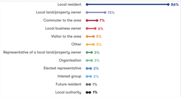
Figure 2-1: Respondents interest in the project
Campaign responses
During our analysis, we identified 75 responses linked to campaigns. These responses featured very similar or identical wording. While similar campaign responses were coded consistently, we treated every response as an individual submission in the overall analysis and reporting.
Age range
The feedback form asked respondents to indicate their age range. A total of 5,340 people answered this question. Figure 2-2 presents a breakdown of responses by age group, offering insight into how participation varied across demographics.
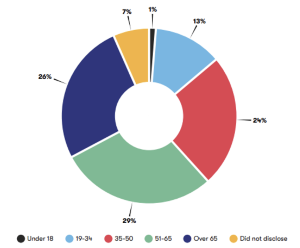
Figure 2-2: Age of feedback form respondents
Location of respondents
As part of the feedback form, respondents were asked to provide their address. A total of 5,625 people chose to respond to this question and shared their postcode. Figure 2-3 presents a heatmap showing the geographical spread of respondents, highlighting participation along the route and beyond.
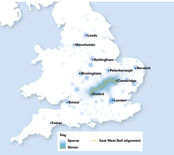
Figure 2-3: Heatmap of location of respondents
3. Route-wide matters
This section reflects feedback received on issues that affect EWR as a whole, not just one location or section of the route. These are referred to as route-wide matters, and include topics like train services, powering trains, our approach to freight and more. They’re important because they shape how the railway would be delivered and operated across the full route from Oxford to Cambridge.
We received a total of 3,307 responses relating to route-wide matters.
Some responses in this section reflect views or interpretations that may not accurately reflect the proposals set out in the consultation. To understand the context behind the feedback presented, it may be useful to refer to Chapter 5 and Chapter 6 of the 2024 Consultation Document. The consultation document and other consultation materials are available on our website: eastwestrail.co.uk/consultation2024
3.1 Train services
|
Sub-theme |
Feedback summary |
|
Train services and operations |
Respondents raised a range of suggestions to encourage train use including ensuring that the cost of train fares is more affordable than driving and other modes of transport. They also suggested frequent, reliable, and fast services are needed, with a minimum of four trains per hour, both express and stopping services to cater to different passenger needs. Integration with other modes of transport (bus and connecting trains) was also recommended. Some respondents questioned the frequency of trains given changes in commuting patterns in the last few years. Further suggestions to improve on current services included extending services beyond Oxford and Cambridge and providing direct connections between key locations such as Bedford and Milton Keynes. Respondents advocated for the electrification of the route alongside the use of modern and accessible rolling stock with level boarding. They also supported the provision of infrastructure for long trains. Additional comments requested high quality facilities at stations and on train carriages such as ramps and accessible toilets, alongside sufficient capacity for passengers, luggage, and bicycles. It was suggested that services should operate late into the night to support the night-time economy and provide flexibility for passengers. There were also calls to have conductors on trains for safety and accessibility, and opposition to driver-only services. Respondents further highlighted the importance of reliable services and door-to-door connectivity. They also requested that access to stations to be improved to make rail travel more attractive. |
|
Journey times |
Some respondents supported the project for its potential to reduce travel times and removing the need to travel to key locations via London or Birmingham. A large number of respondents were supportive of improved connectivity, while others questioned the viability of the proposed route and service pattern in achieving these goals. Several respondents felt that the proposed route was slow and indirect. Several respondents felt that driving may still be quicker than rail journeys, even with the new railway, especially with recent road improvements such as the A428 Black Cat to Caxton Gibbet improvement scheme. They suggested that journey times should be recalculated and the route selection should be reviewed to ensure the railway offers a time advantage over road travel. A small number of respondents raised that two trains an hour might be insufficient for commuters. Rather, faster, direct trains with fewer stops were considered to be more effective by some respondents. There were also suggestions to increase line speeds to 100-125 mph. Regarding the infrastructure proposed along the route, comments highlighted the need to support high speed services including suggestions for dedicated fast lines. |
|
Route capacity |
One respondent felt that two-car trains were inadequate, while others felt that one train per hour in each direction would be insufficient. A small number of respondents raised further concerns about the number of trains running; they felt that four trains per hour would not reach full capacity, and twelve trains running daily would disturb nearby rural villages. One respondent raised concerns about the adequacy of proposed passenger services, suggesting that EWR would be better suited for local commuting rather than long-distance travel. Concerns were also raised by another respondent about the impact of additional trains on existing routes, particularly between Cambridge and London, due to the potential strain on capacity. Many supported the idea of EWR reducing road congestion by moving freight traffic from roads to rail. This included some who emphasised the need to future-proof infrastructure to support growth in both passenger and freight services. Respondents emphasised the importance of sufficient track capacity and passing loops to accommodate freight services, with concerns about the lack of planning for the anticipated increase in freight traffic, particularly from the Port of Felixstowe. Respondents highlighted the strategic need for EWR to connect effectively with major lines and ports, such as Southampton and Felixstowe. |
|
Station design |
One respondent felt that the proposed 150 metre (164 yards) platforms were too short and suggested they should be at least 162 metres (177 yards), to accommodate Class 700 eight-carriage sets. Some comments further suggested that land should be reserved to accommodate 12-carriage trains in the future while others felt this should be included in proposals for EWR from the outset. Respondents also highlighted the importance of future-proofing station infrastructure while also ensuring current passengers are accommodated. This included requests to fully staff stations and ticket offices for security, assistance, and to ensure access is maintained for all passengers, including those with disabilities. There were also specific comments about the limitations of ticket vending machines compared to staffed ticket offices, particularly for passengers with cognitive or physical disabilities. Accessibility was emphasised with calls for accessible platforms and toilets as well as lifts and overbridges. Further comments suggested that station parking should be affordable with electric vehicle charging points in car parks. Comments also suggested enhancements for onward travel by bicycle and bus, pointing to the Elizabeth Line as a good example of ensuring full level boarding at all stations and seamless interchange for passengers. |
3.2 Powering our trains
|
Sub-theme |
Feedback summary |
|
Electrification |
A large number of respondents suggested that implementing full electrification from the outset would better align with the UK's net-zero commitments, reduce lifetime costs, improve operational flexibility, increase the frequency of trains and avoid reliance on diesel. Several respondents supported discontinuous electrification of the line in the context of net-zero aspirations and recognised this demonstrates a commitment to sustainability. Some supported discontinuous electrification as an interim solution, provided it would allow full electrification with minimal disruption in the future. Several respondents supported measures to reduce disruption during construction and reduce visual impacts, such as avoiding overhead line electrification in urban areas and using alternative power systems where feasible. Many respondents raised concerns about the proposed discontinuous electrification of the route, highlighting the environmental, operational, and economic drawbacks. They noted that the use of diesel-powered freight trains could increase pollution, noise, and health risks, particularly in residential and rural areas. Additionally, respondents raised doubts about the reliability and cost-effectiveness of hybrid battery-electric trains, citing that they would have higher maintenance costs, limited performance on gradients and unproven reliability for freight services. A few respondents expressed concerns about the reliability of discontinuous electrification, which they suggested is still a fairly new technology. In comparison, several other respondents felt all trains should be electric or hybrid-electric, and that no diesel-powered trains should be used on the line for either passenger or freight services. Respondents suggested alternatives to discontinuous electrification, including several who advocated hydrogen-powered trains. A large number supported fully electrifying the route to minimise disruption in the future and recommended accommodating freight and electrifying the route in stages. One respondent further recommended using local renewable energy sources. Several respondents emphasised the need to future-proof the railway, making it compatible with existing electrified lines and electrifying freight loops. Respondents highlighted that Ampthill Road may need to be raised to provide enough clearance for the overhead line equipment if full electrification in this area is required. |
3.3 Supplying power to EWR
|
Sub-theme |
Feedback summary |
|
Islip compound |
Several respondents opposed proposals to locate a large compound near Mill Farm within Islip's conservation area. Concerns focused on traffic congestion, narrow roads, the absence of pavements, and the risks to pedestrian safety, particularly children and elderly residents. The compound's size, visual impact, lighting and anticipated noise from cooling units were seen as potentially disruptive to the peaceful enjoyment of nearby homes. There were concerns that construction of the compound could cause significant disruption such as noise and access issues alongside the risk of flooding at the proposed site. Health and safety risks were also highlighted including concerns about interference from electrical equipment and potential health effects linked to electromagnetic interference. Specific worries included the risk of transformer malfunction and the need for this infrastructure to be located away from residential areas and shielded by earth banks to contain any hazards. The decision to locate the compound in a residential and conservation area was questioned further with suggestions that alternative locations with better access and less impact on the community and the conservation area should be considered. Some respondents supported locations for compounds such as Quainton, East Claydon, or Verney Junction substations. Respondents also highlighted the need for effective coordination between infrastructure projects to manage electrical demands, minimise disruptions and ensure access routes are suitable for construction and maintenance vehicles. |
3.4 Stabling trains and maintaining the railway
|
Sub-theme |
Feedback summary |
|
Depots |
A small number of respondents expressed concern about the environmental and community impacts of proposed depot locations, including disruption to local communities, loss of farmland, and potential harm to wildlife such as Barbastelle bats. They suggested reusing or expanding existing facilities instead, such as the existing depots at Northampton and Bletchley, rather than creating new ones on greenfield sites. There was also an emphasis on improving existing depots, including one respondent who described Bedford Cauldwell Depot as being in need of regeneration. Verney Junction was also raised as a potential freight depot, with suggestions to extend the line to Aylesbury to utilise existing maintenance depots and stabling areas. Respondents further questioned the need for new depots, suggesting alternative locations or solutions. This included a few respondents who suggested that depots should be located away from current and future residential areas and sensitive ecological zones. The potential impact on existing depot operations and access was also raised by a small number of respondents, including suggestions to ensure depots have independently operated access points and power supply. A small number of respondents also raised concerns about the inclusion of depot land within the safeguarding boundary, suggesting that focus should be placed on areas closer to existing stations or industrial land. In addition, there was emphasis on the need for collaboration with Network Rail and other stakeholders to ensure minimal disruption and efficient use of resources. |
3.5 Our approach to freight
|
Sub-theme |
Feedback summary |
|
Freight |
Many respondents who supported freight noted that using freight along the route could reduce road congestion, carbon emissions, and reliance on heavy goods vehicles, particularly for container traffic from ports like Felixstowe. This included emphasis on the importance of designing the railway to accommodate future freight growth and ensuring it aligns with national rail freight strategies and opportunities. Some respondents further suggested prioritising investment in infrastructure to support freight while still minimising community disruption. A large number of respondents questioned why and how the EWR line would be used for freight, particularly citing the environmental and social impacts of diesel-powered freight trains. They called for more information about freight plans, including the number of freight trains, their operating hours, and the environmental impact of these services. They also suggested exploring alternative traction technologies such as hydrogen-powered locomotives and ensuring that freight proposals do not undermine passenger services. Respondents further highlighted the need for early engagement with train and freight operators to address timetable impacts and recommended building a direct chord line at Bletchley for a faster Cambridge-Bedford-Milton Keynes service. They also proposed routing freight to bypass Cambridge, with sufficient clearances and alternative traction options to reduce reliance on diesel trains. Finally, concerns were expressed about the impact of freight operations on local residents and passengers, with suggestions to limit freight train movements to daytime hours and ensure they do not disrupt passenger services. |
3.6 EWR Co and the project
|
Sub-theme |
Feedback summary |
|
Need for the project |
A large number of respondents who supported the project felt that it addressed the need for improved east-west connectivity while reducing road congestion and reliance on London transport networks for travel. They anticipated that the project would deliver economic and environmental benefits alongside improved access to education, employment, and leisure activities. Many viewed the project as an important investment for regional and national transport networks, and they urged that it be delivered quickly. The project was also viewed by several respondents as a catalyst for regional development, with hopes of better community integration and infrastructure improvements. Additionally, many welcomed the economic potential of EWR, noting that it could boost job creation, attract investment, and strengthen ties between Oxford and Cambridge’s academic and technology sectors. A very large number of other respondents questioned whether the project was really needed. They called for a transparent business case that clearly considers the cost of all route options, the financial viability of the project, and how it aligns with local and regional development plans. Many respondents raised doubts about whether passenger demand forecasts were still accurate, especially given the increases in remote working following the COVID-19 pandemic. A large number also argued that benefits to local residents would be limited, and many felt that the upgraded A421 dual carriageway and the A428 Black Cat to Caxton Gibbet improvement scheme would offer faster and more convenient travel. Many also felt that EWR would primarily serve freight while several others made comparisons to HS2 with concerns about cost overruns. Many respondents suggested pausing or cancelling the project entirely, and many others argued public funds would be better spent on social care, and improving existing transport systems, such as bus services, road networks, and active travel infrastructure. |
|
Route alignment |
Many respondents suggested that a northern approach into Cambridge could be faster, cheaper, and less environmentally damaging. Additionally, many respondents advocated for the southern route out of Bedford, suggesting it could be cheaper, flatter, and less environmentally damaging, particularly if it avoided floodplain viaducts. Many other respondents stated that the route should not be limited to just the Oxford to Cambridge corridor. There was support for extending the route to serve additional destinations such as Norwich, Ipswich, Felixstowe, Ely, Colchester, Didcot, Cardiff, Swindon, Exeter, Plymouth, Bristol, Bath, Swansea, Gloucester, Cheltenham, Birmingham, Northampton, Aylesbury, Cowley, Newmarket, Chippenham, Waterbeach, Peterborough, Twinwoods and Stansted Airport. Respondents suggested that these extensions would maximise the benefits of the railway by improving regional and national connectivity, supporting economic growth, and providing better access to jobs, housing, and key employment sites. In addition, some respondents queried the Aylesbury Link's exclusion from the Connection Stage 3 proposals, seeking confirmation that its construction remains viable. Alternative suggestions for the route included a bored tunnel, a route parallel to the M11, or making better use of existing transport corridors. |
|
National and local government |
A small number of respondents acknowledged the project's importance for local and regional development and its role in supporting the Government's housing and economic growth objectives. They also noted the Transport Secretary's emphasis on the railway's role in economic growth and supported investments to accommodate freight on EWR. Additionally, a few highlighted unique opportunities to create more jobs and homes through rail investment, contributing to the Government's national growth mission. Respondents questioned the alignment of the project with local and national financial and environmental priorities. A few raised concerns about the initial planning and political decisions for the project, as well as its goals. The decision to designate the project as a Nationally Significant Infrastructure project, meaning it doesn’t follow the same planning approvals as some other projects, was also acknowledged by one respondent. A small number of respondents criticised the impact on local councils, alleging that decision-making has not taken into consideration local development plans and economic needs. Wider concerns were raised by one respondent about the privatisation of rail services, who suggested a fully integrated, publicly owned railway system instead. |
|
Funding |
Respondents supported the project for its potential to reduce road congestion, provide low-carbon transport options, and boost economic growth. Several emphasised the importance of cost-effective and sustainable implementation. Other respondents raised concerns about the allocation of funds for the project, with many suggesting the money could be better spent on essential services such as the NHS, education, social care, and local infrastructure improvements. A small number of respondents raised the cost-of-living crisis, and many cited the need for investment in existing transport systems and in addressing regional disparities. A very large number of respondents shared reservations about the cost and value for money of the project, citing its estimated cost of £7 billion in 2019 for completion in 2027, which was later revised to £5-6 billion for completion in the early 2030s. Several respondents suggested alternative proposals for how to spend the funds, such as enhancing digital infrastructure and supporting local community projects. One respondent suggested that a community benefit fund could be established to support local initiatives and mitigate disruption or effects caused by the proposals. |
3.7 Environment and sustainability
|
Sub-theme |
Feedback summary |
|
Air quality and emissions |
Many respondents raised concerns about the use of diesel trains, which they felt could contribute to air and noise pollution, harming public health. Diesel trains were also seen as incompatible with the UK's net-zero commitments. It was suggested that full electrification of the rail line should be implemented from the outset to avoid reliance on diesel engines, reduce emissions, and align with environmental goals. Many respondents highlighted and supported the potential benefits of shifting freight from road to rail, which could reduce road congestion and vehicle emissions, but some emphasised that this would only be effective if electric trains were used. The construction process was highlighted by several respondents for its potential to generate significant carbon emissions and increase traffic congestion and pollution due to road diversions and additional vehicle use. Respondents requested carbon impact assessments to understand the long-term carbon footprint of the project, including embedded carbon from construction and the impact of associated housing development. Suggestions to mitigate impacts on air quality included integrating sustainable and active transport options for station access, considering the placement of stations to minimise urban air pollution, and exploring renewable energy solutions, such as solar panel installations. Respondents also called for measures to mitigate construction-related pollution, such as dust control and the use of electric construction equipment, and for reassurances about the project's overall environmental impact. Respondents also highlighted the importance of protecting tranquil areas and addressing cumulative environmental impacts, including air pollution. |
|
Operational noise and vibrations |
Many respondents raised concerns about the potential for diesel freight trains to contribute to noise and vibration levels, especially during the night-time. They suggested that freight services should be limited to daytime hours and that the railway should be fully electrified from the outset to minimise noise and vibration impacts. Concerns were also raised by several respondents about the noise impact on residential areas, schools, and the countryside. Several respondents highlighted the potential for health and wellbeing issues and a small number noted disruption to education. A few respondents raised the risk of declining property values due to increases in noise. It was suggested that the railway should avoid running close to residential areas and that the design should consider the impact of elevated tracks and embankments on noise levels. |
|
Water resources and flood risk |
Many respondents raised concerns regarding flooding and water resource management. They raised the risk of flooding linked to construction in floodplains, poor drainage systems, and the potential for surface water runoff to exacerbate existing issues. Areas such as Clapham, Bedford, and Haslingfield were specifically mentioned by a small number of respondents for their susceptibility to flooding. There was also emphasis on the need for comprehensive flood risk assessments, sustainable drainage systems, and floodplain compensation measures. Concerns were also expressed by several respondents about the impact on chalk aquifers, water scarcity and insecurity, and the potential contamination of water bodies during construction. They suggested measures such as rainwater harvesting, greywater recycling, and the use of balancing ponds to mitigate flood risks. The importance of early engagement with water authorities was also highlighted, alongside clear maintenance responsibilities for drainage systems, and the integration of water efficiency standards in station designs. Additionally, many respondents raised concerns about the feasibility of large-scale housing developments associated with the project, citing the region's existing water stress and infrastructure limitations. A coordinated and holistic approach was called for to address water supply, sewage, and environmental impacts before proceeding with construction. |
|
Biodiversity and nature conservation |
A large number of respondents raised concerns about the project’s impact on biodiversity, including the perceived loss of ancient woodlands, established habitats, and green spaces. A small number of respondents argued that tree planting and habitat creation cannot fully compensate for these losses due to the time required for new ecosystems to mature and offset carbon emissions. There was strong support for climate-resilient tree planting, rewilding, and the creation of wildlife corridors, with a call to establish habitats before construction begins. Respondents stressed the need to protect trees, hedgerows, and agricultural land, citing irreversible damage to soil fertility and ecosystems, especially on sensitive chalk soils, and referenced issues seen in the Baldock Road Tunnel project. Several respondents raised concerns about disruption to wildlife corridors, and many respondents also expressed concern about the potential impact on habitats for protected species like Barbastelle bats, with criticism from a small number of respondents that mitigation measures such as green bridges and bat underbridges are inadequate. The proposed route was perceived by several respondents to fragment habitats and threaten rare species. A northern route into Cambridge was suggested by several respondents to better protect wildlife and biodiversity. While some welcomed the project’s alignment with Biodiversity Net Gain and sustainable development, others warned against using land for mitigation at the expense of existing ecological efforts. Respondents called for independent ecological surveys, stronger wildlife protections, new nature reserves, and a firm commitment to habitat preservation. Finally, there were broader concerns from several respondents about insufficient environmental data, pollution risks, and long-term impacts on the countryside and food security. |
|
Landscape and heritage |
Respondents raised concerns about the impact on landscape and heritage, many of whom highlighted the potential loss of countryside, agricultural land, and natural habitats. A small number of respondents also expressed worries about the visual impacts of embankments, viaducts, and overhead electrification infrastructure. It was noted that these features could alter the rural character and tranquillity of affected areas. Concerns were expressed by several respondents about the impact on heritage assets, including listed buildings, conservation areas, and archaeological sites. There were also requests for early archaeological investigations and mitigation measures. A small number of respondents noted the potential for irreversible damage to landscapes and ecosystems. A few also highlighted potential disruption to local communities, including reduced access to green spaces during construction and operation. Specific areas of concern were raised by a few respondents, such as the impact on ancient woodland, historic villages, and culturally significant sites such as Chapel Hill. Respondents requested that EWR minimise visual impacts, preserve green spaces, and ensure sensitive designs to protect the natural and historic environment. |
3.8 Effects on traffic and transport
|
Sub-theme |
Feedback summary |
|
Connectivity |
Many supporters of the project highlighted its potential to improve commuting. A small number specifically anticipated commuting benefits for rural residents. The railway was seen by many as a vital alternative to car travel, offering faster, more reliable connections between Oxford, Milton Keynes, Bedford, and Cambridge. In contrast, many respondents expressed concerns about the project’s impact on connectivity, with several citing issues like community severance in locations such as Hauxton to Little Shelford and Lidlington where longer level crossing closure times could make travel between communities difficult. There were also worries that EWR could reduce access to essential services like schools and healthcare. Several respondents felt door-to-door transport options were unclear and that the number of proposed stations between Bedford and Cambridge was limited. One respondent also felt that accessing key destinations would still require multiple modes of travel. Several respondents believed the route through Cambridgeshire would negatively affect rural areas, isolate villages and increase journey times due to road closures and diversions. There were also several concerns about poor integration with local bus services, with several respondents highlighting inadequate walking and cycling infrastructure. A small number also expressed concern for a potential rise in car dependency. As an alternative approach, respondents suggested a northern route into Cambridge could offer better connectivity and alignment with local development plans. While some supported the project’s goals, they called for a strategic transport plan that improves integration with existing networks and ensures easier station access. |
|
Access to stations |
A small number of respondents raised concerns about the accessibility and practicality of using EWR with comments referring to the lack of nearby stations, particularly between Bedford and Cambridge. They felt that people may have to drive long distances just to access the railway. A few respondents highlighted that door-to-door travel would often be slower and more expensive than driving, especially when factoring in parking fees, train fares, and additional transport to reach their final destinations. Respondents felt that for the railway to succeed, stations must be easily reachable by public transport, walking, or cycling. Many called for better integration with local bus services, improved cycling infrastructure, and adequate station parking to support active and sustainable travel. |
|
Active travel and public rights of ways |
Several respondents expressed support for active travel provisions proposed for EWR. Some highlighted the opportunity for the project to promote cycling and walking, particularly as the route connects three cycling-friendly cities; Oxford, Milton Keynes, and Cambridge. Respondents also commented on the need for comprehensive cycling and walking infrastructure to reduce car dependency, including segregated cycleways, footpaths, and bridleways along the route. This included requests for the project to support cycle-train-cycle journeys, by implementing safe cycle routes alongside secure, free bicycle parking. They also emphasised the importance of maintaining and improving public rights of way and ensuring that any closures are mitigated with accessible alternatives, including grade-separated crossings. Requests were made for more detailed plans to address the perceived severance of existing active travel routes. Respondents also noted the need for inclusive infrastructure, such as footbridges and underbridges that accommodate cyclists, pedestrians, equestrians, disabled people and older people. Suggestions included improving last-mile connectivity, creating a continuous east-west active travel corridor, and integrating cycling infrastructure into station design. |
|
Road journeys |
Several respondents highlighted potential increases in road congestion due to future housing developments, construction activities, and limited access to stations. A small number of respondents predicted that the project could lead to more car journeys, including one respondent who raised rural areas as a particular concern where public transport options are limited, and that nearby housing development proposals would exacerbate traffic issues. Many respondents expressed concerns about road closures, diversions, and disruptions during construction, which could negatively impact daily commutes, increase journey times, and create bottlenecks in local road networks. This included concerns that the proposals could impact emergency services, potentially hindering their ability to operate effectively. The potential for increased train services to cause delays at level crossings was also mentioned by one respondent. Concerns were raised about the impact of construction on local roads, with calls for independent road condition surveys, ongoing repairs, and mitigation of cumulative impacts from other projects. Some respondents requested better integration of sustainable and active transport options, improved road safety measures, and mitigation strategies to address construction-related traffic impacts. |
3.9 Construction and logistics
|
Sub-theme |
Feedback summary |
|
Construction timeline and cost |
A large number of respondents urged EWR Co to focus on delivering the project efficiently and to ensure that the railway is operational as soon as possible to realise its economic and social benefits. This included many who advocated for the northern route into Cambridge over the southern approach due to its perceived lower cost and faster construction timeline. Concerns were raised by a small number of respondents about delays to the project, with calls from some to expedite construction and avoid unnecessary consultations or mitigations that could cause further delays or increase costs. A small number of respondents suggested prioritising sections of the route that could be operational earlier, such as the Bedford to Cambridge section, and a few proposed interim solutions like discontinuous electrification to speed up delivery. One respondent requested that complex construction activities are avoided to ensure the project remains within budget. Some specific design suggestions included closing the Marston Vale Line temporarily, avoiding the proposed passing loops near Cambourne, exploring parts of the project that could be constructed in parallel, and utilising alternative construction methods such as boring tunnels instead of using cut and cover techniques. |
|
Environmental impacts of construction |
Many respondents raised concerns about potential environmental impacts during construction such as air and noise pollution, vibration and dust. They also raised the risk of increased emissions from diesel-powered machinery, which could affect residential areas, schools, hospitals, and wildlife habitats. Further comments from several respondents raised the need of offset carbon emissions embedded in construction activities such as the movement of large amounts of soil. Several respondents noted the potential for long-term damage to agricultural land, ecosystems, and local landscapes, including the disruption of rare species such as Barbastelle bats. There were calls for detailed plans to mitigate air and noise pollution, including monitoring locations, dust suppression measures and noise barriers. Some respondents advocated for restrictions on construction hours, particularly at night and weekends. They also called for a Construction Environmental Management Plan that considers noise, dust, and vibration and structural impacts. Respondents suggested that construction activities should avoid the breeding season to protect wildlife and that alternative routes with less environmental impact should be considered. They also emphasised the importance of delivering Biodiversity Net Gain and adhering to environmental standards by providing assurances on how air quality, noise, and other disruptions would be managed during the construction phase. |
|
Traffic and diversions |
Many respondents raised concerns about the disruption expected during the construction phase of the project. They highlighted issues including increased traffic congestion, road closures, and lengthy diversions, which could negatively impact daily commutes, local businesses, and emergency service response times. Concerns were also expressed by several respondents about the potential damage to local roads from heavy construction vehicles, with requests for pre-construction road assessments and post-construction repairs. A small number of respondents raised that rural and narrow roads are unsuitable for heavy vehicle traffic, and several noted that some areas lack the infrastructure to handle the expected volume of vehicles. Further concerns were raised by a few about the suitability of access roads to construction compounds, particularly in residential areas like Sedley Taylor Road in Cambridge. It was suggested that construction traffic should avoid passing through villages and alternative routes should be identified. The impacts on local villages, including increased pollution and noise from road traffic as well as longer journey times were also highlighted as issues by respondents. A few respondents raised further specific issues including the impact on agricultural access, the need for safe cycle and pedestrian routes, and the potential for rat-running on unsuitable roads during construction. Respondents requested more information on construction traffic routes and the overall impact of multiple infrastructure projects in the area. They called for detailed traffic impact assessments, clear communication about changes, and robust traffic management plans to minimise disruption. There were also recommendations to engage with local authorities and communities to develop effective construction traffic management plans that minimise disruption. Some respondents proposed using the current rail network for material delivery to reduce road traffic and suggested using modern construction techniques, including automation and robotics, to avoid delays. The importance of maintaining access to key services and facilities during construction was also highlighted by respondents. |
|
Construction safety |
One respondent raised concerns about the impact of construction on local road safety, citing existing traffic issues in areas such as Cambridge and Whittlesford, and the risk posed by heavy construction vehicles on local roads. Suggestions for mitigations included the installation of traffic lights at crossroads on Whittlesford Road to manage traffic flow. Specific concerns were raised by another respondent about Haslingfield, a historic village with narrow roads, tight bends, and over 50 listed properties, where they raised that construction traffic could lead to accidents and property damage. Comments suggested minimising excavation and embankment digging to reduce risks, including one respondent who referenced a recent fatal accident in Ravensden involving methane during groundworks. There were also comments from a few respondents relating to reports of poor contractor behaviour during the construction of previous phases of the project. Respondents emphasised the importance of fire, rescue, and ambulance services reviewing proposed construction locations to develop emergency response plans for risks associated with excavations, heavy engineering, tower crane rescues, heavy plant movements, fire hazards from hot works, and the presence of a substantial onsite workforce. One respondent specifically raised concerns about fire safety in both on-site and off-site accommodation, highlighting the potential long-term impacts of offsite facilities even after the project is completed. In addition, there were calls for a detailed Code of Construction Practice, dynamic traffic management plans and independent surveys to assess noise and structural impacts. The appointment of a construction ombudsman to address residents' concerns and 24-hour phone lines for reporting issues were also requested. |
|
Construction compounds |
A small number of respondents raised concerns about the location, size, and impact of construction compounds. Some felt that site access points were poorly planned, with insufficient consideration for safety and wellbeing. Several respondents expressed further concern about the scale of land take for construction compounds. There were requests to make efficient use of land space occupied during construction and use temporary acquisition to reduce impacts on farming businesses. A few respondents highlighted potential noise, dust, and drainage issues. Some suggested specific mitigation measures such as temporary raised banks, positioning noisy vehicles away from residential boundaries, grass-seeding stored earth, and comprehensive noise and dust management plans. Concerns were also raised by a small number of respondents about the impact on agricultural land, with fears of soil compaction, contamination, and long-term unprofitability. There were further reservations from one respondent about the coexistence of construction, farming, and residential access, with some respondents citing health, safety, and security risks. Respondents questioned the calculation of working space sizes and recommended reducing them to avoid unnecessary loss of agricultural land. Further suggestions included ensuring construction compounds are at least 150 metres from residential properties, implementing temporary surface water drainage, and consulting updated planning policies. Respondents also recommended conducting independent noise surveys, establishing a construction ombudsman with a formalised complaints procedure, and levying financial penalties for overrunning clean-up operations. Additional suggestions included limiting construction hours to weekdays between 9:00 to 17:00, repairing damaged roads using pre-construction surveys, and considering community use for areas retained post-construction. |
3.10 Community benefits and impacts
|
Sub-theme |
Feedback summary |
|
Access to jobs, education and healthcare |
Several respondents supported the project's potential to improve connectivity between Oxford and Cambridge, enhance collaboration between universities and businesses, and provide access to affordable housing and job opportunities. They emphasised the importance of frequent, reliable, and convenient train services to maximise the project's benefits. A small number of respondents further recognised that the project could improve public transport links to the Cambridge Biomedical Campus alongside providing better access to healthcare for patients at Cambridge University Hospitals and Bedford Hospital. They also acknowledged that EWR would provide alternative transport options for staff and facilitate better regional collaboration. However, concerns were raised by several respondents about the adequacy of existing bus services, with some expressing concern about the impact of construction on daily commutes. A small number also raised concerns about potential disruption to local villages and access to schools, healthcare, and workplaces. Concerns were raised by a few respondents about the strain on local healthcare facilities and some called for better integration with existing transport systems. Respondents proposed creating more stops along the railway line to improve accessibility and suggested integrating bus services with rail stations to enhance connectivity. Respondents also stressed the need to address localised impacts and ensure the project meets the needs of diverse communities. |
|
Local economy |
Several respondents who supported the project cited its potential to boost economic growth, foster collaboration between academic and business sectors, and improve connectivity across the Oxford to Cambridge arc. Several also noted benefits such as job creation, increased access to talent pools, and enhanced opportunities for innovation and research. A few respondents suggested that the project could attract inward investment. A small number also proposed that EWR may help to support disadvantaged areas, and a few also suggested that it may improve access to affordable housing. In contrast, concerns were raised by a small number of respondents about the potential for disruption to the local economy and businesses during construction, with some questioning the financial and economic value of the project, particularly to the east of Bedford. Several respondents highlighted the risk of traffic congestion, air pollution, noise, and vibration affecting businesses and residents, as well as the impact on farmland, homes, and local shops. A few respondents noted that the project could lead to financial losses for businesses, including those reliant on passing trade, and emphasised the need for compensation for affected parties. Concerns were also raised by a small number of respondents about the adequacy of evidence supporting the project's economic benefits. A few also highlighted the potential for increased housing demand and inflationary effects, and a few others were concerned for the potential impact on local labour markets. Additionally, one respondent felt that ticket prices, in the context of rising living costs, were unsustainable and not supportive of economic growth. Suggestions to help the project support local economic development included integrating the route with key economic hubs like the Cambridge Biomedical Campus, Ipswich, and Norwich, and ensuring connectivity to innovation campuses and rural areas. Respondents also suggested community contributions, such as funding for local amenities, and improvements to local transport infrastructure to offset disruption caused by the project. |
|
Local communities |
Several respondents who supported the project cited potential benefits such as improved connectivity which may strengthen communities and encourage growth, reduced car dependency, and economic opportunities for the region. However, they stressed the importance of addressing local concerns and ensuring equitable benefits for all communities. A large number of respondents highlighted impacts on local communities during construction such as increased traffic congestion, pollution, noise, and disruption. Many also felt that benefits for some villages and affected communities along the route would be limited and some said that they may have to travel further to reach stations due to stations being removed, closed or relocated. This included concerns for Cambourne, Toft, Comberton, and Hardwick. Several respondents also felt that Bedford and its surrounding villages would not get any community benefits from the project. Several respondents also raised concerns about the potential severance of neighbourhoods, and the impact on schools like Comberton Village College. Further comments from several respondents raised concerns that the route between Cambourne and Cambridge could harm rural communities. A few respondents also expressed concern that the route would limit residents’ access to amenities, and several were concerned for negative impacts on property values. Some suggested reconsidering the northern route to Cambridge citing that it would cause less disruption. Respondents emphasised the importance of transparency, independent oversight, and meaningful engagement with affected communities to address their concerns. Some respondents suggested an independent ombudsman should be established for the project to address complaints. There were also recommendations for the project to fund independent property and road condition surveys. Further comments suggested compensation for affected communities and measures to mitigate environmental damage. |
|
Safety and wellbeing |
Many respondents raised concerns about the safety and wellbeing impacts of the project. They highlighted the potential for significant air and noise pollution from diesel freight trains, which could affect the physical and mental health of residents, particularly those near schools and residential areas. The construction phase was raised by several respondents who were concerned about disruption including damage to roads, increased traffic, and safety risks for pedestrians and cyclists. Concerns were also raised by several respondents about the mental health impacts of prolonged uncertainty and disruption for affected residents. One respondent expressed concerns about the risk of increased pressure on healthcare services such as doctors’ surgeries, dentists, and pharmacies, as well as emergency services like police, ambulance and fire and rescue services. Respondents also called for staffed EWR stations to enhance security and assistance, and for modelling to assess the future safety of level crossings. The need for clear communication about safeguarded areas and the health impacts of the project were emphasised Suggestions to mitigate safety concerns included ensuring stock-proof fencing during and after construction, maintaining boundaries and biosecurity for livestock, and providing a buffer zone of at least 150 metres between construction zones and properties. While respondents noted the potential benefits of improved rail connectivity, such as reduced road traffic and enhanced access to cultural and recreational opportunities, they also stressed that these should not come at the expense of local residents' wellbeing. |
|
Impact on equality and protected characteristics |
Many respondents highlighted the potential impacts of the proposals on different groups, including older people, disabled individuals and young people. This included issues such as the need for accessible infrastructure, including step-free access to stations and trains, accessible toilets, and sufficient staffing to assist disabled and older people. Respondents suggested that stations should be fully staffed to enhance security and provide assistance. The need for competitive off-peak travel rates and improved access for younger generations was also highlighted. The proposed route's proximity to schools, such as Comberton Village College, was criticised by several respondents for potential disruption to education, health risks from noise and air pollution, and the lack of mitigation measures. A small number of respondents also expressed a desire for EWR proposals to include improved public transport links to access schools, jobs, and leisure activities, particularly for young people and those without cars. They also emphasised the importance of ensuring that all supporting infrastructure, such as footbridges and under bridges, is designed to be accessible for all users, including those with mobility scooters, wheelchairs, and pushchairs. Respondents further stressed the importance of minimising the environmental and social impacts of construction and ensuring that the project benefits all members of the community. |
3.11 Utilities
|
Sub-theme |
Feedback summary |
|
Utility diversions |
Several respondents raised concerns about disruption during the diversion of utilities such as power lines, gas, water, and telecommunications networks, which serve homes, businesses, care homes, and schools. A small number of respondents also questioned the adequacy of plans to manage this disruption. Respondents highlighted the need for early engagement with utility companies to clarify the extent of utility diversions and minimise impacts on retained land. Specific issues were raised by one respondent about the proposed position of the utility construction entrance near Sunderland Hill and its proximity to listed buildings, with calls to relocate it. Respondents also questioned the necessity of realigning pylons and power lines, suggesting alternatives such as lifting power lines in their current alignment or burying cables to reduce engineering and cost implications. There were also requests for detailed information on the proposed pylon realignment and concerns about the use of recreational areas for construction access. Respondents also suggested exploring alternative power systems, such as battery-powered trains, to avoid lifting power lines. There was emphasis on the need for collaboration with Network Rail and utility companies to ensure that construction of EWR is consistent with existing agreements and that disruption is minimised. One respondent raised objections to specific proposals that would impact local areas, including the safeguarding of land for utility diversions. Concerns were also raised by another respondent about the adequacy of power availability for future growth and the cumulative impact of the project. |
3.12 Homes, land and properties
|
Sub-theme |
Feedback summary |
|
Residential land and properties |
Many respondents raised concerns about the impact of the project on residential land and property. This included several respondents who cited the demolition of houses and a small number who expressed concerns about compulsory land acquisitions. A few respondents also raised the proximity of the railway to residential areas as a concern. Many expressed worries about noise, vibration, light pollution, flooding and air pollution affecting properties during both construction and operation. Respondents requested that no properties are demolished until construction is confirmed, and if works do not proceed, properties should be returned to owners without repayment of compensation. Several respondents highlighted the potential loss of homes and gardens, as well as the disruption to communities and the character of villages which was highlighted by a few respondents. Respondents suggested alternative routes for the railway line, such as the southern approach to Bedford, to avoid house demolitions and reduce the impact on communities. Some respondents argued that the project prioritised large-scale housing developments over the needs of existing communities, with areas not included in local plans being targeted for housing development. Respondents supported the project for its potential to improve housing supply and accessibility, reduce pressure on housing markets, and boost economic growth. However, others emphasised the need to minimise adverse effects on existing homeowners and ensure fair and transparent compensation for affected properties. |
|
Property values |
Several respondents raised concerns about the potential devaluation of homes and properties due to the proposed railway development. A few respondents cited issues such as proximity to the route, noise pollution, visual impact, and construction-related disruption. Several respondents highlighted the risk of properties becoming unsellable or significantly reduced in value, and many requested financial compensation at full market value. A few respondents also requested compensation for additional costs such as relocation, rebuilding, and welfare considerations. One respondent suggested that the project should consider making a voluntary payment of 10% for affected residents alongside property buyouts at market value to mitigate these effects. Concerns were also raised by several respondents about the adequacy of the Need to Sell property scheme and the impact of property blight on residents' ability to sell their homes. Respondents called for prompt and efficient handling of Need to Sell or Want to Sell schemes, with full market value compensation and allowances for disruption and moving costs. Respondents highlighted the need for independent structural and dilapidation surveys for properties near construction areas. A few respondents mentioned the potential for increased property values in areas benefiting from improved connectivity, while a small number of others were concerned about inflationary effects on housing markets due to increased demand. Calls were also made for detailed assessments of housing strategies, compensation mechanisms, and the impact on local property markets. Respondents further raised concerns about the environmental and community costs of the project, including the loss of farmland, nature, and local character, as well as the long-term effects on property markets. |
|
Business land and properties |
A large number of respondents raised concerns about the impact of the project on agricultural land, homes, and businesses. Several respondents highlighted the significant loss of productive farmland, which could affect food security, farming viability, and local economies. A small number of respondents also expressed concerns over the permanent degradation of soil quality. A few respondents noted that the proposed environmental mitigation areas and construction sites would take valuable agricultural land out of production, with some suggesting alternative locations for mitigation areas to reduce the impact on farming. The project was also criticised by a few for its potential to disrupt local road networks, increase travel costs, and create challenges for agricultural traffic. Specific examples included the severance of access to 500 acres of farmland, as well as the impact on farms with long-standing investments in biodiversity and soil health. Respondents also raised the potential for disruption to electricity networks and suggested that EWR Co should fund the relocation of electricity infrastructure in advance of works. Respondents requested engagement with landowners to address access issues, provide suitable alternatives, and ensure that farmland and farm businesses remain viable. Several respondents also raised concern about the adverse effect on businesses. A small number of these respondents raised concerns about specific businesses including the Greenwaste recycling facility, Cambridge Railyard student accommodation development and Royal Mail operational facility which are within the project boundary. |
|
Landowner engagement |
Respondents recognised the need for early engagement with landowners, transparency in dealings, and regular communication to address issues such as impact on land use, land required for environmental mitigation, and accommodation works. Respondents requested clarification on the distribution of Land Interest Questionnaires to properties specifically located near the Newmarket Line, questioning their relevance given the distance from the proposed railway alignment. They also asked for support with planning applications to replace demolished agricultural buildings and sought guarantees to secure or maintain access to retained land. Respondents also requested clarity on survey requirements and refinement of survey areas.
|
|
Planned and future developments |
Several respondents supported the project for its potential to improve connectivity and support housing delivery but emphasised the need for a coordinated approach to integrate the project with local plans and mitigate its impacts. Additional comments suggested that EWR could help to improve existing strains including one respondent who highlighted the lack of affordable housing in the proposed developments. A few respondents also felt that EWR could mitigate increased traffic that is expected due to new housing developments. It was also proposed that stations should be located near significant housing developments and that transit-accessible land should be prioritised for mixed-use developments rather than car parks. In contrast, many respondents were concerned that the project could lead to more large-scale housing developments, particularly in areas like Bedfordshire, Cambridgeshire, and Milton Keynes, which are already facing challenges such as water shortages, insufficient infrastructure, and traffic congestion. Respondents questioned the justification for the railway, suggesting it prioritised supporting housing development over community needs and environmental considerations. Many respondents noted that planned housing developments nearby would increase road traffic, strain local resources, and exacerbate existing issues with water supply, sewage systems, and access to essential services like schools and healthcare. Concerns were also raised about the environmental impacts by several respondents highlighted the loss of green belt and arable land. A small number were also concerned about increased pollution, and a few cited the loss of rural landscapes. A small number of respondents objected to the extent of proposed land take by the project in areas where they felt it would hinder adjacent development opportunities. Suggestions included prioritising a northern route into Cambridge which was considered to better align with existing housing plans, ensuring compatibility with local development strategies. Additionally, respondents requested that water security and infrastructure needs are addressed before the project proceeds. Further comments included calls for the safeguarding of land for future residential developments and ensuring that station designs align with local planning policies. |
|
|
|
4. Oxford to Bletchley
This chapter presents feedback received on proposals for the Oxford to Bletchley section of the route, which spans approximately 48 kilometres (30 miles) and includes proposals for Oxford station, Oxford Parkway, Bicester Village, Winslow, and Bletchley stations, and other infrastructure features including proposals for the level crossing in Bicester. It builds on improvements already underway between Bicester and Bletchley, supporting the planned increase in EWR services.
A total of 2,384 responses were received about this route section.
Some responses in this section reflect views or interpretations that may not accurately reflect the proposals set out in the consultation. To understand the context behind the feedback presented, it may be useful to refer to Chapter 8 of the 2024 Consultation Document. The consultation document and other consultation materials are available on our website: eastwestrail.co.uk/consultation2024
4.1 General route section
|
Sub-theme |
Feedback summary |
|
Route alignment |
Questions were raised by several respondents about the route alignment, particularly the lack of a connection to Aylesbury, which they believed would enhance connectivity to Milton Keynes, Oxford, and London, and reduce road traffic and air pollution. Respondents suggested that the Aylesbury link should be reinstated to connect High Wycombe, Aylesbury, and Milton Keynes, and to provide better access to the Chiltern Main Line. Some respondents also expressed disappointment over the absence of a connection to the Cowley Branch Line in Oxford, which they argued would improve access to key employment and innovation hubs, such as the Oxford Science Park and Oxford Business Park, and support economic growth. Respondents suggested the route should integrate with existing rail networks, including the West Coast Main Line, Great Western Main Line, and HS2, to enhance regional and national connectivity. They also highlighted the need for additional stations to serve smaller communities, such as Steeple Claydon, Wendlebury, and Charndon, to improve door-to-door connectivity and reduce road vehicle journeys. Respondents proposed extending services to Didcot, Swindon, and beyond to improve connectivity in South Oxfordshire and the south-west, and to reduce rail congestion at Oxford station. |
4.2 Oxford station
|
Sub-theme |
Feedback summary |
|
Station enhancements |
Several respondents expressed support for the station enhancement works already proposed by Network Rail, supporting the creation of a new western entrance, additional platforms, and improved public areas to enhance the station's role as a multi-modal transport hub. One respondent was concerned that the capacity of Oxford station may not be able to handle the proposed four EWR trains per hour and so highlighted support, alongside a few other respondents, for significant upgrades to the station to accommodate increased passenger numbers and services. The importance of aligning the station's development with the Oxford Station Masterplan and Oxfordshire Rail Corridor Study was highlighted, which includes provisions for additional platforms in the future, improved facilities, and enhanced connectivity. A small number of respondents mentioned the reopening of the Cowley Branch Line and its integration into EWR to improve connectivity and reduce pressure on Oxford station. Respondents expressed the need for active travel options, including secure and sufficient cycle parking, improved pedestrian and cycling infrastructure, expansion of the existing train crew facility and the minimising of car dependency. Respondents also stressed the importance of ensuring accessibility around the station for wheelchair users, prams and people with luggage. Other suggestions were made to avoid locating staff parking in central Oxford due to constrained land, and instead to explore alternative locations such as Oxford Parkway. Concern was also expressed about disruption associated with constructing the station enhancements to users of the station. Respondents also emphasised the need for EWR Co to engage with local authorities and the rail industry to address capacity constraints and ensure the timely delivery of infrastructure improvements. |
4.3 Station upgrades
|
Sub-theme |
Feedback summary |
|
Oxford Parkway station |
A few respondents raised concerns about the potential impact of the redevelopment at Oxford Parkway station and the impact of proposals for car parking on local landowners. They noted that the existing car park is underutilised and instead suggested that additional parking could be achieved by adding extra levels on existing land. Concern was also raised by a small number of respondents about the incompatibility of the current aggregates haulage depot with the safe operation of the station car park and access to Oxford Road. Respondents highlighted the need for improved connectivity, including enhanced pedestrian and cycle access, better bus services, and active travel infrastructure. There was an emphasis on the importance of redesigning the station entrance to address safety issues, particularly for cyclists and pedestrians, including proposals for a new access point and improved junction design. Respondents also suggested that upgrades should include accessible facilities for people with mobility aids, prams, and bikes, as well as enhanced cycle parking and storage. Some respondents supported the redevelopment but requested to see Oxford Parkway enlarged to be the main station for the project, commenting that Oxford station is already overcrowded. Respondents questioned the need for a turnback facility, suggesting that services should run through to Oxford and beyond to Didcot. However, others supported the turnback facility and improvements to the track and passing loops. Respondents also noted the need to future-proof the station for potential A34 enhancements and the importance of integrating the station with nearby developments, such as the Digital Innovation District and the proposed Oxford United Football Club stadium. |
|
Oxford Parkway utility diversions |
A few respondents raised concerns about the potential impact of the proposed diversion of overhead electricity lines at North Oxford Golf Club, particularly regarding the safeguarding of land and construction access. Respondents requested more detailed information about the plans, including the realignment of pylons and power lines, and questioned why the power lines could not be lifted in their current alignment instead of introducing a bend, which they believed could pose engineering and cost implications. Respondents suggested that alternative power systems, such as battery-powered trains, could eliminate the need to lift the power lines, which would minimise site impact and reduce costs. Respondents proposed replacing the power lines with buried cables as an alternative if lifting them in their current alignment was not feasible. One respondent supported the relocation of only the pylons immediately adjacent to the station and emphasised the need for more in-depth research into the upgrades. |
|
Bicester Village station |
A small number of respondents supported the upgrades to Bicester Village station as a way to accommodate future demand from EWR services. Suggestions were made to improve access to the station including maintaining access to the London Road side, and considering upgrades to nearby access roads. They also highlighted the need for sustainable transport options, such as improved bus connections, cycle parking, and pedestrian access, and emphasised the importance of accessibility for wheelchair users, prams, and luggage. A few respondents raised concerns about the accessibility of the car park for the station for residents on the eastern side of the town, predicting increased parking issues and traffic congestion. Respondents questioned the necessity of upgrades at the station, citing recent improvements and current usage levels. Concerns were also expressed by a few respondents about the impact of upgrades on local traffic and accessibility for residents, with some respondents suggesting the station is relocated or a hub station is created on the outskirts of town. Respondents asked for sufficient parking capacity and for daily parking rates to be considered. Some suggestions included alternative parking solutions, such as converting the nearby Shell garage or building an underground car park. They also requested an assessment of key facilities, including platform and overbridge capacity, toilets, and waiting areas, to support higher passenger numbers. |
|
Winslow station |
A few respondents expressed the importance of accommodating increased passenger numbers through upgraded facilities, expanded parking provision, and enhanced connections to other transport modes at Winslow station. There was support by one respondent for the station and its car park to remain fit for purpose and future-proofed, suggesting that any upgrades should align with current policies. Clarity was requested on the anticipated increase in passenger numbers, and the design of station improvements. Landscape and light use mitigations were also identified as necessary considerations for any significant amendments to the station design. Respondents noted the need for a comprehensive mobility hub, secure and covered cycle storage, and improved crossing facilities on the A413 to connect with the Buckingham to Winslow cycle route. Respondents highlighted the need for good accessibility into and around the station for wheelchair users, prams, pushchairs, and wheeled luggage. Other respondents suggested the station serve as a transport hub for the wider community and flagged the importance of integrating the station with sustainable transport options, such as bus services, cycling infrastructure, and pedestrian connectivity, to reduce car dependency. One respondent voiced their concerns about the proposed platform length at Winslow station potentially limiting train capacity and passenger numbers. Concern was also expressed about the potential negative impacts of increased traffic on local roads, particularly the A413 and its junction with the A421, with respondents expressing the need for mitigation measures. Concerns were also raised by one respondent about the impact of construction and operational arrangements on the local transport network and heritage assets near the station. Respondents emphasised the need for the station to operate with minimal disruption and for the transport assessment to account for extended parking and trip generation to Winslow station. Others sought details on how parking expansion would be achieved, including the potential for surface-level or decked parking, and the associated construction impacts. |
|
Bletchley station |
Respondents highlighted current accessibility of Bletchley station, particularly for those with mobility issues. They commented on the need for improvements to accommodate increased demand from EWR services, including parking availability and the need for sufficient cycle storage. A few respondents noted that the current footbridge at Bletchley station is narrow and suggested it should be widened or replaced to improve circulation and access to the EWR platforms. Several respondents emphasised the importance of integrating the station visually with the surrounding streets and ensuring active travel options, such as safe walking and cycling routes, are included. Many respondents suggested that an eastern entrance to Bletchley station should be prioritised to improve access for residents east of the railway, provide a direct link to the bus station, and to enhance connectivity with the town centre and Queensway. They highlighted the potential economic benefits of an eastern entrance, including better access to local businesses and the Brunel Shopping Centre. A few respondents also suggested incorporating train stabling facilities at Bletchley station. A few respondents agreed with the need to expand the west ticket hall, widen platform 6, and add a lift to platform 6 to ensure full accessibility. One respondent raised a concern about the safety and usability of the station at night, with suggestions for improved lighting, improved cleaning facilities, and a new footbridge combined with the proposed ticket hall to enhance the station's functionality and safety. Respondents encouraged collaboration between EWR Co, Network Rail, and Milton Keynes City Council to ensure the proposed changes meet the needs of the community and align with broader transport and regeneration plans. |
4.4 London Road level crossing, Bicester
The question we asked
At London Road level crossing in Bicester, we proposed closing the crossing and presented two options for an accessible replacement for pedestrians, cyclists, and other non-motorised users to allow safe, easy access to Bicester. These options were:
- Option 1a – provide a footbridge with ramps and stairs
- Option 1b – provide an underpass
For both options road traffic would be rerouted via existing roads, with local road improvements to reduce journey times.
We asked respondents to share their preference between Option 1a and Option 1b, as well as giving the choice to respond with ‘No preference’ or ‘Other’. The feedback we received is shown in Figure 4-1.
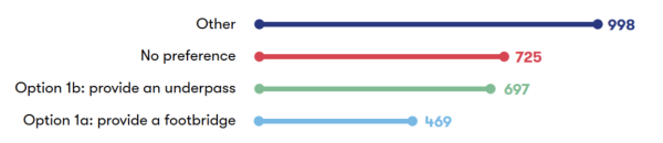
Figure 4-1: Numerical break down of responses to question 5a
A total of 2,889 respondents shared their preference for maintaining access for pedestrians, cyclists and other non-motorised users at the London Road level crossing in Bicester. More respondents expressed a preference for Option 1b, an underpass (24%) than Option 1a, a footbridge (16%). The largest proportion of respondents to this question (35%) selected ‘Other’. A further 25% expressed no preference.
We also provided respondents with the opportunity to submit comments about this proposal; these are summarised in the table below.
|
Sub-theme |
Feedback summary |
|
Closure of Bicester London Road level crossing |
Some respondents supported the London Road level crossing closure, noting benefits such as safety improvements and reduced traffic in the town centre. However, they emphasised the need for pedestrian and cyclist access through a footbridge or underpass. A very large number of respondents expressed opposition to the proposal to close the crossing and provide a road diversion for vehicles. A very large number of concerns were raised about the impact on traffic congestion, with a large proportion of these respondents stating that alternative routes are already overburdened, such as the A41, Launton Road, and roads near Bicester Village. They were concerned that this would lead to longer journey times, higher fuel costs, and environmental consequences from additional emissions. A large number of respondents criticised the lack of viable alternatives for vehicles. Respondents questioned the adequacy of the proposed diversions, highlighting the town’s rapid growth with ongoing and planned developments. They referenced past temporary closures that caused significant traffic delays as evidence of potential disruption. A large number of respondents also stated that closing London Road level crossing would divide the town in two, impacting access for residents, businesses, and emergency services. Several respondents raised concerns about the impact the closure would have on older people, disabled people, and those reliant on public transport. The negative impact on residents of Langford Village, Graven Hill, and nearby villages was also highlighted. Respondents wanted a reconsideration of the proposal to ensure that vehicular access is maintained to prevent adverse impacts on the community and local infrastructure. |
|
Option 1a (footbridge) and Option 1b (underpass) – Preference |
Many respondents opposed both options 1a and 1b, stating that they do not adequately address the needs of the town, particularly the requirement for vehicular access. While several respondents opposed the option of an underpass due to flooding risks and a few highlighted maintenance concerns, many others supported it as a long-term solution for maintaining connectivity and promoting active travel. Some respondents preferred a footbridge for its perceived safety compared to an underpass, particularly at night, but emphasised the need for adequate lighting, visibility, and features such as ramps, lifts, and clear signposting to ensure accessibility and safety. Many respondents raised concerns about the visual impact of a footbridge, with respondents describing it as unsightly and intrusive, particularly in a town with historic properties and a designated conservation area. There were concerns about the potential of the footbridge to divide the town, rather than unite it, due to its aesthetic impact. Suggestions for the crossing included maintaining the current level crossing with adjusted barrier timings, constructing a vehicular underpass or bridge, or exploring other engineering solutions to retain vehicle access. Some respondents proposed limiting access to light vehicles, implementing traffic management measures to reduce congestion or exploring options for a new road crossing at Gavray Drive. Some respondents expressed no preference between a footbridge or underpass for pedestrians and cyclists, provided the solution is accessible and safe. |
|
Option 1a (footbridge) – User access and safety |
Respondents raised concerns about the proposed footbridge for pedestrians and cyclists, with a large number citing issues of access, safety, and practicality. It was noted that the footbridge may increase walking distances and effort, particularly for residents of Langford Village, and could discourage walking and cycling, leading to increased car use. A large number of respondents raised accessibility concerns for older people, people with mobility issues, wheelchair users, parents with pushchairs, and cyclists, with concerns about steep ramps, stairs, and the overall height of the footbridge. A few respondents also mentioned that the design could create barriers for active travel and community connectivity, particularly for vulnerable groups. Specific safety concerns included risks of accidents due to shared spaces for pedestrians and cyclists, impacts on privacy for neighbouring properties, and challenges with using the footbridge in bad weather (such as wind, rain and ice), which could make the bridge hazardous. Several respondents highlighted that existing footbridges in the area, such as those near Garth Park and Launton Road, are unpopular due to their design, maintenance issues, and difficulty of use. |
|
Option 1a (footbridge) – Cost and timeline |
Several respondents believed that a footbridge would be a cheaper, quicker, and less disruptive option compared to an underpass, with some stating that it would be easier to construct, maintain, and adapt for future needs. A few respondents raised some concerns about the cost and a few highlighted their concerns for disruption associated with the proposed footbridge. Some respondents noted that it might require significant maintenance, citing the condition of the existing bridge at Tubbs Crossing as an example. Many concerns were also expressed about the aesthetics of the proposed footbridge, which was described as a ‘cheap’ option. Some respondents suggested alternative solutions, such as improving all walkways across the parkland south of the railway line to the existing overbridge at the east end of Garth Park, which could potentially eliminate the need for a new pedestrian footbridge. |
|
Option 1b (underpass) – User access and safety |
Many respondents highlighted that an underpass would provide better accessibility, especially for those with mobility issues, due to the absence of steps and steep inclines. They emphasised the need for good design, adequate lighting, straight and wide paths, proper drainage, and safety features like CCTV, clear sightlines, and anti-loitering measures. Suggestions included making the underpass short, direct, and visually appealing, with references to successful designs in the Netherlands. A few concerns were raised about increased walking distances. Several respondents raised flooding risks, night-time safety, and potential for antisocial behaviour. Access for all users, including those with disabilities, pushchairs, and bicycles, was highlighted as essential. Respondents also stressed the importance of integrating the underpass with the town’s active travel network and minimising its impact as a barrier between Langford Village and Bicester town centre. Some questioned the exclusion of vehicles and its effect on traffic flow. Collaboration with stakeholders was recommended to address technical challenges and reduce construction disruption. |
|
Option 1b (underpass) – Cost and timeline
|
Respondents raised concerns about the cost and feasibility of constructing the proposed underpass, several noted that it would likely be more expensive and a few noted that it would take longer to complete compared to a footbridge. Several respondents expressed a preference for an underpass despite acknowledging its higher cost, while others suggested prioritising the cheapest or easiest option to construct. Concerns were also raised by a few respondents about the potential disruption during construction and the engineering challenges associated with building an underpass. Some respondents criticised the underpass proposal as a waste of money and were discontent with the closure of the London Road level crossing to begin with. Others argued that costs should not be a constraint for the London Road solution. There were also comments about the aesthetic and practical challenges of implementing an underpass, with some respondents suggesting that a shorter underpass could be a more cost-effective solution. |
4.5 Infrastructure features
|
Sub-theme |
Feedback summary |
|
Islip track layout |
Support for the passing loops was expressed by several respondents who recognised the role of the loops in increasing capacity, improving service efficiency, and accommodating freight traffic. The inclusion of passing loops was seen as essential for the line’s future expansion and operational resilience. One respondent supported the specific location of the Islip east loop due to its reduced ecological impact compared to other options. Concerns were raised about the necessity of passing loops given the dual track between Oxford and Bletchley, with some questioning the cost-benefit analysis and the justification for four trains per hour. Specific objections were made by a few respondents to the proposed location of the passing loop near Islip, citing potential noise, vibration, and environmental impacts, particularly on nearby properties, listed buildings, and conservation areas. A small number of respondents highlighted the potential impacts on Islip residents, walkers on the Oxfordshire Way, and local amenities such as the school and medical practice. Specific concerns included noise from idling freight trains, diesel fumes, increased traffic during construction, and safety risks for pedestrians. The visual impact of the passing loop and associated structures was also noted, with requests for screening measures such as tree planting and sound barriers. Some respondents suggested conducting baseline noise assessments and implementing flood risk mitigations. The need for detailed technical and environmental assessments was highlighted due to the potential impact of construction on existing passenger services. Rather than building new loops, the use of the existing loops at Bicester West and Calvert/Claydon was recommended by one respondent as a potentially more cost-effective option. |
|
Middle Claydon track layout |
Several respondents supported the inclusion of the passing loop at Middle Claydon to improve capacity and resilience for both passenger and freight services, noting its importance for operational efficiency and economic benefits. Concerns were raised by a few respondents about the proposed passing loop, citing potential impacts on air quality, noise, vibration, health, landscape, historic environment, and water resources. The proximity of residential properties was highlighted, with concerns about increased noise, vibration, and air pollution from idling freight trains. The impact on heritage assets, including Claydon House and its surrounding parkland, was noted by a few respondents, with potential changes to views and the historic setting. Additionally, environmental impacts were cited including vegetation loss, watercourse changes, and potential archaeological disturbances. Some respondents questioned the necessity of the passing loop, given the limited number of stations and the unclear justification for freight traffic levels. Some respondents suggested alternative locations for the passing loop, such as moving it further south or towards Verney Junction, to minimise disruption to populated areas. |
4.6 Environment and sustainability
|
Sub-theme |
Feedback summary |
|
Air quality and emissions |
Many respondents raised concerns about the environmental impact of the proposed closure of the London Road level crossing in Bicester. It was noted by many respondents that the closure could result in increased congestion and longer journey times due to vehicles idling in traffic jams, causing additional environmental and safety concerns including increasing fuel consumption, carbon emissions, and air pollution. These concerns were emphasised in residential areas and near key locations such as Bicester Village and along Queens Avenue, which already experience high pollution levels. Respondents suggested improving connections to Bicester Village to decrease road traffic between Oxford and Bicester Village. More generally, it was noted that the project may have a negative impact on air quality during both construction and operational phases, including through generation of construction dust and the increased freight train services per hour. Some respondents felt that the project contradicts national carbon reduction objectives, such as the Net Zero Strategy, and asked for measures to be implemented that address changes in air quality. This included considering opportunities to improve local and regional public transport services, which could help to reduce the volume of private vehicles on local roads and therefore reduce road traffic and emissions. There were also calls to look at how the Oxford station enhancements could reduce polluting stoppages of diesel freight trains through Oxford, with hopes that additional capacity could free up space and reduce rail traffic. |
|
Operational noise and vibrations |
Respondents were concerned about noise and vibration impacts from the operation of the project, including noise from idling freight trains, particularly during nighttime hours, which could disturb sleep and disrupt the peace in residential areas, care homes, and public spaces like parks. Vibration from heavier and more frequent trains were noted as a potential risk to the structural stability of nearby buildings, including heritage listed properties, schools and utilities such as gas and water pipes. Specific areas of concern included Bicester, Middle Claydon south of the Waterways housing estate. One respondent expressed concern about the lack of proposed noise barriers around the Islip passing loop and its elevated position on a raised embankment, which could exacerbate noise impacts. They asked EWR Co to conduct baseline noise and vibration assessments, consider mitigation measures including noise barriers and soundproofing and suggested that compensation is given for any damage caused by vibrational impacts. |
|
Water resources and flood risk |
Several respondents were concerned with the risk of flooding associated with the project, particularly around the proposed underpass option at London Road and the proposed traction power compound near Mill Farm in Islip. It was noted that underpasses and tunnels are prone to flooding and may require anti-flood measures, such as pumps, to remain functional. A small number of respondents highlighted that the Middle Claydon passing loop may have impacts on water resources and flooding, and that the railway embankment and culverts have historically exacerbated flooding issues by acting as barriers to water flow. Other areas, including Mill Street in Islip, Wendlebury, and the vicinity of Gallos Brook, were also identified as prone to flooding, with existing inadequate drainage and poorly designed culverts noted as contributing factors. A few concerns were also raised about the potential loss of floodplains, with one respondent specifically flagging the loss of grazing marsh habitat at Islip and the potential for pollution in aquatic environments to harm wildlife. Respondents suggested that enhanced drainage infrastructure, natural flood management techniques such as tree planting, and a comprehensive flood risk assessment should be included in the project. It was recommended that surface water drainage strategies should use sustainable drainage principles and consider the impact of embankments and ground level changes on water flow. Additionally, respondents highlighted that access to certain areas, such as Mill Street, could be severely impacted by flooding, and that construction and operational access routes should factor in these risks. The need for mitigation measures to offset the impacts on watercourses, including watercourse and corridor enhancements, was also emphasised. |
|
Biodiversity and nature conservation |
A small number of respondents raised the removal of trees and greenery during construction as an issue, and some emphasised the need for replacement planting and ensuring the survival of young plants. Concerns were expressed by one respondent about the potential felling of a landmark 100-year-old sycamore tree in Islip, a local landmark within a conservation area, to facilitate access to a field. Respondents highlighted the importance of preserving mature trees at the Oxford Parkway station junction and minimising vegetation removal to protect the semi-rural character of urban fringe areas, including canal and river meadow edges. Arboricultural surveys were recommended to inform design choices and mitigation. Several respondents noted risks to wildlife including species displacement and habitat degradation, and emphasised the importance of preserving biodiversity, such as the Bechstein bat population in Sheephouse Wood Site of Special Scientific Interest and in Middle Claydon. Respondents emphasised the need to avoid damage to Sites of Special Scientific Interest, ancient woodlands, and other important habitats, including nature reserves, floodplains, and ecological compensation sites. Respondents requested detailed information on proposed mitigation and compensation, as well as species surveys to assess ecological impacts. Concerns were raised by one respondent about the combined effects of the HS2 and EWR projects on biodiversity, particularly bats, and the need for additional assessments and mitigation. Specific concerns were also raised by one respondent about the character and ecology of the Oxford Canal and Grand Union Canal, as well as the overlap of Biodiversity Net Gain provisions with existing Network Rail environmental commitments. |
|
Landscape and heritage |
Many respondents raised concerns about the impact of the project on landscape and heritage. The project was seen as potentially harmful to the character and views of conservation areas, listed buildings, and green belt areas by several respondents. Respondents requested detailed assessments and mitigation measures to address these impacts, including the preservation of heritage assets and minimisation of visual and environmental effects. One respondent was critical that the closure of the London Road level crossing may cause people to drive down the Kings End Road instead, which is a designated conservation area. The London Road level crossing was highlighted by a small number of respondents as being significant in Bicester’s railway heritage, with concerns that its closure would erase local history. A small number of respondents opposed the construction of a footbridge at the level crossing due to its potential to overshadow nearby historic buildings, including the Grade II listed Station House. One respondent also noted the footbridge’s visual unsuitability as it borders the Bicester Conservation Area. It was requested that the footbridge’s design should be sensitive and aesthetically suitable for the area. The Middle Claydon passing loop was criticised by a few respondents for its potential visual impact on heritage assets, including the Grade II listed St Michael’s Church, Grade II listed Manor Farmhouse, and the Claydon Estate, a Grade II registered park and garden. Concerns were also raised by a small number of respondents about the proposed traction power compound near Mill Farm in Islip, which may affect the Islip Conservation Area, remove the landmark 100-year-old sycamore tree, and disrupt the rural character of the village. |
4.7 Traffic and transport
|
Sub-theme |
Feedback summary |
|
Connectivity |
Many respondents supported the project for its potential to improve regional connectivity, linking Oxford, Cambridge, and other areas, and providing better access to public transport for non-drivers. The economic and social benefits of enhanced rail connectivity were also noted. Several respondents commented on improved access to employment, education, and leisure opportunities. However, they emphasised the need for careful planning to ensure door-to-door connectivity, including integration with bus services and active travel options, to avoid severing communities. Several respondents were concerned that the closure of the London Road level crossing in Bicester would divide the town, cutting off areas such as Langford Village, Graven Hill and surrounding villages from the town centre, reducing connectivity for over 5,000 households. They stated that this would lead to increased congestion on alternative routes, longer travel times, and difficulties accessing essential services, schools, and care homes. To maintain connectivity, respondents asked EWR Co to construct a road bridge to maintain vehicle access and avoid works in residential areas with limited access. Several respondents highlighted the negative impact on public transport, with bus routes requiring significant diversions, and the potential for increased isolation of vulnerable community members. |
|
Access to stations |
Respondents asked EWR Co to consider improving access to stations as proposals are developed. A large number of respondents were concerned that the closure of the London Road level crossing would result in longer journeys to access Bicester Village station and the town centre. Concerns were raised by a few respondents about inadequate cycle parking, unreliable bus services, and the lack of footpaths and lighting on roads leading to stations. The steepness of proposed footbridges was also cited as a concern by one respondent. |
|
Active travel and public rights of way |
Respondents suggested that improved rail provision should not come at the expense of active travel infrastructure and requested measures to promote sustainable transport, such as accessible underpasses, continuous active travel routes, and high-quality cycle and pedestrian facilities. Respondents called for secure cycle parking and enhanced pedestrian connectivity, particularly at Oxford Parkway and Bicester Village stations. Respondents also highlighted the importance of integrating active travel options, including cycle paths, pedestrian routes, and bridleways, alongside the railway. Several respondents highlighted that the closure of the London Road level crossing could potentially discourage walking and cycling and increase reliance on cars. Some noted that alternative routes, such as the green bridge and Garth Park bridge, were considered unsuitable due to increased distance, darkness, and inaccessibility for those with mobility issues. Some respondents requested assurances that public rights of way, including footpaths and bridleways, would be preserved and accessible throughout the construction period and beyond. |
|
Road journeys |
Some respondents supported the project for its potential to reduce road traffic and pollution, while emphasising the need for comprehensive planning to address the adverse effects on local road networks. A large number of respondents were concerned that the proposed closure of the London Road level crossing in Bicester could exacerbate existing traffic problems on alternative routes, including Launton Road, Queen’s Avenue, and the A41. Some of these respondents noted that these routes are already heavily congested, particularly during peak road hours and busy shopping periods at Bicester Village. Further concerns were raised by several respondents about the impact of road closures on commuting journeys, particularly the extended travel time to train station car parks. Respondents emphasised the need for a comprehensive traffic impact assessment and for measures to mitigate the increased congestion. Interventions suggested to reduce impacts on road journeys included upgrading local roads, providing alternative vehicle routes and implementing traffic calming measures. |
|
Rail journeys |
Several respondents highlighted the need for faster and more frequent trains, with a few supporting four trains per hour. Others questioned the necessity of this and a few suggested two trains per hour would be sufficient. One respondent raised concerns about capacity constraints at Oxford station. Another respondent commented concern for platform length restrictions at Winslow, and the potential underestimation of future demand due to proposed housing developments. |
|
Freight |
A few respondents highlighted the strategic importance of the route for freight, connecting key lines and supporting economic growth, while also advocating for the prioritisation of freight on rail to reduce road traffic and associated emissions. Some respondents also suggested infrastructure enhancements to maximise freight capacity. Concerns were raised by several respondents about the impact of freight trains, including noise, vibration, and pollution, particularly from idling and slow-moving trains near residential areas. Concerns were raised about the potential for disturbed sleep, property damage, and environmental pollution, as well as the reliability of assurances regarding freight train operations during night hours. Suggestions to improve freight opportunities included enhancing infrastructure to meet future freight demand and align with government freight growth targets. Respondents also noted the need for planning and timetabling to align freight paths with connecting lines. |
|
Train services |
Respondents commented on the future affordability of train fares, emphasising that high costs make train travel inaccessible for families, low-income individuals, and pensioners, and discourage a modal shift from road to rail, which they stated is essential for achieving carbon reduction goals. The importance of ensuring affordable fares to encourage usage and support sustainable travel was highlighted. Respondents also stressed the need for reliable, regular, and comfortable train services with adequate capacity to accommodate increased demand, particularly at larger stations like Milton Keynes. Suggestions were also made to improve the design of trains and stations to better accommodate bikes, including proper cycle storage on trains and at stations and ensuring space for bikes without the need for advance booking. Respondents expressed a preference for longer trains, such as six or eight-car trains, to avoid overcrowding and ensure sufficient capacity, and commented on the need for sufficient staffing levels at stations, prioritisation of faster journeys, minimal disruptions, and passenger amenities. |
4.8 Construction and logistics
|
Sub-theme |
Feedback summary |
|
Construction timeline and cost |
Several respondents emphasised the need for swift completion of construction works to minimise the duration of disruption. A few respondents asked for priority to be placed on completing Bletchley to Bedford upgrades and Oxford station works, including the construction of platform 5 as part of Network Rail’s Oxford Corridor Phase 2 Project. Respondents were also concerned about the impacts of future construction stages across the route section, recalling previous construction activity in Bletchley that caused prolonged disruption worsened by poor contractor behaviour, and insufficient communication from project representatives. Questions were raised about delays in opening the line, despite completed infrastructure, with calls to start running services between Oxford and Bletchley/Milton Keynes as soon as possible. |
|
Environmental impacts of construction |
The environmental impact of construction, including noise, vibration, and waste management, was criticised, with calls for adherence to the waste hierarchy and better mitigation measures. Recommendations included that the project should prioritise minimising negative environmental impacts and enhancing biodiversity, for example by using noise barriers, planted mounds, and visual screening to reduce the impact of construction on nearby communities They also emphasised the need for the project to show continued consideration for minimising CO2 emissions and air quality impacts during construction. Several respondents noted disruption during the construction of Connection Stage 1 including increased noise, vibration, dust and light pollution from construction compounds and associated works. They urged EWR Co to review lessons learned from this stage and improve how future construction is managed, including considering the community impacts, local heritage, and the natural environment. Concerns were raised by a few respondents about the proposed traction power compound on Mill Lane near the Islip conservation area, where day and night access could lead to ongoing noise and light disruption. Additionally, a few respondents raised concerns about the impact of construction traffic on historic infrastructure and narrow roads, such as Mill Lane, with specific reference to the risk of surface damage. Several respondents also expressed worry for potential increases in noise, dust and light pollution and damage to nearby listed buildings during works to the Steeple Claydon and the Islip passing loop. As the project develops, respondents emphasised the importance of a clear Construction and Logistics Strategy and Code of Construction Practice, and maintaining close engagement with local councils. These measures were seen as vital to addressing potential impacts on residents, businesses, the local environment and the highway network. |
|
Traffic and diversions |
Several respondents anticipated increased congestion during works associated with closing the London Road level crossing. They noted that the diversion routes, including those past Bicester Village and Queens Road, were already heavily congested and unsuitable for increased traffic, with limited opportunities for improvement. Concerns were also expressed about how the emergency services would meet their operational needs with increased congestion in the area. Further worries were raised by one respondent about the safety of proposed diversions for pedestrians and cyclists, particularly for children traveling to school, due to inadequate footpaths. Many respondents were concerned about road disruptions during construction, a few particularly highlighted the potential impact on emergency service access and journey times. Several roads, including Mill Street and Mill Lane, were flagged by one respondent for existing congestion. Following traffic impacts during Connection Stage 1 and ongoing HS2 works, respondents highlighted the importance of robust traffic management and mitigation measures in future construction phases, especially during electrification and freight loop construction. This included calls to proactively repair roads damaged by construction activities and to ensure access to key areas is maintained. They also emphasised the importance of continued coordination with nearby projects and local authorities to avoid overlapping road closures and reduce impacts on the local highway network. |
|
Construction safety |
Respondents recalled previous experiences relating to construction safety; one respondent cited the behaviour of workers and damage to local roads during the construction of Connection Stage 1. They asked that safety of both workers and local communities is prioritised during future construction phases with some suggesting that full road closures should be considered to minimise the total time impact of construction work. Respondents questioned the compatibility of the current aggregates haulage depot with the safe operation and access to Oxford Parkway station car park and access to Oxford Road. Respondents urged EWR Co to review the long-term justification for the depot, noting that its removal could have environmental and social benefits. They also suggested that this could alleviate complications caused by heavy goods vehicle access through the Parkway, an area frequented by cyclists and pedestrians accessing the station. A small number of respondents raised concerns about the use of the bridleway to Water Eaton Manor for construction access, as it is used recreationally and its use could impact farming and local residents. Respondents suggested using the park and ride road for access instead. Respondents emphasised the importance of maintaining access for pedestrians, cyclists, and equestrians, and ensuring that footpaths and bridleways remain open and safe during and after construction. A few respondents also expressed concerns about the use of recreational routes, such as Mill Street and the bridleway to Water Eaton Manor, for construction access, citing potential impacts on safety, farming, and recreational use. |
|
Construction compounds |
Noting traffic and noise disturbances experienced during Connection Stage 1, respondents asked that construction compounds that were used previously, such as Compound B5 on Whadden Road, not be reopened. Respondents questioned the rationale for reconsidering these sites given the presence of smaller, permanent facilities built for Network Rail which could be suitable for the project’s needs and less disruptive. Specific concerns were raised around the traction power compound near Mill Farm in Islip’s conservation area. One respondent felt that they had not been sufficiently consulted on detailed plans, particularly regarding potential property value impacts. Concerns were also raised about the selection of the site, with respondents suggesting alternative locations within 1km that they felt could be more suitable. A few respondents also worried that the proposed location of construction compounds may cause access issues, and one respondent expressed concern for the operational disruption for local businesses. They asked for these issues to be considered and included suggestions to reconfigure or relocate the Bletchley main construction compound. Some respondents requested a comprehensive assessment of alternative sites with transparent criteria for site selection. They also asked EWR Co to avoid establishing construction compounds in conservation areas and greenbelt land to preserve the local environment and character and to ensure land used for temporary compounds is returned in its original condition. |
4.9 Community benefits and impact
|
Sub-theme |
Feedback summary |
|
Access to jobs, education and healthcare |
Respondents emphasised that the London Road level crossing is a key route for accessing Bicester town centre, schools, nurseries, and healthcare facilities. Many respondents were concerned that the proposed closure could have significant impacts on access to jobs and education while several respondents were concerned about access to healthcare Concerns were raised by several respondents about the impact on vulnerable groups, such as older people, disabled people, and people who rely on public transport. Several respondents also mentioned that the closure would disrupt school runs, shopping trips, and daily commutes, with some stating it could force them to change jobs or schools. Some respondents asked EWR Co to consider creating additional community facilities, such as schools and a doctors’ surgery in Bletchley. Concerns were also raised by a few respondents about increased traffic in surrounding villages, such as Launton and Islip, leading to safety risks near schools. Several respondents supported the project for its potential to improve opportunities across the region, noting that increased train frequency and capacity could provide sustainable commuting options. However, they stressed the need for careful consideration of the London Road level crossing closure’s impact on local residents and services, including implementing convenient and safe alternative routes. |
|
Local economy |
Several respondents voiced support for the positive impacts that the project may have on local economies. A few respondents highlighted the positive economic impacts that the project may have on Bletchley, suggesting that the improved transport links will assist the town’s economy. However, concerns were raised by several respondents that the closure of the London Road level crossing would have negative impacts on the local economy of Bicester. They stated that the closure would divide the town, reduce access, and deter residents and visitors from accessing the town centre, leading to decreased footfall and a decline in trade for local businesses. Many respondents highlighted that businesses in the town centre, including independent shops, cafes, and service providers, would face challenges due to reduced customer access and increased travel times. They noted that the closure would exacerbate existing economic struggles in the town centre, potentially leading to further shop closures and job losses. A few respondents suggested Bicester Village would be the only beneficiary of the closure as it is on the main diversion route. Several respondents emphasised the need for a vehicular crossing on London Road to support local businesses. They stressed the importance of preserving access to the town centre such as creating wider paths and flower beds to encourage tourism, avoid economic decline and ensure the survival of local businesses. |
|
Local communities |
Many respondents commented on the closure of the London Road level crossing in Bicester, highlighting negative impacts on local residents, businesses, and community connectivity. They stated that the closure would reduce access to essential services such as healthcare, shopping, and community facilities and would lead to increased isolation for some residents and negatively affect the town’s connectivity and sense of community. A few respondents felt that EWR Co had shown a lack of consideration for local needs and the prioritisation of rail services over community interests. Several respondents were concerned that the closure would isolate areas like Langford Village and Graven Hill, potentially disturbing the local quality of life, the mental health of residents, and social cohesion. To minimise the impacts of the project on local communities, a small number of respondents asked EWR Co to explore alternative locations for the Islip passing loop to minimise community disruption. They also asked that EWR Co place artwork installations, designed by the community, on any overbridges. |
|
Safety and wellbeing |
Many respondents raised concerns about the safety and wellbeing impacts of the proposals in the Oxford to Bletchley route section. Several respondents were specifically concerned about the safety and wellbeing impacts caused by the proposed closure of the London Road level crossing. Many highlighted potential delays for emergency response vehicles due to the level crossing closure, increased traffic congestion, and risks to pedestrians and cyclists, particularly school children. It was noted by a few respondents that alternative routes, such as Launton Road, pose significant safety risks as they are already congested and lack adequate pedestrian crossings. Concerns were raised about the impact of increased traffic on residential streets, including Longfields and Victoria Road, which are not designed for heavy traffic and have schools nearby. The potential for increased accidents at key junctions, such as the A41 flyover and Langford Village roundabout, was also highlighted by a few respondents. Concerns were raised by many respondents about the health impacts of increased traffic, noise, vibration, and air pollution from the project. Specific issues were noted by a small number of respondents regarding the proposed power transformer near Mill Farm, including electromagnetic interference. Concerns about the safety of walkers, cyclists, and children on Mill Street and the Oxfordshire Way were also raised by several respondents. Respondents also emphasised the need to address the risk of criminal activity and antisocial behaviour around active travel routes by ensuring sufficient lighting, secure pathways and installing surveillance cameras. |
|
Impact on equality and protected characteristics |
Many respondents highlighted the potential impact of the proposed closure of the London Road level crossing on user groups, including older individuals, people with disabilities, parents with young children, and women. Many respondents highlighted that a footbridge would be challenging for those with mobility issues, wheelchair users, and pushchair users due to the steep inclines and steps. Many respondents also highlighted that an underpass could be perceived as unsafe, particularly for women and vulnerable individuals, especially at night. Several respondents felt that the closure would disproportionately affect older individuals, care home residents, and those reliant on public transport, and would in some cases potentially isolate them from essential services and the town centre. Respondents suggested that any solution should ensure step-free access and cater to all users. Respondents emphasised the need for compliance with the Equality Act to avoid disproportionately disadvantaging protected groups. To improve the accessibility of the proposals, respondents suggested that EWR Co implement dropped kerbs for less mobile individuals. They also asked EWR Co to consider the psychological impact of changes, particularly on older and neurodivergent residents, as plans are developed. |
4.10 Land and property
|
Sub-theme |
Feedback summary |
|
Residential land and properties |
Several respondents raised concerns about the impact of the proposed rail developments on residential properties, including noise, vibration, air quality, and visual intrusion. Specific issues included the proximity of infrastructure such as overhead electrification, traction power compounds, and passing loops, to residential areas. Several respondents noted that these structures would tower over existing properties and boundary fences, affecting their use as family homes. One respondent voiced their support for the potential for the project to support new housing growth in Bletchley. However, several respondents reported concerns about the impact of the London Road level crossing closure on housing demand in areas like Bicester and Langford Village. Several respondents highlighted the disruption caused by construction traffic and the safeguarding of land for electrification, which could affect access to properties. Concerns were expressed about the loss of land, with requests to reconsider proposed boundaries, avoid unnecessary land acquisition, and minimise the impact on farms, business parks, and residential properties. They called for detailed justifications for land use, and reinstatement of affected land. Respondents also asked to be compensated for loss of property value and called for ongoing evaluation of the project’s impact on local properties over time. |
|
Property values |
One respondent anticipated that the Bicester Village station upgrades could increase property values due to improved connectivity. However, a few respondents were concerned that the closure of the London Road level crossing would negatively impact property values in Langford Village and the surrounding area. They stated that the loss of easy vehicle access into the town centre could make homes less appealing, particularly for pensioners and those who rely on easy access to the town. One respondent noted that the traffic impacts of the level crossing closure could lead to higher fuel costs for residents needing to access the town centre, making the area less attractive to live in. There were also concerns from a few respondents that increased traffic in other parts of the town, isolation of communities such as Langford Village and Graven Hill, and the visual impact of a proposed footbridge could further devalue properties. |
|
Business land and properties |
A large number of respondents raised concerns about the closure of the London Road level crossing, citing significant impacts on access to and from Bicester, local businesses, and the ring road. Suggestions included realigning the road to allow for an underpass or bridge, even if it required property demolition, to ensure long-term viability for Bicester. A few respondents opposed the use of compulsory acquisition for expansion at Oxford Parkway station, including for the proposed car park extensions and site compounds. A small number of respondents raised concerns about losing land, restricted access, and reduced farming viability, including risks to beehives on nearby allotments. One respondent highlighted previous disruption from Connection Stage 2 on their farm. They requested clarification on access rights, mitigation for damaged land, and reconsideration of construction access routes that could impact farming and recreational users. A few respondents raised concerns about the impact of drainage ponds on farmland, and one respondent raised a specific concern about the increased disturbance to their farm business from intensified rail use. |
|
Planned and future developments |
Respondents highlighted the need for local involvement in planning solutions, prioritisation of sustainable travel, and alignment with local planning policies to support economic growth and housing development. Many respondents expressed concern that closing the London Road level crossing could worsen traffic congestion in Bicester and disrupt planned housing developments. They emphasised the need to maintain vehicle access along London Road to support infrastructure and future growth. There were also worries from a small number of respondents about the potential impact on developments in the Oxpens area and near Oxford Parkway, with calls to ensure the project delivers public benefit without delaying housing delivery. Respondents also suggested collaboration with Oxford United Football Club to align the project with the club’s stadium development plans. More broadly, respondents stressed the importance of aligning rail infrastructure with local planning, warning that safeguarding land for rail use could jeopardise housing and commercial projects. They requested clear coordination with local authorities and compensation where development potential is affected. |
5. Fenny Stratford to Kempston
This chapter presents feedback received on proposals for the Fenny Stratford to Kempston which is a 23-kilometre (14 mile) section of the EWR route that runs between the Saxon Street dual carriageway in Fenny Stratford and Ampthill Road in Kempston. It covers the majority of the Martson Vale Line (MVL) from Bletchley to Bedford.
Our proposals for this section seek to improve connectivity and support opportunities for new homes, as well as providing access to new developments including the South East Milton Keynes Strategic Urban Extension, Marston Valley development and the proposed Universal resort south of Bedford.
A total of 983 responses were received about this route section.
Some responses in this section reflect views or interpretations that may not accurately reflect the proposals set out in the consultation. To understand the context behind the feedback presented, it may be useful to refer to Chapter 9 of the 2024 Consultation Document. The consultation document and other consultation materials are available on our website: eastwestrail.co.uk/consultation2024
5.1 General route section
|
Sub-theme |
Feedback summary |
|
Route alignment |
Several respondents voiced concerns about the number of stations, with some respondents suggesting that the current plans would not save travel time due to the lack of direct services to certain towns, such as Millbrook and Ampthill. The selection of the route was also criticised by several respondents, with calls for a review to consider a southern alignment that was considered to better connect Bedford South, Wixams, and the proposed Universal resort. Some respondents suggested that the route should bypass villages like Lidlington to avoid community severance and reduce the impact of level crossings. |
5.2 Marston Vale Line stations and train services
The question we asked
We asked respondents to share their preference for either the Existing Stations Option (Concept 1a) and the Consolidated Stations Option (Concept 2), as well as giving the choice to respond with ‘No preference’ or ‘Other’. The feedback we received is shown in Figure 5-1.
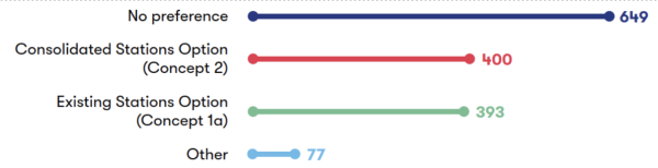
Figure 5-1: Numerical breakdown of responses to question 7a
A total of 1,519 respondents responded to this question. Just over half (52%) of respondents expressed a preference for one of the options, with an almost equal split between the Existing Stations Option (26%) and the Consolidated Stations Option (26%). Meanwhile, just under half (43%) expressed ‘No preference,’ whilst 5% indicated ‘Other’.
We also provided respondents with the opportunity to provide comments about this proposal; these are summarised in the table below.
|
Sub-theme |
Feedback summary |
|
Preference |
Respondents expressed a range of views on the proposed station concepts. A large number of respondents favoured consolidating into four new stations (the Consolidated Stations Option, referred to as Concept 2 in the Technical Report) to improve journey times. Many of the respondents who supported retaining all nine existing stations (the Existing Stations Option, referred to as Concept 1a in the Technical Report) highlighted that it would maintain local connectivity. It was also suggested that retaining existing stations could reduce disruption, accelerate delivery, and lower costs. Some respondents raised concerns about the potential impacts of both options, including increased noise, vibration, and community severance. Suggestions included retaining Bow Brickhill station under the Consolidated Stations Option due to its proximity to employment areas and planned developments, ensuring that the relocation of Woburn Sands station serves new communities, and considering a hybrid approach (previously referred to as Concept 1b in the Technical Report). The hybrid approach would combine elements of both proposals, classifying stations as major, medium, or minor to support different service levels while retaining all existing stations. The need for improved reliability, faster delivery timelines, and better integration with local transport plans was also highlighted. A peak-only service was also proposed by a few respondents as an alternative option to both the Existing Stations Option and Consolidated Stations Option. Regardless of which concept is chosen, respondents also emphasised the importance of aligning the chosen option with future housing and infrastructure developments, such as the proposed Universal resort. |
|
Existing Stations Option (referred to as Concept 1a in the Technical Report) - General feedback |
A few respondents commented that the current service has been underutilised due to disruptions and suggested that improved reliability and connectivity could boost usage. They also suggested that retaining existing stations could support future housing developments, community cohesion and population growth whilst providing an accessible and sustainable travel option. Many respondents put emphasis on the historical and industrial significance of the Marston Vale Line stations. Other comments highlighted the importance of the stations such as Bow Brickhill, Fenny Stratford, and Millbrook to members of local communities without alternative transport options. Several respondents had a preference for retaining existing stations because they noted it could allow for quicker and cheaper implementation of the route, with less disruption to local communities, commuters, and road traffic. Some respondents questioned how viable maintaining all nine existing stations would be, citing the current underutilisation of stations, such as Kempston Hardwick and Bow Brickhill, and a broader lack of adequate facilities. Additionally, some respondents felt that the close proximity of some stations may lead to longer journey times and limit the opportunities for freight services. One respondent felt that retaining small stations as part of the Existing Stations Option could limit the line's potential to contribute to national strategies and suggested that fewer stations acting as hubs would be more effective, favouring the Consolidated Stations Option. |
|
Existing Stations Option (referred to as Concept 1a in the Technical Report) - Station access and facilities |
A small number of respondents raised concerns about the potential loss of local services, and one respondent highlighted the shift towards park-and-ride models if stations were relocated. Some respondents emphasised the need to retain existing stations to provide convenience and support the growth of areas such as Marston Moretaine and Bow Brickhill. They also noted the importance of maintaining stations like Kempston Hardwick and Fenny Stratford, which are within walking or cycling distance for many residents. These stations were seen as vital to encouraging sustainable travel and reducing car dependency for commuters. Some respondents raised suggestions for enhancing station services under the Existing Stations Option, including improved car parks at stations and improved service reliability considering current issues with cancellations and limited timetables. They also highlighted the need for adequate staffing at stations to ensure passenger safety and facilitate ticket sales. There were also calls to improve access to stations, with a few respondents raising suggestions for better integration with the Milton Keynes Redway system, provide secure and sufficient bicycle storage, and ensure adequate parking at stations such as Stewartby, Woburn Sands, Millbrook, and Kempston Hardwick to prevent overspill parking on surrounding roads. |
|
Existing Stations Option (referred to as Concept 1a in the Technical Report) - Traffic and connectivity |
Many respondents expressed support for retaining the stations, citing the continued convenience it would offer to residents. They raised the strategic value of the Marston Vale Line, noting that it provides a direct commuter link to fast services at Bletchley and Bedford, connecting to Central London and the North. They noted that the Marston Vale Line is regularly used for commuting, shopping, and education, and emphasised the importance of keeping stations close to settlements to support connectivity and sustainable travel. Some respondents expressed concern that maintaining too many stations could slow down services and limit freight capacity. Additional concerns were raised about potential road congestion and queuing at level crossings due to frequent train movements. To address these concerns, some respondents suggested ways to improve service efficiency while retaining existing stations. This included increasing train speeds and introducing limited-stop services, where only selected trains call at every station, this was noted as an alternative way to speed up journey times whilst balancing local connectivity. |
|
Existing Stations Option (referred to as Concept 1a in the Technical Report) - Cost |
One respondent felt that the stations proposed for decommissioning are currently underused and do not warrant the investment required for their retention or improvement. However, one respondent mentioned that passenger demand may have been underestimated. They saw the Existing Stations Option as a more cost-effective alternative, avoiding the expense of constructing new stations and allowing investment to be focussed on the new Bedford to Cambridge railway. A few respondents felt that the Existing Stations Option could reduce the scale of construction works, lowering overall project costs and minimising disruption to the surrounding countryside compared to the Consolidated Stations Option. Specific reference was made to Ridgmont station, where respondents suggested that its retention could lead to savings in maintenance and operational costs, particularly if the associated level crossing could be closed. |
|
Existing Stations Option (referred to as Concept 1a in the Technical Report) - Environmental impacts |
Some respondents felt that retaining existing stations could help reduce reliance on cars, thereby lowering air pollution and encouraging walking and cycling as low-carbon transport options. Some respondents highlighted the environmental benefits of maintaining access to stations such as Woburn Sands, Bletchley, and Bedford, which support more sustainable travel choices. Additionally, many respondents emphasised the historical significance of existing station buildings and called for their preservation as part of the area's heritage unless a clear case for redevelopment is made. |
|
Existing Stations Option (referred to as Concept 1a in the Technical Report) - Local economy |
While a few respondents expressed concerns about the potential economic implications of the Existing Stations Option, a few others emphasised the importance of keeping all existing stations open to support local services and sustain long-term investment in the area. In particular, the expected the Fenny Stratford station would positively contribute to the local community and made suggestions for additional station features for improved access to education, employment, and daily travel. Additionally, retaining existing stations was seen as essential to supporting the future viability and growth of areas such as Milton Keynes. |
|
Existing Stations Option (referred to as Concept 1a in the Technical Report) - Land impacts |
One respondent was concerned that widening platforms under this option could intrude on gardens, driveways, and properties on Bye Road. They also noted that Bye Road is narrow and raised worries about overspill parking if stations do not have sufficient parking. One respondent also suggested building on existing structures for extra parking facilities to minimise land disturbance. |
|
Consolidated Stations Option (referred to as Concept 2 in the Technical Report) - General feedback |
A large number of respondents who supported the Consolidated Stations Option cited benefits such as faster and more reliable services providing better direct access to city centres, improved station facilities, and better alignment with future housing and population growth. Many also recognised the operational advantages of fewer stops, such as reduced service conflicts and shorter journey times. A few respondents supported relocating specific stations, including Woburn Sands and Ridgmont, to address current capacity issues. A small number of respondents also noted the need to future-proof stations to enhance the railway’s overall efficiency and appeal. They recommended measures such as strategically selecting station locations and ensuring that the new stations can accommodate potential increases in demand from developments like the proposed Universal resort. Some respondents suggested retaining stations like Bow Brickhill, Fenny Stratford, and Aspley Guise due to their proximity to homes, schools, workplaces, and local businesses. Several respondents also felt that the low demand figures presented were a result of unreliable and infrequent services. There were also calls to include Bow Brickhill in the Consolidated Stations Option and to not retain Lidlington station. While some saw the Consolidated Stations Option as a reasonable compromise between local access and strategic connectivity, they emphasised that it must be supported by strong mitigation measures including a clear plan to manage and assess the viability of redundant station buildings if closures proceed. Many respondents expressed concern about the potential reduction in the number of stations, with many emphasising the importance of retaining existing stations to ensure access for all, particularly those without alternative transport options. |
|
Consolidated Stations Option (referred to as Concept 2 in the Technical Report) - Station access and facilities |
Some felt that consolidated stations could potentially serve as travel hubs by delivering operational benefits and upgraded facilities. However, several respondents stressed the importance of ensuring accessibility and facilities to support travel to and from stations since the new consolidated stations would be out of walking range for many. This included suggestions for free or low-cost parking, electric vehicle charging and enhanced pedestrian and cycling infrastructure. Some respondents also suggested integrating stations with reliable bus services to connect rural communities to the new stations. Further proposals included a road bypass in Lidlington and a direct footpath from a relocated Stewartby station to Kimberley College. Some respondents suggested that stations should be designed to accommodate longer trains, flat access from trains, electrification, more space for parking and passing loops to enable more frequent services. One respondent called for stations to include shops and cafés. |
|
Consolidated Stations Option (referred to as Concept 2 in the Technical Report) - Traffic and connectivity |
Many respondents acknowledged that reducing the number of stops on the Marston Vale Line could shorten journey times and improve service efficiency, particularly for travel between key destinations such as Oxford and Cambridge. One respondent highlighted that the Consolidated Stations Option could better integrate with planned developments, including the Marston Valley and South Caldecotte areas. In contrast, several respondents raised concerns about the potential increased reliance on cars, and several were also concerned about reduced connectivity if local stations were closed. Some respondents felt that this could lead to higher traffic volumes, congestion, and parking pressures around consolidated stations. Some also commented that they would be less likely to use the service if their nearest station required driving, citing increased costs such as fuel and parking. There were specific concerns about the closure of the Millbrook, Aspley Guise, Bow Brickhill, and Fenny Stratford stations which are within walking distance of local communities and were perceived as well-used for travel to schools, and jobs. Some respondents suggested the provision of dedicated walking and cycling routes to the new stations and highlighted the current lack of sufficient infrastructure to support these modes of travel. Some respondents also put emphasis on the need for reliable and frequent bus services to connect communities to the new stations, particularly for vulnerable groups who may find it difficult to travel longer distances. Specific infrastructure improvements were also proposed, including the construction of a traffic bridge at Woburn Sands to manage increased vehicle flow, and a new access road in Lidlington to ease congestion on Station Road. There were also concerns about the impact of station closures on local communities under the Consolidated Stations Option and respondents requested more detailed information on public transport alternatives to help mitigate potential congestion from increased car use. |
|
Consolidated Stations Option (referred to as Concept 2 in the Technical Report) - Cost |
A large number of respondents supported the Consolidated Stations Option, highlighting its potential for financial efficiency, faster services, and better economies of scale. They suggested that consolidating stations could reduce the burden on taxpayers, enable a more streamlined and efficient train service, and deliver higher-quality facilities at fewer, modern stations. Some respondents also noted that newer stations are generally easier and more cost-effective to maintain, and that this option could reduce both costs and land use at Stewartby. However, a small number of respondents raised concerns about the cost of closing existing stations and constructing new ones. The proposed new station at Woburn Sands was specifically mentioned, with one respondent arguing that its cost could exceed its potential usage. One respondent felt that passenger demand may have been underestimated and the passenger demand was higher than EWR Co had predicted, suggesting that the Consolidated Stations Option would be a short-term, less sustainable solution. A few respondents expressed concern about the role of private funding in delivering new stations. One respondent commented that S106 tariff funds should be ringfenced for community infrastructure rather than station construction. |
|
Consolidated Stations Option (referred to as Concept 2 in the Technical Report) - Environmental impacts |
A small number of respondents raised several environmental concerns about relocation of stations under the Consolidated Stations Option. The risk of increased car usage and longer journey times were seen as undermining sustainable transport goals. One respondent also saw the closure of Bow Brickhill and Kempston Hardwick stations as detrimental to local sustainable transport plans. A few respondents commented that the location that was proposed for Lidlington station overlapped with land that was to be used for strategic planting. They raised that this planting would serve as a green buffer, separating Lidlington and new housing development. One respondent noted that this planting supports a 30% tree canopy requirement under the Local Plan, so East West Rail may need to compensate for its loss, potentially through contributions to the Forest of Marston Vale. Many respondents advocated for reusing existing infrastructure where possible, noting that this approach would help minimise environmental, wildlife, and societal impacts. Many supported the development of new stations, citing opportunities to avoid flood-prone areas and incorporate climate-resilient features such as Sustainable Drainage Systems and integrated water management solutions. A few respondents also raised concerns about the potential impact on Grade II listed station buildings, including Fenny Stratford station building, Railway Station House in Woburn Sands, Crossing House in Aspley Guise, and Millbrook station. This included calls from one respondent to ensure the redevelopment of Ridgmont station is sensitively designed to reflect its listed status and should contribute to the character of the Marston Valley area. Specific concerns were also raised by one respondent about the environmental impact of removing and replacing Woburn Sands station, particularly due to its location within the designated green corridor of the South East Milton Keynes Strategic Urban Extension. Additionally, one respondent called for the design of new stations to follow sustainable best practices, referencing Cambridge South station as a positive example. They emphasised that any new station proposals should meet high environmental standards, including targets for water efficiency and renewable energy generation. There were also recommendations for stations to achieve an excellent rating under the Building Research Establishment Environmental Assessment Method (BREEAM), ensuring long-term sustainability and environmental performance. |
|
Consolidated Stations Option (referred to as Concept 2 in the Technical Report) - Local economy |
A small number of respondents supported the Consolidated Stations Option, citing benefits such as modern, accessible station facilities, improved train connections, and reduced road traffic. A small number of respondents saw these improvements as opportunities to support strategic growth by better serving housing and employment growth, as well as boosting tourism especially if the proposed Universal resort is integrated into the route, for example through the development of a dedicated station. A few respondents also anticipated wider economic benefits, with one respondent highlighting a projected 5% increase in Gross Value Added compared to the Existing Stations Option. A few respondents also supported the consolidation of Stewartby station which they felt aligned with Bedford Borough Council’s growth objectives. The proposed relocation of Lidlington station was also welcomed, with a few respondents requesting it remains easily accessible to residents north of the station and meets the needs of planned development and increased demand. Some respondents felt that this option did not adequately account for the scale of commercial and residential development expected in the area nor the need for integration with local transport schemes. There were also concerns raised by a few respondents that closing stations along the Marston Vale Line could negatively affect economic growth in smaller communities across Bedfordshire, as well as impact local businesses and institutions such as the Open University. There were specific mentions of increasing passenger numbers at Bow Brickhill station due to its proximity to the Red Bull Technology Campus and proposed housing developments. Some respondents argued that removing train stops at this station could impact connectivity for young professionals, commuters, and school students, reducing the area’s attractiveness for business investment and long-term economic growth. A few respondents raised concerns about the proposed relocation of Aspley Guise station. Moving it east of the village was seen as likely to reduce access for local residents, with potential knock-on effects for the surrounding economy. |
|
Consolidated Stations Option (referred to as Concept 2 in the Technical Report) - Land impact |
A small number of respondents recognised potential benefits of the Consolidated Stations Option, particularly at Stewartby, where it could better align with future housing developments. There were concerns about the closure of stations such as Bow Brickhill and Kempston Hardwick, especially given their proximity to areas undergoing commercial and residential development. Many respondents felt that removing these stations could disrupt local growth and reduce connectivity for expanding communities. A few respondents raised concerns that works to close Millbrook station could impact nearby medieval cultivation earthworks and called for further engagement to explore how potential harm to historic assets could be avoided or mitigated. A few respondents raised concerns about the proposed new access road from Aspley Guise station to the consolidated Ridgmont station, particularly given that access would already be available via Bedford Road, south of M1 Junction 13. A few respondents noted that the road would serve only as a secondary route, yet it could be costly to construct and potentially disturb habitats, residential properties and protected land. |
5.3 Ridgmont station
The question we asked
We asked respondents to share their preference between Option 1 and Option 2, as well as giving them the choice to respond with ‘No preference’ or ‘Other’. The feedback we received to this question is shown in Figure 5-2.
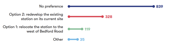
Figure 5-2: Numerical breakdown of responses to question 8a
A range of views were expressed about the proposed location of the station by 1,321 respondents, with the majority (63%) expressing no preference. A quarter (25%) were in favour of rebuilding the station on the current site (Option 2). Out of the remaining respondents, 9% opted for its relocation west of the M1 (Option 1), whilst 3% indicated ‘Other’.
We also provided respondents with the opportunity to provide comments about this proposal; these are summarised in the table below.
|
Sub-theme |
Feedback summary |
|
Preference |
Respondents expressed a range of views regarding proposals for Ridgmont station under the Consolidated Stations Option (Concept 2). While some supported upgrades to the existing station (Option 2), others highlighted the importance of preserving the heritage centre and tearoom. Some respondents raised doubts that passenger demand would increase enough to justify a new facility or upgrades. A range of alternative suggestions were also raised including a hybrid approach which would retain the current station alongside the development of a new interchange facility in Husborne Crawley. Further proposals included expanding the Bedford-bound platform at the existing site or rebuilding the station nearby. Respondents noted that any upgrade or relocation should be coordinated with the Bedford–Milton Keynes Waterway scheme to ensure alignment with broader regional plans. It was also suggested that local authorities should play a role in selecting an option to help minimise disruption to the surrounding landscape. Additionally, there was emphasis on the need to ensure the provision of safe cycling infrastructure and good connectivity to the station. |
|
Option 1 - General feedback |
Respondents expressed a range of views regarding the proposal to relocate Ridgmont station to the west of Bedford Road (Option 1). Supporters of the relocation included several respondents who cited improved access, enhanced facilities, and opportunities for future development. This included potential integration with the Hayfield Park Villages site and the Aspley Guise triangle. Relocation was also seen as a way to improve rail journey efficiency, support economic growth, and align with wider transport initiatives. Several respondents expressed a preference for relocation to avoid disruption to local businesses. Some respondents who opposed the relocation cited concerns about the potential negative impact on sustainable commuting options. They felt that the existing station is well-positioned to serve its communities and should not be moved, whist a few questioned the cost-effectiveness and efficiency of relocation. It was also felt that Option 1 could render the existing station redundant and result in the continued operation of the Station Road level crossing. |
|
Option 1 - Traffic and connectivity |
A few respondents felt that relocating the station could better serve future housing and commercial developments, improve access from the M1, and deliver better sustainability outcomes, provided it is supported by appropriate infrastructure such as lighting, cycle paths, and public transport connections. Additional suggestions included providing high-quality walking and cycling infrastructure and ensuring that any platform extensions are future proofed. Other respondents raised concerns about the relocation, with some citing reduced access for pedestrians and cyclists, increased reliance on car travel, and the potential to discourage rail use among workers commuting to nearby industrial estates, including Prologis Park and the Amazon warehouses. A few also highlighted the challenges of crossing the busy M1 junction due to the lack of pavements on dual carriageways, which could deter active travel. The proximity of the proposed station to M1 Junction 13 also raised safety and capacity concerns from several respondents, with worries about potential traffic congestion impacts during construction. Mitigation suggestions included providing a publicly accessible footbridge as a crossing point and ensuring bus links to nearby areas such as Cranfield and Ampthill/Flitwick. A few respondents expressed concerns about the impact on the heritage centre at the existing station building, and the potential for urban severance due to the proposed station’s distance from the village and developed areas. To address these issues, respondents called for a masterplan to assess overall impacts on the road network and ensure the station’s integration with broader transport and development strategies. |
|
Option 1 - Environmental impacts |
One respondent acknowledged the potential positive effects of selecting Option 1 such as enabling the Ridgmont pumping station to proceed, supplementing water supplies by 2027, and supporting planned housing growth in the EWR corridor. A few respondents raised concerns about the environmental impact of relocating Ridgmont station to the west of Bedford Road, including the potential loss of green space and productive agricultural land, as well as broader concerns about harm to the countryside and land designated as green belt areas. One respondent also commented on the increased travel distances required to access rail services under this option, which they felt could contribute to an increased carbon footprint. One respondent expressed concern about the flood risks associated with the proposed access road and intrusion on areas designated for environmental mitigation. A few respondents also put emphasis on the heritage value of the Grade II listed station building. One respondent suggested that options for retaining the building should be explored and suggested that financial commitments for its maintenance should be clarified. |
|
Option 2 - General feedback |
Respondents shared a range of views on the proposal to redevelop the existing Ridgmont station on its current site (Option 2). Several respondents supported this option as a more cost-effective and less disruptive approach. A few respondents emphasised the importance of integrating the station with active travel links, with others highlighting its role as a community hub, and preserving its connection to nearby employment sites. A few respondents felt that keeping the station in its current location would support sustainable commuting and help reduce car dependency. Some respondents also felt that relocating the station could disrupt established commuting patterns, reduce usage, and increase reliance on car travel. However, a few respondents raised concerns about the potential impact on local businesses, including the possible closure of premises and the cost of compulsory acquisition orders. |
|
Option 2 - Traffic and connectivity |
Several respondents who supported Option 2 felt that the current site is well-used by commuters, helping to reduce reliance on car travel. A few respondents also noted the station’s proximity to the M1 motorway and major roads such as the A421 and A507 as a strength, offering good road connectivity. Some respondents felt that the current location would provide the best connectivity for nearby residents, as well as access for pedestrians and cyclists, in alignment with EWR’s objectives to promote active travel and door-to-door connectivity. However, one respondent raised concerns about limited pedestrian infrastructure and the distance from Aspley Guise, which could affect access for some users. Respondents also stressed the need for suitable mitigation where public rights of way may be disrupted and supported the provision of an accessible footbridge. One respondent supported the footbridge as it would follow both the waterway and railway, enhancing pedestrian access. A few respondents raised concerns about the potential for increased traffic congestion at M1 Junction 13. A few respondents objected to the scale of proposals at the site, particularly the addition of car parking on both sides of Station Road and the closure of the railway crossing, which could create a cul-de-sac and increase local traffic. They requested minimising new developments in the open countryside considering the potential traffic increases expected from nearby developments such as new housing, warehouses, and the proposed Universal resort. Respondents also highlighted the need for improved traffic management in the area surrounding Ridgmont. A few respondents raised concerns about the long-term viability of bus links and questioned whether they would be maintained over time. To improve capacity and support freight operations, passing loops at Ridgmont were suggested by one respondent. One respondent proposed extending platforms at Ridgmont station to accommodate longer trains and another proposed developing a compact freight terminal to serve nearby warehouses. |
|
Option 2 - Environmental impacts |
Some respondents supported Option 2 for environmental reasons. A few respondents felt that redeveloping the existing station would avoid the need to build on greenfield land, reduce environmental impact, and help preserve the station’s heritage architecture. A small number of respondents highlighted reusing existing infrastructure as a positive step, helping to limit land disturbance and make use of brownfield land instead of open countryside. The proposed closure of the Station Road level crossing was viewed by some as a way to reduce earthworks and improve visibility between the railway and the nearby waterway. The planned footbridge was also welcomed for maintaining access across both. A few respondents raised concerns including the area’s high surface water flood risk, the age of the existing buildings, and whether the site could support future expansion. One respondent felt that keeping the station in its current location might limit the potential to create a modern interchange. One respondent raised concerns that Option 2 could prevent the delivery of a key water main upgrade to Milton Keynes, which could delay housing development and affect water supply in the area. More broadly, a small number of respondents raised concerns about the environmental and health impacts of upgrading the existing station including more uncertainty and pollution which could impact the wellbeing of residents. To help reduce emissions during construction, respondents suggested using engineered timber to lower the embodied carbon of station infrastructure. |
5.4 Stewartby station
The question we asked
We asked respondents to share their preference between Option 1 and Option 2, as well as giving the choice to respond with ‘No preference’ or ‘Other’. The feedback we received to this question is shown in Figure 5-3.
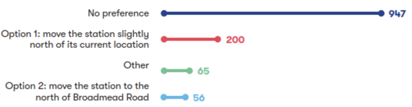
Figure 5-3: Numerical breakdown of responses to question 9a
A range of views were expressed about the proposed location of the station by 1,268 respondents, with three quarters (75%) expressing no preference for any option whilst 16% of respondents were in favour of Option 1. Only 4% of respondents preferred Option 2 whilst 5% of respondents indicated ‘Other’.
We also provided respondents with the opportunity to provide comments about this proposal; these are summarised in the table below.
|
Sub-theme |
Feedback summary |
|
Preference |
Respondents expressed a range of views regarding the proposed relocation of Stewartby station under the Consolidated Stations Option (Concept 2). Some respondents opposed relocating the station entirely, citing its current access for Kimberley College students, existing usage levels, and concerns about inconvenience if moved. One respondent also raised concerns about whether sufficient evidence had been provided to justify relocation and calls for further analysis and consultation. Many respondents supported Option 1, which involves relocating the station slightly north, based on its closer proximity to the village and Kimberley College. In contrast, some respondents favoured Option 2, which would relocate the station north of Broadmead Road, because they believe it better aligns with potential future developments. The importance of improving active travel routes, regardless of which option is taken, was also highlighted by a few respondents alongside calls to ensure that local community needs are fully considered in the decision-making process. Some of the respondents who expressed no preference for the location of Stewartby station further commented support for whichever option would lead to faster completion. |
|
Universal resort |
Many respondents highlighted the potential impact of the proposed Universal resort near Stewartby on the project, particularly in relation to the location and design of Stewartby and Kempston Hardwick stations. A large number of concerns about the absence of detailed consideration for the proposed Universal resort within the current proposals. One respondent recommended early engagement with Universal to ensure that railway infrastructure is aligned with the park’s operational and visitor needs. It was also suggested that station locations should be optimised to support access to the resort, with a large number of respondents proposing a new station between Stewartby and Kempston Hardwick to serve both the park and surrounding developments. Option 2, which involves relocating Stewartby station north of Broadmead Road, was viewed by a few respondents as better positioned to support tourist access to the park. Many respondents preferred retaining Kempston Hardwick station or combining it with a new facility designed to serve the resort. Suggestions included integrating the station with the resort’s site, designing facilities to accommodate high passenger volumes, and exploring options such as shuttle services or parkway-style stations. Some respondents suggested a southern route could better serve the resort and Wixams, citing potential cost and environmental benefits. Concerns were also raised about the consultation process, with calls for further assessment of the resort’s impact and its integration into the EWR plans. |
|
Option 1 - General feedback |
Respondents expressed a range of views regarding the proposed relocation of Stewartby station slightly north of its current location (Option 1). Some respondents who supported Option 1, noted its potential to serve the Stewartby Brickworks site, facilitate the redevelopment of brownfield land, and enable future infrastructure improvements, such as replacing the level crossing with a bridge. A few respondents also raised the limited development potential of the current station site due to its proximity to nearby lakes. While some respondents felt that Option 1 may have less ecological impact compared to Option 2, a few respondents were concerned about potential operational challenges at Rookery South Pit, the loss of green space, and broader environmental impacts. While some respondents noted that Option 1 could support future developments, such as the proposed Universal resort, several respondents expressed a preference for minimising the relocation distance to reduce disruption and maintain convenience for current users. One respondent also recommended revisiting station usage data to inform decision-making. One respondent also raised concerns about the potential impact of a proposed third platform at Stewartby station on barrier down times at Green Lane and Broadmead Road level crossings. The wider effects on the local area, including parking and footpath upgrades near Stewartby Lake were also highlighted by a few respondents. Alternative suggestions included redeveloping land near the waste incinerator or retaining the existing station as a commuter or metro-style facility without a third platform. Additionally, some comments suggested that moving the station away from the level crossing could reduce costs and support the future construction of a bridge. |
|
Option 1 - Traffic and connectivity |
Several respondents noted that the slight relocation under Option 1 could preserve walking access for local residents and students. Several respondents argued that this location would better serve Stewartby village, Kimberley College, and the Marston Vale Millennium Country Park. Some suggested that Option 1 could improve access to proposed new housing developments and the Stewartby Brickworks site. In contrast, a few respondents expressed concern that Option 1 might reduce the amount of housing that could be delivered on allocated land and may not best serve the Kempston Hardwick Brickworks site. The need for improved walking routes from surrounding villages, sufficient parking provision, and continued access to the nature reserve and existing village, was also highlighted by a several respondents. Further suggestions included direct footpath links to the college, retention of access from the old brickworks entrance, and provision for walking and cycling access to the new station. There were also calls for sufficient underpasses and overbridges during both construction and operation of EWR to manage traffic impacts near the station. |
|
Option 2 - General feedback |
Respondents shared a range of views on the proposal to relocate Stewartby station to the north of Broadmead Road (Option 2). Several supporters of Option 2 highlighted its potential benefits, including improved access for tourists visiting the proposed Universal resort, alignment with the Bedford Borough Council’s Kempston Hardwick settlement proposal, and its strategic location between new housing developments and the A421, in line with the growth plan set out in Bedford Borough Council’s Local Plan 2040. A few respondents indicated that Option 2 was preferred in terms of sustainability because the station would be located centrally and would be easy to access by residents or visitors to the proposed Universal resort. One respondent noted that the relocation could enhance pedestrian and cyclist access from Wootton village, particularly with infrastructure upgrades. Additionally, some respondents felt that Option 2 could minimise disruption versus option 1 to neighbouring land users. |
|
Option 2 - Traffic and connectivity |
Some respondents felt that the proposed location under Option 2 would increase the distance by foot between Stewartby station and key destinations such as Kimberley College, Stewartby village, and Marston Vale Country Park. A few respondents suggested that this could lead to greater reliance on car travel, reducing connectivity for those without access to a vehicle, including older residents. While a few respondents acknowledged that Option 2 could offer improved connectivity for new residents and tourists, they emphasised the importance of integrating sustainable travel solutions. A few respondents also highlighted the need to manage potential increases in traffic and to ensure the station remains accessible to existing residents. To help mitigate the impacts of Option 2, a few respondents suggested providing a footbridge if the level crossing is closed, developing sustainable travel arrangements to support safe walking and cycling access, and ensuring the station is centrally located to serve both new housing developments and the existing village. |
5.5 New stations at Woburn Sands and Lidlington
|
Sub-theme |
Feedback summary |
|
Woburn Sands - General feedback |
Several respondents supported relocating the station to better serve new housing and employment developments, particularly if the new site included substantial parking facilities. There were also suggestions to construct a footbridge at the new station to improve access for residents south of the railway. Several other respondents felt that the station serves a key role in the community and noted that its current location is within walking distance, with suggestions that it should be retained in its current location. Respondents felt that any changes should be developed in collaboration with the local authority, with a focus on managing traffic and ensuring safe, accessible routes for pedestrians. Proposals included extending the proposed new foot path alongside the railway behind Hutton Way and Swallowfield School and reinstating a previously proposed pedestrian crossing in the area. |
|
Lidlington - General feedback |
A few respondents welcomed the proposed relocation of the station, seeing it as an opportunity to modernise the station’s facilities and better serve the local area. Further comments from a few respondents suggested retaining the existing station, mentioning that it is well-situated and meets the needs of the village. Concerns were raised about the potential loss of housing and buildings as a result of the proposed relocation. A small number of respondents felt that relocating the station could cause traffic issues, expressing particular concerns about Station Road and Church Street in Lidlington, which are already congested with on-street parking. One respondent felt that the proposed site could conflict with land allocated for housing in the Marston Valley development, as well as areas set aside for strategic planting between Lidlington and new villages in Marston Vale. They highlighted the importance of the planting in contributing to the Local Plan’s target of 30% tree canopy cover and felt that the relocated station could undermine this goal. |
5.6 Marston Vale Line level crossings
|
Sub-theme |
Feedback summary |
|
General feedback
|
Many respondents raised the importance of safety at level crossings, including strong support for features such as CCTV, lighting, locking barriers, and emergency contact systems, especially where crossings are retained. Many respondents believed all level crossings should be closed, with some referencing Network Rail’s 2010 commitment to close or upgrade all level crossings. This included concerns that the proposals were not in alignment with Network Rail’s proposals. Several respondents raised concerns about emergency vehicle access, particularly in relation to level crossing closures, with calls for accurate traffic modelling and engagement with ambulance services. Where crossings are proposed to be retained, several respondents suggested using improved signalling equipment to reduce barrier closure times and reduce traffic congestion and community severance. Many respondents emphasised the importance of maintaining active travel access considering expected increases in traffic and infrastructure changes, particularly where crossings link to schools, workplaces, and community facilities. Some respondents expressed a preference for inclusive, cycle-friendly infrastructure and noted the need to provide adequate replacements before footpaths and level crossings are closed. A few respondents also suggested that diversions involving busy roads without pavements be reviewed. Respondents raised environmental concerns about some of the proposed level crossing closures and suggested alternative mitigations, particularly where routes hold historical or functional significance. There were requests for further consideration around the impact of level crossing proposals on housing growth, industrial expansion, and other projects like the proposed Universal resort. A large number of respondents preferred grade-separated solutions such as bridges and underpasses to support safe and continuous access for all users and avoid future disruption. Many respondents also called for integrated, forward-looking approaches that support active travel aspirations and local strategies. |
|
Fenny Stratford (Simpson Road) level crossing |
Many respondents supported the proposal to retain the Fenny Stratford (Simpson Road) level crossing as a CCTV-monitored crossing, with widening to accommodate twin tracking. A few respondents highlighted the crossing’s importance for maintaining local traffic flow, supporting businesses, and providing essential access for residents. It was also seen as a key link to the Caldecotte Project, nearby parkland, and commercial units. However, many respondents opposed the retention of the crossing, citing safety concerns such as the risk of accidents, traffic delays, and doubts about the reliability of CCTV systems. These concerns were echoed by a small number of respondents who felt that the crossing posed a long-term safety risk to both road users and pedestrians. In addition to safety concerns, many respondents felt that closure could lead to increased traffic on surrounding residential roads, create a physical divide within the community, and disrupt local routes. These impacts were seen as particularly significant for vulnerable road users and those relying on consistent access to local services. Some respondents suggested mitigation measures such as enhancing the crossing’s safety features, installation of full barriers, emergency telephones, loudspeakers, and improved lighting. Others recommended alternative infrastructure solutions, such as constructing a road underpass, a new bridge for road users and pedestrians, a dedicated, foot and cycle bridge, or diverting traffic to the Watling Street overbridge. Respondents requested that EWR Co minimise wait times at the crossing and to ensure that pedestrian access to platforms remains available when the crossing is closed. A few respondents also stressed the importance of carefully considering local traffic patterns and the broader impact on surrounding roads and communities. |
|
Bow Brickhill (V10 Brickhill Street) level crossing |
Many respondents supported the retention of Bow Brickhill level crossing, a small number of whom cited its role in managing traffic flow and addressing safety concerns. Several respondents also expressed support for the construction of a new road bridge, in the event the crossing could not be retained, to reduce congestion that may arise from anticipated housing and employment growth in the area. Several other respondents opposed a new bridge and expressed concern about potential impacts such as increased noise and air pollution, visual intrusion, and disruption during construction. There were also worries raised by a few respondents that a new bridge could have adverse effects on local residents’ businesses, and the surrounding environment because the road is increasingly being used as access to the A5 and a new road bridge would encourage this activity. A few respondents raised concerns about the impact of the new road bridge, on the Red Bull Technology Campus, including the potential loss of parking and operational challenges. A few respondents highlighted further concerns about the potential impact of a new bridge on property values and the local highway network. A few respondents suggested closing the road and level crossing entirely instead, turning it into a dead end and rerouting traffic via the A5 or other existing routes. Some respondents suggested additional mitigation if a new bridge is required, such as adequate clearance for electrification of freight and embankments to minimise the need for structural reinforcement. A few respondents suggested relocating the Up platform at Bow Brickhill station to the east of the existing level crossing if the crossing is closed. Respondents suggested a range of mitigation measures, should the level crossing be retained, including reducing the speed limit for road traffic, constructing a Redway to ensure pedestrian and cyclist access, and using alternative retaining structures to reduce land take. Some respondents also suggested relocating the bridge further east to help prevent potential traffic, should the level crossing be retained. |
|
Browns Wood level crossing |
Many respondents supported the proposal to close the Browns Wood level crossing and divert users to Pony level crossing, citing benefits such as improved connectivity, safety, and economic growth. However, a few respondents highlighted the importance of ensuring that the Pony level crossing is suitable. Other respondents felt that the closure would intrude on public rights of way, access to green spaces, and community links. A few respondents proposed upgrading and retaining the crossing and one respondent suggested upgrading the crossing to a miniature stop light system. Another respondent suggested that EWR Co retain both Browns Wood and Pony level crossing in line with the South East Milton Keynes Strategic Urban Extension plans. There were also suggestions to obtain developer contributions to fund a pedestrian and cycle overbridge. One respondent emphasised the need to align any changes with government policies on active travel and to preserve access to Bow Brickhill station and other local amenities. |
|
Pony level crossing |
Many respondents supported the proposals to retain and upgrade the Pony level crossing, with a few respondents highlighting its importance as a bridleway and its growing relevance due to future housing developments. A few respondents thought this upgrade would enhance safety and accessibility, particularly for equestrians and pedestrians, and suggested additional features such as CCTV, emergency phones, lighting, and loudspeakers. There was also emphasis on the need for safe, uninterrupted journeys for all users and some respondents suggested integrating the crossing with future developments and active travel routes, such as walking links to new or existing stations. A small number of respondents noted safety concerns about the current crossing, including the steepness of the steps. They suggested closing the crossing entirely and replacing it with a bridge or underpass with improved visibility and safer design. Further comments called for improved accessibility for those with limited mobility, including the installation of ramps or a roofed bridge. One respondent suggested using developer contributions to fund a foot, cycle, or bridlepath overbridge. |
|
Woodley’s Farm level crossing |
Many respondents supported the proposal to close Woodley’s Farm level crossing and extinguish crossing rights. However, a few respondents also called for firm commitments to alternative infrastructure, such as a replacement bridge. Some respondents opposed the closure, with a small number of respondents raising concerns about the impact on public rights of way, active travel routes, and access to green spaces. There were also a small number of concerns about the loss of connectivity and increased inconvenience for local residents. Alternative suggestions included retaining the crossing for pedestrians with improved safety measures, such as a stop light system, or constructing a footbridge or underpass if closure proceeds. Respondents also stressed the need to prevent unauthorised crossings elsewhere if the route is closed. To address potential traffic impacts, a small number of respondents opposed closing the crossing and proposed creating passing places along the track instead or upgrading it to a road to improve access for new and existing residents. Additionally, one respondent requested track maintenance to support construction traffic if the route is used during development. |
|
Fisherman's Path level crossing |
Respondents expressed mixed views on the proposal to close Fisherman’s Path level crossing and divert users to Woburn Sands level crossing. Some respondents supported the closure, provided that suitable alternative routes are established, such as a footbridge at the relocated Woburn Sands station, to minimise diversion lengths. However, the proposed diversion via Drayhorse Crescent was criticised by one respondent for being circuitous, with its approximate 1km length considered significant by some. Some respondents opposed the closure, citing concerns about the impact on public rights of way, accessibility, and alignment with active travel policies. Several respondents suggested retaining the crossing with upgraded safety measures or providing alternatives such as an overbridge or underpass. One respondent also emphasised the need for well-lit, direct paths from Bow Brickhill Road to the alternative crossing. While some acknowledged that fewer crossings could improve railway safety and efficiency, they stressed the importance of maintaining convenient and accessible routes for all users. |
|
Woburn Sands (Newport Road / Station Road) level crossing |
Many respondents supported the retention of the crossing due to its essential role in maintaining community connectivity and access to key services. Several opposed retaining it, citing concerns about increased train frequency leading to traffic congestion, safety risks, and the potential for community division. Several respondents raised concerns about the potential for gridlock and traffic delays in Woburn Sands due to increased barrier down times. These risks were seen as being worsened by the current narrow footpaths and the lack of safe pedestrian crossings, particularly for school children. One respondent also raised concerns about the potential impact on local businesses and emergency response times. To address these challenges, respondents proposed a range of design solutions. Some respondents proposed replacing the level crossing with a road bridge or underpass and installing a pedestrian footbridge to ensure safe access for schoolchildren and other users. Some respondents proposed other suggestions, such as widening the footpaths to improve pedestrian and cycling safety, upgrading the barriers including installing them with the CCTV and emergency phone lines and night lights and a loudspeaker so those who monitor the line can issue warnings to improve safety and to reduce downtime and improve traffic flow, and creating a bypass and traffic diversions to ease congestion. One respondent requested that when the barrier is closed, pedestrian access should still be allowed to platforms. One respondent put emphasis on the need for detailed analysis and close collaboration with the local authority to explore viable alternatives and ensure that any final proposal meets the needs of the community. |
|
Mill Farm level crossing |
Respondents expressed a range of views on the proposal to close Mill Farm level crossing and divert users to Woburn Sands level crossing via existing footpaths. Many respondents supported the closure, citing safety and economic benefits, provided that the diversion was well-designed and accessible. However, some respondents opposed the proposal, highlighting the value of the public rights of way network and the crossing’s importance for active and sustainable travel, countryside access, and connectivity for pedestrians and cyclists. A few respondents raised concerns about the proposed diversion, which was considered significantly longer. The recent loss of Woburn Sands Footpath 3 (School Crossing) was also seen as a loss of convenient access by a few respondents. In response, a small number of respondents suggested retaining the crossing with enhanced safety features, such as miniature stop lights or CCTV. A few respondents proposed constructing a footbridge or underpass to maintain access for non-motorised users. |
|
Sewage Farm level crossing |
Several respondents supported the proposal to close Sewage Farm level crossing and divert the footpath. A few cited safety and economic benefits, and one respondent welcomed the provision of alternative routes. However, some respondents opposed the closure, emphasising the importance of preserving public rights of way and maintaining access to the countryside for walking and outdoor recreation. Some respondents suggested retaining the crossing for pedestrian use, with a few respondents proposing enhanced safety measures such as miniature stop lights. This included one respondent who argued that safety risks are reduced when crossings are responsibly and correctly used. A few respondents proposed extending the dead-end section of Apsley Guise Footpath 13 to Cranfield Road via a footbridge or underpass or diverting the footpath parallel to the railway towards an upgraded Mill Farm crossing. A small number of respondents also called for a footbridge to maintain strategic sustainable links to align with future development plans in the area. |
|
Aspley Guise (Station Road) level crossing |
Many respondents supported the proposal to retain Aspley Guise (Station Road) level crossing as a CCTV-monitored crossing, recognising its importance for village traffic, access to the north, and as a vital alternative route during emergencies or when other crossings are unavailable. One respondent questioned the reliability of CCTV systems, and a few highlighted the risk of increased traffic congestion due to longer barrier downtimes. Some respondents opposed the proposal altogether. A small number of respondents advocated for closure and replacement with a pedestrian bridge to address both safety and traffic concerns. A few respondents highlighted that the rise in train frequency was likely to worsen congestion, especially along Station Road and Salford Road, which are already difficult to navigate. A few respondents also stressed the need to maintain pedestrian access to platforms and suggested enhancements to the CCTV system, including emergency phone lines, night lighting, and loudspeakers for safety announcements. One respondent referenced Network Rail’s 2010 commitment to close or upgrade all level crossings for safety improvements, expressing concern that the current proposal may not align with that undertaking. |
|
Old Manor Farm level crossing |
Respondents generally supported the proposal to close Old Manor Farm level crossing and divert users to the Aspley Guise level crossing, with a few citing safety and economic benefits. One respondent suggested that the new access track north of the railway should be formally designated as a bridleway or public right of way to ensure long-term connectivity. However, some respondents opposed the closure, advocating for the crossing to be retained and upgraded if necessary and emphasised the importance of keeping it open for pedestrian and farm access and maintaining the public rights of way network to support usability and local connectivity. One respondent suggested installing CCTV for improved safety, another proposed creating a footpath alongside the railway from Berry Lane to the level crossing, and a further respondent requested a pedestrian link to Shelford Road via London Road before any closure takes place. One respondent also proposed replacing the embankment at Shelford Road with a roundabout or implementing a light-controlled or footpath crossing. One respondent highlighted the need to prevent unauthorised crossings and to ensure that any changes do not inconvenience users. While a small number of respondents supported the closure on safety grounds, one stressed the importance of reviewing actual safety risks rather than assuming danger. |
|
Berry Lane level crossing |
Several respondents supported the proposal to close Berry Lane level crossing and divert users via roads and access tracks to Aspley Guise level crossing, with a small number of respondents citing safety improvements and the operational benefits of reducing the number of crossings for faster and safer rail services. However, some respondents opposed the closure, expressing concerns that it would disrupt the public rights of way network, reduce access to the countryside, and discourage active travel due to longer routes to the proposed Ridgmont station. Environmental and cost concerns were also raised by a small number of respondents regarding the construction of new roads or tracks across open countryside. A few respondents suggested retaining the crossing with upgraded safety features, such as miniature stop light systems, underpasses, or accommodation bridges for pedestrians. One respondent argued that keeping the crossing open would help prevent unauthorised crossings elsewhere and maintain fair and convenient movement for local users. A small number of respondents emphasised that alternative access must be provided to preserve connectivity and minimise disruption. |
|
Long Leys level crossing |
Some respondents supported the proposal to close Long Leys level crossing and divert users to Aspley Guise level crossing via Berry Lane and proposed new access tracks. One respondent viewed the closure as a way to improve safety and efficiency, whilst another highlighted potential economic benefits. One respondent felt the crossing should only be closed if access to Berry Lane from the eastern side is guaranteed, especially if Ridgmont station remains in its current location. Several respondents opposed the closure and advocated for the crossing to be retained and upgraded if necessary. A small number of respondents emphasised the importance of keeping footpaths open and one respondent proposed alternatives such as an underpass or bridge for pedestrians. A few respondents also stressed the need to maintain access to the countryside and to prevent unauthorised crossings elsewhere if the route is closed. |
|
Husborne Crawley Footpath 6 level crossing |
Many respondents supported the proposal to close Husborne Crawley Footpath 6 level crossing, provided that suitable alternative routes, such as footbridges or safe pedestrian pathways designed to accommodate mobility aids and pushchairs, were implemented. A few respondents were concerned that the closure could negatively impact accessibility, public rights of way, and active and sustainable travel. A few respondents felt that the proposed 750 metre diversion along Bedford Road would be challenging, as the road lacks a footpath, is frequently used by heavy goods vehicles, and one respondent believed it would require a safe pedestrian walkway to be considered suitable. One respondent suggested retaining and upgrading the crossing for safety, ensuring any new infrastructure does not inconvenience users. Another recommended consulting with the Local Highway Authority to provide a footpath along Bedford Road to connect with existing footpaths. Additionally, one respondent emphasised the importance of maintaining countryside access and preventing unauthorised crossings elsewhere. |
|
Matey Boys level crossing |
Some respondents supported the proposal to close Matey Boys level crossing and extinguish crossing rights. This included a few respondents who cited that closure would reduce the safety risks posed by the level crossing. One respondent also highlighted the benefits of the closure for improving train movements and removing delays due to barrier downtimes. Another respondent highlighted that the Bedford Road could serve as an alternative route when this level crossing is closed. A few respondents emphasised the importance of maintaining public rights of way and encouraging walking and outdoor exercise. One respondent highlighted the importance of supporting government policies on active and sustainable travel, whilst another respondent highlighted the potential for increased unauthorised crossings if the route were closed. A few respondents suggested retaining the crossing with upgraded safety features, such as miniature stop lights, or constructing an underpass or bridge to maintain pedestrian access, whilst a small number stressed the need to ensure that any changes do not inconvenience users or reduce connectivity. |
|
Husborne Crawley Footpath 10 level crossing |
Respondents expressed a range of views on the proposal to close Husborne Crawley Footpath 10 level crossing and divert users to Ridgmont level crossing or the station footbridge via a public footway along Mill Road. Several respondents supported the closure, with a few respondents noting safety improvements, economic benefits, and the potential for faster and safer rail operations. A few respondents supported the proposal if alternative crossings or footbridges are provided nearby for convenient access. However, one respondent suggested that the crossing should be retained and upgraded for safety, including the installation of a miniature stop light system. There was also a suggestion from one respondent for alternative routes, such as creating a new path from Station Road along the western boundary of the M1 to the original crossing point. Another respondent proposed diverting the footpath to run along the south side of the Marston Vale line between just west of the M1 overbridge and Ridgmont station or using land alongside the M1 to exit the path at Mill Road near the bridge. |
|
Ridgmont (Station Road) level crossing |
Respondents expressed a range views on the proposal to retain or close Ridgmont (Station Road) level crossing, depending on the future location of Ridgmont station. Several respondents supported closing the crossing if the station remains in its current location (Option 2), with a small number of respondents citing safety concerns of Option 1, the availability of an alternative road route via the A507, and the opportunity to remove design constraints on the adjacent waterway. In contrast, a few respondents felt that closing the crossing would reduce public access, hinder active and sustainable travel, and limit access to the countryside. They emphasised the need for suitable alternatives if the crossing is closed, such as a footbridge, underpass, or other accessible solutions for pedestrians, cyclists, and disabled users. Several respondents were in favour of retaining the crossing if the station is relocated (Option 1) and one respondent preferred retaining the crossing as a CCTV-monitored crossing. Additional concerns were raised by a small number of respondents about the potential impact on local traffic and access to the heritage centre at the existing station site. |
|
Broughton End level crossing |
Many respondents supported the proposal to close Broughton End level crossing and divert users to the Playing Field level crossing via existing footpaths. A small number of respondents supported the proposal provided that alternative access such as a footbridge or an upgraded Playing Field crossing is provided. A small number of other respondents agreed with the closure on the grounds of economic benefit, improved safety, and more efficient rail operations, particularly where alternative crossings were nearby. One respondent raised concerns about the crossing’s location at the intersection of multiple paths, noting its importance as a key link for walkers. One respondent raised that there is no direct public right of way to the Playing Field level crossing from the north due to a ditch and the absence of a public right of way across the sports field. The proposed diversion was criticised by a few respondents for forcing walkers onto roads without verges, limiting access to the countryside, and conflicting with government policies on active and sustainable travel. One respondent suggested retaining the crossing and upgrading its safety features if necessary. A small number of respondents proposed installing either a footbridge or an underpass. One respondent suggested installing miniature stop light crossing, whilst a small number of respondents proposed diverting users to Forty Steps instead of the Playing Field crossing. |
|
Forty Steps level crossing |
Respondents expressed a range of views on the proposal to close Forty Steps level crossing and divert users to the Playing Field level crossing via existing and new footpaths. Some respondents supported the closure. A few respondents said they would support the proposal provided that alternative routes or safety improvements such as footbridges or underpasses were provided. Several respondents opposed the closure, with a small number highlighting Forty Steps level crossing as a safe and well-used route. One respondent highlighted that the crossing provides access to the countryside and forms part of the Greensand Ridge and local public rights of way network, and a few respondents suggested to retain the Forty Steps level crossing to preserve countryside access for both new and existing residents. One respondent also emphasised the need for a north-south connection over the railway, particularly in light of the planned development of 5,000 homes in the Marston Vale area. Further concerns were raised by a few respondents about the impact on accessibility and disruption to local communities. One respondent highlighted the absence of a direct right of way on the north side of the crossing, which would force pedestrians onto roads without footpaths or verges. |
|
Playing Field level crossing |
Many respondents supported retaining and upgrading the Playing Field level crossing to a miniature stop light crossing. A few respondents highlighted its importance for access to the playing fields and the school, as the nearest crossing point to the village on the western side. One respondent was concerned that its removal could divert walkers onto roads without verges and limit safe access to footpaths on the opposite side of the railway. One respondent noted that upgrading the crossing could help maximise line speed and increase rail traffic frequency. However, some respondents opposed its retention, with one respondent citing general safety concerns around level crossings, particularly those without locking barriers. One respondent referenced Network Rail’s 2010 commitment to close or upgrade all level crossings and felt the current proposal fell short of that promise. A small number of respondents raised alternative suggestions including diverting the footpath, replacing the crossing with a precast underpass, or building a new bridge for vehicles, cyclists, and pedestrians. Additional safety features such as CCTV, an emergency phone line, night lighting, and a loudspeaker were also proposed by one respondent. One respondent stressed the need for a joined-up approach with wider strategies, such as the public rights of way strategy for Marston Valley. |
|
Lidlington (Station Road) level crossing |
Respondents shared a range of views on the proposal to retain Lidlington (Station Road) as a CCTV-monitored crossing. Many respondents supported its retention, with a few emphasising its role in maintaining village connectivity and access to key services such as schools, shops, and sports facilities. A small number of respondents raised concerns that closing the crossing could divide the village and increase journey times for emergency vehicles. A few respondents suggested retaining the crossing with full barriers, instead of automatic half barriers. A few respondents were concerned that retaining the crossing and increasing barrier downtimes due to more frequent trains could lead to congestion, safety risks, and misuse of the crossing. They raised alternative suggestions including constructing a new road bridge or underpass, a pedestrian footbridge, or a rail bypass around the village. One respondent proposed additional safety features including emergency phone lines, night lighting and loudspeakers, and a further respondent proposed installing time indicators showing expected barrier downtimes. |
|
Piling Farm South level crossing |
Several respondents supported the proposal to close Pilling Farm South level crossing and divert the footpath to Station Road or via the proposed Lidlington station footbridge. They anticipated benefits including improved safety and greater efficiency. However, some respondents opposed the closure, raising concerns about accessibility and the impact on active travel. A small number of respondents highlighted that the crossing is an important link for walking routes to Marston Moretaine and for connecting trails such as the Marston Vale Trail and the John Bunyan Trail. A few respondents suggested retaining the crossing with improved safety features and access to well-used footpaths nearby, such as those leading to Marston Church. A few respondents proposed alternatives such as a footbridge, underpass, or accommodation bridge to maintain access. One respondent suggested converting the crossing to a full barrier system, a further respondent proposed installing miniature stop lights, and another requested any footbridge involves minimal diversion. |
|
Marston (Marston Road) level crossing |
Respondents expressed a range of views on the proposal to either close Marston Road level crossing and construct an overbridge or upgrade it to a full barrier crossing. Several respondents opposed Network Rail’s assumed closure of the crossing, and some highlighted its importance as a key route for local traffic. A few respondents raised concerns about the potential impact of its closure on village connectivity, and one respondent raised concern for the impact on the environment, including the loss of woodland, disruption to wildlife habitats, as well as the visual impact of a proposed overbridge. Further comments from a small number of respondents supported upgrading the crossing to a full barrier system, viewing it as a more cost-effective solution. There was emphasis on maintaining connectivity, public rights of way and ensuring sufficient clearance for full electrification and freight services. Suggestions included minimising land use, ensuring a link road between Station Road and Marston Road is in place before overbridge construction, and avoiding prolonged closures during the works. Several respondents expressed preference for the closure of the level crossing and construction of a new overbridge, citing improved safety and the need to accommodate growing road and rail traffic. |
|
Millbrook (Station Lane) level crossing |
Respondents expressed varied views on the proposal to retain Millbrook (Station Lane) level crossing as a CCTV-monitored crossing. Many respondents supported retaining the level crossing. They emphasised its role in providing local connectivity including access to employment, education, healthcare, and local businesses. A small number of respondents also noted its role in reducing car dependency and the associated environmental impacts and felt that retaining the crossing could help deter high traffic volumes from using unsuitable local roads. A few respondents raised concerns about potential traffic congestion and safety risks due to increased train activity and longer barrier downtimes. Others opposed the proposal entirely, with one respondent citing doubts about the reliability of CCTV systems and another highlighting the general safety risks associated with level crossings. One respondent stressed the need to maintain pedestrian access to platforms if the crossing is closed. There was also a call to consider long-term development and connectivity in the area when making a final decision. |
|
Green Lane level crossing |
Respondents expressed varied views on the proposal to retain Green Lane level crossing as a CCTV-monitored crossing. Some supported retention, with one respondent requesting the crossing is modified to include full barriers and a further respondent requesting that it needs to take future development into account. A few respondents that the crossing was vital for local residents and requested proactive planning to avoid future disruption and unnecessary costs. Others stressed the importance of ensuring that the crossing does not hinder long-term rail development. However, some respondents opposed retention, with a small number citing current safety risks and traffic queues which could be worsened by traffic increases expected from future developments. One respondent raised concerns about the reliability of CCTV systems and the functionality of the level crossing. Some respondents proposed closing the level crossing and replacing it with a bridge or underpass to address safety and traffic concerns given the crossing’s role as a key access route. One respondent proposed retaining the crossing with upgrades, such as emergency phone lines, night lighting, and loudspeakers for issuing warnings. |
|
Stewartby Brickworks level crossing |
Respondents expressed a range of views on the proposal to close Stewartby Brickworks level crossing without replacement and to extinguish the footpath north and south of the railway. Some supported the closure, with a small number referencing the 2020 Transport and Works Act Order and planning permissions that include a new bridge as part of the site’s redevelopment. One respondent also noted that reducing the number of crossings could improve safety and operational efficiency. One respondent raised the level crossing’s role in providing access to schools and a small number of respondents raised concerns over the impact of the closure on active and sustainable travel. One respondent was concerned that its closure could impact connectivity including access to future housing and industrial developments. One respondent raised concerns over increased traffic in Stewartby, and a small number highlighted inconvenience caused by new transport arrangements and reduced access to the countryside. One respondent proposed retaining and upgrading the crossing with enhanced safety measures, a small number proposed providing a pedestrian overbridge or underpass as part of the project, and a few requested ensuring access through station infrastructure if a new station is built. A small number of respondents also stressed the need to consider the wider redevelopment of the brickworks site, and a few highlighted the potential for a new community that would require both a station and a safe crossing. |
|
Wootton Broadmead (Broadmead Road) level crossing |
Some respondents supported the proposal to retain Wootton Broadmead (Broadmead Road) level crossing as a CCTV-monitored crossing. One respondent requested the crossing is upgraded to a full barrier rather than an automatic half barrier. A few respondents raised concerns about barrier downtimes in both options for Stewartby station, which were noted to be up to 34 minutes per hour under Option 1 and 27 minutes per hour under Option 2. In response, some respondents suggested to close the crossing and replace it with a bridge or overpass to improve safety and traffic flow. They suggested that such replacements could accommodate expected increases in traffic from future developments such as the Stewartby and Kempston Hardwick Brickworks sites and the proposed Universal resort. A small number of respondents requested active travel links, such as footbridges or cycling infrastructure as well as inclusive access for equestrians, pedestrians, cyclists, including people using pushchairs, and mobility aids. |
|
Wotton Village level crossing |
Respondents expressed a range of views on the proposal to close Wootton Village level crossing and divert users to Kempston Hardwick crossing via new footpaths. Some respondents supported the closure and agreed with the proposed diversion, with a small number citing safety improvements and economic benefits. There were also concerns that the closure could negatively impact public rights of way, including some respondents that felt that the diversion was not suitable due to the traffic levels on Manor Road and the lack of footways along it. A small number of respondents suggested retaining and upgrading the crossing with enhanced safety features, such as a miniature stop light crossing. A few respondents suggested providing a bridge for pedestrians or an underpass. One respondent also emphasised the need for a safe and accessible route along Manor Road if it is closed. |
|
Kempston Hardwick (Manor Road) level crossing |
Respondents expressed a range of views on the assumed closure of Kempston Hardwick (Manor Road) level crossing and the proposed construction of a new overbridge. Some respondents supported the closure, with one suggesting it could enhance safety and potentially deliver economic benefits. A few respondents raised the importance of the crossing for local traffic and for workers accessing the nearby industrial area. One respondent suggested retaining and upgrading it to enhance convenience and safety instead. One respondent also raised concern about the anticipated barrier downtime of 34 minutes per hour, given the already busy Manor Road. There were also questions about the decision to retain the crossing if it is not closed, given proposals to increase the speed and frequency of trains. One respondent felt that this choice was inconsistent with previous decisions and not in alignment with Network Rail’s 2010 commitment to either close or upgrade all level crossings. |
|
Woburn Road level crossing |
Some respondents supported the assumed closure of Woburn Road level crossing and its replacement with a footbridge. A small number of respondents felt that could address current safety concerns, particularly for pedestrians, cyclists, older people, and disabled people. One respondent proposed easy-access ramps and a covering to improve cycle access. Another respondent raised the need for sufficient clearance for full electrification, including freight trains. A few respondents also called for a previously permitted bridge to be implemented or a new bridge suitable for vehicles, cyclists, and pedestrians to be provided. Across these views, there was emphasis on prioritising safety and ensuring alternative routes are available if the crossing is closed. In contrast, several respondents opposed the closure, stressing the importance of maintaining access for both vehicle and active travel users. One respondent proposed upgrading the existing crossing to a miniature stop light crossing with additional safety features such as CCTV, lighting, locking barriers, and a loudspeaker to deter misuse. A small number of respondents highlighted the need for cycle access, clear signage, and a phone link to the signaller. One respondent felt the proposed option was inconsistent with Network Rail’s 2010 commitment to close or upgrade all level crossings. |
5.7 Infrastructure features
|
Sub-theme |
Feedback summary |
|
Track layout between Ridgmont and Stewartby |
Several respondents highlighted the need for passing loops, particularly between Ridgmont and Stewartby, to enhance freight and passenger service capacity. It was noted that passing loops should be strategically located to avoid conflicts with station relocation plans and land designated for development. Respondents also suggested that bridge replacements and level crossings along the route should be assessed in collaboration with Network Rail to ensure suitability for increased train traffic. While several respondents were in support of twin-tracking the railway in this section, concerns were raised by one respondent about the environmental impact of twin-tracking, such as tree removal, with suggestions for replanting to mitigate this impact. Suggestions made by respondents included twin-tracking at the canal bridge near Fenny Stratford, retaining the station site at Ridgmont and considering Stewartby as a location for passing loops, and incorporating passing loops into station layouts to support freight services. |
5.8 Environment and sustainability
|
Sub-theme |
Feedback summary |
|
Air quality and emissions |
Several respondents supported the project for its potential to promote sustainable transport, reduce carbon emissions, and encourage more active lifestyles. The role of rail travel in supporting Net Zero goals was also highlighted by one respondent. However, a small number of concerns were raised about the potential for increased road journeys, particularly where station closures or relocations could lead to greater reliance on car travel. They described the project’s overall carbon footprint as disproportionate and questioned the environmental impact of constructing larger car parks, which were not viewed as a sustainable solution. Further comments suggested the creation of woodland or parkland to replace lost open space and closed public walking routes and to mitigate potential noise and air pollution. |
|
Operational noise and vibrations |
Several respondents raised concerns about the potential increase in operational noise and vibration resulting from the proposed changes to the railway. It was noted that current services, which are limited in frequency and speed, are relatively quiet. However, the proposed increase in train frequency and speed, along with the introduction of Sunday services, was expected to result in more noticeable noise and vibration impacts. A few respondents identified freight trains as a particular concern, especially during night-time hours, due to the current noise and vibrations they generate. The absence of detailed noise mitigation proposals within the consultation materials was highlighted, particularly in locations such as Lidlington, where residential properties are situated close to the railway. Respondents suggested that noise mitigation measures should be implemented on both sides of the track and that the potential impact of additional freight services, particularly at night, should be assessed and addressed. Specific areas of concern included Bye Road, Hurst Grove, and Station Road, as well as Swallowfield Lower School, where outdoor and classroom activities take place near the line. Further concerns were raised by a small number of respondents about the potential noise impact of a new road bridge at Bow Brickhill, particularly due to the increased height of the road and associated traffic noise. Some respondents suggested acoustic barriers and landscape mitigation to reduce the impact on nearby property values. The use of quieter rail track technology was suggested as another approach to mitigate noise impact of the project. |
|
Water resources and flood risk |
A few respondents raised concerns about the proposed balancing pond near the south-west edge of Caldecotte Lake, noting its location within the River Ouzel floodplain. It was suggested that this may be unsuitable unless the land is raised and appropriate floodplain compensation or expansion is provided elsewhere to maintain the floodplain’s capacity. There was a small number of respondents who were also concerned about potential flood risks to nearby residential areas due to the introduction of additional hard surfaces such as tarmac and concrete. More broadly, one respondent questioned the scale of the proposals, noting that up to 35 balancing ponds are planned along the Marston Vale Line. It was considered excessive for an existing railway and expressed concern that it could set a precedent for future rail infrastructure upgrades. Others urged the design of balancing ponds to align with ecological and landscape considerations. Alternative land use was also raised as a concern. A small number of respondents suggested that land near new station locations might be more appropriately used for station facilities rather than for balancing ponds. A few others noted that the proposed use of land for drainage infrastructure could limit opportunities for onsite ecological enhancements and flood attenuation measures required by Arqiva’s Outline Planning Application for warehouse and ancillary office development on their Kempston site. A few respondents also highlighted the complexity of delivering water infrastructure near Ridgmont station, particularly where it runs close to railway land and crosses Station Road near the level crossing. |
|
Biodiversity and nature conservation |
One respondent felt that Bye Road would be unsuitable for utility diversions due to its narrowness and proximity to sensitive woodland. They were concerned that this diversion could cause long-term environmental damage and requested more information about proposed restoration plans. Broader worries were raised by a few respondents about the potential damage that construction activities could cause to heavy clay soils. There were also concerns that using farmland for construction could result in the loss of benefits that have been gained through regenerative farming practices, such as soil quality, reduced compaction, preserved nutrients, and increased organic matter. A few respondents also raised concerns about the proximity of construction to wildlife habitats and the potential impact on Lidlington Cricket Club’s southern boundary. Suggestions included planting hedgerows and grassland to support habitat creation. One respondent also opposed the proposed secondary road from Apsley Guise due to anticipated habitat loss. A few concerns were raised about the placement of Biodiversity Net Gain areas along the Marston Vale Line, with requests for more information about the rationale for the selected areas and long-term funding plans. Some habitat creation sites were considered inaccessible or overlapping with enhancement works at other sites by a few respondents. Additional comments requested reduced land use at Marston Road level crossing to further protect woodland and habitats. A small number of respondents were concerned that high-voltage cables could be diverted through the Forest of Vale Millenium Country Park Wetlands Nature Reserve, which supports rare species such as the Eurasian Bittern and Marsh Harrier. The location of a proposed balancing pond in this area was also criticised by a few respondents for its potential impact on conservation habitats, with suggestions to use existing lakes for flood alleviation. Respondents proposed tree planting at several level crossings and closed stations and recommended that planning requirements include a target of 30% tree cover. They also encouraged collaboration with the Forest of Marston Vale to support Biodiversity Net Gain and its woodland cover target. Further comments urged EWR Co to thoroughly assess natural habitats and implement strong mitigation measures. |
|
Landscape and heritage |
A few respondents questioned the impact of proposals on the historical and heritage value of Ridgmont station and other nearby sites. The importance of preserving the Grade II listed station building, its heritage centre, and tea rooms was emphasised by a few respondents, with some concerns that relocation or demolition could harm its significance and tourism appeal. A few respondents raised concerns about the potential loss of medieval cultivation earthworks, ridge, and furrow features, and other archaeological remains recorded in the Central Bedfordshire and Luton Historic Environment Record. One respondent raised that some of these are linked to scheduled monuments, such as Thrupp End Moat, and could be affected by station relocations, passing loops, and other infrastructure works. The potential impact on the setting of other heritage sites, including Danesborough Camp and Stewartby Brickworks, was also highlighted, along with the need for further engagement and field evaluations. Several respondents also highlighted concerns about the impact of the project on sites such as the medieval settlement of Wood End and Roman road Viatores 225. A few respondents also noted that overhead power lines, bridges, and acoustic barriers could disturb the rural and historic character of the area. They called for assessments and mitigation measures to protect heritage assets, retain vegetation, and reduce visual disruption. This included suggestions to integrate the heritage centre and listed buildings into future railway plans. The importance of high-quality landscaping along the realigned road corridor was also noted, with calls for a strategic, landscape-scale approach to mitigation and Biodiversity Net Gain. |
5.9 Traffic and transport
|
Sub-theme |
Feedback summary |
|
Connectivity |
While many respondents acknowledged the potential connectivity benefits of the project, they emphasised that these should not come at the expense of local community cohesion and accessibility. Some respondents called for improved local bus services to support connectivity if stations or crossings are closed. They also emphasised the importance of ensuring new stations are accessible and well-connected to wider public transport networks to maximise connectivity. Further comments proposed a rail chord at Bletchley to improve operational flexibility and connectivity to the West Coast Main Line. |
|
Access to stations |
A few respondents were concerned that limited public transport in rural areas would make car travel necessary, potentially increasing congestion and delays. Additional concerns were expressed about the environmental impact of constructing larger car parks and relocating stations away from town centres, which could further increase reliance on cars to access stations. Several respondents raised that new stations should have ample parking, including provisions for park-and-ride facilities, to improve access. |
|
Active travel and public rights of way |
Some respondents highlighted the importance of maintaining public rights of way to support active travel and access to the countryside. They raised additional suggestions to accommodate active travel users including upgrading existing paths and creating parallel routes for walkers, cyclists, and horse riders. A small number of respondents saw proposals to close footpaths and level crossings as a barrier to active travel and community connectivity, with concerns that diversions could result in longer journeys and move users onto unsafe roads. One respondent also noted that new developments near the railway could increase demand for public rights of way, and suggested that proposals for new stations should include provisions for pedestrians and cyclists. |
|
Road journeys |
Many respondents raised concerns about the impact of the proposals on road traffic, particularly at level crossings such as Woburn Sands, where increased train frequency could lead to longer delays and significant congestion. Several respondents also raised the need for sufficient parking at stations, with concerns that commuters may choose to park on local streets to avoid charges, thereby worsening congestion in villages and towns. Safety risks associated with diversion routes were also highlighted by a small number of respondents, including the potential for increased traffic on unsuitable residential streets and unsafe driving behaviours. Some respondents suggested reviewing speed restrictions in residential areas to deter dangerous driving. To mitigate these effects, respondents suggested constructing bridges, providing bypass roads, or providing alternative routes around impacted areas. They also encouraged EWR Co to explore future proofing road infrastructure to accommodate expected increases in traffic from new housing developments. Finally, a few respondents requested that the rail upgrades do not negatively impact emergency response times or local transport options and that any changes are accompanied by detailed traffic management plans. |
|
Rail journeys |
Many respondents supported the inclusion of passing loops and twin tracking to enhance capacity, reliability, and future-proofing of the line. Installing passing loops at Forders Sidings, twin tracking at Fenny Stratford, and double tracking single-line sections were viewed as a means of minimising delays and improving service patterns. Further comments questioned whether the Fenny Stratford to Kempston route section would remain double track or be converted to single track. In relation to future-proofing, some respondents noted that anticipated developments, such as the proposed Universal resort and new housing, could significantly increase traffic congestion and cause delays at level crossings, particularly in areas like Stewartby, Kempston Hardwick, and Woburn Sands. As a result, some respondents suggested that crossings be replaced with bridges to accommodate future growth. A few respondents opposed the proposed reduction in line speed from 100 mph to 75 mph, arguing that it could undermine the economic value and appeal of the service. Views on service patterns were varied. While a small number of respondents advocated for express services between major centres, others supported the retention of stopping services to maintain connectivity for smaller stations. There were also questions about the impact of current services during construction. Respondents also asked if waste could be transported to Rookery South by rail via the proposed passing loop between Stewartby and Millbrook, as opposed to the current use of lorries. |
|
Freight |
A small number of respondents welcomed proposals for new passing loops as a means of increasing capacity and facilitating freight traffic, particularly at Ridgmont and Stewartby. Respondents noted that passing loops would support the integration of freight and express services, improve rail logistics, and enable frequent, fast train services across the railway. Additional comments asked whether electric freight trains would use the railway. Some respondents were concerned that the number of stations on the Marston Vale Line could limit the potential for frequent and fast services, including freight. Suggestions to address this included reducing the number of stations and implementing twin tracking to minimise delays and maximise usage. They also recommended ensuring a universal loading gauge to support network efficiency. Twin tracking at Fenny Stratford was also raised as a measure that could enhance freight capacity. A few respondents raised concerns about the impact of increased freight movements, particularly at night, highlighting issues such as noise, vibration, and disruption to residents in areas including Bye Road, Hurst Grove, and Station Road. The need to assess and mitigate these impacts, including the effect of additional barrier downtime, was emphasised. It was also suggested by one respondent that there should be sufficient capacity for 775 metre freight trains alongside passenger services, to accommodate the growth in deep-sea container shipping and wider efforts to decarbonise supply chains. |
|
Train services |
One respondent felt that the EWR route should be treated as a main line rather than a branch line. A small number of respondents suggested that there should be at least two trains per hour between Bletchley and Bedford, including a mix of express service and skip-stopping or alternating service patterns to balance speed and accessibility. The use of tram-train systems was also suggested to support local feeder services and hydrogen traction to reduce local particulate emissions. A small number of respondents made several suggestions regarding onboard facilities. These included reliable mobile and Wi-Fi coverage, and adequate cycle storage in carriages. The French Transport Express Régional network and the existing Marston Vale Line trains were cited as examples of good practice. Accessibility was also emphasised by one respondent, with calls for trains to be fully accessible for both pedestrians and wheeled users. Further comments suggested that facilities should be included at stations to support station adoption groups. To support affordability for residents, the introduction of a Residents Pass was proposed by one respondent to help prevent increased travel costs for short, local journeys. Concerns were also raised about the potential shift to driver-only operations, with some respondents suggesting that conductors should remain onboard to support ticketing and customer service. The proposal to introduce a Cambridge to Stewartby service was highlighted by a few respondents as a positive measure and one respondent commented that this service could reduce the need for additional platforms at Bedford station. |
5.10 Construction and logistics
|
Sub-theme |
Feedback summary |
|
Construction timeline and cost |
Several respondents expressed a preference for cost-effective and timely delivery of EWR. Some voiced frustration with the expected construction timeline and proposed opening the Bedford to Oxford service earlier, even if initially operating at reduced speeds. There was also emphasis on the importance of learning from past construction challenges, such as those experienced during the Bletchley viaduct project, to avoid delays and increased costs of delivery. Several respondents raised concerns about the financial and environmental impacts of constructing new roads or tracks, particularly through open countryside. A few respondents also raised concerns about the cost of relocating Stewartby station. The potential impact on housing delivery, and the need for stronger integration with local planning strategies was also highlighted. Many respondents emphasised the importance of integrating enhancements, such as passing loops and double tracking, into the initial design to avoid future disruption. Further suggestions to accelerate delivery included the use of a blockade to complete works faster, supported by a reliable replacement bus service during the closure. Several respondents called for swift action to deliver services between Bedford, Oxford, Aylesbury, and Cambridge, with some questioning the economic implications of further delays. |
|
Environmental impacts of construction |
A small number of respondents raised concerns about the potential environmental impacts of construction, including the loss of green spaces and floodplains, and increased pollution. They also raised the potential impacts of station parking and road infrastructure on areas of woodland, green space and public open space including walking routes. These issues were cited as potentially detrimental to local biodiversity and public access to recreational areas. A small number of respondents raised concerns about the social impacts of construction, including potential daily disruption from increased traffic, noise, dust, and vibration during the construction phase. These worries were noted to potentially impact areas near and including Bye Road, Hurst Grove, and Station Road in Lidlington. Respondents feared the proposed changes would result in intolerable noise levels, negatively affecting homes and quality of life. Additional feedback focused on the proposed haulage road adjacent to the Alexander Sports Centre field, where one respondent highlighted potential noise and visual impacts and requested mitigation measures, including physical screening, restricting operations to daylight hours, and implementing pollution controls. Some respondents also proposed rerouting the rail line to avoid nearby villages and called for enhanced noise reduction strategies to minimise disruption to residential areas. Some respondents emphasised the need to minimise environmental disruption, avoid unnecessary tree removal, and protect conservation areas. They called for careful planning to reduce landscape and traffic impacts while safeguarding environmental health and wildlife. Specific design suggestions included introducing steeper ramps for pedestrian bridges to reduce land take, avoiding unnecessary construction to protect habitats, and ensuring double tracking is delivered in a way that minimises environmental and traffic disruption. |
|
Traffic and diversions |
A few respondents raised concerns about the impact of construction traffic on existing congestion, particularly at the Woburn Sands level crossing and in areas where temporary traffic lights are proposed. Several roads, including Bury Ware in Lidlington and Lower Farm Road, were considered unsuitable for construction vehicles. A few respondents recommended the use of designated construction routes, such as Sheeptick End, Bedford Road, and the new road network into South East Milton Keynes Strategic Urban Extension, while avoiding Newport Road and Station Road. It was also suggested that unsuitable roads be redesignated with maximum weight restrictions to prevent inappropriate use. One respondent questioned the suitability of proposed diversion routes for equestrians and raised concerns about how the public rights of way network would be maintained during construction. The potential impact on local businesses during road closures was noted by a small number of respondents, along with concerns about the suitability of diversion routes such as Theydon Avenue. Respondents emphasised the importance of keeping local roads open where possible and minimising disruption, particularly in areas like Lidlington, due to its proximity to the railway, and the construction of a new road bridge. It was also noted that diversions could redirect vehicles onto narrow, one-way routes with on-street parking, potentially increasing delays. A small number of respondents noted the potential for construction activities to cause damage to local highways in areas such as Brogborough, Hulcote, and Salford. Considering existing financial pressures on Central Bedfordshire Council, it was suggested that EWR Co take responsibility for the maintenance and repair of any affected roads. A few respondents also raised the potential impact of construction on bus routes and requested timely communication of any changes, with some suggesting a minimum of three months’ notice. There were further calls for the use of haul roads to reduce reliance on public roads, enforcement of construction traffic rules, and agreed timetables to minimise disruption. |
|
Construction safety |
One respondent noted that some villages have narrow pavements and cars frequently parked along main thoroughfares, creating multiple hazards and making them unsuitable for increased HGV traffic. They suggested a measures to reduce a range of health, safety and well-being risks, including limiting works in public areas and restricting working hours to avoid evenings. |
|
Construction compounds |
A small number of respondents raised concerns about the location of proposed construction compounds and the potential impacts on surrounding areas and sought greater clarity on the rationale for selecting the proposed construction compound on Harworth’s Site. One respondent questioned whether alternative locations had been fully explored and suggested that the decision may have been informed by desktop analysis rather than a site visit. It was noted that the site no longer includes rail sidings, as may be suggested by older mapping sources. A few respondents also highlighted that the land has planning permission for dwellings and expressed concern that the compound could affect the delivery of homes and disrupt the phasing of the wider development. Similar concerns were raised by one respondent about the impact of the proposed compound on the former Stewartby Brickworks site, with suggestions to relocate it closer to commercial areas near Bow Brickhill. One respondent also questioned access arrangements for the proposed compound near Woburn Sands station and the associated utility construction zone. The respondent suggested relocating this compound closer to commercial areas to reduce disruption to residents. They also commented that temporary possession powers should not burden land for extended periods. One respondent requested further engagement to understand the compound and utility zone proposals, including access, operations, timescales, land take, and required infrastructure, to ensure coordination with future development plans. |
5.11 Community benefits and impact
|
Sub-theme |
Feedback summary |
|
Access to jobs, education, and healthcare |
Many respondents expressed support for the project, with many noting its potential to improve commuting options to key employment hubs such as Oxford, Cambridge, London, and Bedford. However, a small number of respondents raised concerns about the potential closure or relocation of stations and the resulting impact on access to jobs, education, and healthcare. Stations such as Aspley Guise, Woburn Sands, Bow Brickhill, and Millbrook/Marston were identified as vital links to schools, colleges, employment sites, and healthcare facilities. Many respondents highlighted the risk of increased travel times and the potential for villages to become disconnected from essential services if key stations and crossings are removed or altered. Pedestrian safety, particularly for schoolchildren, was raised as a priority issue, alongside the need for adequate lighting and safe access routes near stations. Several respondents raised concerns about station closures affecting individuals without alternative transport options. Specific issues were raised about the impact of construction on access to emergency services, doctors’ surgeries, and schools, as well as the potential disruption to local businesses and residents. Increased level crossing closures in areas such as Woburn Sands, Lidlington, and Stewartby were also highlighted, with a few respondents noting that these could restrict access to schools, shops, and healthcare facilities. |
|
Local economy |
Respondents noted that the project could support housing developments, the proposed Universal resort, and opportunities for education, employment, and leisure along the route. These benefits were seen as contributing to improved regional connectivity and economic growth. A small number of respondents also noted the potential for economic growth in areas such as Milton Keynes and Bletchley due to improved connectivity, citing examples of businesses like KPMG, PwC, and Aimii expanding or relocating to the region. A small number of respondents were concerned about the potential impacts of the project on local business operations, including the risk of closure or relocation. Specific concerns were raised about impacts on sites such as the Red Bull Technology Campus, Rookery South Limited’s Energy Recovery Facility, and Newton Trailers. There were also concerns about businesses located in Claydon House. Some respondents stressed the importance of maintaining access to key roads and crossings, such as the Fenny Stratford crossing and Simpson Road, and ensuring adequate parking to minimise disruption to businesses and residents. Further suggestions included establishing a support fund for businesses affected by construction and ensuring timely communication regarding road closures and diversions. A few respondents raised concerns about the impact of new housing developments on existing businesses, such as horse racing stables near Hulcote, and the need to balance growth with the preservation of established operations. |
|
Local communities |
Many respondents expressed concerns about the potential impact of the project on local communities, particularly in relation to the closure and relocation of rural stations. These stations were seen as vital for maintaining community connectivity, and there were concerns that relocating them could disadvantage existing residents while favouring newer, planned developments. Several respondents raised concerns about increased noise, vibration, and light pollution, especially for properties located close to the railway line. A few respondents requested mitigation measures such as acoustic fencing and the use of quiet rail track technology to reduce these effects. The anticipated rise in train and freight services, including operations at night and on Sundays, was also seen as a threat to the quiet character of the Marston Vale area and to residents’ overall quality of life. Some respondents felt that the closure of pedestrian crossings could prevent access to fields and walking routes, while others noted that increased barrier downtimes at level crossings could disrupt daily life for both pedestrians and drivers. Some respondents also raised concerns about the overall impact these changes could have on the well-being and cohesion of local communities. A few respondents raised particular concern about the proposed relocation of Stewartby station due to its potential impact on students attending Kimberley College, who currently benefit from a short and safe walking route. Similarly, the closure of Millbrook station was seen as limiting access to the Millennium Country Park, a valued local amenity. Some respondents raised concerns that increased rail traffic and station relocations could lead to community division, both physically and socially, and feared that their villages could become fragmented because of the project. To address this, suggestions included retaining stations at their current locations, redeveloping existing sites to minimise land use, and ensuring that any new stations are located close to residential areas. In addition, respondents called for greater consideration of the impact on local businesses, schools, and community facilities, and requested sufficient notice of any proposed changes. Some also questioned whether the EWR proposals would deliver sufficient benefits for existing residents. |
|
Safety and wellbeing |
One respondent raised safety risks around the possibility of people continuing to use closed crossings if adequate protection such as security fencing or barriers are not provided. Another respondent stressed the need for a coordinated approach to safety, including suggestions to construct pedestrian footbridges and replacement zebra crossings with stop-light-controlled alternatives to enhance pedestrian safety. Electrification infrastructure was also raised as a safety risk by one respondent, particularly where overhead lines may be located close to residential properties. One respondent raised further worries about antisocial behaviour on a pedestrian footbridge over the Marston Vale line where motorbikes and scooters could pose risks to pedestrians and rail safety. They requested EWR Co to consider physical design changes, such as steps or staggered gates, during future line expansion to deter such behaviour, while ensuring accessibility. Concerns were raised by a small number of respondents about the security implications of new roads providing easier access to private properties, with suggestions from some respondents to implement gated access on open roads and ensure safe, well-integrated connections between new infrastructure and existing road networks. A small number of respondents also highlighted the possible impacts of the project on stress and wellbeing, particularly among people facing compulsory land acquisition, demolition of their property, or prolonged construction near their homes. To help support safety and wellbeing, a small number of respondents proposed additional mitigation measures, including the installation of double or triple glazing in affected homes and the provision of secure, CCTV-monitored lockers at stations to deter bike theft. |
|
Impact on equality and protected characteristics |
A few respondents raised concerns about the lack of parking at stations such as Stewartby, Millbrook, and Kempston Hardwick and highlighted this a barrier to access, particularly for those with limited mobility. Many respondents saw the closure of stations along the Marston Vale Line, including Fenny Stratford and Bow Brickhill, as a risk to community connectivity. A small number of respondents warned that such closures could increase isolation for elderly and disabled residents, forcing greater reliance on private vehicles or reducing mobility altogether. A few respondents also viewed consolidated stations as potentially inaccessible for those with limited mobility, prompting calls for inclusive design features such as step-free footbridges suitable for disabled people, those with pushchairs, and cyclists. The proposed relocation of Stewartby station was criticised by a few respondents for its potential negative impact on students attending Kimberley College, who currently benefit from a short and safe walking route to the station. Broader concerns were raised about pedestrian safety by a few respondents, particularly for schoolchildren, with suggestions for improved safety measures, wider footpaths, and better lighting near stations and crossings. Several respondents emphasised the importance of inclusive design to ensure that the proposals do not disadvantage residents with mobility challenges or disabilities. Maintaining community connectivity and avoiding the segregation of neighbourhoods were seen as essential. Additionally, a few respondents highlighted the need for safe, off-road access for horse riders. |
5.12 Land and property
|
Sub-theme |
Feedback summary |
|
Residential land and properties |
A few respondents were worried that properties near the proposed route could be at risk of structural damage due to increased train speeds and construction activities. A small number of respondents also expressed concern about the loss of privacy and reduced amenity for nearby residents. They requested further information on the proposals, including structural surveys to assess potential impacts on homes, and guarantees against damage. Suggestions to mitigate these effects included the introduction of conservation covenants on acquired land and a sufficient buffer between construction areas and residential properties. A few respondents raised concerns about the environmental impact of new roads, their proximity to homes, and their effect on local traffic and the surrounding environment. This included worries about the loss of parking spaces for residential properties and the broader disruption for both current and future residents. One respondent requested more information around compensation mechanisms, such as the Need to Sell scheme, and whether studies had been conducted to justify the environmental and financial costs of the project. |
|
Property values |
Some respondents highlighted the possible negative effects on property values, with a few raising concerns about the ability of homeowners to sell or remortgage their properties due to the project. A few respondents were worried about the installation of acoustic barriers, overhead lines, and associated infrastructure near residential areas, citing significant visual impacts and the risk of further devaluation. There were calls for the careful placement of these infrastructure features to minimise proximity to residential areas. There were also concerns from a small number of respondents about the use of land that could be valuable for to future development plans for environmental mitigation. |
|
Business land and properties |
A few respondents felt that the proposed land acquisition required for the project was unnecessary and lacked sufficient public interest to justify interference with private property rights. It was also felt that the disruption to businesses along Woburn Sands High Street could not be justified, with particular concern about the wellbeing impacts on business owners facing compulsory land acquisition and potential property demolitions. One respondent raised concerns about the Red Bull Technology Campus where respondents were worried about disruption to operations, business continuity, and long-term strategic value. One respondent noted that the consultation materials did not adequately address how compulsory land acquisition would affect the Campus or its future viability. One respondent raised concerns about the risk to future growth due to parking shortages and noted that the loss of both permanent and temporary parking spaces could reduce overall capacity by up to 23%. Other issues included the potential loss of public art, restricted access to the MK-7 building service yard, difficulties in relocating external plant equipment, and the removal of the Wellbeing Woodland without any proposed replacement. Respondents suggested exploring alternative land options for the project, such as using undeveloped land to the east of the site to avoid displacing businesses and impacting agricultural land. The impact on farming operations was also raised by a few respondents, including access issues for machinery and potential income loss due to land acquisition. To mitigate these effects, respondents proposed replacing farm crossings with dedicated farm bridges and introducing alternative access roads. |
|
Planned and future developments |
A small number of respondents highlighted that significant new housing developments in the Milton Keynes and Marston Vale areas alongside other residential projects could increase traffic levels and require better integration with EWR proposals. The proposed closure of the Browns Wood footpath was also a particular concern for a few respondents who raised that it serves as a green infrastructure link between Browns Wood and the South East Milton Keynes Strategic Urban Extension (SEMK). A few respondents raised concerns about the use of land allocated for housing or employment for EWR-related infrastructure, including construction compounds, balancing ponds, and habitat creation areas and noted that this could hinder the delivery of key housing projects, such as the SEMK development and the Marston Valley allocation. One respondent raised concerns that EWR proposals could conflict with local plans such as the MK City Plan 2050, with calls for better alignment to avoid obstructing strategic growth areas. There was further emphasis on the need for close collaboration between EWR and local authorities to ensure that the project supports, rather than hinders, planned development. Additional suggestions were made to refine road alignments, junction designs, and habitat creation plans to ensure compatibility with local housing and infrastructure projects. While some respondents suggested that land north of the railway should not be used for environmental mitigation due to its potential future development value, others proposed that EWR Co should exclude certain sites from safeguarding or enter early negotiations to acquire them to minimise financial losses. |
6. Bedford
This chapter presents feedback received on proposals for the Bedford section of the EWR route. This route section spans approximately 5.4 kilometres (3.4 miles), running north from Ampthill Road in Kempston to Clapham Road in Clapham village, next to the River Great Ouse. It includes proposals around South Bedford and Bedford St Johns, Major improvements at Bedford station and the laying of additional tracks north of Bedford.
A total of 1,145 responses were received about this route section.
Some responses in this section reflect views or interpretations that may not accurately reflect the proposals set out in the consultation. To understand the context behind the feedback presented, it may be useful to refer to Chapter 10 of the 2024 Consultation Document. The consultation document and other consultation materials are available on our website: eastwestrail.co.uk/consultation2024
6.1 General route section
|
Sub-theme |
Feedback summary |
|
Route alignment |
A few respondents supported the inclusion of Bedford station in the route, citing its potential for economic growth and improved connectivity. However, many respondents also felt that the route could cause major disruption in Bedford. This included concerns about environmental damage, the demolition of homes and the loss of green spaces and agricultural land. Many comments opposed the cost of the proposed route; the length of journey times and engineering challenges compared to alternative options. Concerns were also raised about the limited number of stations in this route section, while others felt the economic benefits of the proposals around Bedford are uncertain. Further worries included increased congestion, pollution, and the impact on the towns character. Many respondents advocated for alternative alignments, suggesting that other routes could be shorter, cheaper, flatter, and less environmentally damaging, particularly if they avoid floodplain viaducts. There were calls for a full re-evaluation, including consideration of a southern route. Some comments proposed a southern parkway station south of Bedford, aligned with the A421 corridor, to reduce town centre congestion and better serve new developments such as the proposed Universal resort. Several others recommended reviving the old Varsity Line as a potentially viable alternative. |
6.2 South Bedford and Bedford St Johns
|
Sub-theme |
Feedback summary |
|
Ampthill Road and Cauldwell Street realignments |
Several respondents were concerned about potential disruption and congestion during works to the Ampthill Road and Cauldwell Street bridges. They highlighted that both Ampthill Road and Cauldwell Street are already heavily congested, especially during peak times, and closures or diversions could exacerbate these issues, and potentially cause gridlock and delay emergency vehicle responses. Respondents also raised the risk of lengthy disruptions during construction impacting access to key locations like the hospital and discouraging visitors to the town. They raised that these access impacts could harm local businesses and the economy. A few respondents questioned the necessity of rebuilding Ampthill Road Bridge and suggested that alternative solutions should be explored to minimise disruption. They also requested that traffic flow is maintained as a priority if construction is to go ahead. Suggestions included providing alternative routes, such as temporary bridges or level crossings and lowering the railway tracks beneath the bridges instead of raising the road. |
|
Bedford St Johns station relocation |
Many respondents supported the need for a new Bedford St John’s station, highlighting that a new car park and facilities would provide long overdue capacity and quality improvements. There was also support for relocating Bedford St Johns station and redeveloping Bedford station to align with Bedford Borough Councils wider regeneration plans. Some respondents saw value in realigning Bedford St Johns station and its parking capacity to benefit the hospital and provide easier access for pedestrians. In contrast, a large number of respondents were worried that the new station would be hard to reach for hospital patients, staff, and visitors. Particular concerns were raised for those with mobility issues as the station would be on the other side of the tracks from the hospital, requiring them to use footbridges and lifts. Some also felt that the stations may not be easily accessible for residents in surrounding villages, potentially increasing reliance on car travel. They stressed the need for the new station to prioritise accessibility, sustainability, safety, and connectivity to Bedford Hospital, while also ensuring integration with wider transport networks. Several respondents further questioned the necessity and cost of relocating the station, given its proximity to the main Bedford station. They also questioned whether there is enough demand from for rail travel to the hospital. A range of alternative solutions were proposed, including suggestions to remove Bedford St Johns station from EWR proposals entirely or to use the land where the original St Johns station was instead. There were also suggestions to relocate the station to the south of Bedford instead, between the Thameslink and East Midlands Railway, which could also be used for sidings, a turnback facility for additional platforms near major arterial roads, or integration with Bedford station. |
|
Multi-storey car park |
Several respondents supported the construction of a new multi-storey car park, highlighting that increasing parking capacity could deliver potential benefits for Bedford Hospital. However, many also raised concerns that a car park shared between hospital and rail users could worsen existing parking shortages. Others were concerned that the proposed site could prevent hospital expansion plans. They emphasised the need to minimise disruption to the hospital and local businesses while ensuring there is capacity to meet both hospital and commuter needs during construction and operation. Suggestions were raised to maintain parking during construction such as making sure the multi-storey car park is fully operational before any existing parking is removed. There were also requests for the station design to support anticipated future demand. This included suggestions for a secure drop off and pick up area and electric vehicle charging points. Some respondents also suggested that free parking should be provided local NHS staff, similar to the car park at Britannia Road. A small number of respondents were worried that the multi-storey car park could cause more queuing within an already congested highway network. A few respondents opposed the construction of a multi-storey car park next to a train station arguing that it does not align with goals to encourage active travel and sustainable transport. There were also comments on the visual and environmental impact of the nine-storey structure with suggestions to explore underground or less visually intrusive options. Several respondents questioned how the multi-storey car park would be funded, with concerns that the cost might fall to Bedfordshire Hospitals NHS Foundation Trust or rely on uncertain private investment. They felt that these resources would be better directed toward essential healthcare services. |
|
Track layout |
Several respondents supported the construction of two additional tracks, viewing them as necessary to increase capacity, improve reliability and meet future demand. They also highlighted the broader benefits for rail operations, flexibility and connectivity. Some respondents questioned the need for additional tracks and suggested using modern signalling systems to make better use of existing tracks. They also suggested considering grade-separated junctions to reduce conflicts with other services. A phased approach to track expansion was also recommended. Additional suggestions included bidirectional running or adding an up-fast platform at Bedford station to reduce the need for additional tracks. |
|
Jowett and Cauldwell sidings |
A small number of respondents supported the relocation of Jowett Sidings to Cauldwell Walk, noting that this site avoids greenfield areas and concentrates activity near existing facilities. In contrast, several respondents commented on the environmental, community and economic impacts of relocating Jowett Sidings to Cauldwell Walk. Key concerns included the impact of the sidings on green spaces as well as potential rail traffic noise, air pollution and disruption near homes and businesses. To help reduce noise, they suggested limiting working hours to 8am to 6pm and moving the scrap metal facility. Some also asked that greenfield sites be avoided and focussing works near the existing Thameslink line. A few further felt that acquiring nearby industrial units would be necessary to support the project. One respondent opposed using parts of the Jowett Sidings site to stable shorter formation EWR trains, suggesting the land be repurposed for town centre development instead in line with Local Plans for 2030 and 2040. Others supported keeping the sidings and proposed adding a reversing siding near Bedford St Johns station to help with train movements or extending Cauldwell Walk northwards to avoid train reversals. There were also calls to maintain or improve capacity for Thameslink services and to ensure space for future EWR trains. |
6.3 Bedford station
|
Sub-theme |
Feedback summary |
|
Cost |
A few respondents were concerned about the cost of redeveloping Bedford station, arguing that passenger numbers might be falling because of the inflated cost of fares and unreliable services. |
|
Footbridges |
Respondents emphasised the need for accessible footbridges at Bedford station, with lifts and stairs included in the design. They also suggested making the new footbridges wider than the existing ones. Additionally, it was noted that the current lifts at Bedford station are often slow or out of use, therefore, the new lifts should be quicker, bigger, and could incorporate windows so people outside of the lifts can see if they are full. |
|
Local business impacts |
Several respondents recognised the potential community benefits of the project, suggesting it could raise Bedford's profile, attract people for work and leisure and improve access to other areas. Several others questioned whether this investment would address wider economic challenges in the town centre and asked for clearer evidence of the benefits of EWR for Bedford. One respondent suggested the line might encourage commuting to other towns rather than supporting local regeneration. |
|
Additional platforms and tracks |
Respondents expressed a range of views about the proposal for two new platforms and tracks at Bedford station. Several respondents supported the addition of two new tracks included one respondent noted related support for the extension of Platform 1A for Thameslink services. A substantial number of other respondents were concerned about the community impacts, including the potential demolition of homes, associated with the construction of new tracks and platforms. They suggested that existing infrastructure, particularly Platforms 1 and 1A, could accommodate the proposed EWR services without the need for additional platforms or tracks. Respondents were critical of the lack of an up fast platform in the proposals and felt that this limited EWRs alignment with Network Rail's Bedford Area Strategic Advice, published in 2022. Many argued that an up fast platform could improve connectivity with East Midlands Railway services, reduce congestion, and avoid the need for additional tracks. It was also felt that the absence of an up fast platform would require East Midlands Railway trains to change tracks, which could lead to potential delays |
|
Station services and facilities |
Many respondents supported the redevelopment of Bedford station and offered suggestion for features that could be incorporated into the design. These included a western entrance, improved cycle and pedestrian access, adequate parking space and bus connections. There were also suggestions to maximise interchange opportunities, including with long-distance services. Respondents noted improved access via the new public plaza. However, some respondents felt that the public plaza was concealed behind buildings and therefore would not create a significant visual improvement in the area. Further comments recommended adding amenities including a shop (such as a Sainsbury’s Local or M&S), a coffee shop, and improved toilet facilities. Some respondents raised the risk of years traffic and environmental disruption during construction. |
|
Multi-storey car park |
Several respondents raised concerns about the potential impacts of constructing multi-storey car park at Bedford station. They raised the risk of increased traffic congestion on Ashburnham Road and nearby streets, disruption to homes during the construction phase, and a potential increase in criminal and antisocial behaviour in the area. A few respondents also expressed concerns about the limited space available for parking near Bedford station, which would be necessary to accommodate growing passenger numbers, hospital visitors, and local commuters. They highlighted that the existing car park is already heavily used, so any new facility should provide extra capacity to operate effectively as a shared-use car park. However, a small number of respondents also raised concerns that a car park of sufficient size could negatively impact the area’s visual appeal. Some comments acknowledged the need for increased parking capacity but suggested alternative designs or locations that could help to minimise disruption. A few respondents also expressed concern the new car park might encourage car use over more sustainable travel options and take away from the character of the station environment. Further comments were received about the proposed temporary parking site, which some felt was too far from the station. Respondents requested more accessible temporary arrangements, particularly for people with mobility challenges, older passengers, and families with young children. Some respondents also saw opportunities to improve support for active travel. They suggested that the proposals could include indoor Dutch style cycle parking, with capacity to accommodate more bicycles than cars. |
6.4 North of Bedford
|
Sub-theme |
Feedback summary |
|
Track layout |
There was a range of views shared by respondents about the proposal to construct two additional tracks north of Bedford station to create a six-track corridor alongside the existing Midland Main Line. Several respondents supported the proposal and recognised the need for increased capacity, better service reliability, and the separation of EWR services from Midland Main Line traffic. However, they also emphasised the importance of accommodating future passenger and freight growth whilst minimising delays across the rail network. Several other respondents were concerned that the addition of the six tracks through Bedford station could require the demolition of homes and cause further noise, pollution, and congestion impacts. They highlighted the potential financial and social costs of using land currently occupied by existing homes for the project and rebuilding infrastructure such as Bromham Road bridge. Respondents called for transparency in modelling and evidence to justify the need for six tracks and urged for adequate compensation and mitigation measures for affected residents. They also called for mitigation measures for disruption to Hobson Park recreation area. Further comments suggested alternative proposals, including realigning fast lines, changing the route to avoid demolitions and implementing timetable-based capacity solutions to eliminate the need for tracks. There were also suggestions to use existing tracks with operational adjustments such as improved signalling and bidirectional running. |
|
River Great Ouse and Paula Radcliffe Way viaduct |
Several respondents supported the proposed viaduct over the River Great Ouse and Paula Radcliffe Way. This included a few who saw it as a solution to flooding in the area but emphasised the need for careful planning and mitigation measures. They particularly asked that noise and air quality mitigations are considered for nearby schools, nurseries, and care homes in the developing plans. They also suggested exploring ways to minimise traffic disruption and accessibility issues during construction, particularly on the A6, Paula Radcliffe Way, and Clapham Road. Many respondents were concerned that constructing on the floodplain could displace water leading to increased flooding in surrounding areas, and impact nearby properties and infrastructure. There were also worries that the structure could be visually unappealing and suggestions that it should be designed to integrate into the local landscape. |
|
Utility diversions |
Several respondents raised the risk of power outages and traffic light failures during utility diversions and emphasised the need to maintain power supply throughout works, particularly for critical facilities like hospitals. To minimise impacts on retained land and nearby residents, respondents urged early and active engagement with utility companies and Network Rail, to align with existing arrangements and agree on of the extent of utility diversions. They also suggested reconsidering the route in order to avoid utility diversions. |
|
Bromham Road bridge modifications |
It was noted that the recent upgrade of the bridge caused extensive traffic delays and inconvenience. Several respondents were concerned that works to modify the bridge for EWR could cause similar disruption including congestion and environmental impacts. They also questioned the visual impact of the bridge it’s impact on residential areas. Further comments that opposed the additional tracks north of Bromham Road bridge suggested that the existing four tracks could suffice if freight train frequency does not exceed four per hour. Respondents also recommended providing a pedestrian link between Spenser Road and Chaucer Road alongside exploring further design solutions to address safety concerns and allow access for pedestrians, cyclists, wheelchair users and buggies. This included considering routes that avoid people having to walk down Ashburnham Road from the proposed Bromham Bridge. |
6.5 Environment and sustainability
|
Sub-theme |
Feedback summary |
|
Air quality and emissions |
While a few respondents supported the potential long-term environmental benefits of moving road traffic onto railways, many were worried about potential increases in air pollution and emissions. This included several respondents who specifically opposed the use of diesel traction with a few arguing that it conflicts with sustainability goals and the UK’s carbon reduction commitments. Several respondents were also concerned that traffic disruption during construction could lead to increased pollution. Specific concerns were raised about the impact on Bromham Road and Midland Road. To minimise pollution and other environmental disruption, it was suggested that the plans should follow existing road infrastructure, such as the A421 corridor. One respondent felt that the proposed mitigation measures were insufficient for the level of works proposed in Bedford and called for air quality and energy use analysis. They also emphasised the need for engagement with affected individuals and institutions alongside agreed limits on environmental pollution. |
|
Operational noise and vibrations |
A few respondents were concerned about the increased noise from additional EWR and freight trains as they raised that existing noise levels from the Midland Main Line were already disruptive. They were worried that the proposed mitigation measures would not sufficiently address the increased noise and others called for commitment to reducing noise levels below current measurements. Additional concerns were raised by several respondents who felt that the construction and operation of viaducts, embankments, elevated tracks and diesel and freight trains would increase noise. Particular concerns were raised about noise impacts in densely populated areas, schools, nurseries, hospitals and wildlife habitats. A few respondents were also concerned that vibrations from passing trains might even affect property conditions and industrial processes, such as brewing. Respondents called for more effective noise and vibration mitigation strategies, including detailed noise contour mapping and early access to noise calculations. They also emphasised the need for fair compensation packages for affected residents. |
|
Water resources and flood risk |
Many respondents raised concerns about the proposed construction of a viaduct over the River Great Ouse floodplain and its potential to exacerbate existing flooding issues in Bedford and surrounding areas. It was also highlighted that the area already experiences frequent flooding, which has worsened in recent years due to climate change and increased development and changes in the use of this land over time. Several concerns were expressed about the displacement of floodwaters onto surrounding roads, homes, and businesses. Many respondents voiced their concerns for the potential for the viaduct's footings and foundations to disrupt the free flow of the river, alter the water table, and increase flood risks. Respondents questioned the adequacy of proposed flood mitigation measures, such as balancing ponds, and some called for a full Environmental Impact Assessment to identify any issues. They also raised the need for robust flood prevention and mitigation measures, including hydrological assessments and flood relief culverts to manage water flow effectively. Several concerns focused on the use of floodplains for construction including a few who commented on the strain on existing drainage systems, and a small number who were concerned with the potential flooding of heritage buildings and nature reserves. A range of alternative solutions were proposed to help manage flood risk. These included incorporating flood relief culverts into embankments to support water flow and raising sections of the railway on low concrete viaducts. Respondents also suggested using advanced drainage systems to manage increased rainfall and runoff. There were calls for collaboration with local councils to define clear flood risk parameters. Respondents also emphasised the importance of protecting aquifers and natural flood attenuation zones. Others recommended detailed technical assessments and independent reviews to better understand the potential impacts. In addition, there were suggestions to include water-saving features in the design of the new Bedford station, such as rainwater flushing systems. |
|
Biodiversity and nature conservation |
A few respondents raised concerns about the impact of the proposed viaduct over the River Great Ouse on biodiversity and wildlife. They emphasised the importance of the river as a Country Wildlife site and expressed concerns about the impact constructing the viaduct on the river’s associated habitats and species. Respondents called for greater clarity on the intentions for land use following construction and emphasised the importance of ecological improvements. They also encouraged collaboration with environmental organisations, particularly in relation to sensitive areas such as the River Great Ouse. Additional comments requested assurances around the preservation of mature trees, the creation of wildlife corridors and the swift replacement of flora lost during construction. There were also specific concerns for species such as bats, deer, foxes and badgers in the Bedford area. Respondents further highlighted the need for a 10% Biodiversity Net Gain to be delivered within the Project's boundary and not offset elsewhere. To support this, respondents requested a clear schedule of works that provides information on the types of environmental pre-tests and ongoing monitoring to be carried out, along with their timing. There were also suggestions for closer collaboration with local councils on construction codes and for proactive engagement with residents to help limit disruption. One respondent welcomed the opportunities for habitat creation and enhancement but called for more detailed plans to ensure effective implementation. This was considered particularly important for the viaduct, which was noted as having the potential to alter the character of the natural landscape. Other respondents raised suggestions including relocating sidings to brownfield sites such as Cauldwell Walk, creating a linear wildlife corridor alongside the cutting and golf course, and exploring the use of tunnelling to reduce landscape impacts. |
|
Landscape and heritage |
One respondent felt that the design of the proposed viaduct would complement the landscape of the river valley, in keeping with the tradition of many historic railway structures. However, concerns were raised about the eastern end of the viaduct, where it transitions onto a substantial embankment. It was suggested that this area, along with Clapham Green, present a valued stretch of amenity countryside which would benefit from carefully considered landscaping to help integrate the structure into its surroundings. One respondent supported the viaduct as a suitable solution for crossing the river but they expressed concern about the potential visual impact of overhead electrification infrastructure. To reduce this, there were calls to align electrification gantries with existing structures wherever possible. A few respondents also highlighted the potential loss of access to open spaces, community assets, and agricultural land. They emphasised the importance of protecting these areas for future generations. Suggestions were made to follow existing transport corridors, such as the A421, or to reuse and refurbish existing infrastructure, including St John’s station, to help minimise visual and environmental impacts. |
6.6 Traffic and transport
|
Sub-theme |
Feedback summary |
|
Connectivity |
A few respondents felt that the proposals lacked clarity on car parking, drop-off areas, and accessibility for people with mobility needs at the station. A small number of respondents further commented on the limited number of stations and the absence of a clear strategy for first–last mile connectivity. They also raised that public transport options were currently insufficient to support seamless onward travel. One respondent suggested that the proposed station entrance and parking arrangements could increase door-to-door journey times, particularly for rural communities that may continue to rely on car travel. Concerns were also raised about the potential isolation of communities due to road closures and the loss of access on routes like Spenser and Chaucer Roads. Respondents suggested ways to improve local access including the creation of a Bedford South or Parkway station and the provision of a platform at Bedford to accommodate faster services. Other comments focused on maintaining connections between communities by avoiding ‘dead ends’ and ensuring that areas such as Spenser Court are not used for vehicle turning. |
|
Access to stations |
Several respondents raised concerns about car access and parking at proposed station locations. It was noted by one respondent that access to Bedford station was already difficult for vehicles due to congestion in the town centre, particularly during peak periods. Respondents suggested that Bedford St. John’s could serve as Bedford’s primary station due to better access to South Bedford, Wixams, and the A421. Others proposed a parkway station to reduce dependency on Bedford station and improve access to North Bedfordshire. Respondents sought further information on plans to support bus and active travel routes to accommodate increased traffic and pedestrian flow around stations. They also suggested improving bus services, including upgrading bus interchange facilities at Bedford station and creating more frequent and direct bus routes and shuttle services to reduce congestion. Some comments acknowledged that the delivery of wider sustainable travel options would require funding from external service providers and councils. |
|
Active travel and public rights of way |
Many respondents raised concerns about the impact of the proposals on active travel and public rights of way. This included concerns about the loss of access to countryside and footpaths. A few also felt that the proposals lacked sufficient active travel provisions, noting concerns about the safety of the walking route along Midland Road, and steepness of Bromham Road and Ashburnham Road. The closure and diversion of public rights of way were seen as disruptive to community connectivity and access to green spaces by a few respondents. To comply with government policy promoting active travel, respondents suggested that the railway should include more active travel elements, such as dedicated cycle and walking paths as part of an east-west active travel corridor. Respondents also emphasised the importance of preserving and enhancing well-used footpaths and bridleways such as the old Varsity Line and ensuring that diverted paths remains functional and appealing. |
|
Road journeys |
Several respondents were concerned that works in Bedford would have significant impacts on road journeys in the area and many were especially concerned for emergency service responses and access to Bedford Hospital. It was expected by many respondents that the relocation of Bedford St. John’s station, construction of a new station and car park, plus closure and reconstruction of multiple bridges, such as Bromham Road Bridge, would have negative traffic impacts including congestion and delays. A small number of respondents highlighted that roads around Bedford station are already congested during peak times, and increased car parking at the station would not alleviate the problem. Respondents felt these impacts may be felt even in operational phases, which could discourage public transport use, and increase reliance on cars, and further strain the road network. This was emphasised by suggestions that the A428 and A421 improvements would make car travel to Cambridge faster and more convenient than by rail. Respondents requested detailed traffic impact assessments and mitigation plans, particularly for heavily congested areas like the A6, Great Ouse, Clapham Road roundabout and Ashburnham Road. Some respondents suggested that the project could reduce road traffic if properly planned and suggested redesigning the road layout of significantly impacted areas. These suggestions included implementing one-way systems and creating alternative routes to divert for north-south traffic. |
|
Rail journeys |
A small number of respondents questioned the 45-minute commuting time benchmark, arguing that it does not account for travel to Bedford station and parking. They suggested that commute times would not be shorter when factoring in driving and parking at both ends of the journey. There were also questions about limited service capacity to the east of Bedford, which respondents felt could result in higher levels of road commuting, given a lack of stations to the north of Bedford. A few respondents suggested that the proposed route is longer, more elevated, and winding compared to existing or alternative routes, leading to unnecessarily long journey times. Therefore, they felt that journey times on EWR services would not compete with road travel, particularly once the Black Cat roundabout is completed when driving to Cambridge could become quicker and greener than using the rail service. Concerns were also raised about the lack of direct services between Bedford and Milton Keynes and the need for better connections to other destinations such as Wellingborough and Leicester. Suggestions were made for better integration with Midland Main Line services, more direct services with fewer stops, and ensuring timetable alignment to reduce delays. There were also proposals for measures to enhance efficiency and reliability, such as reducing train stop times at Bedford station and ensuring seamless interchanges. |
|
Freight |
Several respondents opposed freight trains running through urban areas continuously, with concerns about noise, vibrations, air pollution, and disruption to local communities and wildlife. It was felt by a few respondents that the proposal for additional tracks, and associated demolition of homes was driven by opportunities for freight and not passenger services. These factors caused respondents to question the local benefits of the freight traffic. Some respondents urged freight trains to be electrified to improve efficiency and reduce local community impacts. It was also noted that inclines in and out of Bedford could pose challenges for freight trains and it was suggested that alternative routes, such as Route B, (presented in the 2019 consultation), or a line south of Bedford, would be more suitable for freight traffic. Collaboration between EWR Co and Network Rail was considered necessary to support future freight growth, including network upgrades and a potential new line between Bedford and Hauxton. |
|
Train services |
Respondents highlighted the importance of affordable rail fares to encourage use and promote sustainable travel. They suggested that fares on the Bedford to Milton Keynes route should be competitively priced below the cost of a daily parking ticket. Further comments raised concern that Bedford would face significant disruption during construction while already experiencing higher train fares than nearby towns and cities, with specific examples provided of fare disparities compared to London. It was queried whether analysis had been conducted to ensure that rail fares would be competitively priced. Other comments suggested the use of TramTrain technology to reduce car dependency, noting that rubber-wheeled vehicles may fail compliance with future regulations. Respondents also stressed the need for sufficient capacity on the trains and the inclusion of cycle space. |
6.7 Construction and logistics
|
Sub-theme |
Feedback summary |
|
Construction timeline and cost |
Many respondents commented on the length of the construction period, which is estimated to last a decade or more. They felt that this could cause more disruption in an area that already experiences heavy traffic. It was suggested that the southern route would avoid house demolitions, follow a flatter and greener path. They also suggested that it could save a suggested £1 billion in public funds while still achieving the housing and connectivity goals. Some respondents expressed frustration with the slow progress of the project and urged for swift a construction period to avoid delays and extra costs. Others supported the project for its potential long-term benefits to residents and the environment and urged for works to be completed sooner. |
|
Environmental impacts of construction |
Several respondents raised the risk of increased congestion and air pollution due to the movement of heavy goods vehicles and machinery during construction, which could last for several years. They noted that these impacts could be particularly disruptive for staff, patients, and residents alongside local schools, nurseries, care homes, and hospitals. They also raised concerns that the demolition of homes and creation of site access roads would cause significant environmental disruption and the proposal to create acoustic barriers, and planting would be insufficient to mitigate these effects. One respondent also highlighted the risk of noise and visual impacts on the proposed haulage road adjacent to the Alexander Sports Centre field. Respondents called for better noise mitigation measures and recommended limiting construction activities to daylight hours to reduce disruption. Several respondents were concerned that the size and location of construction compounds could damage the local landscape including wildlife habitats, trees and hedgerows. They also raised issues about the loss of residential green space and farmland, alongside the increased risk of flooding in areas like the Great Ouse floodplain. To address these concerns, respondents urged stronger environmental mitigation measures including improving drainage systems, preserving green spaces and replacing lost habitats. |
|
Traffic and diversions |
Many respondents raised concerns about the potential for traffic congestion and disruption in Bedford during construction. There was particular concern from a few respondents about how the scale of the works could have long-term impacts on access to the town, especially given that the existing road network is already experiences congestion. Respondents pointed to the proposed demolition and rebuilding of bridges, the realignment of key roads, and the construction of new tracks and viaducts as design elements that could worsen traffic conditions. The risk of gridlock during peak hours was raised by several respondents, particularly in the northern and north-western parts of Bedford, which are already prone to congestion. Streets south of Bedford St John’s station were also highlighted as areas likely to be heavily impacted, including Cauldwell Street, Kempston Road, Ampthill Road, London Road, St John’s Road, Elstow Road, Bromham Road, and Clapham Road. Questions were raised about whether the proposed traffic management plans would be sufficient to handle the potential scale of disruption. Suggestions to help reduce the impact included using rail to deliver construction materials, limiting working hours, and putting in place clear and convenient diversion routes. There were also concerns about the suitability of local roads for heavy construction traffic, particularly in relation to the proposed access route through Cauldwell Close. Respondents asked that construction vehicles avoid residential streets, narrow roads, and key locations such as schools and hospitals. Alternatives such as and temporary access points were proposed to help protect local roads and reduce disruption. There were also requests for clarity on the roads that would not be used by construction vehicles. There was also a strong call for careful phasing of construction activities. Respondents wanted more clarity on the extent of temporary working areas, how utility diversions would be managed, and how access to farms and local roads would be maintained throughout the works. |
|
Construction safety |
Following the fatal explosion in 2024 caused by the unexpected discovery of a gas reservoir at Cleat Hill during drilling for another project, respondents stressed the critical need for thorough geophysical investigations for the project. They called for independent validation and public release of findings before any excavation is approved. There were also recommendations to implement 24/7 construction helplines to support safety and transparency. One respondent expressed concerns about the closure of Sidney Road/Milton Road and Spenser Road/Chaucer Road, which could hinder emergency services. A few respondents also identified construction heavy goods vehicles on narrow roads as a hazard. One respondent highlighted the potential noise, pollution and congestion impacts of constructing the new Bedford St Johns station near the hospital and flagged additional concerns about safe access for patients, staff, and visitors, particularly those using the accident and emergency department. |
|
Construction compounds |
A few respondents raised concerns about using floodplains for construction, citing regular flooding and the need to protect these areas. Several others questioned the size and location of construction compounds, particularly near schools, homes, listed buildings, and nature reserves, due to potential noise, dust, safety, and environmental impacts. There were also wider concerns from several respondents about disruption to local communities, including traffic, noise, vibration, lighting, and the loss of green spaces, trees, and farmland. A small number of respondents further highlighted risks to wildlife habitats, heritage assets, and the visual character of the area. The lack of justification for the scale and location of compounds, as well as the deferral of construction and traffic management plans to a later stage, was criticised by one respondent. Specific issues included the proposed compounds near Bromham Road, the haulage road at Alexander Sports Centre field and the use of land allocated for housing or education for construction purposes. Respondents called for the retention of football pitches at Alexander Sports Centre field and the rerouting of services to Green Bridge at Green Lane. Respondents also suggested that compounds should be relocated to less sensitive areas, and that mitigation measures such as environmental assessments, wildlife corridors, and limits on operating hours should be implemented. They further proposed minimising public road use by interconnecting compounds through onsite routes and additionally ensuring access plans are clear and considerate of local road conditions. |
6.8 Community benefits and impacts
|
Sub-theme |
Feedback summary |
|
Access to jobs, education and healthcare |
Some respondents supported the proposals around Bedford for improving connectivity to jobs, education, and healthcare. Several also noted that the project could enhance recruitment and retention of skilled employees and provide better commuting options for residents. Others questioned the claims of improved Bedford hospital access via public transport, citing the need for car travel to the station and sought guarantees that the hospital would not bear costs for car park developments and called for accessible parking solutions. Several respondents felt that the project could place additional pressure on local infrastructure such as schools, medical facilities and water supplies, some of which were described as already being under strain. There were also concerns that the scale of works required around Bedford, including significant works on stations and Bromham Road bridge, could lead to gridlock, increased commute times and make accessing schools, hospitals and workplaces more challenging. Further comments raised that the closure of Bromham Road bridge could have more of an impact on commuters travelling from Bromham and Biddenham. There was also particular reference to Ashburnham Road Surgery, which could be affected by nearby construction activity. Respondents raised that noise, pollution and other disruption during construction could impact nearby schools, with particular reference to Great Ouse Primary, Livingstone, Edith Cavell, Bedford Modern, and Greenacres schools. A small number of respondents suggested relocating the proposed compound at the former St. Bede’s School field to an alternative location to avoid disrupting residential and educational buildings. There was also emphasis on the need for detailed traffic modelling and engagement with affected institutions. |
|
Local economy |
While a few respondents welcomed proposals for the Bedford route section for their potential to support long-term economic growth and regeneration, many others raised concerns that access challenges during construction could negatively affect economic activity in and around the town centre. They highlighted that an extended period of major works around Bedford such as relocating Jowett Sidings and realigning roads, could disrupt nearby commercial sites and business operations and deter people from visiting the town centre. Some respondents felt the project would primarily benefit developers and areas outside Bedford, while contributing to the decline of Bedford’s already struggling town centre. It was suggested that EWR Co could consider establishing a fund to support businesses severely impacted by construction disruptions. Further comments requested evidence supporting claims of economic benefits for Bedford, citing the National Audit Office's low Benefit/Cost Ratio calculations. |
|
Local communities |
Several comments welcomed the project’s community benefits, including a small number of respondents who cited potential benefits such as increased investment and visitor numbers in Bedford. In contrast, a large number of respondents highlighted concerns about negative social impacts including the demolition of homes, loss of community cohesion, reduced access to Bedford Hospital and the extended construction period. Many respondents felt that the community benefits of EWR were not clearly communicated. Further comments suggested that alternative, less disruptive, routes had not been fully considered during the development of the project. A small number of respondents felt that the project prioritised housing development over community needs and could disproportionately affect low-income communities. They also raised concerns about disruption to green spaces, heritage areas and residential neighbourhoods, such as the Poets area. Respondents also raised concerns about the potential disruption that hubs for hire bicycles and scooters could cause and recommended that the project could compensate Bedford residents by contributing to the regeneration of the town centre and Bedford Hospital. They also suggested that proposals should prioritise community engagement and transparency, to build trust and address the concerns of affected residents. Further comments suggested establishing an independent ombudsman to address disputes. To further mitigate impacts on local communities, respondents suggested protecting community facilities, like the Alexander Sports Centre, to ensure continued use. They also called for adequate parking spaces at relocated stations to prevent neighbourhood parking issues. |
|
Safety and wellbeing |
Several respondents identified locations that they felt could create an increased risk of crime and antisocial behaviour. These included roads like Spenser Road and Chaucer Road where through access would be lost, Bedford Station due what was seen as a secluded location and the construction sites of multi-storey car parks. They asked for 24/7 security measures to enhance safety and prevent crime and antisocial behaviour. A few respondents also noted the risks posed by construction compounds near schools and residential areas, including noise, dust, and disruption and asked for construction entrances to be moved to safer locations. Potential delays in accessing Bedford Hospital during construction was flagged as a safety issue, particularly for emergency vehicles. Concerns were also raised about the ability for local fire and rescue services to manage risks associated with the development. Several comments raised that an extended period of disruption during construction could lead to stress and other mental health impacts. This included specific concerns about reduced access to green spaces which are important for recreation and wellbeing. A few respondents felt the demolition of homes and compulsory land acquisitions could cause emotional and financial strain for residents. |
|
Impact on equality and protected characteristics |
A few respondents felt that the temporary parking proposals during construction were too far from the station. They noted that the distance could pose challenges for people with limited mobility, particularly regarding hospital access. Some respondents also raised safety and accessibility concerns around the proposed multi-storey car park. There were also concerns that the construction and operation of the rail line could increase noise, vibration, and air pollution, affecting schools, nurseries, care homes, and residential areas. Several respondents expressed particular concern for people with respiratory conditions and other disabilities. The demolition of care facilities and sheltered accommodations for vulnerable groups was also criticised for disrupting established communities and support networks. Respondents highlighted the importance of alignment with disability access standards for bridges and station facilities. Further suggestions included providing accessible toilets alongside access for wheelchair users and ramps at main entrances rather than to the side of all new stations. Further comments recommended that plans to change roads should prioritise pedestrian accessibility, particularly for buggies and wheelchairs. |
6.9 Land and property
|
Sub-theme |
Feedback summary |
|
Residential land and properties |
Many respondents commented on the impact on homes in the Poets area of Bedford, particularly those on land required for the project and additional properties affected through land acquisition or loss of gardens. They felt that affected members of the community could experience disruption, including potential emotional and financial pressure. They also noted the potential risk for environmental disruption and structural damage to nearby properties and suggested considering temporary rehousing options, and improvements to existing properties such as triple glazing, to mitigate construction impacts. It was also proposed that a one-way road system could be implemented to reduce land take as well as relocating compounds and access tracks to less impactful locations. Alternative solutions proposed to avoid demolitions included using existing tracks, reducing the gap between tracks, adopting the southern route and implementing an up fast platform at Bedford Station. |
|
Property values |
Many respondents expressed unease about the impact of the project on property values. This included concerns from a few respondents about financial and emotional distress due to uncertainty and lack of support. A small number of respondents suggested that the project has already affected property values including the inability to sell homes, reduced market valuations, and difficulties in obtaining mortgages or raise equity. A few respondents felt that the demolition and construction of bridges alongside the blight on property values could continue to put pressure on housing availability and values. One respondent further noted that the increased risk of crime and anti-social behaviour could further reduce property values. Further comments urged for clarity around compensation schemes, prompt and fair treatment of residents under Need to Sell or Want to Sell schemes and better communication with affected residents. Respondents also requested fairer, more accessible, and comprehensive compensation packages that address the long-term impacts on residents, including those outside the immediate red line area. This included suggestions for a fair Want to Sell scheme based on unaffected house prices prior to the announcement of the route. Respondents also suggested that compensation should cover market value plus additional costs, such as moving expenses and loss of quality of life. |
|
Business land and properties |
A few respondents raised that the demolitions in the Poets Area and possible compulsory acquisitions of land could affect business operations. Particular concerns focussed on the impact of utility diversions and the temporary loss of car parks. There were also concerns that sites for impacted businesses to relocate may be limited, especially those on Cauldwell Walk, which could experience impacts including increased operational costs. A small number of respondents commented on the severance of agricultural land, including prime farmland and historic grassland. They estimated a reduction of 60 acres of farmed land and additional losses due to utility diversions and temporary working areas. There were particular worries from a few respondents about the impact on livestock enterprises, including the potential closure of a local business’ due to severed internal roads. Further comments raised that flooding in Bedford is already an issue and additional hard landscaping in the town could worsen this issue and cause disruption around businesses sites. Respondents suggested alternative locations for environmental areas and utility diversions to minimise disruption to business land and property. Thet also recommended biosecurity measures, provisions for farm overbridges and local access arrangements to ensure continuity of business operations. Respondents emphasised that negative business’ impacts could have a significant effect on the local economy. To minimise they encouraged EWR Co to engage with affected businesses and landowners and to collaborate on developing mitigation plans including reconsidering the route to avoid significant disruption and costs. |
|
Planned and future developments |
While respondents supported the railway as a way to support housing developments, they questioned the whether the primary focus of the Project should be meeting transport needs instead. Concerns about air quality and safeguarding directives were also raised, with requests for continuous risk analysis and guarantees to protect future developments. Several respondents further raised concerns about the loss of green belt land, arable land, and countryside, which they identified as being in consideration for large-scale housing projects. A small number of respondents felt that the safeguarding zone would overlap with land intended for hospital expansion, including new operating theatres, which they argued should take priority over EWR. They also asked questions about whether land would be sold for development after construction. |
7. Clapham Green to Colesden
This chapter presents feedback received on proposals for the Clapham Green to Colesden section of EWR. This section of the route involves the construction of approximately 12 kilometres (7 miles) of new twin-track railway between Clapham Green (north of Bedford) and Colesden (north-east of Bedford). It includes bridges, embankments, cuttings, two railway passing loops near Colesden, and road and path realignments.
A total of 608 responses were received about this route section.
Some responses in this section reflect views or interpretations that may not accurately reflect the proposals set out in the consultation. To understand the context behind the feedback presented, it may be useful to refer to Chapters 11 and 12 of the 2024 Consultation Document. The consultation document and other consultation materials are available on our website: eastwestrail.co.uk/consultation2024
7.1 General route section
|
Sub-theme |
Feedback summary |
|
Route alignment |
Respondents expressed mixed views regarding the route alignment in this route section. Several respondents supported the route alignment, a few of whom cited its potential to unlock growth opportunities and connect Bedford and Cambridge. However, many respondents raised concerns about the route alignment, with many commenting on its indirect and circuitous nature, steep gradients, and the environmental and economic impacts of constructing the line through hilly and rural areas north of Bedford. They questioned the rationale for selecting this route, which was described as the most expensive and environmentally damaging option, and suggested that alternative routes should be reconsidered. The southern route was described as being flatter, more environmentally friendly, and was estimated to save £1 billion in taxpayer money, whilst also avoiding property demolitions and reducing environmental and community impacts. Some respondents suggested alternative routes, such as using the A421 corridor, citing these as potentially more cost-effective and less damaging. Respondents also emphasised the need to ensure that the route is future-proofed for both passenger and freight services. |
7.2 Road and path diversions
|
Sub-theme |
Feedback summary |
|
Public rights of way |
Several respondents expressed dissatisfaction with the closure or diversion of footpaths such as Clapham Footpath 9, Ravensden Footpaths 5, 46, and 47, and the potential loss of access to areas like Clapham Wood, Graze Hill, and Wilden. A few respondents highlighted concerns about the impact of the project on Carriage Drive, which is a private single-track road and is the only point of access to Clapham Park, Park House, West Lodge and Park Farm Court. Concerns were also raised by a few respondents about the safety of proposed diversions, such as routes leading to roads with high-speed limits and no pavements, including Green Lane (BOAT61). Respondents highlighted the importance of maintaining connectivity and access to the countryside for recreational purposes, mental health, and wellbeing. Specific concerns included the proposed closure of Footpath 5, Footpath 46, Footpath 47, and Footpath 22, the diversion of Byway 61 onto a fast road, and the loss of connectivity between footpaths. It was suggested that footbridges or underpasses are provided to preserve direct routes and avoid time-consuming diversions. It was suggested that the proposals should comply with both local and national policies protecting and enhancing public rights of way. Respondents also noted the lack of detailed information on the current usage of affected routes, making it difficult to assess the scale of the impact. Suggestions included providing more footbridges, underpasses, or tunnels to preserve direct routes, ensuring safe crossings for vehicles, horses, and pedestrians, and enhancing rather than diminishing the existing network of footpaths and bridleways. Respondents also noted that slight widening of bridleway-compliant accesses could allow construction traffic access, reducing compensation loss. Retaining Wilden Footpath 22 on its current alignment with a bridge under the embankment and creating a new footpath along the northern side of the railway was also suggested. |
|
Road realignments |
Respondents raised concerns about the diversions of routes crossing the railway, citing potential inconvenience and questioning the necessity of constructing an overbridge for both Chequers Hill Road and Colesden Road. They instead suggested building a new road to the north of the railway line between Chequers Hill and Colesden Road to provide access for local residents. . Respondents requested that new road diversions include segregated cycle lanes, whilst one respondent highlighted concern about the poor condition of Cleat Hill for heavy traffic |
|
Traffic and diversions |
Several respondents raised concerns about the significant disruption to local traffic and communities during the construction period, particularly in areas such as Clapham and the surrounding villages. Several respondents highlighted issues such as road closures and increased congestion during this period. Respondents also expressed concerns about the impact on emergency services, with requests for assurances that access for emergency vehicles would be maintained at all times. Several respondents noted the potential for increased delays and congestion on key routes like the A6, Paula Radcliffe Way, and Sainsbury’s Roundabout, which are already at capacity during peak times. Regarding the proposed Wyboston Chawston and Colesden Bridleway 16 overbridge, respondents suggested upgrading the two bridleway accesses to the west to accommodate farm traffic, which would reduce the impact of farm severance and minimise crossing time. |
7.3 Infrastructure features
|
Sub-theme |
Feedback summary |
|
Cuttings and embankments |
Many respondents raised concerns about the proposed construction of cuttings and embankments and highlighted significant environmental, ecological, and visual impacts. A few respondents raised concerns about the instability of clay soil in the area, whilst several respondents highlighted the large volume of soil that would need to be removed, alongside the associated heavy goods vehicle movements which would cause dust, noise, and pollution. The proposed cuttings and embankments were seen as unsuitable by several respondents for the undulating terrain, with specific objections to their scale and impact on areas such as Graze Hill Lane, Sunderland Hill, and Thurleigh Road. Some respondents proposed tunnels as alternatives to cuttings and embankments to preserve landscape character, reduce environmental damage, and limit soil removal, with respondents citing examples of tunnels included in other sections of the route. Suggestions also included the use of cut and cover tunnels where possible for cuttings, tree planting to cover cuttings and viaducts to replace embankments, particularly at Thurleigh Road and Ravensden Brook. |
|
Track layout |
Several respondents supported the inclusion of passing loops, highlighting their importance for increasing capacity, facilitating mixed traffic, and improving operational resilience for both passenger and freight services. However, several others expressed concern about potential noise from the proposed passing loops in Colesden, highlighting Wilden as an area that could be significantly affected. Some respondents questioned the necessity of the passing loops, citing the minimal difference in speed between freight and passenger trains and the lack of timetable details in the consultation materials to justify their locations. Others suggested that the passing loops could still be useful for holding freight services clear of passenger trains while awaiting paths on the Midland Main Line. Respondents proposed moving the passing loops further east, away from Wilden, into open countryside near the Black Cat roundabout or moving them closer to the A1. Others suggested ensuring the passing loops can accommodate 775m freight trains and extending them to maximise their capacity and to reduce the need for future retro fitting. |
7.4 Environment and sustainability
|
Sub-theme |
Feedback summary |
|
Air quality and emissions |
The environmental and health impacts of the project, including air quality and emissions, were points of concern. The significant carbon emissions associated with the construction of viaducts, cuttings and embankments were highlighted by several respondents as issues. Additionally, a few respondents expressed concern about pollution from diesel freight trains. Several respondents were also concerned with the pollution produced from heavy goods vehicle traffic during construction. The extraction and transportation of large amounts of soil were noted by several respondents as sources of dust and pollution, with potential adverse effects on nearby residents, wildlife and properties. Concerns were raised by one respondent about the use of gas-powered electricity for electrification. Respondents also expressed concerns about the lack of specific mitigation strategies in the Environmental Update Report and called for a detailed Environmental Impact Assessment to address these issues. Respondents also called for detailed air quality assessments to evaluate the impacts of construction and rail operations. It was proposed that new rail infrastructure should follow existing road corridors, such as the A421, to minimise environmental impact. |
|
Operational noise and vibrations |
Many respondents raised concerns about operational noise and vibration from the proposed rail line, highlighting impacts on local communities and the environment. One respondent expressed concern about noise from trains travelling along the viaduct leaving Bedford, which could affect Bedford Greenacre Independent School. Several respondents noted that the passing loops at Colesden would generate significant noise, affecting residents within five miles, with Wilden being particularly impacted due to its proximity. Wilden was perceived to be one of the most severely affected villages, facing construction noise for seven to eight years, operational train noise, loss of land and gardens, and a decline in tranquillity. One respondent also expressed concern about potential vibration affecting underground pipelines. Concerns were noted by several respondents about noise from elevated sections, viaducts, and embankments. There were requests for noise attenuation measures, such as visually acceptable acoustic fencing, particularly around sensitive receptors, planting and landscaping along the railway line as well as long term noise monitoring in accordance with World Health Organisation standards. Respondents also mentioned the need for continuous welded rail to minimise noise, restriction of the use of train horns, and mitigation strategies both during the construction period and when the line is operational. Respondents also recommended the use of cuttings and burying railway lines instead of constructing them on embankments in order to reduce noise pollution. Additional concerns included noise impacts on wildlife, listed properties, and agricultural productivity, as well as the lack of detailed noise assessments for non-urban areas. |
|
Water resources and flood risk |
Several respondents raised concerns about the exacerbation of existing flooding issues in areas such as Wilden, Clapham, and Ravensden due to the proposed construction works. Several respondents highlighted that construction compounds and viaducts planned on floodplains, as well as the disruption of natural drainage systems, could increase surface water runoff, impact water tables, and worsen downstream flooding. Specific areas of concern included Clapham High Street, which experiences frequent flooding, and Ravensden Brook, which is prone to flooding after heavy rainfall. Respondents questioned the adequacy of proposed mitigation measures, such as balancing ponds, and suggested that these may not be sufficient to manage the increased water runoff. It was also noted by a few respondents that construction activities have the potential to compromise the integrity of existing culverts and drainage systems, leading to further flooding risks. A few respondents raised apprehensions about the perceived lack of hydrological studies and detailed flood risk assessments. Sustainable drainage solutions such as levees, weirs, dykes and upgraded village drains were proposed to address these issues. A few respondents expressed worries about the impact of construction on agricultural land, local ecology, and the stability of hydrological systems in environmentally sensitive areas. It was additionally requested that detailed landscape and drainage assessments, along with mitigation proposals, be discussed with local communities before construction begins. The financial feasibility of implementing adequate flood mitigation measures within the project's budget was also queried by some respondents. |
|
Biodiversity and nature conservation |
Many respondents raised concerns about the significant environmental and ecological impacts of the route, highlighting damage to ancient woodlands, hedgerows, mature trees, and wildlife habitats, including those of protected species such as bats, badgers, and deer. There was apprehension from several respondents that that the construction would create severance across the countryside by disrupting ecological corridors, restricting wildlife movement, and creating discontinuous habitats. There were concerns that this could have long-term impacts on biodiversity in this area. Several respondents also expressed concerns about the loss of agricultural land, green spaces, and historic grassland, as well as the impact on designated nature reserves and areas of ecological importance, such as Graze Hill Lane, which has Roadside Nature Reserve status, and Great and Little Woods. Other specific areas of concern included the proposed embankments and cuttings at Sunderland Hill, Carriage Drive, and Ravensden, which were seen by several respondents as highly damaging to wildlife. Respondents also highlighted the importance of maintaining recreational spaces and walking areas for local communities. Respondents emphasised the need for comprehensive mitigation measures, including additional planting to integrate replacement habitats into the existing landscape, the preservation of roadside hedgerows and trees, the installation of wet grassland/wet woodland mosaics and the creation of other natural habitats to offset the loss. Respondents specified that lost trees and hedgerows need to be replaced locally and that early tree planting is key. Other suggestions included the use of tunnels or green bridges to maintain wildlife connectivity as well as the appointment of a designated officer to oversee wildlife conservation efforts. The physical impact of construction activities on the land was also a cause for concern. Many respondents drew particular attention to the impact of soil extraction, dust and pollution on local ecosystems and communities. Respondents queried the adequacy of Biodiversity Net Gain measures and called for accurate assessments of the environmental impact, particularly on ancient woodlands, flood-prone areas, and sensitive local ecologies. |
|
Landscape and heritage |
Respondents raised concerns about the impact of the proposed route on the landscape and heritage of north Bedfordshire. Potential damage to archaeological sites was highlighted by several respondents. Some others drew attention to the disruption to the settings of numerous Grade II listed buildings, such as Ravensden Grange, Manor Farm and Shrubbery Farmhouse. The proposed construction works to build embankments, cuttings, bridges, viaducts, and compounds, were noted by several respondents to adversely impact the visual and residential amenity of properties, block views, and compromise the tranquillity and dark skies valued in the area. A few respondents expressed concerns about the loss of mature trees, hedgerows, and ancient woodlands, which they described as integral to the area's character. The proposed route was criticised by several respondents for its impact on the undulating countryside, with respondents noting that the large-scale earthworks and infrastructure would permanently alter the rural landscape and diminish the area's recreational and aesthetic value. Specific concerns were raised about the lack of detailed mitigation strategies to protect the landscape and historical sites against visual, noise, and environmental impacts, as well as the potential for light pollution from construction compounds. Respondents suggested measures such as bunding, advance planting, green bridges, tunnels, and the preservation of existing alignments like Green Lane to mitigate these impacts. The rationale for the chosen route was also questioned with respondents suggesting alternative routes that would minimise environmental and heritage damage. |
7.5 Traffic and transport
|
Sub-theme |
Feedback summary |
|
Connectivity |
Some respondents supported the proposals, with one respondent citing potential connectivity benefits such as improved access to healthcare facilities, and a few noting better train connections. However, several felt the route would not reduce car usage as the lack of a station between Bedford and Tempsford would mean residents ae still required to drive to Bedford to access the rail service. A few respondents raised concerns about the severance of communities, villages being split and homes cut off. Many respondents voiced their concern about disruption to local walking routes. Specific areas such as Ravensden, Clapham, and Wilden were mentioned as being particularly affected, with one respondent noting impacts on community integration and lack of alignment between the project and the objectives of both the Clapham and Wilden Neighbourhood Plans. Respondents suggested that alternative options for connectivity should be considered. |
|
Access to stations |
It was noted that many elderly or infirm residents of north Bedfordshire would find it impossible to access facilities without cars due to the absence of local bus services, cycleways, and footpaths. Concerns were expressed by a few respondents about the restriction or closure of footpath access to Clapham Park Wood during construction, and for transit to Bedford. Respondents stated that such closures would force them to drive longer routes along congested roads. Some respondents stated that door-to-door connectivity would not benefit them as there were no stations near their homes. |
|
Active travel |
Respondents emphasised the need for improved active travel infrastructure, particularly around new stations. They emphasised the importance of active travel, including cycle parking provision, and ensuring safe and easy access for all, especially as the viability of local bus services was questioned. Respondents suggested a continuous east-west active travel corridor alongside the railway running from Tempsford to Bedford, similar to the Cambridge-St Ives Guided Bus route, and called for enhancements to all affected public rights of way to encourage active travel use. Many respondents were concerned that the proposed railway route would negatively impact active travel by severing and closing bridleways and footpaths. This was particularly around the Carriage Drive, Clapham Wood, and Graze Hill areas which respondents described as important for outdoor activities. A few respondents noted that proposed diversions and closures of public rights of way would lead to significant detours, discourage walking, and divert users onto unsafe roads without pavements. A small number of respondents also raised concerns about the impact of the embankment between Thurleigh Road and Ravensden Brook, which they felt could negatively impact road users, particularly cyclists and horse-riders, due to its overbearing form and sense of enclosure. |
|
Road journeys |
Respondents noted that the proposed railway could impact on road journeys, several highlighted issues such as increased traffic congestion on local roads in the area and a few noted road safety risks. A specific safety concern about access points for construction vehicles on the B660 (Sunderland Hill) was highlighted by a few respondents due to the road being considered unsuitable. Respondents suggested that measures should be implemented to address the additional traffic and parking demands of people using the railway, and that alternative routes should be provided for non-motorised users to mitigate safety risks. |
|
Rail journeys |
While respondents expressed general support for the construction of a two-track railway, respondents suggested it is built to high-speed standards, incorporates double tracks with passing loops for freight, and ensures bridges are high enough for future electrification and further tracks where possible. The need to provide for future capacity and changes to services or demand were also raised. A few respondents noted that the proposed route is longer and more indirect than the old Varsity route, with some stating that it would not provide a fast service nor be competitive with car travel, especially with the ongoing improvements to the A428, which would make car journeys quicker and easier. Some respondents stated that reaching Cambridge would still be quicker and cheaper by car, considering the time and cost associated with parking and onward travel from Cambridge's out-of-town station. |
|
Freight |
A few respondents raised concerns about the use of diesel freight trains, citing pollution and noise. A perceived shift in focus from passenger services to freight was questioned, as was the justification for demolishing houses to accommodate freight trains. A few concerns were also raised about the proposed number of freight services. Respondents emphasised the need to future-proof the route to accommodate both passenger and freight services effectively. Questions were raised about the suitability of the line for heavy freight and the impact on intermodal train performance. |
|
Train services |
Respondents suggested that the use of tram-train technology should be considered to reduce car dependency. It was also suggested that the maximum potential capacity should be provided from the outset rather than at a later date. |
7.6 Construction and logistics
|
Sub-theme |
Feedback summary |
|
Construction timeline and cost |
A few respondents supported measures to expedite the project's progress and encouraged a shorter construction timeline. Several respondents expressed concerns about the current slow pace of development and the prolonged construction period, which some respondents expected to last seven to eight years. |
|
Environmental impacts of construction |
Respondents raised concerns about the disruption and environmental impact of the proposed rail construction, particularly on the village of Wilden, which several respondents described as the most affected community along the route. Several respondents noted the potential for increased flooding due to perceived inadequate drainage planning and the movement of large amounts of earth in a hilly area with clay soil. Existing flooding issues at specific locations, such as Wilden High Street and Colesden, were highlighted for existing flooding issues that could be worsened by construction activities. Other environmental impacts of construction, including noise, dust, pollution, and disruption from lighting, were also reported as areas of concern by many respondents. The significant extraction of soil for cuttings, which would require numerous HGV construction vehicle movements, was flagged. Respondents highlighted that this would particularly affect rural areas like Wilden and Ravensden and requested dust suppression measures to mitigate this. Other respondents called for the use of cut and cover tunnels where possible to reduce the amount of earth excavation. Noise from construction activities, including heavy machinery, pile driving, and construction traffic, was identified as a major issue, with requests for mitigation measures such as noise barriers and restricted construction operations during daylight hours. Environmental concerns included the loss of hedgerows, trees, and habitats and the loss of agricultural land. To protect agricultural assets and wildlife, some respondents suggested biosecurity measures for livestock. Respondents questioned the management of soil from excavation and its environmental impact of this process. Respondents requested that the project should aim for net-zero environmental impact locally and should place emphasis on mitigative measures such as tree planting. The visual impact of construction was noted by several respondents and the long-term damage to biodiversity and wildlife were also highlighted by several others. Some respondents suggested light mitigation measures. |
|
Traffic and diversions |
Many respondents raised concerns about the disruption caused by construction traffic on small, narrow country roads, which were deemed unsuitable for heavy construction vehicles, including lorries and machinery. Issues such as dust, noise and pollution were highlighted by several respondents. A few respondents were also concerned about damage to road surfaces, whilst a few others highlighted the risks to cyclists, walkers, and local residents. Specific roads, including Graze Hill Lane, Green Lane, Carriage Drive, and the B660, were identified as problematic due to their condition, width, and existing traffic challenges. A small number of respondents noted that construction traffic could exacerbate flooding issues in areas like Wilden High Street and Colesden and could compromise the integrity of infrastructure such as culverts. Respondents suggested mitigation measures such as restricted construction hours, dust prevention, rules on vehicle weight and type, and ensuring villages are not used as rat runs. Respondents emphasised the need to phase construction to avoid severe diversions, particularly in areas like Wilden, and to ban construction traffic from narrow and unsuitable roads such as Wilden High Street. It was also requested that construction traffic avoid farmyards and villages, with alternative routes suggested to ensure safety and minimise disruption. Many respondents also shared their concern that many local roads were unsuitable for construction traffic, including the B660, A45, Cleat Hill, and Clapham Road. Respondents also requested that construction traffic avoid Wilden, Ravensden and other residential areas to prevent safety hazards and further congestion. Construction was seen as potentially causing severance of communities and disruption of access to services in Bedford and surrounding areas by several respondents. Some respondents supported constructing temporary haul roads along the railway route to reduce reliance on unsuitable local roads and relocating access points to safer locations. Additionally, respondents requested improvements to drainage systems and assurances that construction traffic would not use specific unsuitable roads. The need for detailed construction traffic routes and access control plans was emphasised to mitigate the adverse impacts on local communities and infrastructure. Additional suggestions included resurfacing access routes before and after construction and that new alignments be built prior to the railway construction to maintain access, with any closures limited to short, well-advertised periods. |
|
Construction safety |
A few respondents raised concerns about the safety risks associated with the proposed construction activities and access points for the project. The dangers of drilling boreholes in areas like Ravensden and Cleat Hill was a significant worry for a small number of respondents due to the recent gas explosion and the potential disturbance of a natural gas reservoir. Respondents stressed the need for a thorough geophysical study to ensure that no natural gas pockets would be disturbed during construction. Concerns were expressed by a few respondents about the steep gradient and blind spots on Sunderland Hill, particularly near Ravensden Grange, where the proposed access point for construction works was deemed hazardous for motorists, residents, and construction staff. Respondents suggested relocating access points to safer locations, such as below Hill Farm entrance or Butler Street/Thurleigh Road. Historical accident data, including fatalities and injuries, was cited to emphasise the risks of introducing heavy goods vehicle traffic to this area, with several respondents mentioning narrow country lanes and pavements in the area that may increase the safety risks. The potential impact of disturbing or destroying hedgerows and trees along Sunderland Hill, which could affect the safety and setting of the area, was also flagged by a small number of respondents. There was concern about the impact on residential areas, including Church End in Ravensden. A few respondents expressed safety concerns about the impact of construction traffic on Ravensden Primary School. One respondent pointed out dangerous bends in roads that already exist in Ravensden, which could pose further safety risks. Respondents drew attention to the design of structures like bridges and requested that these designs ensure safety for all users, including equestrians. Additionally, respondents suggested that 24/7 phone lines should be provided for residents to report issues, that construction does not disrupt emergency services or public rights of way and clear communication is provided for local residents to inform them about the construction plans. |
|
Construction compounds |
Several respondents raised concerns about the extensive use of land for construction and logistics compounds, highlighting the impact on the countryside, local residents, and historical sites. The proposed construction compounds were described as disproportionately large, and respondents raised objections to them being located near Bedford & County Golf Club, Ravensden Grange, Sunderland Hill, and Graze Hill. Specific concerns included the proximity of construction sites to homes, the use of private roads like Carriage Drive, and the lack of communication about plans for residents. Several respondents opposed the use of compounds near residential properties, citing impacts on tranquillity, security, and visual amenity. Concerns were raised by a few respondents about potential damage to protected treelines and several respondents raised the impact on Grade II listed buildings such as Shrubbery Farmhouse, Top Farmhouse, and Holly Lodge. The potential for increased flooding due to surface runoff from hard surfacing was flagged by several respondents. Respondents noted that compounds were planned on high-grade agricultural land and flood-prone areas, and there were requests to minimise their size, ensure the land is returned to its original state post-construction and that the sites do not lead to long-term environmental or community impacts. Specific requests included assurances that compounds would not include overnight accommodation for workers and that mitigation plans be shared with residents. The interconnected on-site construction routes were also criticised by a small number of respondents for extending the project's footprint. Respondents proposed consolidating the number, location, and scale of the compounds and reconsidering their placement to reduce the impact on residents, historical sites, and the environment. |
7.7 Community benefits and impacts
|
Sub-theme |
Feedback summary |
|
Access to jobs, education and healthcare |
A few respondents highlighted that the proposal could improve commuting options between Oxford and Cambridge and provide an alternative to road-based travel options. One respondent commented that the project could enhance connectivity for disabled people accessing hospitals and educational facilities. Several respondents raised concerns about significant traffic disruption during the construction phase, which could impact access to homes, schools, businesses, and healthcare facilities in Bedfordshire. One respondent noted that the construction could deter people from sending their children to schools in the area. A few respondents also expressed concerns about the impact of the project on access to schools, hospitals and community amenities once the project is operational with increased traffic and journey times being highlighted by residents. |
|
Local economy |
Whilst a small number of respondents supported the proposal for its potential to improve economic connectivity within the region, a few others raised concerns that the proposed construction and operation of the railway would negatively impact the local economy in central Bedfordshire. Respondents stated that the construction period could disrupt businesses, including a specialist seed business, a green waste recycling facility, and a family-run tenant farm, with impacts such as severed access, loss of land, and operational challenges. Concerns were also raised by a few respondents about the Sunderland Hill construction compound, which would remove significant portions of business yards, affecting operations and jobs. Specific issues raised included the potential loss of vehicular access to a business park with over 200 vehicle movements daily and concerns about the effect on the serenity of a local golf club and its members’ access. Respondents proposed a range of suggestions to mitigate the negative impacts on the local economy, including alternative access routes, reconfiguration of land use and financial compensation. Recommendations included greater engagement with affected parties to address concerns and minimise adverse effects on local businesses. |
|
Local communities |
Several respondents noted that construction would cause severe disruption to daily life and travel access, with no benefits to the communities between Clapham Green and Colesden. One respondent stated that the route was politically motivated and unnecessary, with no economic benefits for Bedford or the affected rural communities. A few respondents shared apprehensions about the potential loss of recreational and green spaces, and several noted the perceived adverse effects on the tranquillity and character of villages such as Wilden, Clapham, and Ravensden. A large number of respondents noted that construction would involve road closures, increased traffic congestion, and the presence of heavy vehicles during the construction period, which would negatively affect daily life and local businesses. Issues raised by many respondents included the impact of embankments, cuttings, and construction compounds on residential areas, with a few respondents suggesting that a viaduct could be a less disruptive alternative. Specific concerns were raised about Clapham, which a few respondents felt had been marginalised in the consultation process. They noted that Clapham would face unique and significant impacts, including excessive construction, noise, dirt, disruption, and the risk of the village being subsumed into Bedford due to ongoing development. Respondents emphasised the need to address these issues to maintain the quality of life for residents, businesses, and the community. Similarly, some respondents proposed moving the Wilden passing loops further east to reduce proximity to the village and minimise disruption. A large number of respondents believed that the proposed route offers no direct benefits to the affected communities due to the lack of stations planned in area, and they questioned the rationale for choosing a route that impacts so many people. Others expressed fears that the project would lead to irreversible changes to their villages, including the loss of community cohesion and livelihoods. Respondents requested noise reduction measures such as fencing, bunds, and the use of Continuous Welded Rail to minimise rail noise and highlighted the need for compensation for affected residents. |
|
Safety and wellbeing |
Several respondents raised concerns about the safety and wellbeing impacts of the project. Some respondents highlighted the need for a thorough geological study to prevent incidents like the Cleet Hill gas explosion and ensure that no natural gas pockets are disturbed during construction. Concerns were expressed about the feasibility and safety of the proposed access arrangements, including the steep and narrow Sunderland Hill route, which respondents felt would pose risks due to its challenging terrain. Many respondents also noted that construction traffic could damage local roads and verges as well as create hazards for cyclists, pedestrians, and horse riders, particularly on roads near schools and with sharp bends. The lack of separate footways on realigned roads and perceived insufficient provision for pedestrian and cyclist access across major highways were also raised as safety issues. The proposed temporary compound and construction activities near residential properties were highlighted as detrimental to residents' security, peace, and the enjoyment of their homes, with a large number of respondents raising concerns about noise and light pollution, air quality, and mental health impacts. The construction of the viaduct and cuttings were specifically highlighted as sources of distress and anxiety for many residents. The potential for anti-social behaviour at overbridges and footbridges, and the adverse effects on recreational activities due to the closure or realignment of footpaths was also highlighted by respondents. Concerns were also raised about the impact on local amenities, with some respondents highlighting that the project would reduce access to open spaces, potentially impacting recreational activities and the mental health of residents. Specific design suggestions included providing footbridges or underpasses for all footpaths and public rights of way, ensuring separate footways on realigned roads, expanding the width of the Carriage Drive bridge to include passing bays and utilise average speed camera systems to address speeding. |
|
Impact on equality and protected characteristics |
A few respondents raised concerns about the impact of the project on elderly residents of North Bedfordshire, highlighting the lack of local bus services, cycleways, and footpaths, which would make accessing facilities without cars impossible. Health concerns were raised by some respondents, particularly for individuals with asthma, due to the proximity of temporary compounds and potential air quality issues. The impact on emergency services access, particularly in areas with a high proportion of elderly residents, was also highlighted, with suggestions to ensure emergency vehicle access at all times. Concerns were expressed by a few respondents about the difficulty of using large pedestrian bridges for people with mobility issues. A small number of respondents mentioned the potential impact on schools in the area and suggested improving connectivity for disabled people to hospitals to make it easier for families and friends to visit. |
7.8 Land and property
|
Sub-theme |
Feedback summary |
|
Residential land and properties |
Many respondents raised concerns about the impact of the project on residential properties and land, particularly in the village of Wilden. Respondents highlighted issues such as the loss of land and gardens, the proximity of the line to residential properties, and the impact on homes, including those with historical and architectural significance such as Ravensden Grange. Respondents specifically raised concerns for Carriage Drive residents near Clapham for inevitable diversions. Requests were made for 24-hour unobstructed access to their properties. Several respondents also expressed concerns about the potential for flooding, soil erosion, and water runoff due to construction activities, particularly near Ravensden Brook and Graze Hill Lane. A large number of respondents also noted that the construction and operation of the railway could disrupt the tranquillity and rural character of the area, reduce property values, and negatively affect the quality of life for residents. Specific issues highlighted by respondents included the proximity of construction compounds, the impact on access roads, and the lack of clarity on mitigation measures. Respondents highlighted the need for construction and soil compound boundaries to be pushed back to minimise the impact of noise and light pollution on residential properties. Landowners requested involvement in decisions regarding access rights over their land, including access to maintain new habitat creation areas and public footpaths. Some respondents suggested alternative routes that would be less disruptive to residential areas and questioned the necessity of the proposed alignment, given the availability of open countryside along alternative routes. Many respondents expressed concerns about the impact on agricultural operations and farmsteads. Respondents requested adjustments to the safeguarding boundaries to minimise the impact on their properties and sought assurances regarding access and mitigation measures during both the construction and operation of the railway. |
|
Property values |
Some respondents expressed concern about the potential negative impact of the project on property values, citing risks of falling house prices, negative equity, and bankruptcy. Many respondents highlighted the loss of unspoilt countryside, tranquillity, and views, which they believed would diminish the appeal and value of their properties. Respondents advocated for the fair treatment of homeowners affected by the Need to Sell scheme, emphasising the need for prompt, efficient handling and ensuring full market value or above for properties. They also suggested that a Want to Sell scheme should be implemented alongside the Need to Sell scheme, particularly for areas like Wilden, where they felt residents would be significantly affected by the railway. A few respondents also questioned whether compensation would be provided for the devaluation of properties and the blight caused by the railway. |
|
Business land and properties |
Many respondents stated that the construction would sever access to farms and disrupt farming operations, including the movement of machinery and livestock. It was noted that high-quality agricultural land, including Grade II farmland, would be lost, affecting food security and the viability of farming businesses. Specific issues included the loss of access to farm tracks, the need for overbridges to maintain connectivity, and the impact on drainage and water supply. Concerns were also raised by a small number of respondents about the proposed Sunderland Hill construction compound, which would occupy a significant portion of a neighbouring business yard, affecting operations, staff jobs, and environmental services. Respondents requested clarification on the extent of land take, habitat creation areas, and the location of substations and phone masts. Some respondents requested that EWR Co minimise land take, that land taken is reconfigured to maximise its use, and consider alternatives such as tunnels to reduce the impact on farmland and the rural character of the area. |
|
Planned and future developments |
A few respondents expressed concerns that the use of land for site construction compounds could lead to areas being classified as brownfield and opened up for housing and development near the railway line. Respondents suggested that the priority should be linking Oxford and Cambridge rather than the development of new towns. A few respondents believed the northern route was chosen to facilitate housing development, with some respondents expressing concern that farmland will be rendered unworkable and become brownfield land. Further concerns were raised about the lack of infrastructure to support additional housing developments, and the potential merging of Clapham with Bedford due to new developments. Some respondents highlighted the risk of flooding in Clapham, which has already caused damage and distress, and noted that the proposed 500-dwelling development along Milton Road and the railway construction could exacerbate drainage issues. One respondent noted that some proposed passing loop locations conflicted with development plans and suggested relocating them outside Bedford Borough if necessary. Concerns were also raised about the timescales of the railway construction potentially conflicting with the delivery of the Milton Road housing development and High Street mitigation measures, with a recommendation for EWR Co to engage closely with developers. |
8. Roxton to east of St Neots
This chapter presents feedback received on proposals for the Roxton to east of St Neots section of EWR which is approximately 10 kilometres (6 miles) long, beginning at South Brook, north of Roxton and Tempsford, and running to the east of Little Barford and St Neots. It ends where the B1428 Cambridge Road joins the existing A428 at the roundabout east of St Neots. It includes the construction of a new station near Tempsford and a railway construction logistics hub accessed from the East Coast Main Line.
A total of 794 responses were received about this route section.
Some responses in this section reflect views or interpretations that may not accurately reflect the proposals set out in the consultation. To understand the context behind the feedback presented, it may be useful to refer to Chapter 13 of the 2024 Consultation Document. The consultation document and other consultation materials are available on our website: eastwestrail.co.uk/consultation2024
8.1 General route section
|
Sub-theme |
Feedback summary |
|
Route alignment |
Many respondents commented on the decision to bypass St Neots, as Cambridgeshire's third-largest settlement with a growing population. They suggested that with its proximity to the proposed route, the railway should connect directly to the existing St Neots station or include a new station on the eastern edge of St Neots, such as near the Wintringham development, to improve connectivity and reduce reliance on cars. Many concerns were also expressed about the proposed station at Tempsford, which a few respondents argued would serve a smaller population and require significant investment in infrastructure for a new housing development that does not yet exist. They suggested integrating the route with existing transport corridors, such as the A428 or the East Coast Main Line, to provide better connectivity and cost savings. Some respondents supported the project in principle but asked EWR Co to continue exploring ways to make the route more efficient and direct while maximising the benefits for existing users and nearby communities. |
8.2 Tempsford alignment and station
The question we asked
We asked respondents to tell us their preference for the alignment of the section of the route that goes through the Tempsford area (Alignment 1b or Alignment 1c), as well as giving the choice to respond with ‘No preference’ or ‘Other’. The feedback we received is shown in Figure 8-1.
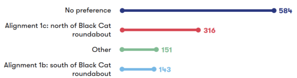
Figure 8-1: Numerical breakdown of responses to question 14a
A total of 1,194 respondents responded to this question. 26% of respondents expressed a preference for Alignment 1c, north of the Black Cat roundabout, which was more than twice as many as those who supported Alignment 1b, south of the black cat roundabout (12%). The largest proportion of respondents to this question (49%) selected ‘No preference’ whilst 13% of respondents indicated ‘Other’.
We also provided respondents with the opportunity to provide comments about this proposal; these are summarised in the table below.
|
Sub-theme |
Feedback summary |
|
Station justification |
While several respondents acknowledged and supported that Tempsford station could reduce traffic in St Neots and provide connectivity, a few respondents asked for more information about the intended users of the station. Respondents also urged us to consider the overall impacts of the station on local infrastructure and to ensure that the project aligns with planned growth in the area such as the design of the A421 and A428. There were some questions from several respondents about the financial implications of building a new station at Tempsford. Others were concerned that a new station could make the area attractive to housing developers, which they felt could disrupt local character. |
|
Station location |
Several respondents discussed the potential benefits of a new interchange station south of the A421 for strategic rail connectivity and alleviating capacity pressures on the A1 corridor. A few respondents suggested that there were no safe footpaths or cycle routes for local villages east of the A1 to access the station and requested new active travel opportunities, while maintaining existing footpaths and bridleways. A small number of respondents felt that the new station would be less accessible for St Neots residents compared to the existing East Coast Main Line station. A few respondents also felt that local community benefits would be limited due to size of the nearby community and access challenges for some local villages such as Elsworth. Many respondents suggested that the station should instead serve St Neots, the largest town in Cambridgeshire, to better meet the needs of the local population. Some respondents called for the new proposed station to be located even further north than proposed with the existing St Neots station moved south to be adjacent to create a proper interchange. There were requests to conduct a full flood assessment with several respondents noting the environmental risks of building on flood-prone areas and greenfield sites. |
|
Station design and facilities |
Respondents emphasised the importance of adequate facilities in and around the station, including active travel provision, public transport links, and accessible parking. Respondents requested more consideration should be given to emergency service access and local infrastructure, such as the A421, in planning. Some respondents commented on the elevation and the proposed two-level design of the station in both alignments and suggested a bespoke design that integrated the structure into the local landscape. They also suggested sustainable design features like green roofs and renewable energy generation. Many respondents also emphasised the importance of connectivity to the East Coast Main Line to maximise the benefits of the new station. A small number asked if the station would allow passengers to easily transfer between EWR and East Coast Main Line services, and if the track layout would support trains moving between the two lines. |
|
Alignment 1b – General feedback |
A small number of respondents supported Alignment 1b for its potential to accommodate future demand in Tempsford. They also anticipated several benefits of a new station south of the A421, including sustainable growth and economic opportunities, improved connectivity, faster line speed, greater cost effectiveness and alignment with strategic development goals. Several respondents felt that Alignment 1c had more economic benefits compared to Alignment 1b, expressing concerns about the cost, complexity, and potential delays associated with constructing Alignment 1b. There was concern from one respondent that Alignment 1b, in combination with the new road development at the Black Cat roundabout, would isolate the village of Roxton. Several respondents noted that Alignment 1b could interfere with potential developments in the area, such as a proposed business park and housing projects. There were comments from several respondents about the impact of Alignment 1b on areas such as Poets Corner, Roxton, and properties near the Black Cat roundabout, including the isolation of Rectory Farm and the demolition of residential properties. One respondent noted that Alignment 1b could affect up to 100 homes, including listed buildings, compared to fewer properties impacted by Alignment 1c. |
|
Alignment 1b – Traffic and connectivity |
Respondents who supported Alignment 1b felt that it could reduce car dependency if appropriate consideration is given to provision for active travel in the planning of Tempsford, and if existing cycle routes are utilised. There were some comments about the traffic impacts of Alignment 1b, with a few respondents raising concerns about multiple crossings of the Strategic Road Network, including the A421, Bedford Road, and the A1 Great North, which they felt added to the long-term maintenance liabilities of the scheme. If EWR Co were to proceed with Alignment 1b, respondents urged for sufficient accessibility provisions to address concerns including the height of the station, its distance from St Neots and the need to cross the heavily congested Black Cat junction. |
|
Alignment 1b – Environmental impacts |
A few respondents felt that Alignment 1b could deliver more environmental benefits than Alignment 1c. One respondent suggested that Alignment 1b could benefit wildlife if the bridges and viaducts in this area are built with bats in mind, for example. However, several respondents expressed concerns about the noise and visual impacts of Alignment 1b on nearby communities in Tempsford and Roxton, particularly due to the height of the station, tracks, and embankments. They felt that this could lead to increased shadowing, dust, debris and littering. There were a few concerns about the landscape and heritage impacts on areas such as Roxton Conservation Area and nearby listed buildings. Some expressed concern about the agricultural and landscape value of the land which Alignment 1b would be built on, which they felt should be preserved for economic and environmental reasons. There was a mixture of views regarding the impact of Alignment 1b on flooding. A few respondents suggested Alignment 1b would be less liable to flooding and higher off the ground reducing the risk further. However, several others noted that Alignment 1b would be built on significant flood plains, and that the area has experienced frequent high floods in recent years. They highlighted that any development could exacerbate flooding risks, particularly affecting St Neots and Roxton. |
|
Alignment 1c – General feedback |
Several respondents felt that Alignment 1c could be simpler, more direct and less costly than Alignment 1b due to reduced material requirements and fewer road crossings. Additionally, many respondents felt that it would have lower visual and noise impacts due to lower viaduct and embankment heights. It was highlighted by several respondents that Alignment 1c would have fewer impacts on residential properties and major arterial roads particularly in the vicinity of Roxton. A few respondents noted that it would also avoid disrupting the Roxton Garden Centre and several commented that Alignment 1c would, overall, provide better infrastructure connectivity. Several respondents referred to Alignment 1c as being more socially and economically beneficial. A few respondents expressed concerns about the station's location being further from Tempsford's proposed new town development and its potential to feel disconnected due to its proximity to the dual carriageway. A small number of respondents also raised concerns about Alignment 1c running through flood zones and one respondent commented on its potential for landlocking properties. Some respondents suggested the curve on Alignment 1c also appeared to look very tight from consultation materials compared to Alignment 1b. |
|
Alignment 1c – Traffic and connectivity |
A few respondents who supported Alignment 1c felt that it could provide better connections for commuters with the existing transport corridor. Several respondents supported Alignment 1c for its proximity to St Neots and better road access, combined with the potential to serve Tempsford and Little Barford. Several respondents highlighted Alignment 1c as being both the safer and easier passenger option. A few also noted that the reduced number of major road crossings and lower embankment height could minimise congestion at the Black Cat roundabout. They also felt it could cause less disruption during construction and operation than Alignment 1b as it would provide the best separation between the village of Tempsford and the station, reducing overall noise and disruption. Alignment 1c was noted by a small number of respondents to have fewer utility diversions and it was also noted by a few respondents to have less impact on farming operations compared to Alignment 1b. Some respondents suggested that the station presented in Alignment 1c should be central to the development in Tempsford. A small number of respondents were particularly concerned about the station being served by a minor road far from St Neots which could restrict connectivity to Tempsford and settlements along the A1 corridor. A few respondents also felt that Alignment 1c could deter residents of St Neots and new developments to the south and as they may need to walk under the A421 dual carriageway to access the station. Respondents were concerned that these factors could undermine economic growth and housing delivery. |
|
Alignment 1c – Environmental impacts |
Several respondents noted that Alignment 1c had a few environmental advantages compared to Alignment 1b as it requires fewer viaducts and crossings to major roads and is less intrusive within the countryside. They felt this could deliver reduced visual impacts. They also felt this alignment could have fewer negative impacts on Roxton and a smaller environmental footprint due to its location north of the village. One respondent supported Alignment 1c on the basis that it keeps the route further away from the Sandy Heath area and the bird sanctuary at the RSPB Lodge Nature Reserve. However, another respondent felt it raised risks associated with Alignment 1c on heritage assets, such as the deserted medieval village at Little Barford and cropmarks north-west of Black Cat roundabout which might be associated with a Roman road and associated settlement. Some respondents felt that further consideration was needed for climate change impacts, flood compensation areas, congestion impacts, and drainage modelling for Alignment 1c. Respondents also requested that EWR Co carefully plan around interactions with floodplains, the water recycling centre and nature conservation areas near the Alignment 1c. |
8.3 East Coast Main Line rail logistics hub
|
Sub-theme |
Feedback summary |
|
General feedback |
Several respondents supported a rail logistics hub for its potential to reduce lorry traffic, lower emissions, and facilitate the transport of construction materials by rail. There were suggestions to retain the logistics hub as a permanent intermodal freight hub or road-rail interchange after construction for long term environmental and economic advantages. This included suggestions to explore the potential for permanent connections between the East Coast Main Line and EWR for freight and maintenance services. A few respondents were concerned that the construction, operation, and restoration of a logistics hub could increase flood risks and impact local watercourses. They also felt that the construction of a hub could be avoided with more planning. Suggestions were made to minimise disturbance to the countryside and biodiversity, with calls for strategic placement and alternative locations to avoid such damage. Further suggestions included relocating the logistics hub to Little Barford due to better road access and suitability of the land. |
|
Option B |
A few respondents recognised Option B’s potential to reduce construction-related road traffic, and its ability to facilitate track laying eastwards ahead of the completion of the Tempsford viaduct structures. One respondent noted Option B’s compatibility with both Alignments 1b and 1c, and suggested greater use of the hub earlier in the construction programme. A few respondents supported Option B’s compatibility with the Bedford Borough Council Local Plan 2040, which allocates land at Little Barford for 4,000 dwellings, and its reduced impact on housing delivery and landscape. However, a few concerns were raised about the impact of Option B on high-grade agricultural land, local wildlife, and residential areas, including noise, traffic, and visual amenity. Respondents also emphasised the need for clear restoration plans and mitigation measures to address temporary and permanent impacts for this option. Some comments suggested that other infrastructure projects had already impacted nearby land which could be worsened as Option B would impact farm buildings, farmed land, and potentially sterilise developable land for housing projects. |
|
Option F |
A few respondents supported the proximity of Option F to existing infrastructure, which could reduce traffic impacts, particularly in Eynesbury, and require less mitigation measures. One respondent noted that Option F would be further from residential areas which could result in less noise and air quality impacts, especially in Huntingdonshire. A few respondents also preferred Option F as they felt that it would primarily impact agricultural land and allow phased development of larger sites like the Little Barford New Settlement. There was also support for this option as respondents felt it could better serve both the East Coast Main Line and EWR routes. One respondent commented on the land take required for Option F, with concerns about its impact on development schemes, heritage assets and that the hub would be too close to the station itself in this option. |
8.4 Environment and sustainability
|
Sub-theme |
Feedback summary |
|
Air quality and emissions |
While several respondents supported the project for its potential to reduce car dependency and promote sustainable transport, they emphasised the need to prioritise environmental sustainability and minimise ecological harm. A few respondents felt that the proposed Tempsford station could increase car usage, requiring a large car park and contributing to CO₂ emissions. Existing air quality issues from road traffic were also noted by a few respondents, with calls for the Environmental Impact Assessment to address potential air impacts from changes in road access to the station. One respondent was concerned about possible asbestos contamination from demolitions and the use of diesel traction for freight trains, due to the lack of continuous electrification. |
|
Operational noise and vibrations |
Several respondents expressed a preference for Tempsford Alignment 1c compared to Alignment 1b due to its potential to reduce operational noise and vibration. It was noted by several respondents that the cutting design of Alignment 1c could achieve noise reduction benefits due to the lower track elevation, which would minimise noise propagation through ground absorption. Several respondents highlighted that Alignment 1c would result in less noise for residents in areas such as Tempsford, Roxton, Wyboston, and Chawston, and a few commented that Alignment 1c would provide better separation between the village of Tempsford and the station. It was also mentioned that Alignment 1c would have fewer noise impacts on the Roxton Garden Centre and the residents of St Neots due to the lower track elevation. However, respondents acknowledged that detailed sound propagation modelling would be required to confirm these benefits. |
|
Water resources and flood risk |
Several respondents raised concerns about the potential impact of the proposed rail development on water resources and flood risk, particularly in flood-prone areas such as Tempsford, Roxton, and surrounding floodplains. A few respondents noted that this region already experiences frequent and severe flooding, worsened by previous developments like the A421 and the effects of climate change. A small number of comments were made about the increased use of concrete, which could reduce natural water absorption and exacerbate flooding. Respondents questioned whether climate change and the cumulative effects of impermeable surfaces from nearby developments had been fully considered. One respondent was concerned about building a new Tempsford station in conjunction with a ‘new town’ in a low-lying area, which could increase the risk of flooding. One respondent also noted that constructing viaducts and other infrastructure on saturated ground could further aggravate flood conditions. The risk of potential changes to floodplain dynamics was noted by a few respondents, including impacts on local watercourses such as Dean Ditch and the River Great Ouse. To address these risks, they called for more detailed flood risk assessments and mitigation plans, including the design and placement of attenuation ponds. Respondents also recommended exploring catchment management schemes to support flood attenuation and improve local bodies of water. |
|
Biodiversity and nature conservation |
While there was some support for planting trees and vegetation, respondents emphasised the need to maintain safe distances from cuttings and embankments. A few respondents raised concerns about the proposed creation of new hedgerows, noting that in some locations these appeared unnecessary, disconnected from the wider project, and could affect access to retained land and the new garden centre. Further information was requested by one respondent for the scale and management of environmental areas, particularly where high-quality grassland with historical value could be lost, potentially causing financial hardship for dependent businesses and altering the rural character of the area. A few respondents noted risks to diverse wildlife, including deer, badgers, foxes, birds, brown hares, red kites, siskins, reed buntings, and protected species like great-crested newts. A few concerns were also raised about the spread of invasive species and ecological disruption near sensitive areas such as The Gorse and the lakes near Roxton Lock. Evidence of increased biodiversity on local farms, supported by RSPB and Defra surveys, was shared by respondents. This highlighted the need to protect and expand woodland habitats and prevent flooding impacts on foraging areas for species like Barbastelle bats. While the provision of Ecological Compensation Sites along this section of the route was welcomed, including ponds, badger setts, bat boxes, and planting, respondents also suggested combining balancing ponds with former pits to enhance biodiversity. Respondents also recommended relocating restorative works to less productive land or land further to the south. |
|
Landscape and heritage |
Several respondents raised concerns about the potential impact of the rail proposal on local historical and archaeological heritage. Specific concerns raised by some respondents included possible damage to the Roman road beneath the Greensand Ridge, disruption to the former RAF Tempsford site and its associated WWII museum, and harm to the historic village of Tempsford, including its airfield and barn. The presence of significant archaeological sites was flagged by a few, including Iron Age, Roman, and Late Bronze Age remains, as well as paleoenvironmental sequences, some of which were preserved during the A428 improvement works. Further concerns raised by a few respondents focused on designated heritage assets, including the Grade II St Mary Magdalene Church, the scheduled Tempsford Bridge, and listed buildings in Roxton and Little Barford. There were also concerns about non-designated assets, such as prehistoric and Roman cropmark settlements. Respondents called for further archaeological evaluation and mitigation, and suggested using a cutting to reduce visual impact. They also requested appropriate screening to protect heritage features. |
8.5 Traffic and transport
|
Sub-theme |
Feedback summary |
|
Connectivity |
Several respondents supported the potential benefits of improved connectivity through a new interchange station at Tempsford. This included the benefits of linking north-south and east-west services, alleviating capacity pressures on the A1 corridor, and providing strategic connections to employment. They also noted the potential for better connections to the East Coast Main Line with a Tempsford station, enabling faster journeys to destinations like Cambridge, Milton Keynes, and beyond. There were some concerns that the proposed Tempsford station would not provide door-to-door connectivity and would increase car dependency. One respondent felt that the project could reduce the demand for bus services, including the X5 and 905, and noted the need for replacement links to maintain connectivity. There was also disappointment expressed by some respondents that the proposal does not include a direct connection with the East Coast Main Line or provide direct services from Bedford to St Neots. They argued that the proposal fails to meet the connectivity aims of the Project and would not alleviate traffic on major roads. |
|
Active travel and public rights of way |
Some respondents felt that the project doesn’t have sufficient active travel provisions. Particular concerns were expressed about the removal of existing public rights of way around Roxton and other villages. It was suggested that public rights of way, including those that will be built around the Black Cat Roundabout as part of the A428 improvement works, should remain open and unobstructed during construction and operation. A few respondents emphasised the need for plans to align with government policies and national standards such as LTN 1/20. There were also suggestions to create safe cycle routes to stations, and include bike racks in station designs. Respondents also suggested that there were missed opportunities to integrate active travel elements, such as permissive cycling and walking routes on major structures like bridges over the River Great Ouse and the A1. Respondents recommended exploring park-and-ride opportunities and ensuring that the project supports sustainable travel options to avoid fostering car dependency. One respondent highlighted issues such as existing flooding problems at Hen Brook underpass, and the need to minimise height differences between bridges to ensure accessibility for users of public rights of way. Respondents also called for the project to incorporate a parallel east-west active travel corridor along its entire length and to consider additional features such as hitching rails and stabling for equestrian access. |
|
Road journeys |
A few respondents supported the use of rail for transporting construction materials to reduce road congestion and carbon footprint. There were also suggestions that the new Tempsford station would alleviate traffic from congested roads in St Neots. However, some respondents felt that the proposals could worsen existing traffic issues. They noted that the proposed Tempsford station could worsen delays on roads that are already prone to congestion such as the A1, A421, and roads around St Neots, Sandy, and Cambridge. They also raised that the location of the station may be easiest to access by car, which could result in more traffic, contradicting the objective of reducing road journeys. There were also a few comments that improved road infrastructure, such as upgrades to the Black Cat and Caxton Gibbet roundabouts, might make car travel more appealing than rail. Respondents suggested a more integrated transport strategy that addresses traffic impacts on major roads, and aligns rail infrastructure improvements with road upgrades. |
|
Rail journeys |
A few respondents felt that an interchange at Tempsford would increase journey times to London and St Neots due to added stops. It was noted that accessing Tempsford station would require a car or rail journey south, with eastbound passengers needing to double back to St Neots where service frequency is limited by infrastructure. Respondents called for timetable coordination between EWR and the East Coast Main Line services. A few respondents supported a joint station and suggested at least half-hourly services at Tempsford. They also called for integration with local bus services, such as the Cambourne to Cambridge guided busway. Others recommended building the route to high-speed standards with robust connectivity plans in case of service disruption to encourage drivers to switch to rail, and emphasised the need for strong links to Peterborough and Stevenage. |
|
Freight |
Support was expressed by a few respondents for transporting construction materials by rail. Some respondents asked EWR Co to consider future-proofed freight facilities that support economic growth without increasing road congestion. There were questions about the case for passenger demand given the expected rise in freight traffic, with calls for the project to prioritise passenger services over freight. Some respondents highlighted the need for a direct connection to the East Coast Main Line for both passenger and freight services to enhance capacity and flexibility and suggested enabling East Coast Main Line electric services to divert onto the EWR line. Concerns were raised by one respondent about overnight freight operations and another respondent referenced increased local traffic from last-mile logistics. They suggested coordination with Huntingdonshire District Council to address last-mile needs, particularly in relation to St Neots. |
|
Train services |
Several respondents raised questions about the economic implications of EWR. This included suggestions by a few that driving might become faster and cheaper than taking the train for certain journeys, due to the price of train travel and parking. Respondents proposed that the route could be maintained as a tram-train system running at much slower speeds allowing both rail lines and tram lines, with street running, and functioning as a low-cost feeder line. One respondent suggested that careful consideration is needed to ensure the railway in this section is attractive to use for both EWR and East Coast Main Line users, whilst maintaining maximum capacity for highspeed non-stopping trains. Others asked that trains have adequate and accessible bike storage, with options that don’t require advanced booking. One respondent suggested the EWR train designs should take inspiration from the cycle storage on the newly reinstalled Marston Vale line, which were described as fit for purpose and well-used. They also asked for trains to consider space for passengers with small children and unfolded buggies. |
8.6 Construction and logistics
|
Sub-theme |
Feedback summary |
|
Construction timeline and cost |
There was support by a few respondents for a swift construction period. Many respondents encouraged EWR Co to explore ways to accelerate both the construction and opening of the line. Many respondents were in favour of options offering the best cost-benefit ratio, with some emphasising that cost should determine the route, particularly for the Tempsford alignment. They asked EWR Co to identify opportunities to reduce construction costs without compromising the scope of the project. |
|
Environmental impacts of construction |
The ongoing reconstruction of the Black Cat roundabout was noted by many respondents as a source of existing disruption, with fears that EWR construction could extend this for another decade, further affecting local quality of life. Respondents called for detailed mitigation plans addressing noise, visual impacts, and litter management to better understand the long-term environmental consequences. Several suggestions were made to reduce environmental harm, including using rail or water transport during construction to cut emissions and installing barriers or bunds to reduce sound pollution. Other proposals included lowering embankments to pass under existing roads, and installing stock-proof fencing to protect farmland and maintain boundaries throughout and after construction. One respondent was concerned about the construction compound near the A1 viaduct, arguing that it would be too close to the village of Roxton. |
|
Traffic and diversions |
While several respondents supported the use of a logistics hub to centralise construction activities, they noted that it would not eliminate all traffic impacts. Several respondents felt that diversions and closures would result in congestion and heavy construction traffic on unsuitable local roads. One respondent raised a particular concern about the routes around the upgraded Black Cat junction, including the road through Roxton and the existing A428 to the south of St Neots. Respondents also noted the need for careful consideration of access roads, particularly around the London North Eastern Railway line and B1040, to accommodate both heavy goods vehicles and agricultural machinery safely. They also urged for traffic measures to be coordinated with the A428 Black Cat to Caxton Gibbet improvement scheme. The overall disruption caused by the project during construction was flagged as concerning by some, with some respondents urging for a less disruptive approach. Respondents asked for access to farms to be maintained throughout construction, with short, well-advertised closures and alternative access routes for utility diversions. There were also suggestions to consider separate accesses for farms and properties to maintain safety and security. |
|
Construction safety |
Respondents emphasised the importance of the health and safety of construction workers and the public. They noted several risks to be considered including heavy goods vehicles on narrow streets and construction traffic parking on main roads. They also noted the safety risks associated with hours of work and the proximity of homes to working areas.
|
8.7 Community benefits and impacts
|
Sub-theme |
Feedback summary |
|
Access to jobs, education and healthcare |
A few respondents recognised the potential benefits of the project, such as better access to jobs, education, and healthcare, particularly for young people and working-age residents in St Neots. They felt that the project could enhance commuting efficiency, reduce road traffic, and support economic growth. Some respondents felt that current proposals could make commuting to Cambridge, Bedford, or Milton Keynes difficult for residents. Several commented on the potential negative impacts on local employment, particularly for the Roxton Garden Centre, which is a key walkable employment site for Roxton residents. A few respondents noted the importance of ensuring that changes do not disrupt public health or healthcare delivery, including emergency response times, during construction or operation. They also asked that the temporary freight hub does not lead to a reliance on low-wage employment opportunities. |
|
Local economy |
A few respondents welcomed the potential for improved economic outcomes through enhanced connectivity to growth areas like St Neots and Huntingdonshire. They noted potential benefits including increased footfall, support for town centre retail, inward investment, and growth in visitors. Alignment 1c was seen as less disruptive with a lower impact on employment and local businesses, preserving the Roxton Garden Centre and its associated jobs. Alignment 1b was seen to have negative impacts on the local economy as it uses land allocated for employment use in the Bedford Draft Local Plan. One respondent felt that a new station at Tempsford could divert footfall and business away from St Neots and reduce use of the X5 bus service. Concerns were also raised about the impact of construction on local businesses, such as road closures, rerouting, and increased heavy goods vehicle traffic, with suggestions for a support fund to help those most affected. Respondents highlighted the need to consider the economic opportunities and connectivity from Tempsford to St Neots and Huntingdon, including Alconbury Weald, and requested further discussions on strategic growth scenarios. They also emphasised the need for EWR Co. to work closely with local authorities to plan for legacy connectivity and future-proof the eastern route. |
|
Local communities |
While some respondents welcomed the potential for improved connectivity and economic development, they stressed the importance of careful planning to reduce negative effects and ensure benefits for local residents. Additionally, a few respondents supported preserving valued local assets, such as the Roxton Garden Centre, which serves as a community hub. Other respondents felt the rail line would fail to deliver meaningful benefits to local communities, including St Neots and surrounding villages. One respondent raised specific concerns that the rail line could act as a physical barrier around towns like St Neots, limiting future growth and weakening transport and communication links. Issues such as noise pollution, visual disruption, and increased pressure on local infrastructure, including healthcare and housing, were also anticipated. |
|
Safety and wellbeing |
Respondents raised safety concerns for pedestrians and cyclists accessing the station. They noted that Alignment 1b would require pedestrians to cross a dangerous roundabout. They also highlighted the lack of safe walking or cycling routes from villages west of the A1 to either proposed Tempsford station site. Additional concerns were raised about the health and safety risks associated with Alignment 1b. Respondents requested that all future communications include contact numbers for support services. It was also emphasised that any changes should not negatively affect public health or healthcare services, including ambulance response times, during either construction or operation. Concerns were expressed about the broader impact on quality of life, including potential effects on mental health. |
|
Impact on equality and protected characteristics |
Some respondents highlighted potential benefits, such as better access to hospitals for disabled people and improved educational opportunities for young people. However, they also raised concerns about how accessible the railway would be, noting that current designs may pose challenges for disabled and older passengers. Specific issues included the height of bike hooks and the ease of changing trains at the proposed Tempsford station. Respondents stressed the importance of safe and well-designed pedestrian and cycle routes, especially between Roxton and the Tempsford 1c station, to ensure children can travel safely. Additionally, respondents urged planners to consider connectivity to rapidly growing areas like the eastern side of St Neots. Many suggested that the northern route of Alignment 1c would be more suitable, as it is located farther from a nearby school. |
8.8 Land and property
|
Sub-theme |
Feedback summary |
|
Residential land and properties |
Several respondents commented about the impact of the proposed rail alignment on residential properties, with concerns about the disruption to quality of life. Many respondents noted that properties close to the proposed rail alignment may experience significant noise disruption, reduction of natural light in homes from viaducts, and structural damage. One respondent felt that a high level of Huntingdonshire’s housing stock could be lost due to the current alignment of the project, which would exacerbate the housing need in the area further. They also suggested reconsidering the extent of environmental areas and planning access arrangements to lessen the impact on properties. |
|
Property values |
Many respondents expressed concerns that the construction and operation of the rail line would lead to a reduction in property values and make it more difficult to sell properties, particularly for those living in scenic rural areas. A few respondents noted the surrounding rail line and new roads could cause noise and air quality disruption, making nearby properties less desirable. With concerns that the impact on property values and sales could continue until works are completed, respondents asked EWR Co to engage in early discussions with landowners to address these concerns. |
|
Business land and properties |
Many respondents raised the risk of substantial land loss, including areas of high-grade agricultural land under both Alignment 1b and 1c, and the logistics hub Option F. One respondent was concerned that some farms could lose up to 45% of their area and farm buildings. A few respondents raised worries about losses of income, increased costs, and potential interruption of operations, with some suggestions for alternative alignments or locations for design features to minimise the impacts of land take. A few respondents questioned how viable land that was temporarily acquired would be after use by EWR. One respondent expressed opposition to tree planting to retain as much land for agricultural purposes as possible. There were also calls to review access arrangements and biosecurity measures for nearby farms. The need to minimise impacts on agricultural businesses and ensure timely replacement of affected buildings was raised. One respondent suggested that EWR Co should notify local authorities about potential planning applications for replacement buildings as soon as they submit their development consent application for the project. Suggestions to reduce the impact of farmland included reconsidering land take required for environmental mitigation areas and using less intensively farmed land for temporary storage or construction. Respondents also recommended Alignment 1c to reduce farmland loss, and to follow existing travel corridors. |
|
Planned and future developments |
It was noted by several respondents that the project aligns with Huntingdonshire District Council’s Local Plan to 2036 which includes strategic transport links and developments, such as the Strategic Expansion Area at St Neots East, providing 3,820 homes and employment space. While respondents acknowledged that a proposed station at Tempsford could provide a vital rail link to Cambridge and reduce in car travel, they suggested that these benefits would be substantial only if major housing and employment developments are permitted in the area. Respondents also recognised the potential of the green village at the former Tempsford airfield to accommodate new housing and station users and noted the government support the site for a large settlement. Some suggested revising the proposals to lessen disruption to future property developments. Some respondents further suggested that a Tempsford North station may offer better integration with the proposed new settlement at Little Barford. Respondents highlighted several areas of land in Roxton and St Neots that could be used for residential or educational developments. They asked EWR Co to reconsider proposals that impact areas of development opportunity to avoid disruption. |
|
Utilities |
ne respondent commented about the impact of utility diversions and crossings, and expressed concern that utility providers may not be interested in supporting the project. Respondents requested clear information and early engagement about the extent of proposed utility diversions and alternative access routes during road closures. They also stressed the importance of maintaining utility connections and buffer zones throughout the construction and ensuring practical agreements for future maintenance and repairs. Respondents reiterated the importance of ensuring works related to utilities are resilient to flooding and climate change impacts. It was also requested by one respondent that a potential new substation in the area should be located away from the national gas pipeline. Additionally, one respondent queried how the existing water infrastructure, which they felt lacks clean water facilities for existing houses in Cambridgeshire, would be able to support new planned properties in Tempsford. A few respondents also highlighted the potential adverse impact of high-voltage cable installations on property operations and development, suggesting alternative routes to minimise disruption. |
9. Croxton to Toft
This chapter presents feedback received on proposals for the Croxton to Toft section of the EWR route. This route section is approximately 19 kilometres (12 miles) long. It begins at the roundabout to the east of St Neots, running north of Cambourne and the new dual carriageway, which will be known as the A428, before crossing under the A428 and ending at the B1046 between Toft and Comberton. This section includes the construction of a station north of Cambourne and a tunnel beneath the A428 and Bourn Airfield.
A total of 895 responses were received about this route section.
Some responses in this section reflect views or interpretations that may not accurately reflect the proposals set out in the consultation. To understand the context behind the feedback presented, it may be useful to refer to Chapter 14 of the 2024 Consultation Document. The consultation document and other consultation materials are available on our website: eastwestrail.co.uk/consultation2024
9.1 General route section
|
Sub-theme |
Feedback summary |
|
Route alignment |
Respondents expressed a range of views on the proposed route alignment for the project. Several respondents were supportive of the southern approach to Cambridge, including the decision to route the track via Tempsford and to connect Cambourne to the railway. However, many respondents believed that a northern approach would deliver better connections for new developments and growing northern settlements such as Northstowe, Waterbeach and Stansted Airport, while impacting fewer villages than the proposed route alignment. Several respondents also suggested that the route should follow the existing travel corridor and avoid altering the rural landscape. |
9.2 Cambourne station
|
Sub-theme |
Feedback summary |
|
Connectivity |
Several respondents expressed support for a new station at Cambourne, highlighting its potential to serve as a key travel hub and providing improved connectivity to destinations including Cambridge and St Neots. A few respondents believed that the station was essential for supporting the local economy and providing a sustainable transport option for residents and surrounding communities. While it was noted that the station could reduce road congestion, respondents emphasised the importance of integration with bus services and active travel routes alongside appropriate facilities to improve connections to and from surrounding areas. Several felt that locating the new station on the north of the A428 could result in poor connections to Cambourne, particularly Lower Cambourne and West Cambourne. They proposed locating the station closer to the A428 junction or south of the A428 for better access. It was also noted by some respondents that the station's distance from the town centre and housing developments could increase car dependency, contributing to traffic congestion and discouraging walking and cycling to the station. Further concerns were raised by several respondents about the station’s impact on local roads, residents and nearby villages. Several respondents felt the current plans focused too heavily on enabling housing development, without delivering enough transport benefits for local communities. The lack of stations between Cambourne and Cambridge South was seen as a missed opportunity to improve connectivity for nearby villages. Some also questioned the need for the station given existing bus services and the proposed Cambourne to Cambridge busway, which they felt might offer more practical and accessible option for commuting to Cambridge. Overall, respondents encouraged improved door-to-door connectivity. They suggested collaborating with local authorities on integrating EWR with both existing and planned transport networks to support those without access to a car, including older people and students. Further comments recommended creating a travel hub that links with the Scotland Farm hub and the proposed busway. |
|
Station access and facilities |
Respondents felt that the northeastern location of the station could be difficult for cyclists to access as they may have to cross a busy dual carriageway. They proposed locating the station to a more central or northern location to provide better active travel access, including moving the station closer to the existing entrance to Cambourne. Several respondents encouraged facilities for cyclists to further encourage active travel. Suggestions included secure cycle storage around the station and on trains, and facilities for e-scooters. There was also emphasis on the need to design safe, well-lit, and paved active travel routes. Suggested features included a bridge from Upper Cambourne to the station, cycleways across fields from surrounding villages, and dedicated pedestrian and cycle paths across the A428. There was emphasis on the need to ensure that the station meets a wide range of community needs. This included recommendations for accessible facilities such as lifts and ramps in the station and footbridges with ramps and stations to allow easy movement for wheelchairs and bikes. ‘Changing Places’ toilets were also requested. Other suggestions included frequent, reliable bus services, tramways, along with measures such as automated shuttles to improve station access and connections with other public transport. Respondents raised the need for sufficient, secure, and affordable parking, including requests for electric vehicle charging points. A multi-storey car park was also proposed to prevent overflow parking in residential areas. Additional suggestions for the design of the station included creating a civic square that incorporates architectural designs and sustainable features like solar panels. |
9.3 A428 Bourn Airfield crossing
|
Sub-theme |
Feedback summary |
|
Cost |
Several respondents were concerned about the cost of the proposed cut and cover tunnel that passes beneath the A428, the Bourn Airfield development site, and Highfields Road. Specific concerns were raised about revisiting planning stages and other potential delays that could increase the overall cost of the project. Some respondents supported a cut and cover tunnel as a less costly approach. However, many respondents felt that the selection of the cut and cover tunnel method prioritises cost savings over the well-being of affected communities, especially those in Highfields Caldecote. Some respondents suggested that a mined or bored tunnel, though more expensive, would be a better long-term solution with less disruption to the environment, local businesses, residents, and existing infrastructure. Further comments called for cost analysis that considered the full social and economic cost of the tunnel, including its long-term benefits and opportunity costs. Respondents raised several proposals to potentially reduce costs including constructing a bridge instead of a temporary bypass on the A428. They also suggested the consideration of alternative construction methods like jacked box or box slide options. Further comments recommended ensuring passive provision for future electrification and using trenches or road-over-rail crossings to minimise land use and long term-costs. Respondents encouraged incorporating sustainability into the construction of the project and suggested approaches including using recyclable materials like steel and using machinery repurposed from other projects, like HS2. |
|
Traffic and diversions |
Several respondents raised concerns that construction of the proposed tunnel could disrupt utilities and block the main access routes to Highfields Caldecote, such as Highfields Road and St. Neots Road, for extended periods. They noted closing key roads could isolate the community, affect access to the BP garage shop and disrupt public transport services such as the proposed Cambourne to Cambridge busway and the Citi 4 bus stop. To reduce disruptions, respondents requested suitable diversions between Caldecote and Cambourne during road closures. Some suggested that a mined tunnel, rather than a cut and cover approach, could mitigate some of these potential impacts by reducing the need for extensive road diversions and closures while maintaining access to key routes and services. Several respondents also noted that both the temporary and permanent diversion routes could increase walking distances, which would particularly disadvantage older people and disabled people. Further concerns were raised by several respondents, noting that the proposed diversions could disrupt school and work commutes and access to local amenities. Respondents urged that active travel be fully considered in the Bourn Airfield tunnel plans. Suggestions included adding landscaped walking paths or parks over tunnel sections, as well as a dedicated footway and cycleway along the tunnel route to improve connectivity. They also recommended constructing a road and cycle path through Bourn Airfield to Cambourne to increase connectivity. There were also concerns that steep gradients could result in more pollution from diesel trains, while others urged for a tunnel that would support gentle gradients to accommodate freight operations. |
9.4 Environment and sustainability
|
Sub-theme |
Feedback summary |
|
Air quality and emissions |
Many respondents were concerned about the potential volumes of air pollution, particularly due to increased emissions from cars on temporary and permanent roads. Additionally, the use of diesel freight trains was seen by several respondents as outdated and in misalignment with net-zero goals. Respondents proposed electrifying freight trains instead to reduce emissions. They also felt that the elevation of the route west of Caldecote could increase emissions, with suggestions to reduce elevation to lower emissions over the railway's lifespan. Further comments emphasised the need for the project to support reduced car dependency and improve air quality in the area. |
|
Operational noise and vibrations |
Many respondents were concerned that, when operational, EWR trains could cause significant noise and vibration, disrupting nearby residential areas, schools, and natural habitats. Respondents were particularly worried that noise from road bridges, tunnel exits and entrances, and elevated sections of the railway could be amplified over a wider area. To address these concerns, respondents recommended sinking sections of the railway into deeper cuttings with embankments to help suppress noise. Further soundproofing measures proposed by respondents included implementing barriers and planting trees, alongside moving the railway further away from residential areas and schools. |
|
Water resources and flood risk |
A small number of respondents were concerned that the project could worsen existing flooding issues and increase flooding risks if drainage designs aren’t adequate. Areas such as Bourn, Hardwick, and Elsworth, were noted by a few respondents as being particularly vulnerable to flooding due to narrow roads. It was also highlighted by a small number of respondents that construction could worsen conditions by compacting clay soil, blocking land drains and disrupting natural waterflow, particularly around local watercourses such as Bourn Brook and Callow Brook. Several respondents also noted that local water supply is already under strain and raised concerns that using existing water infrastructure to support increased demand from new housing developments linked to EWR could lead to further water supply pressures. There were also requests to ensure proper maintenance of drainage systems to ensure uninterrupted utility services. Additionally, many respondents raised concerns about the proposed cut and cover method for the Bourn Airfield tunnel, with several respondents noting that it could harm chalk aquifers, disrupt drainage systems, and increase surface water runoff. It was suggested that a mined tunnel would be a safer alternative, with less risk to watercourses and underground aquifers. There was also emphasis on the importance of early engagement on drainage plans to help manage flood risks. This included maintaining balancing ponds and water levels for local fisheries alongside ensuring protection for aquifers and chalk streams. Some comments suggested that the project should be delayed until new reservoirs are operational and there were requests for replanting strategies to mitigate droughts. |
|
Biodiversity and nature conservation |
Many respondents expressed concerns that both the construction and operation phases of the project could pose risks to wildlife, including birds, amphibians, mammals, and legally protected species. They questioned whether the proposed Biodiversity Net Gain measures were sufficient, particularly due to the potential loss of ancient trees, hedgerows, wildlife corridors, and the broader impact on local ecosystems. Respondents advocated for more robust actions to enhance biodiversity and reduce environmental harm. Suggestions included implementing targeted tree and shrub planting. They also highlighted the importance of creating and safeguarding valuable natural habitats, especially in flood-prone areas where wetland habitats could be established. There were also calls to rewild land once the project has finished using it. Many respondents raised specific concerns about the potential impact on Barbastelle bats, a legally protected species. It was noted that foraging routes and maternity roosts in Hardwick Woods and the Wimpole Special Area of Conservation could be disrupted by light pollution, noise, and ground disturbance. Respondents called for dedicated surveys to assess the project's impacts on these bats, as well as broader wildlife surveys. The effectiveness of proposed mitigation measures, such as green bridges and bat underpasses, was also questioned. Respondents cited a lack of evidence supporting their success for Barbastelle bats. To improve these measures, it was suggested that green bridges should be unlit, wide, and densely planted to support uninterrupted bat flight paths alongside the use of temporary flight paths until green bridges are fully established. It was also suggested that a mined tunnel would be a more environmentally sensitive alternative to a cut and cover tunnel by offering protection for habitats and reducing risks to bats. |
|
Landscape and heritage |
Several respondents were concerned that the project could cause damage to the historic character of the local area and emphasised the need for thorough assessments and mitigation measures to safeguard affected areas and avoid urbanisation. This included concerns about vibration from the railway causing structural damage to ancient footpaths, rights of way and listed heritage assets such as properties and barns. Concerns were also voiced by several respondents about the potential damage to farms, woodland, chalk streams, and the countryside. Respondents suggested following existing transport corridors like the A428 and A14 to minimise damage to these structures and features. Additionally, several respondents were concerned that design elements, such as high embankments and large-scale road bridges, could intrude on rural landscapes. To reduce these visual impacts, they advocated for a design that is better integrated into its surrounding environment. Suggestions included reducing the size of embankments and using pillars for support alongside screening the track with trees and vegetation. Underground electricity transmission lines were also proposed to further reduce the visual impact of the project. They also raised the visual benefits of a mined tunnel over the proposed cut and cover approach. |
9.5 Traffic and transport
|
Sub-theme |
Feedback summary |
|
Connectivity |
Several respondents felt that the proposed route had the potential to disrupt connections between villages, communities, and essential services. A northern route was proposed to deliver better connections for new developments and growing northern settlements such as Northstowe, Waterbeach and Stansted Airport, while impacting fewer villages. There were also requests to integrate the project with other transport initiatives, such as the proposed Cambourne to Cambridge busway and ensuring compliance with government active travel strategies. |
|
Active travel and public rights of way |
A few respondents felt the project prioritises access for cars, and focuses less on active travel and public transport. They argued that this does not align with sustainable transport goals. Specific concerns were raised by several respondents about road closures and diversions affecting walking, cycling, and bridleway routes, making daily journeys longer and less convenient. A small number of respondents expressed concern about Caldecote Footpath 9, which was highlighted as essential for access to services and schools. Respondents asked for suitable alternatives to be provided where routes are disrupted. Some called for a Rights of Way Improvement Plan to ensure continued access for vulnerable users where paths are affected. Respondents stressed the need to align the project with local active travel strategies and improve links to nearby villages and transport hubs. They also raised several suggestions to further accommodate active travel to and from stations. This included proposals to upgrade east-west walking and cycling routes and create direct, safe cycling links, particularly along Old North Road and between villages like Toft, Hardwick, and Cambourne. Further comments requested bridleways be maintained or replaced to enable equestrian access. |
|
Road journeys |
A large number of respondents raised concerns about the project’s potential impact on congestion and journey time in villages. Many respondents reported concerns including the risk of increased traffic congestion, rat-running and disruption due to road diversions. It was also noted by several respondents that congestion could increase if housing developments nearby add more cars to local roads. Additionally, several respondents were concerned that new EWR services could lead to existing bus services being cancelled or cut back, potentially making local journeys difficult for those without a car. They emphasised the need for comprehensive traffic modelling and mitigation plans to address these concerns and ensure minimal disruption to local communities. A small number of respondents raised concerns that the project could undermine the proposed Cambourne to Cambridge busway, which was seen as a more effective transport solution in terms of journey time, frequency, cost, and coverage by some respondents. Many called for better integration between the project and the proposed busway. |
|
Rail journeys |
Respondents felt that a local station was needed as some respondents felt that door-to-door travel times, including access to stations and onward travel, could exceed current car travel times. |
|
Freight |
Respondents commented on the broader impacts of freight within the local area. Several cited concerns about the frequency and speed of freight trains, and several also were apprehensive about the potential for night-time services to affect the quality of life for nearby residents. Some suggested that using the Ely junctions for freight could be a less disruptive alternative. |
|
Train services |
Some respondents suggested using tram-trains, lighter rail vehicles capable of running on tram tracks without requiring a tunnel. It was noted that their enhanced acceleration and braking ability could help to make the future train timetable more efficient. Respondents asked about the cost of travel on EWR between Oxford and Cambridge. Some were concerned that train fares may exceed that of bus fares, potentially limiting access to EWR for those on low incomes. It was suggested that combined tickets for EWR and bus services could make door to door journeys more affordable. Additionally, some respondents recommended exploring further opportunities for additional tracks, or reusing existing along the route to accommodate expected increases in demand. |
9.6 Construction and logistics
|
Sub-theme |
Feedback summary |
|
Construction timeline and cost |
Some respondents urged the project to be progressed and completed swiftly, with some expressing dissatisfaction with the proposed length of the construction period. There were also some requests to compensate residents that are affected in the event of any delays that extend the length of the construction period. Some comments requested a clear construction approach that is coordinated with other local projects such as the A428 upgrades, the Bourn Airfield development site and the proposed Cambourne to Cambridge busway to reduce delays. A few respondents also raised the need to avoid plans that could interfere with the delivery of North Cambourne, which they noted would require confirmation in the Local Plan and could be constructed after the new station is built. Additionally, a small number of respondents proposed measures they believed could help reduce project costs. These included adopting the northern approach to Cambridge as a potentially cheaper alternative and trenching the railway in suitable locations. |
|
Environmental impacts of construction |
Several respondents were concerned that construction phases could bring years of disruption, including noise, air and light pollution and dust to villages such as Hardwick. There were also concerns that affect continued disruption could have long-term impacts to the local quality of life and local businesses. It was also noted that construction activities could create noise, light and ground disturbance for wildlife, particularly the legally protected Barbastelle bats and rare species of insects. Some respondents recommended that ecologically sensitive zones should be avoided to mitigate the impact of construction and protect these species. There was further emphasis on the need to maintain boundaries and that EWR Co must ensure that areas used for construction are repaired and useable after temporary use. |
|
Traffic and diversions |
Many respondents raised concerns about the impact of construction on local roads, particularly the A428, B1046, and surrounding routes where they requested that disruption is minimised and that minimum service levels are maintained. One respondent also suggested using prefabricated structures for road crossings to reduce disruption. Some respondents requested that access to areas such as Highfields Caldecote, Childerley Estate, and Frogs Hall are maintained throughout construction. Similarly, respondents asked that public rights of way remain open, with safe crossings or diversions to accommodate pedestrians and cyclists. Several comments raised that Main Street is the only southern route out of Highfields Caldecote. They noted that the street is narrow and could be unsuitable for diverted traffic or heavy vehicles. They also raised the risk of diversions on narrow roads causing potential damage to road surfaces, verges, and historic structures, as well as increased safety risks for pedestrians and cyclists. To mitigate these impacts, respondents requested clear traffic management plans alongside well-advertised road closures, and short, convenient diversions. They also requested continued access to schools, public transport, and essential services as well as unobstructed access for emergency service vehicles. |
|
Construction safety |
A few respondents commented on the safety risks of diverting a dual carriageway offline during construction. Some questioned whether all steps had been taken to reduce these risks before choosing this approach. There were calls to avoid major road diversions during works wherever possible. They also highlighted the need for safe pedestrian access to local amenities, such as the BP garage, shops, and bus stops. Additionally, there were safety concerns about the proximity of construction compounds to residential areas. This included several respondents who raised the risk of complex construction activities, and large temporary working areas causing structural damage to nearby properties. Some comments suggested moving these sites further away to reduce potential health and safety impacts on nearby communities. Further concerns were raised about heavy goods vehicle traffic travelling through residential areas, worsened by cars parked along main roads and narrow pavements that restrict road space. They also noted that icy or treacherous roads in winter could increase the risk of accidents and even cut off access to villages in the event of a collision. Some respondents were unsure of the project's ability to avoid disrupting essential services like water, gas, electricity, and sewer systems during construction. They referred to past rail infrastructure projects that had led to accidents, delays, and compensation claims due to damage to local utilities. |
|
Construction compounds |
Some respondents raised concerns about the proposed construction compound at the Bourn Airfield development site, north of Highfields Caldecote, citing unnecessary disruption and negative impacts on residents. It was suggested that an unused area within the bounds of the airfield should be used instead. They stated that this area has a pre-existing access road for offices, vehicle storage, worker rest areas, and material handling. A respondents raised that poorly planned construction compounds could pose risks to wildlife, particularly the maternity roost of Barbastelle bats at Hardwick Wood that is near proposed working areas. There were also concerns about the use of a proposed wetland nature reserve field as a compound. Respondents felt that the project should avoid using additional wetland, woodland, and grassland habitats north of the rail route. One respondent expressed concerns about the social impacts of multiple construction compounds planned around Hardwick, including prolonged exposure to portable cabins, mud, and dust. There were also questions about the future of construction compounds in Toseland and Yelling, specifically whether the land would be returned to agriculture or be developed. There were concerns about the proposed direct access from the A5 to a nearby compound, citing safety and journey reliability concerns, as well as requests for further engagement to explore alternative access options or relocation of the compound. To help alleviate disruption, respondents suggested that the local communities should inform the location of construction compounds and access routes. Additionally, some respondents suggested exploring alternative compound locations to reduce local congestion and road safety risks alongside clear signage to prevent confusion for customers of local businesses. |
9.7 Community benefits and impact
|
Sub-theme |
Feedback summary |
|
Access to jobs, education and healthcare |
Many respondents supported proposals for this route section, citing benefits such as improved connectivity for residents to reach employment centres in Cambridge and London. They also raised the benefit of improved access to educational and healthcare facilities once the railway is operational. In contrast, many respondents noted that construction and road closures could disrupt daily commutes for students, staff, and residents and suggested moving the route further west to reduce its impacts on the village and Comberton Village College. Some respondents emphasised the importance of maintaining bus services, which are considered vital for residents without cars. There were also concerns that temporary closures or diversions could lead to permanent loss of these services, isolating communities and limiting access to education, work, and other amenities. A few respondents also raised concerns about reduced access to healthcare and increased emergency services response times due to diversions and road closures. |
|
Local economy |
Some respondents were concerned that EWR could cause significant disruption to the local economy during both the construction and operation of the railway. This included specific concerns about road diversions potentially disrupting agricultural operations, local businesses, and access to essential services. Many respondents expressed concerns about the loss of farmland and associated livelihoods, including the possibility that relying on economies of scale may no longer be viable for businesses. While some respondents supported the potential for new stations to encourage investment and new developments, they emphasised the need for appropriate mitigation measures. A few felt that, given the project's estimated cost, it should deliver more tangible benefits for the local community including compensation for affected businesses. Some respondents suggested that the project should be reconsidered, or alternative transportation solutions explored to avoid harm to the region's economy. Respondents also inquired about the potential for a community fund for the project. |
|
Local communities |
Some respondents noted the potential benefits of EWR, such as reduced car traffic, shorter rail journeys, and improved quality of life. They also noted the economic and environmental advantages of connecting St Neots and Cambourne to Comberton which could support business and leisure activities. Some respondents called for stations in more villages along the route, including Highfields Caldecote. They felt that the proposals would not provide any notable benefits for villages without stations between Cambourne and Cambridge South. Respondents suggested that the proposed route could cause irreversible damage to Highfields Caldecote. They suggested that a northern route would be a better alternative, which was seen to have a higher benefit-cost ratio and affect fewer villages. To reduce the impact on local communities during construction and operation, a large number of respondents proposed avoiding routing the railways through villages and maintaining pedestrian and vehicle access to essential services like shops and bus stops. Some respondents requested compensation for residents affected by construction, including those living near construction zones. They also suggested measures including grants for local projects and buyouts for night workers impacted by noise. |
|
Safety and wellbeing |
Some respondents raised concerns about the safety of students walking or cycling to local schools. These concerns included concerns about increased traffic, unsafe pathways, and the potential for accidents involving buses and heavy goods vehicles on narrow roads around schools. A large number of respondents also raised potential safety, health and wellbeing risks due to noise and air pollution as well as the extended risk of traffic accidents over the proposed construction period. Further comments highlighted the importance of community resources and green spaces to physical health and wellbeing. Additionally, some respondents raised safety concerns about temporary road diversions, increased traffic on narrow roads, and the isolation of villages due to blocked access routes. There were also concerns that this could delay emergency services and cut off access to healthcare facilities such as Bourn doctors’ surgery. A few respondents suggested that construction traffic should avoid using residential roads to minimise risks to local communities. |
|
Impact on equality and protected characteristics |
Many respondents raised concerns about diversions that would increase walking distances to essential services which could disproportionately affect disabled people, older people and students. They particularly noted that the closure of St Neots Road and Highfields Road could isolate residents without cars and discourage active travel due to increased journey times. Concerns were also raised about the impact of construction on the learning environment at Comberton Village College, with some suggesting investment in educational facilities to reduce the disruption. Some respondents highlighted the need for safe and accessible routes for students and residents, alongside measures to mitigate noise during construction and operation. One respondent also noted that increased traffic could also limit access to a village playground. Some respondents also urged for any diversions of footpaths and roads to consider accessibility, especially in areas with high traffic levels. This included proposals for accessible infrastructure, such as paved footpaths and cycleways, to accommodate wheelchairs, pushchairs, and bicycles. One respondent called for compensation and relocation assistance for affected homeowners with disabilities or mobility challenges. Further suggestions included ensuring extra walking distances for diversions and minimised alongside engaging with schools and community groups to ensure that the project supports accessibility and connectivity for all residents. |
9.8 Land and property
|
Sub-theme |
Feedback summary |
|
Residential land and properties |
Many respondents raised concerns about the project’s impact on residential areas, particularly in the Birdlings housing estate, Highfields Caldecote, and Bourn Airfield. The proximity of the proposed route to both existing and new housing developments was seen by several respondents as likely to affect quality of life, access to services, and local infrastructure. The potential demolition of homes, farmhouses, and agricultural buildings, such as Two Pots Farm and North East Farm, was criticised by several respondents and described as upsetting, with implications for livelihoods, family businesses, and community ties. Some proposed aligning the route more closely with the A428 upgrade to reduce compulsory acquisition costs, avoid disruption, and prevent the sterilisation of productive land. There were also calls from some respondents for compensation, including a more flexible Need to Sell scheme, a blight scheme, and funding for affected communities such as Caldecote. This included compensation for noise, air, and light pollution. There were also suggestions for mitigation measures such as double glazing, screening, and sound barriers to reduce the noise impacts of construction works and train movements. |
|
Property values |
Several respondents expressed concern about the potential negative impact of the project on property values and a few highlighted Highfields Caldecote as an area that could be particularly affected. A small number of respondents anticipated devaluations due to construction noise and environmental disruption, and extended traffic impacts. Issues such as reduced housing demand, difficulty selling homes, and financial hardship for those needing to move were also mentioned by several respondents. One respondent noted that property values had already declined 20% since the project was announced, and a few respondents mentioned that that ongoing uncertainty could further discourage investment. The possibility of compulsory land acquisitions and safeguarding directions was seen by a few respondents as adding to the instability and complicating planning permissions. While one respondent believed a new station in Cambourne could boost property values there, others felt that better alternatives should be explored to avoid negative impacts elsewhere. Several respondents called for fair compensation for affected homeowners. |
|
Business land and properties |
Some respondents were concerned that the proposed route could disturb farmland, potentially making large areas unfarmable and creating landlocked parcels that could restrict access for users of modern agricultural machinery. They noted that maintaining access for large equipment, such as combine harvesters, was essential and requested unobstructed movement between land parcels without relying on public highways. Additionally, a few respondents highlighted the potential loss of access to internal farm tracks and roadways, which are important for daily operations. A small number of respondents were also worried about the rerouting of private access roads. This included requests for clarification on the use of proposed overbridges for farm access, the maintenance responsibilities of new access roads and easement rights for long-term use. They also requested that farm access should be maintained or replaced with separate, safe, and operationally viable routes, ensuring no conflict with construction land uses. One respondent suggested building secure, fully functioning replacement farmyards before existing ones are removed, with access provided from both sides of the railway without using public highways. A few respondents raised concerns about damage to drainage systems, ditches, and soil structure, which could permanently affect land fertility and productivity. Respondents asked for measures to protect and restore soil quality and drainage, and requested clear commitments to restore land post-construction. Further comments requested clarification about access arrangements and the management of land post-construction. There were also requests for the option to retain ownership and manage returned land under EWR’s guidelines. There were also suggestions including undergrounding electricity lines to reduce the impact on retained land and providing bridges with sufficient clearance for agricultural vehicles to access severed land parcels. Specific concerns were raised about the scale of land that could be lost at farms north of Highfields Caldecote potentially threatening their operations and employment. There were also concerns about land loss at Childerley Estate and Papworth Everard, with respondents questioning the necessity of the proposed land use. Adjustments to the vertical alignment near Tithe Farm were also proposed to reduce land use and infrastructure requirements. |
|
Planned and future developments |
A few respondents highlighted the need for integrated development with future housing projects,. They also noted the importance of ensuring that overbridges and access points are sufficient for potential future developments. There were also concerns from several respondents that the EWR route could drive new housing developments, particularly north of Cambourne and around the Bourn Airfield, exacerbating existing issues with water supply, drainage, and flooding. A few respondents felt that these developments are not aligned with current or emerging Local Plans and could strain infrastructure, including roads, healthcare, education, and other resources. Increased congestion was also a concern for a small number of respondents as they expect only a small proportion of new residents to use the railway. |
10. Comberton to Shelford
This chapter presents feedback received on proposals for the Comberton to Shelford section of the route which runs between Comberton and Harston, where EWR would join the Shepreth Branch Royston Line, and improve the existing railway between Harston and Addenbrooke’s Road in Cambridge. This part of the route is approximately 14.3 kilometres (8.9 miles) long and includes the construction of Bourn Brook Viaduct, Chapel Hill tunnel and Hauxton junction.
A total of 1,263 responses were received about this route section.
Some responses in this section reflect views or interpretations that may not accurately reflect the proposals set out in the consultation. To understand the context behind the feedback presented, it may be useful to refer to Chapter 15 of the 2024 Consultation Document. The consultation document and other consultation materials are available on our website: eastwestrail.co.uk/consultation2024
10.1 General route section
|
Sub-theme |
Feedback summary |
|
Route alignment |
Respondents expressed a range of views on the proposed route alignment for the project. Several respondents supported the southern approach into Cambridge. This included a small number who highlighted its potential to connect key locations such as Addenbrooke's Hospital, research centres, and the Cambridge Biomedical Campus. The benefits for communities in south Cambridge and for freight transport were also highlighted. A large number of respondents also raised concerns about the environmental impact of the proposed route, highlighting the southern approach into Cambridge as more damaging compared to a northern approach. However, a large number of respondents questioned the rationale for prioritising the southern route over a northern alternative (considered in the 2023 Route Update Announcement), which they argued would be shorter, cheaper, less disruptive, and better aligned to connect with existing and planned developments like Northstowe, Waterbeach, and the Cambridge Science and Business Parks. Respondents suggested that the northern route would avoid transporting freight through central Cambridge, reduce congestion and minimise disruption to residential areas and sensitive sites. Calls were made for a reassessment of the route, with some advocating for the cancellation of the southern approach in favour of the northern route. Respondents felt there has been a lack of transparency in the decision-making process and requested a detailed evaluation of the business case for the southern route. |
10.2 Harston and Hauxton
|
Sub-theme |
Feedback summary |
|
A10 Royston Road realignment |
Several respondents raised concerns about the realignment of the A10 Royston Road and the visual, noise, and light pollution impacts associated with the construction of the proposed A10 road bridge. The elevated road and embankments were noted by several respondents to be out of character with the area of Harston and Newton. Respondents also noted that it could potentially block wildlife paths. Respondents suggested that the A10 bridge should be designed to minimise impact, with some preferring a “dive under” option, where the railway passes underneath the A10, or rerouting the A10 further southwest of Harston to maintain connectivity between Newton and Harston. Further suggestions included reusing the old Royston line tracks for an A10 bypass, downgrading the existing A10 through Harston to a B road, and creating a new junction east of Foxton. Safety concerns were raised by several respondents about the proposed A10 bridge, including the potential for increased traffic speeds, the lack of provision for cyclists and pedestrians, and the potential safety risks at junctions. Respondents emphasised the need to maintain the existing shared-use path along the A10, whilst a 6 metre wide segregated walking and cycling path was also proposed. A small number of respondents also noted the potential for flooding due to the elevated A10 and the railway being at ground level. |
10.3 Newton to Harston connectivity
The question we asked
We asked respondents to tell us their preference between the two options that we presented for Newton to Harson connectivity (Option 1 and Option 4).
Option 1 proposed diverting Newton Road to the south-west of the existing road, passing over the Shepreth Branch Royston Line via the relocated bridge, before heading west to join the realigned A10.
Option 4 would provide a connection from Newton to Harston via London Road. North of the realigned railway, a new road connection would use the route of the current Shepreth Branch Royston Line track to connect to Station Road, south of Harston. This would include a route for pedestrians and cyclists.
The feedback we received to this question is shown in Figure 10-1.
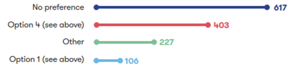
Figure 10-1: Numerical breakdown of responses to question 17a
A total of 1,353 respondents shared a range of views on maintaining connectivity between Harston and Newton. Of these respondents, 45% expressed no preference, whilst 30% were in favour of providing a connection via London Road (Option 4). A smaller percentage of respondents, 8%, opted for diverting Newton Road to the south-west (Option 1), whilst 17% of respondents indicated ‘Other’.
We also provided respondents with the opportunity to provide comments about this proposal; these are summarised in the table below.
|
Sub-theme |
Feedback summary |
|
General feedback |
Several respondents supported both proposals (Option 1 and Option 4) for maintaining connectivity between Harston and Newton, whilst a small number of respondents expressed support for the most cost-effective option without a specific preference for either Option 1 or Option 4. Some respondents opposed both options and emphasised the importance of maintaining direct connectivity between Harston and Newton. Respondents noted that the proposed realignment of London Road and Shelford Road, would require significant earthworks that were described as disproportionate for the rural setting. Concerns were raised by several respondents about the severance of the current direct road link between Harston and Newton, with respondents opposing the closure of Newton Road and the Harston level crossing due to potential negative impacts on community connectivity. Specific concerns were raised about disrupted access to schools, doctors' surgeries, and shops, access to the Thriplow recycling centre, as well as increased journey times and congestion on the A10. Mitigation suggestions included ensuring that the level crossing remains open or creating a tunnel to avoid adverse impacts on the communities of Harston and Newton. This included suggestions to provide a school bus service for Newton children attending Harston and Newton Community Primary School to minimise educational impacts. Alternative suggestions for maintaining connectivity between Harston and Newton included retaining the current road link (Station Road/Newton Road) or moving the railway alignment further west. There were also suggestions to construct an underpass or road bridge, providing a footbridge for pedestrians and cyclists and ensure active travel paths are segregated in any road realignment. Additional comments recommended implementing both Option 1 and Option 4 or relocating the Shepreth Branch interchange, while others suggested that the Foxton level crossing could be a preferred route rather than Option 4. Respondents called for a review of the location of Hauxton Junction alongside recommendations to explore other additional or alternative approaches to maintain connectivity. There was also emphasis on the need to avoid or minimise environmental and visual impacts, such as the removal of hedgerows and trees, while preserving the rural character of the area. |
|
Option 1 - General feedback |
Respondents expressed a range of views about the impact of Option 1 on the local area. Several respondents supported Option 1, with a small number citing its potential to improve connectivity when compared to the current road. They also noted that this option could reduce traffic through Harston High Street and improve access for local farms and surrounding villages. One respondent also suggested that Option 1 could be less disruptive than Option 4 for local residents and may be a safer option. In contrast, concerns were raised by a small number of respondents about its potential impact on Harston’s character. Several respondents were concerned about the severance of land and properties getting cut off and a few respondents also thought that the drainage designs weren’t clear enough. There were also objections to the inclusion of specific land parcels for mitigation or construction purposes, with suggestions to reconsider their use. Further comments questioned whether the cost of constructing a new road was proportionate to the needs of a small village. |
|
Option 1 - Traffic and connectivity |
A small number of respondents supported Option 1 citing that it would maintain access to key amenities such as the doctors’ surgery, school, and a church in Harston. They also felt that it would offer a more direct route for Newton residents to access these facilities. However, several others noted that Option 1 could increase traffic on the A10, leading to congestion and safety risks, particularly at the proposed junction where turning right onto the A10 would be difficult. Several respondents also raised concerns about the potential for increased traffic through Newton, particularly at the already congested five-way junction. Concerns were expressed by several respondents about the impact on active travel routes, with respondents noting that Option 1 may not adequately provide a safe active travel route due to fast traffic. A few respondents argued that the proposed diversion would significantly increase journey distances and times which could impact safety and practicality for schoolchildren, cyclists, and pedestrians. One respondent highlighted that the additional distance and the design of the ramps could make regular use of the footpath challenging, particularly for families with young children. |
|
Option 1 - Environmental impacts |
While one respondent acknowledged that Option 1 would provide opportunities for large-scale landscaping associated with the new road, there were also concerns about the potential visual dominance and noise from the proposed high embankment and bridge. It was noted that the visual impacts of Option 1 would also impact the setting of the listed Baggot Hall, including the loss of gardens, large trees, and historic structures. Broader environmental concerns raised about Option 1 included potential impacts on the chalk landscape, and disruption to productive arable land. Further concerns were raised about the impact on the green belt and countryside including criticism from a small number of respondents who emphasised the potential impact of this option on rural character. There was particularly concern around Newton Road, which they noted currently enjoys a tranquil setting surrounded by wildlife habitats such as badger setts, bats, and deer. |
|
Option 4 - General feedback |
Many respondents highlighted the active travel benefits of Option 4 and several others supported this option for its use of existing infrastructure, reduced land take, and lower environmental impact compared to Option 1. It was seen as a more cost-effective and less disruptive solution that Option 1, including a small number of respondents who noted that it would avoid the construction of a lengthy new road across open countryside. In contrast, several respondents believed Option 4 would result in negative impacts on local connectivity and the environment, including one respondent who described this option as complicated. Specific concerns raised included a small number of respondents who noted the potential for increased traffic on local roads and safety risks on London Road for cyclists and pedestrians. Some respondents suggested that the proposed active travel route should be built in advance of the level crossing closure while others proposed that the path should be separate from the road to enhance safety and maintain a rural character. Some respondents questioned the utility of the active travel route, citing current low usage, and raised issues about increased journey times and distances for cyclists. It was also suggested that the proposed active travel route should include a buffer of trees or hedgerows for safety and environmental benefits. There were further concerns from a few respondents about the impact on local residents due to noise, pollution, and changes to property access. Comments also raised the potential for Option 4 to conflict with local plans by opening land on green belt up for future development One respondent queried who would take on the maintenance responsibilities for proposed infrastructure such as footbridges, cycle tracks, and balancing ponds. |
|
Option 4 - Traffic and connectivity |
Several respondents expressed a preference for Option 4 due to its potential to keep traffic local with the option to avoid the A10. Support for this option also included several respondents who noted that it would provide a safer walking and cycling route for children travelling to Harston and Newton Primary School and reduce traffic on Harston Road, which was considered dangerous. A few respondents also noted that this option would maintain access to the doctors' surgery in Harston. Concerns were raised by a small number of respondents about the increased journey distances and times for both pedestrians and vehicles, including several who were particularly concerned about the potential for increased traffic congestion on London Road and the A10. A few others expressed concerns about the potential for increased traffic through village centres, including safety concerns for children near play areas and village greens. One respondent questioned the timing of the proposed changes, with some raising concerns that the new connection would only be provided after the railway works are completed, leaving a gap in connectivity during construction. Suggestions included maintaining the existing road connection, providing a school bus for children in Newton that attend the primary school, and ensuring that active travel routes are prioritised and well-integrated with existing infrastructure. Respondents also proposed alternative solutions to maintain connectivity between Harston and Newton, such as a bus-only link to reduce vehicular traffic. |
|
Option 4 - Environmental impacts |
Several respondents expressed a preference for Option 4, citing reduced environmental and visual impacts as the road would use the route of the Shepreth Branch Line track. A small number of respondents acknowledged that Option 4 would preserve more of the countryside, reduce land take, and avoid the need for a new road across farmland west of Newton. One respondent raised concerns about the potential loss of beech trees along London Road while another respondent highlighted that Option 4 performed slightly worse than Option 1 in air quality assessments and suggested collaboration with local partners to implement active transport infrastructure to mitigate this. A small number of respondents highlighted that Option 4 may discourage walking between communities, potentially increasing road traffic and pollution. A few comments further raised the potential for increased noise and pollution levels for nearby residents due to the proposed new road connection. |
10.4 Hauxton Road level crossing closure
The question we asked
We asked respondents to tell us to what extent they support us providing an additional footbridge to the east of the Hauxton Road level crossing. The feedback we received is shown in Figure 10-2.
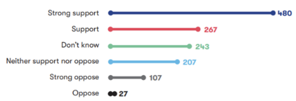
Figure 10-2: Numerical breakdown of responses to question 19a
A total of 1,331 respondents shared their views on this topic. Of these respondents 56% of respondents expressed support for the additional footbridge, with 36% strongly supporting and 20% supporting the proposal. In contrast, 10% opposed it, including 8% who strongly opposed. A further 34% were either unsure or neutral, selecting ‘Don’t know’ or ‘Neither support nor oppose’.
We also provided respondents with the opportunity to provide comments about this proposal; these are summarised in the table below.
|
Sub-theme |
Feedback summary |
|
General feedback |
Several respondents supported the Hauxton Road level crossing closure, with a small number citing improved safety and a few highlighting reduced travel times. The new road bridge (over the railway west of Little Shelford) was welcomed by a few respondents as a means to maintain connectivity between Hauxton and Little Shelford. Several others opposed the level crossing closure due to concerns about increased traffic on alternative routes, such as London Road in Harston, and the potential for congestion and bottlenecks. As an alternative, it was suggested that the level crossing could remain operational with upgrades such as full barriers, CCTV, and obstacle detection. Some respondents noted that the current level crossing causes minimal delays and questioned the necessity of its closure, suggesting that the data justifying the closure was flawed. To mitigate the impact of the closure, respondents emphasised the need for traffic calming measures, footpaths, and cycleways with physical barriers between cycling lanes and vehicle lanes on affected roads. |
|
Active travel and connectivity |
Respondents called for measures to mitigate the closure of the Hauxton Road level crossing to ensure it does not impede local connectivity. Respondents raised concerns about the proposed closure, several highlighted its impact on community access to amenities, and several others raised concern about the impact on active travel. They noted that the closure could sever links between Hauxton and Little Shelford, increasing travel distances and reliance on cars. Respondents emphasised the importance of maintaining access for pedestrians, cyclists, pushchairs, wheelchairs and mobility scooters particularly for elderly residents, and those accessing shops and doctors’ surgeries. The need for a direct route to avoid long detours was highlighted, along with the importance of ensuring the road bridge is designed to support active travel. |
|
Footbridge |
Respondents expressed a range of views on the proposed footbridge to the east of Hauxton Road level crossing. A large number of respondents expressed support for the proposal, citing its benefits in maintaining direct connectivity between Little Shelford and Hauxton, encouraging active travel and providing access to schools, shops and community facilities. Some other respondents questioned the necessity of the footbridge given the proximity of a new road bridge and suggested retaining the level crossing instead. Concerns were also raised by several respondents about the potential negative impact on the environment and the privacy of nearby properties. Some respondents suggested moving the crossing point further from Hauxton Road while others suggested screening the bridge on the southern side with trees and using movement-activated lighting for safety. Respondents also suggested that the proposed new road bridge could provide adequate connectivity for pedestrians and cyclists and highlighted that the footbridge may be of low demand as young people don’t use that route to walk to school. Usability concerns were raised by a small number of respondents for those with prams or wheelchairs, along with potential safety risks that were noted by a few respondents. Lowering ramp gradients or adding steps to improve usability was suggested by respondents. Some respondents were also keen to emphasise that the footbridge needs to be constructed in a way that avoids cyclists having to dismount, whilst some others proposed alternative solutions, such as an underpass or constructing a pedestrian/cycle tunnel under the railway with ramps for accessibility. Concerns were raised by a few respondents about the visual impact of the bridge, whilst a few other respondents also raised concerns about the impact on agricultural access and suggested ensuring the bridge does not block access to agricultural land or fields. One respondent commented on the potential for increased noise pollution during construction. |
10.5 Newton footbridge
The question we asked
We asked respondents to tell us to what extent they would support an additional footbridge between Newton and Harston to maintain connectivity between these two communities. The feedback we received is shown in Figure 10-3.
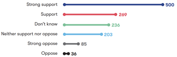
Figure 10-3: Numerical breakdown of responses to question 18a
A total of 1,329 respondents shared their views on this topic. Of these respondents, 58% of respondents expressed support for the proposed footbridge between Newton and Harston, with 38% strongly supporting and 20% supporting the proposal. In contrast, 9% opposed it, including 6% who strongly opposed. A further 33% were either unsure or neutral, selecting ‘Don’t know’ or ‘Neither support nor oppose’.
We also provided respondents with the opportunity to provide comments about this proposal; these are summarised in the table below.
|
Sub-theme |
Feedback summary |
|
General feedback |
A large number of respondents supported the proposal to provide a new footbridge for pedestrians and cyclists east of the existing Harston level crossing. They highlighted its importance for maintaining connectivity between Newton and Harston, enabling active travel, and providing access to local services such as schools, shops, and medical facilities. Respondents emphasised the need for the bridge to be accessible for wheelchairs, mobility scooters, and cyclists without requiring dismounting or navigating steps. One respondent also suggested that there should be adequate separation between pedestrians and cyclists on the bridge, and that design features should prioritise safety and accessibility, including the use of non-slip tactile paving and well-designed barriers that do not pose risks to users. Concerns were raised by some respondents about the increased travel distance and travel time between Harston and Newton caused by the proposed footbridge location. There were suggestions to place the bridge closer to the existing level crossing to minimise travel distance. Concerns about the usage of the proposed footbridge were also raised, with some respondents questioning whether it would be value for money, or whether implementing it is justified. Some respondents proposed alternative solutions, such as an underpass or retaining the existing road connection with a bridge. A small number of respondents were critical of the footbridge’s potential visual impact and it being unsuitable for some users. Suggestions were made to improve the design and location of the bridge to better serve the community, including connecting it to existing paths and ensuring it is well-landscaped. |
10.6 Hayes level crossing closure
|
Sub-theme |
Feedback summary |
|
Connectivity
|
While one respondent expressed support for the crossing of Hayes level crossing as long as it would shorten journeys, a small number of others expressed opposition to the proposed permanent closure of the level crossing. They cited concerns about loss of connectivity between Harston and surrounding villages, longer journey times, and potential negative impacts on local services such as the primary school. They also warned that closures could lead to increased heavy goods vehicle traffic through villages, causing noise and air pollution. Comments also questioned the need for new infrastructure, noting that existing roads already serve the same purpose. One respondent raised that losing crossings like Harston and Newton would be devastating for local communities. |
10.7 Shepreth Junction and West Anglia Main Line
|
Sub-theme |
Feedback summary |
|
West Anglia Main Line track layout |
The positioning of the new tracks on the western side of the existing tracks was welcomed by a few respondents for minimising environmental and infrastructure impacts, such as on the Nine Wells chalk springs and the DNA cycle path. A few others supported the addition of two tracks and the use of bidirectional signalling, citing benefits such as increased capacity, improved service performance, future rail demands, regional economic growth and operational optimisation for both lines. Some respondents questioned the necessity of a four-track corridor, with dynamic timetabling highlighted as a potential alternative to address capacity issues. A small number of respondents expressed concerns about environmental damage to fields east of the A1301, noise pollution for residents near Cambridge station, and safety implications of placing new tracks next to the Guided Busway. Respondents also highlighted the importance of protecting environmental features such as Nine Wells nature reserve and Hobson’s Brook and ensuring that freight operations are not compromised. |
|
Shepreth Junction modifications |
Respondents recommended widening the DNA Path and supported the proposal to widen the Nine Wells underbridge to accommodate pedestrians, cyclists, and equestrian users. Respondents suggested the need to include provision for cyclists without the need for dismounting as part of the proposals to replace the Great Shelford Footpath 1 footbridge. One respondent opposed a grade-separated junction at Shepreth Junction, citing potential adverse impacts on residents of Hauxton, Great Shelford, and Little Shelford, while a few others supported grade separation to increase capacity and efficiency. Concerns were raised by one respondent about the visual impact of an elevated Shepreth Branch Royston Line over Harston Tunnel, with suggestions to move the Shepreth rail connection 500 yards (457 metres) south from another respondent. Concerns were also raised about the timing of the proposed works to Shepreth Junction, with some respondents requesting they are carried out at the same time as the major works for Cambridge South station. |
10.8 Infrastructure features
|
Sub-theme |
Feedback summary |
|
Chapel Hill Tunnel |
A number of respondents thought there should be further work around Chapel Hill to determine whether the tunnel could be extended to reduce visual and archaeological impacts and whether access to the tunnel for maintenance could be amended to reduce its impacts on the surrounding area A few respondents supported the inclusion of a tunnel as an improvement over embankments and cuttings, specifically citing reduced visual and environmental impacts, protection of bat flight paths, and preservation of the area's cultural and archaeological significance, including Bronze Age barrows and the historic Money Hill Cemetery. Some respondents highlighted the need for careful design to avoid damage to aquifers, chalk streams, and the geological Site of Special Scientific Interest at Barrington Chalk Pit. The potential for contamination of water supplies and the impact on local businesses and residents during construction were highlighted by several respondents as issues. Concerns were also raised by several respondents about the potential loss of high-grade agricultural land and disruption to local farming operations. Some respondents requested mitigation measures to preserve the defining views of Cambridge from Chapel Hill, whilst others suggested that the tunnel should be longer to minimise noise and reduce the depth of cuttings. Respondents also suggested relocating tunnel portals further from residential areas to mitigate noise and air pollution. Others emphasised the need for additional noise mitigation at tunnel portals. The use of tunnel boring machines instead of mining techniques was also suggested in order to expedite construction and reduce environmental impacts. Some respondents questioned the necessity of the tunnel and suggested alternative routes, such as a northern approach to Cambridge along the A428 corridor. |
|
River and stream crossings and viaducts |
Several respondents raised concerns about the environmental and ecological impacts of the proposed viaducts over Bourn Brook and the River Rhee including potential risks to water quality, biodiversity, and local wildlife. Respondents also raised concerns that the use of the line for freight would worsen countryside views and increase noise and pollution. Suggestions included mitigating visual impact by routing the train line in a trench over Bourn Brook, using a siphon to maintain water flow, and continuing the trench alignment to the A603 to reduce landscape disruption. It was also proposed that a road-over-rail crossing be used at A603 instead of large embankments and under-bridge designs, as this would require less valuable agricultural land and offer multiple benefits. Respondents also proposed constructing road over rail crossings to avoid high embankments, which were criticised for their potential to disrupt habitats, increase flood risks, and cause noise pollution. There were further suggestions to enhance the River Rhee with gravel placement, tree work and floodplain connections as well as building a footbridge across the river. |
10.9 Environment and sustainability
|
Sub-theme |
Feedback summary |
|
Air quality and emissions |
Several respondents raised concerns about pollution caused by freight trains and highlighted the emissions from idling diesel engines in passing loops. The potential increase in traffic and car use due to road diversions and level crossing closures was seen by several respondents as likely to exacerbate air pollution. Strategies such as planting trees along the railway to mitigate pollution was suggested. The proximity of the railway to residential areas and schools was noted, with several respondents specifically highlighting the proximity of the proposed alignment to Comberton Village College. Several respondents raised concerns about the health impacts of increased air pollution and dust on students, staff, and the wider community. There were also calls for guarantees and reassurance about the protection of local residents from air pollution during construction. Additionally, a few respondents expected the emissions (including electromagnetic interference) to have an impact on sensitive research facilities, such as the Mullard Radio Astronomy Observatory. |
|
Operational noise and vibrations |
A large number of respondents highlighted the potential for increased noise pollution from freight and passenger trains, especially at night, and the idling of diesel freight train engines in passing loops near residential areas such as Harston. Specific concerns were raised by many respondents about the impact on students at Comberton Village College, where noise could hinder learning and disrupt exams, especially for neurodiverse students. Elevated structures like embankments, viaducts, and overpasses were noted by many to amplify noise, affecting tranquil rural areas like Harlton, Haslingfield, and the Eversdens. The impact on local residents' quality of life, including the ability to enjoy outdoor activities and maintain peaceful living environments, was noted by several respondents. There was support for implementing noise screening measures along the route, including screening the track with tree planting and extending the length of tunnels to further reduce impacts. The use of noise attenuation bunds was recommended to be implemented near significantly affected receptors in addition to suggestions to purchase farmland to create a woodland noise buffer. Respondents questioned the adequacy of proposed noise mitigation measures and requested clear communication about noise levels, independent noise surveys, and assurances regarding the mitigation of noise and vibration impacts. The need for detailed studies on noise impacts and effective mitigation measures was emphasised, including compliance with local policies like South Cambridgeshire District Local Plan policy TI/7. |
|
Water resources and flood risk |
Many respondents raised concerns about the potential for increased flooding and water resource issues resulting from the project. A few respondents were critical that the proposed viaducts would cross floodplains, such as those of the Bourn Brook and River Rhee. Respondents also asked EWR Co to ensure that underpasses are adequately drained to prevent flooding, referencing existing issues with underpasses in the area. Several respondents expressed concerns about the potential for embankments and additional stormwater runoff to exacerbate existing drainage problems, particularly in areas like Harston, Comberton, and the A603 floodplain. Concerns were also raised about the adequacy of existing sewage and drainage infrastructure to handle additional runoff, with specific references to areas like Lowfields and Haslingfield. Specific concerns were raised by several respondents about the risk of contamination and disruption to chalk aquifers, which are critical for water supply and support rare chalk streams, such as the River Rhee, Hoffer Brook, and others in the region. The importance of protecting fragile ecosystems was stressed, including chalk streams and associated habitats, and ensuring that hydrological changes do not negatively affect water supply or biodiversity. Additionally, respondents highlighted the need for further studies and evidence to assess the environmental impact, particularly on aquifers, chalk streams, and heritage watercourses like Hobson’s Conduit. Respondents questioned whether the plans adequately considered the high-water table and existing surface water issues. The need for careful design and implementation of attenuation measures was emphasised, such as balancing ponds to manage runoff. Issues about the safety, maintenance, and potential contamination of these ponds were also voiced by several respondents, as well as their impact on local ecosystems and wildlife. Suggestions included ensuring no increase in surface water flow, maintaining natural irrigation channels, and considering alternative designs, such as trenches with flood mitigation measures, to reduce flood risks. Respondents also highlighted the need for careful management of construction activities near the pipes connecting the Eversdens to the pumping station. |
|
Biodiversity and nature conservation |
A large number of respondents raised concerns about the environmental and ecological impacts of the proposed route, particularly on biodiversity and nature conservation. Issues highlighted included the potential loss of ancient woodlands, hedgerows, and mature trees, including areas such as Eversden and Wimpole Woods SAC, which are critical habitats for protected species like Barbastelle bats. The effectiveness of proposed mitigation measures was questioned, with some respondents questioning the effectiveness of bat crossings, green bridges, underpasses, and viaducts. Several respondents raised additional concerns regarding the impact on other wildlife species, such as badgers, otters, deer, and red-listed bird species, as well as damage to high-value habitats, including nature reserves, local farms, chalk grasslands, wildflower meadows and the Bourn Brook. The use of embankments and viaducts was criticised by several respondents for their impact on wildlife movement and causing habitat fragmentation. The impact on chalk streams, grassland, and farmland was also noted, with respondents emphasising the risk of irreversible damage to ecosystems and the loss of arable land. Respondents questioned the adequacy of ecological surveys and monitoring strategies, suggesting that the data used might be outdated or insufficient. There was also disagreement about potential habitat creation in areas already managed for conservation, with some respondents suggesting that such measures would not compensate for the loss of established ecosystems. Concerns were also raised by several respondents about the long-term recovery of affected flora and fauna, the potential contamination of farmland, and the inadequacy of Biodiversity Net Gain measures proposed. Respondents requested that the project achieve a Biodiversity Net Gain of at least 20%, with some suggesting a target of 50%, and emphasised that gains should be local to affected areas. Calls were made for environmental assessments to ensure transparency. Respondents also requested the preservation of green spaces, and enhancement of biodiversity in the green belt area. |
|
Landscape and heritage |
While some of the impacts of the project on landscape and heritage were criticised, a few respondents showed support for mitigation proposals such as tree planting and creation of green spaces or lowering the railway elevation between Comberton and Harlton to reduce visual impact. However, there was significant concern that the project would cause irreversible damage to the countryside. Several respondents specifically raised concern about damage to Bronze Age burial mounds on Chapel Hill and Money Hill, with suggestions to preserve these sites in situ. Concerns were expressed by several respondents about the impact on historical sites such as the Grade I listed St Mary’s Church in Haslingfield, the Greenwich Meridian Marker, the ancient Lot Way trackway, and the moated complex near Fryers Cottage. A few respondents noted potential damage that the project may cause to listed buildings, including shallow foundations in Haslingfield, and a small number also viewed the disruption to the character of historical villages like Harston, Newton, and Harlton as concerning. The proposed moving of the A603 junctions with Comberton Road and Washpit Lane was similarly flagged by a few respondents as an issue, with apprehensions that this would destroy the ancient heritage of the area. The need to minimise the impact on historical villages in South Cambridgeshire was emphasised. Some respondents proposed that redesigning cycle and pedestrian bridges in the area would help to reduce the overall visual impact. The proposed Hauxton footbridge was specified as an issue by a few respondents who were concerned that it may negatively impact the visual appearance of the village. Additional concerns given by several respondents included the loss of green belt land, open spaces, agricultural land and views (such as those from Chapel Hill), as well as impacts on ancient routes like Mare Way. The visual impact of high embankments, viaducts, and bridges, particularly near Harlton, the Eversdens, and the viaduct over the River Rhee, was noted as an issue, with suggestions to minimise impact through alternatives such as deeper cuttings, tunnels, or rerouting the line. Respondents also expressed concerns about the siting of balancing ponds and woodland creation, suggesting these features were overly engineered and out of context with the surrounding landscape. |
10.10 Traffic and transport
|
Sub-theme |
Feedback summary |
|
Connectivity |
Many respondents raised concerns about the impact on connectivity between villages, including Newton, Harston, Harlton, Haslingfield, and the Eversdens, a few of whom specifically noted that closures such as Newton Road would increase travel time, limit access to Harston and negatively impact community cohesion. Access to facilities in Comberton was also highlighted by a small number of respondents as likely to be disrupted. Several respondents believed that the project would increase car dependency due to the lack of public transport connections to and from stations. Several respondents perceived a lack of direct benefits to villages like Harston, Haslingfield, and Comberton due to the absence of proposed stations, while causing disruption to daily life, community links, and connections with essential services. Some of these respondents also felt that the absence of local stations would mean a failure to improve local connectivity and reduce congestion. |
|
Access to stations |
A lack of new stations between Cambourne and Cambridge South was a concern for several respondents. It was felt these areas would not benefit as they are already poorly served by public transport and would require travel to stations in Cambridge, Royston, or Cambourne in order to access the rail service. Respondents suggested additional funding be allocated to address access issues at stations, and that stations should be included at Comberton, Harston and Hauxton to improve connectivity. |
|
Active travel and public rights of way |
A large number of respondents supported footbridges and active travel routes to improve connectivity, particularly between Newton and Harston, and Hauxton and Little Shelford. Respondents emphasised the need to maintain direct, safe, and high-quality active travel routes during and after construction, with minimal diversions and well-maintained paths. The importance of integrating active travel into the design and compliance with design standards like LTN 1/20 was also highlighted. Several respondents raised concerns about the impact of the rail proposal on active travel and public rights of way, citing issues such as increased journey distances and safety risks. This included loss or disruption of routes used for recreation. Several respondents also noted that the closure of level crossings and new infrastructure could force users onto busier roads, discourage walking and cycling, and increase car dependency. Furthermore, concerns were expressed by several respondents about steep gradients and accessibility of proposed footbridges, a small number raised concerns about disruption to popular routes like the DNA cycle path, and many commented on insufficient provision for cyclists, disabled users, and equestrians. Respondents made suggestions which included providing permanent footpaths and cycleways along the railway, providing safer routes for walking and cycling (e.g. Newton Road), installing dual-purpose cycle tracks/footpaths with embedded ground lights, a cycle route around the Bourn Brook area and ensuring bridges and underpasses are wide, well-lit, and accessible. Where possible, respondents felt there was a need to provide better connectivity between villages and key destinations like schools, shops, and employment centres, and to promote active travel to align with government policies and environmental goals. Respondents also supported investing in the proposed Melbourn Greenway, with a request to ensure that the walking and cycling route is not affected by the proposals. |
|
Road journeys |
Several respondents noted that the closure of level crossings, such as at Harston, Hauxton, and Newton, would funnel traffic onto fewer roads, increasing congestion. It was felt by several that the closure of roads like Newton Road and Station Road would be detrimental to village connectivity, with longer detours affecting access to schools, workplaces, and essential services. It was also noted by a small number of respondents that farm traffic would likely face longer journeys. Several respondents also raised several road safety related matters in their feedback, including concerns about high-speed vehicle entry into Newton from Harston Road, safety risks for cyclists on the proposed railway bridge. The proposed Harlton crossing was identified as a concern by one respondent who highlighted that the proposed overbridge could worsen existing glare issues on an east–west road, increasing safety risks. A small number of other respondents raised the risk of reduced visibility and accidents on the proposed overbridge to Haslingfield and the embankment over the A603. The Newton and Hauxton Road footbridges were supported by many respondents, some of whom highlighted the safety benefits of separating pedestrians and cyclists from traffic. A signal-controlled crossing on the A10 was also suggested for safety. Suggestions included the provision of footpaths and cycleways along Newton Road to connect to the proposed overbridge, keeping Newton Road open by relocating Hauxton Junction, implementing traffic calming measures to manage increased traffic volumes and a bridge at Foxton level crossing to mitigate traffic impacts. For Granham’s Road, there were suggestions from some respondents to ensure the cycle path crosses the road near the level crossing, to provide enhanced visibility . Others asked to avoid diverting the cycle path onto Granham’s Road on safety grounds. Other suggestions included the provision of a signal-controlled crossing on the A10, plus maintaining flat road designs near schools for improved visibility and the safety of children. |
|
Rail journeys |
A small number of respondents supported proposals to increase capacity, but emphasised the importance of ensuring these upgrades do not disrupt existing services. Questions were raised about the impact on existing rail capacity, particularly on the Hitchin to Cambridge route and the West Anglia Main Line, with assurances requested that the project would not negatively affect current service patterns or future growth. Respondents felt that the proposed route, particularly between Oxford and Cambridge South, was not the most direct option. This included suggestions that a northern approach to Cambridge would deliver quicker journey times. A few respondents also expressed concerns about potential delays along the proposed route during peak travel hours and highlighted the lack of first- and last-mile connectivity for certain areas, such as the Eversdens. |
|
Freight |
Many respondents were concerned about the impact of running freight services through the area, several particularly highlighted noise and air pollution as a worry. Many respondents were concerned about the potential 24/7 operation of freight trains, causing disturbances in the countryside and to nearby residential areas. Respondents requested that EWR Co reassess the approach to freight, including the removal of freight transportation from proposals, entirely to allow focus on passenger services and consideration of alternative routes for freight. Freight loops, where trains can idle for extended periods, were seen as a source of additional noise and air pollution, particularly near Harston and other villages and caused concern for a few respondents. The proposed route into Cambridge was criticised for routing freight through Cambridge and nearby villages, with suggestions that a northern route into Cambridge would better mitigate these impacts by bypassing these communities. Disruption to students at Comberton Village College was also raised as a concern by several respondents due to the proximity of the railway and potential freight operations. One respondent also questioned the financial viability of the freight component, especially given recent changes in freight patterns at the Port of Felixstowe and called for clearer estimates of freight traffic and its impacts. |
|
Train services |
Concerns were raised about overcrowding during peak times, with longer trains suggested to address the issue. The need for adequate and fit-for-purpose cycle storage on trains was emphasised, with the trains on the Marston Vale line being referenced by respondents as a good example of this. Respondents also suggested use of a Tram-Train, suitable for street running and as a low-cost feeder line without requiring a tunnel. Affordability of train tickets was questioned, with respondents feeling the project would only be worthwhile if ticket prices were not too expensive compared with travel by car. |
10.11 Construction and logistics
|
Sub-theme |
Feedback summary |
|
Construction timeline and cost |
Several respondents expressed a desire for the project to progress quickly, emphasising the need to avoid delays caused by feasibility studies, further consultation, and bureaucratic processes. Respondents also noted the growing demand for the line due to developments like the Biomedical Campus and Cambridge South station, urging for a speedy and cost-efficient build. Concern was also raised about the construction timeline, with a small number of respondents noting that works could last up to a decade. Some highlighted the dependency on moving the current line and closing level crossings, which could leave villages without road connections temporarily. Some also questioned why the northern approach to Cambridge was no longer being considered, citing its potentially lower construction costs, quicker build time, compared to the southern approach. |
|
Environmental impacts of construction |
Many respondents raised concerns about the environmental impacts of construction and disruption to daily life, particularly in villages such as Harston, Harlton, Haslingfield, Hauxton, Newton, and Little Shelford. Many respondents noted that construction activities, including embankments, tunnels, and associated compounds, would cause habitat loss, noise, light pollution, and vibration, further threatening wildlife. Concerns were expressed by many respondents about the effects on students at Comberton Village College and Harston and Newton Community Primary School, including disruption to learning and health risks from noise and air pollution. Additionally, some respondents requested that construction works should be avoided and minimised during critical school periods, such as during exams. Other respondents also advocated for limiting noisy construction activities to daylight hours. Several respondents highlighted the impact of construction compounds near residential areas, such as Haslingfield, Harlton, and Wells Close, on noise, air quality and environmental impact. Respondents requested that EWR Co should implement effective noise and dust suppression measures to help mitigate this, in addition to buffer zones around construction sites. Concerns were also raised by several respondents about the long-term productivity of farmland, potential contamination of land and watercourses, and specific hazards such as historical mustard gas contamination at Marsh Close. Mitigation measures to reduce the impact of construction suggested by respondents included conducting independent noise and air quality assessments, providing acoustic walls or fences, relocating construction compounds further from residential areas and constructing the railway in a trench to reduce earth movement and environmental disruption. |
|
Traffic and diversions |
Many respondents raised concerns about traffic disruption and diversions during the construction phase of the project, highlighting issues such as increased congestion and safety risks (including potential delays to emergency services) due to construction traffic on already congested and poorly maintained roads, including the A10, A603, and B roads in affected villages. To address this, it was suggested that EWR Co should build temporary access roads for construction traffic to avoid local roads and that EWR Co should avoid the simultaneous closure of multiple access roads to villages. Additionally, it was proposed that construction traffic should be restricted to major roads, avoiding residential areas, and should use haul roads or major routes like the A10 or A603. Concerns were expressed by several respondents about road closures, with particular apprehensions about short-notice closures. Several respondents raised concerns about the re-routing isolating villages like Harlton, Haslingfield, and Harston and potentially impacting access to schools, medical facilities, shops, and other essential services. Specific concerns were raised by several respondents about the impact on school routes, particularly for Comberton Village College, and the ability of students and staff to travel safely and on time. Several respondents noted potential damage to local infrastructure, worsening road conditions, which could be hazardous for cyclists, pedestrians, and horse riders. Past experiences in Buckinghamshire were highlighted, where similar projects caused road and verge damage and difficulties in controlling heavy goods vehicle speeds. Respondents emphasised the need for strict compliance with speed limits, traffic calming measures, regular monitoring of traffic, and maintenance of local road surfaces during the construction period. The A10 south of Cambridge was specifically identified as dangerous due to high traffic volumes. The need to ensure that road diversions are operational before closing existing level crossings was a suggestion. Respondents also suggested that the project should fund independent road condition surveys, repair road defects caused by the project on an ongoing basis and ensure that local bus routes remain unaffected. |
|
Construction safety |
Several respondents raised concerns about the safety and wellbeing of residents during the construction of the railway, particularly in Harston village and its surrounding areas. There were apprehensions from many respondents about the dangers posed by construction activities, including noise, dust, and construction vehicles. Concerns were also raised by many respondents about the safety of children cycling or walking to school, with specific mention of the road between Comberton and Harlton needing to remain open for safe and direct access between these communities. Respondents flagged the importance of maintaining and preserving cycle paths and public rights of way during and after construction. The proximity of construction to schools and historic villages like Haslingfield, with its narrow roads, tight bends, and listed properties, was noted by several respondents as a risk for accidents and property damage. Respondents also suggested providing safe viewing areas for locals to observe construction and installing information boards to enhance understanding of the works. |
|
Construction compounds |
Several respondents raised concerns about the construction compounds proposed along the route, particularly their proximity to residential areas, schools, and community facilities. Specific issues included the impact on Comberton Village College, where compounds were planned near sports areas and playing fields, potentially affecting students' health and learning due to noise and dust. Respondents suggested relocating these compounds further away and limiting dust creating activities in these areas. Apprehensions were also expressed by several respondents about the compounds near Haslingfield, Harlton, Harston, and other villages, with respondents highlighting issues such as noise, air, and visual pollution, as well as the potential for long-term disruption to the countryside and local communities. The proximity of compounds to homes, such as those on Wells Close in Haslingfield, was deemed unacceptable by several respondents. There were requests for a minimum buffer zone of 150 metres from residences. Respondents questioned the placement of compounds near Harston and Newton Road and suggested alternative locations further from residential areas. Respondents requested more details on the operations and mitigation measures for pollution, noise, and disruption during the construction phase and also queried the sourcing, transportation, and storage of embankment materials. |
10.12 Community benefits and impacts
|
Sub-theme |
Feedback summary |
|
Access to jobs, education and healthcare |
Many respondents raised concerns about the project’s impact on access to schools, healthcare, and local amenities. Access to Comberton Village College, where many students rely on buses and walking and cycling routes, was particularly highlighted. A few respondents noted that the closure of Newton Road and other routes would increase travel distances for children attending Harston and Newton Community Primary School. Many respondents expressed concern about the proximity of the rail line to Comberton Village College, with worries about the disruption to students' learning, exams, concentration, health, and educational outcomes, especially for those with neurodiversity and disabilities. Many respondents voiced support for the project, citing its potential to improve commuting access between neighbouring towns. However, they emphasised the importance of maintaining connectivity between villages such as Comberton, Harston, Newton, Haslingfield, Harlton, Hauxton, and Little Shelford, which share schools, doctors’ surgeries, and other amenities. Some respondents recommended relocating Hauxton Junction further from Hauxton to preserve Newton Road connectivity, and others suggested tunnelling the railway under the road between Harlton and Haslingfield to minimise community division. A few respondents criticised the lack of a station near Comberton Village College, limiting access to education. Respondents suggested that the southern approach to Cambridge focuses on access to jobs at the Cambridge Biomedical Campus, potentially neglecting other employment areas in the city. |
|
Local economy |
A few respondents supported the southern approach to Cambridge for its potential to boost economic growth and provide long-term benefits, whilst a small number of others argued that the northern approach would better serve the science and business parks in northern Cambridge. Several respondents expressed concerns about the potential negative impact of the project on the local economy, including disruption to local businesses and farms and some respondents believed that the project would not provide economic benefits to the local area. Several respondents noted that the construction and operation of the railway could lead to road closures, increased congestion, and longer travel times, adversely affecting local businesses. Concerns were also raised by many respondents about the loss of agricultural land due to the land take associated with the project, with respondents highlighting that the quality and productivity of farmland could be significantly reduced. A small number of respondents also mentioned that businesses reliant on connectivity, such as those in Newton and Harston, could face financial challenges due to severed connections and increased travel costs. One respondent raised concerns about the impact on the River Rhee, a chalk stream with significant economic value as a tourist destination, and a few highlighted the potential interference with the Mullard Radio Astronomy Observatory, which is of international importance. Respondents suggested that the project should consider relocating the Hauxton Junction to minimise disruption, maintaining sensitive access for farms and businesses, and providing a fund to support businesses severely affected by the Project. Concerns were also raised about the financial justification of the project, particularly in light of financial constraints and the lack of updated usage forecasts to reflect post-COVID changes in travel patterns. |
|
Local communities |
Many respondents raised concerns about the perceived lack of community benefits from the project. Many stated that the route would sever community connections and a few were concerned that the project could disrupt daily life. Several respondents highlighted that the project could negatively impact local businesses, schools, and amenities without providing tangible benefits, such as local stations or improved transport options. Concerns were also expressed by many respondents about disruption during the construction phase, with potential long-term impacts on quality of life, mental health, property values, and community cohesion highlighted. Respondents suggested alternative solutions, such as moving the route closer to Foxton, considering a northern approach to Cambridge, or relocating the route slightly west into a golf course to balance proximity to Toft and Comberton. There were also calls for funding from the project for community benefits such as mental health support, youth facilities, and improvements to schools and recreational spaces. There was appreciation for design elements that could benefit the local community like the inclusion of the overbridge at Harlton, the grade separation at Hauxton Junction, and the potential for through services between Oxford and Ipswich. Other respondents requested clearer communication of potential benefits, compensation for affected communities, as well as the appointment of an ombudsman to mediate between residents and construction companies. One respondent emphasised the need for a detailed social impact assessment and questioned the justification for the project without a clear business plan or tangible benefits for local residents. |
|
Safety and wellbeing |
Respondents raised concerns about the safety and wellbeing implications of the project, including several that were concerned about increased traffic. Several others were concerned for potential construction impacts, and a few respondents who were concerned about the proximity of infrastructure to residential and community areas. Several respondents highlighted risks such as potential accidents at intersections, impaired sightlines, and the safety of road users due to proposed bridges and road realignments. Specific concerns were expressed by several respondents about the safety of children near schools and recreation areas, particularly during the construction period. Several respondents highlighted the mental health impacts of the proposal, such as stress and anxiety caused by noise and disruption. Privacy issues were also raised by a small number of respondents regarding the proximity of footbridges and rail lines to homes. The safety of balancing ponds and the potential for misuse of bridges as suicide spots were also noted by a few respondents in some responses. Some respondents proposed providing segregated facilities for pedestrians and cyclists on bridges, ensuring footbridges are equipped with motion-sensor lights to enhance safety and implementing safety features for balancing ponds to prevent accidents. |
|
Impact on equality and protected characteristics |
Several respondents raised concerns about the impact of the project on local schools, particularly Comberton Village College and Harston and Newton Community Primary School, citing issues which could negatively impact students' learning, health, and wellbeing. Accessibility for disabled individuals, wheelchair users, and those with mobility issues was also highlighted by several respondents, with respondents stressing the importance of inclusive design for footbridges and cycle paths. |
10.13 Land and property
|
Sub-theme |
Feedback Summary |
|
Residential land and properties |
Many respondents raised concerns about the impact of the project on residential properties and land. Issues included the loss of green spaces, depreciation of property values, and the potential demolition of homes, particularly near Hauxton level crossing and other areas close to the proposed route. A few respondents highlighted risks to older and listed properties, such as those in Haslingfield and Newton, due to vibration from construction and road widening. Concerns were expressed by several respondents about noise, air pollution, and vibration affecting homes near the railway line and construction zones, with some respondents requesting a minimum distance of 150 metres between construction sites and residential properties. Specific issues were noted regarding access to properties, including one respondent who highlighted that equestrian facilities required large vehicle access. A few respondents also mentioned the potential loss of mature trees and the need for replacement planting. Requests were made for extending tunnels, such as the Chapel Hill Tunnel, to reduce proximity to homes, and for mitigation measures like acoustic fencing and screening. Some respondents suggested moving the route further south to minimise effects on villages like Harston and Harlton and called for EWR Co to engage with affected residents, provide detailed information on the impact of the railway, and expand compensation schemes. A small number of respondents also noted the emotional and financial stress caused by the safeguarding of land and the uncertainty around the impact of the project on their homes. |
|
Property values |
Several respondents expressed concern about the negative impact of the project on property values in the area. A few respondents highlighted that houses in Haslingfield, Harston and Harlton were already struggling to sell and noted that the uncertainty caused by the project, including safeguarding measures and the proposed route's proximity to homes, was deterring potential buyers. Many respondents raised issues with the blight, compensation, and Need to Sell schemes which were described as restrictive, vague, and inadequate. Concerns were raised by several respondents about the long-term devaluation of properties due to construction noise, vibration, air and light pollution, and the overall disruption to the rural environment. Several respondents also mentioned that the construction phase would significantly affect quality of life for residents in villages like Harston, further impacting property values. They requested clarity on construction timelines to mitigate the blight's impact and called for fair compensation for the loss of property value and saleability. |
|
Business land and properties |
Several respondents raised concerns about the impact of the project on businesses, agricultural land, and properties, including the potential loss of land and disruption to properties in Newton due to road widening and construction activities. Some respondents expressed concerns about compromised access to fields during and after construction and highlighted financial and operational challenges, with a small number of respondents highlighting impacts on Farm Business Tenancy agreements. The railway's alignment was reported to cut through large blocks of farmland, rendering significant portions unfarmable and affecting drainage, roadways, and utilities. Several respondents highlighted the loss of prime agricultural land and some noted that land returned after construction may not be viable for farming for decades. Many respondents highlighted the negative implications on food security, and one respondent raised concerns about the disruption to game shooting activities that contribute to rural income. A few respondents questioned the justification for using prime farmland for tree planting and rewilding, suggesting less valuable land be used instead. Several respondents highlighted the lack of access to severed farmland, with requests for provisions such as agricultural crossings and access routes to maintain farm operations. A very large number of respondents suggested reconsidering the route alignment, and a substantial number of respondents believed that a northern approach to Cambridge would affect fewer villages and agricultural areas. Respondents also highlighted the need for detailed consultation with affected farms to address operational challenges and compensation. |
|
Planned and future developments |
Concerns were expressed by several respondents about the potential for the project to encourage housing development in areas already facing water scarcity and traffic congestion. Some respondents suggested that the northern route into Cambridge would better align with existing and planned housing developments in Northstowe, Waterbeach, and other northern areas. A few respondents noted that the route into Cambridge could lead to the loss of agricultural land and green spaces, with some respondents expressing concern that the land used for construction might later be sold for housing development. There were objections to the route alignment in Comberton, with a small number of respondents highlighting its impact on development land. Concerns were also raised by a few respondents about the perceived lack of integration of the project with local and regional planning frameworks, including the Greater Cambridge Local Plan, and the absence of a regional plan for the 'Oxford Cambridge Arc.' Some respondents highlighted the need for infrastructure improvements to support existing and committed growth, rather than enabling further development, while others believed that a new station between Harlton and Haslingfield would support future housing developments in the area. |
1. Cambridge
This chapter presents feedback received on proposals for the Cambridge section of EWR. It runs between Addenbrooke’s Road bridge which passes over the existing West Anglia Main Line, north of Great Shelford, to the A14 bridge north of Cambridge North station, to Yarrow Road in Cherry Hinton to the East of Cambridge on the Newmarket Line. It covers approximately 8 kilometres (5 miles) and includes improvements to Cambridge station, a turnback at Cherry Hinton and a potential Cambridge East station. It also connects with Network Rail’s Cambridge South station.
A total of 1,254 responses were received about this route section.
Some responses in this section reflect views or interpretations that may not accurately reflect the proposals set out in the consultation. To understand the context behind the feedback presented, it may be useful to refer to Chapter 16 of the 2024 Consultation Document. The consultation document and other consultation materials are available on our website: eastwestrail.co.uk/consultation2024
11.1 General route section
|
Sub-theme |
Feedback summary |
|
Route alignment |
There were calls for consideration of the northern and southern routes, with many arguing that the northern route could better meet the project’s strategic objectives and provide greater benefits to the region. Many respondents expressed a preference for the northern approach to Cambridge, which they felt could be less disruptive to sensitive habitats, more cost-effective, and better aligned with existing transport corridors. It was seen as offering stronger connections to Cambridge North station, the Science Park, and other growing communities like Northstowe and Waterbeach. Some respondents suggested that the northern approach could support through services to London and Stansted Airport and avoid the need for a turnback facility at Cherry Hinton. Several respondents felt that the southern route could be a more effective option for boosting economic activity and improving connections across the region. However, other respondents felt that this route could cause disruption in and around Hauxton, Harston, Little Shelford, and other nearby villages, with limited benefits in return. There were also concerns that some villages along the route would not be directly served by stations, meaning residents may need to drive to stations, undermining the route’s ability to meet local commuter needs. Concerns were also raised about how suitable the southern route would be for freight, as trains passing through central Cambridge could cause disruption for local communities, businesses, and the surrounding environment. The northern route was seen as offering broader benefits than the southern route, including serving more people. Respondents also suggested that the northern approach would be more suitable for freight, allowing trains to bypass Cambridge entirely and connect more efficiently to destinations such as Felixstowe and Ely. and avoiding the need for freight to pass through central Cambridge. Several respondents also felt that the southern route prioritised serving the Cambridge Biomedical Campus, at the expense of wider connectivity. There were also concerns that this route could increase traffic and cause more environmental disturbance. |
11.2 Cambridge South station
While Cambridge South station is being delivered by Network Rail rather than East West Rail, we received comments relating to this which are reflected in the table below.
|
Sub-theme |
Feedback summary |
|
Connectivity |
A few respondents viewed Cambridge South station, which is currently under construction by Network Rail, as offering valuable connectivity benefits. One respondent, for example, anticipated it serving as a key interchange for journeys involving the Midland Main Line, Cambridge, and the Cambridge–Liverpool Street line. The station was also considered critical by a small number of respondents for accessing Addenbrooke’s Hospital and the Cambridge Biomedical Campus. One respondent felt that Cambridge South station would improve local traffic and transport, as fewer cars would need to travel through the city. Several respondents also acknowledged the broader role of the Network Rail project at Cambridge South station in supporting emerging communities and economic growth in the southern parts of Cambridge. One respondent expressed concerns about the accessibility of Cambridge South station during rush hour traffic. |
|
Station access and facilities |
A few respondents emphasised the importance of integrating Cambridge South station with existing roads, bus links, and active travel routes to reduce overall journey times and improve access to the station. Suggestions included bike storage, electric bike hire, and the widening of foot and cycle paths. Comments indicated that these measures could support increased footfall, particularly among students from Long Road Sixth Form College. Many respondents also called for improved facilities, such as bridges and lifts, to accommodate the volume of people expected to use the station. There was also emphasis on the need to retain and improve existing paths and to minimise closures during construction works. Respondents proposed suitable parking spaces for passenger pick-up and drop-off within walking distance of the station, with a few comments raising concerns about the current lack of parking at Cambridge South station. A small number also highlighted the inconvenience of having to drive to a park-and-ride facility and then take a bus to the station. |
11.3 Cambridge station
|
Sub-theme |
Feedback summary |
|
Station access and facilities |
Many respondents recommended an additional eastern entrance to Cambridge station, suggesting that it could alleviate congestion at the current western entrance and improve access to the east side of the city. They also highlighted the potential for an eastern entrance to connect with the Clifton Road area, the Chisholm Trail, and the underutilised Cambridge Leisure car park, which could also serve as a station car park. Several respondents welcomed the additional footbridge at the south end of Cambridge station and suggested extending it to the east side to ease overcrowding at the western entrance and improve access for travellers. Some also felt there was a lack of secondary escape routes at Cambridge station and emphasised the need for compliance with safety standards. They further urged collaboration with local authorities and alignment with local planning policies to ensure the entrance supports future growth and connectivity. |
|
Connectivity |
Some respondents emphasised the importance of Cambridge station as a key connection to London and a driver of growth in Cambridge. They also raised concerns about the impact of closing Cambridge station during upgrade works on existing train services and wider connectivity. This included concerns that the land required could disrupt the proposed Cambourne to Cambridge busway and cycle path south of the station. One respondent felt that Cambridge station is too far from the city centre to deliver significant benefits for local visitors in general. Some respondents questioned why Cambridge station would be upgraded instead of other locations such as the Newmarket Branch, Cambridge North, or Ely. Respondents also discussed opportunities to maximise future rail operations around the station and avoid costly and disruptive works after the central section of the EWR line is constructed. This included recommendations for additional infrastructure, such as provisions for freight train sidings, to enhance operational flexibility. Questions were raised about the impact of construction on existing train lines, with emphasis on the importance of maintaining connectivity to destinations like Norwich, Ipswich, and Stansted Airport, and ensuring the project supports economic growth in areas such as Newmarket. |
|
Station design |
Several respondents supported the proposed changes to Cambridge station as a way of addressing the need for increased capacity, improved access, and enhanced facilities. Some recommended making passive provision for a platform 10 or additional tracks to allow for future expansion of Cambridge station. However, they emphasised the importance of respecting the station's Grade II listed status and avoiding harm to its historical significance while developing the station layout. Respondents specifically noted the need for better access between platforms, supporting the inclusion of additional bridges within the proposals for the station. However, others suggested the incorporation of underpasses, full-length platform canopies, and clearer platform numbering to improve navigation within the upgraded station design. There were also requests for larger lifts, better cycle security, and additional waiting areas. Operational improvements were also proposed, such as swapping tracks through platforms 3 and 4, and reconfiguring the grade-separated junction at Harston to ease northbound departures. A platform and train holding space was also recommended to accommodate terminating trains. Some respondents questioned the need to extend platforms 7 and 8 at Cambridge station. Others questioned how adequate these platforms currently are for 12-car trains and asked whether extending them would offer any operational benefits without additional infrastructure, such as scissor crossings. There were also suggestions to reconsider the construction of a new platform 9 and to explore alternative options. One suggestion was to use platforms 2 and 3 for EWR trains instead, which the respondent argued are currently operating well below capacity. Others suggested creating longer platforms, or expanding Cambridge North as alternatives to constructing a new platform 9. |
|
Environmental impacts of the station |
Respondents sought more information about the environmental impacts of redevelopment of the station, including requests for impact assessments and noise-reduction measures to address the effects of increased train flow. There were requests to implement rainwater and greywater collection facilities at the station to improve water efficiency, and to ensure their designs are adapted to fit the buildings and surfaces that already exist. |
11.4 Cambridge East station
|
Sub-theme |
Feedback summary |
|
East of Cambridge station |
Many respondents expressed support for a new station to the east of Cambridge on the Newmarket line, citing expected benefits such as improved connectivity and reduced road congestion. It was also anticipated that the station would alleviate pressure on Cambridge station and improve access to public transport for residents in Cherry Hinton, Fulbourn, and surrounding areas. Several respondents supported the potential for the station to serve new housing developments, the Cambridge City Airport redevelopment, and employment hubs such as the Arm campus and Peterhouse Technology Park. There were also suggestions to future-proof nearby infrastructure to accommodate the new station. This included providing adequate car parking, enhancing active travel connections, and integrating the station with the Chisholm Trail. |
|
Laundry Lane level crossing |
One respondent welcomed improvements to the crossing at Coldham’s Road, which currently lacks gates or barriers. Another respondent suggested that a feasibility study should be conducted for a suburban or light rail stop near the Coldham’s Lane road bridge. It was noted that this could support future light rail projects, such as those proposed by Cambridge Connect Light Rail, and serve as a 'park and rail' point for the Beehive Centre redevelopment and Cambridge Retail Park plans. Some respondents requested detailed assessments of the impact of increasing train services over this crossing, with a few suggesting its complete closure. There were also calls to ensure that the existing curved alignment east of Laundry Lane level crossing is not modified to allow for the reinstatement of two tracks, as they were worried the easing of the curve could require the use of common land. |
|
Cherry Hinton turnback |
Several respondents supported the turnback proposal, with a few noting its potential to relieve capacity at Cambridge station, enable east–west connectivity, and enable future developments. Some respondents supported the double tracking proposals on the basis that it would support bidirectional running and increase capacity. A few respondents highlighted that the Cherry Hinton turnback facility ensures passive provision for a potential future Cambridge East station into the proposals. A few respondents expressed concerns that the proposed turnback could cause environmental and community impacts including noise and disruption to Coldham’s Common and nearby residents and businesses. Some questioned the location of the turnback at Cherry Hinton and recommended alternative sites such as Cambridge North, Cambridge South, or the Newmarket Branch to provide better connectivity and improve service reliability. Concerns were also raised about the cost and viability of the turnback. Respondents instead recommended upgrades to the Newmarket line, including double tracking to address bottlenecks and improve reliability. There were also requests for assessments on the use of the turnback for both passenger and freight services to maximise its utility and ensure the design does not prevent future enhancements to the line east of Cambridge. |
|
Footbridge modifications |
Respondents raised safety concerns for cyclists, including blind corners, narrow paths, and the steepness of the Tins Path and footbridge. They requested enhancements to improve visibility and safety, which included calls to avoid zigzag ramps, switchbacks, and tight bends in the area. Respondents also requested the footbridge be widened to enhance access. Respondents called for improvements to the Chisholm Trail and the Coldham’s common underpass to ensure accessibility and safety. Suggestions for the underpass included widening it, addressing drainage issues, and increasing headroom. Respondents also highlighted the need for coordination with other projects, such as the Greater Cambridge Partnership Fulbourn Greenways proposals and the potential Newton light rail stop, to ensure compatibility and the delivery of high-quality infrastructure. |
11.5 Cambridge North station
|
Sub-theme |
Feedback summary |
|
Track layout |
A small number of respondents expressed support for the proposed modifications to the track layout at Cambridge North station. They noted that these changes would allow some existing train services from the north to terminate there during construction works at Cambridge station and provide flexibility for future service terminations at Cambridge North. A few concerns were raised about the potential impact of the track layout changes on direct services from King’s Lynn and Norwich to Stansted and London. This included requests for confirmation that these services would not terminate at Cambridge North upon completion of the project. A few respondents also proposed closing the level crossing on Fen Road and providing an alternative exit from Chesterton Fen for local residents as part of the track layout changes. They further suggested including a turnback siding in the centre of the layout to minimise conflicts with through services and maximise line capacity. |
|
Sidings |
A few respondents supported the proposed relocation of two railway sidings to Chesterton sidings at Cambridge North station but stressed the need to assess impacts on Chesterton level crossing ahead of the sidings being constructed. Respondents also raised the need to replace lost sidings at Cambridge station including a small number of respondents were concerned that this loss of sidings may constrain stabling capacity at Cambridge station and impact operations during construction. The compatibility of new sidings with the Chisholm Trail was also questioned. A few respondents suggested alternative locations for the new sidings. This included to the west road of the Coldham’s Lane diesel depot. The re-use of the former siding layout between the Cherry Hinton Lakes and the former Norman Cement Works (now redeveloped as the ‘Holiday Inn Express’ building complex) was also suggested. Other suggestions included using capacity at King’s Lynn and exploring standalone sites for stabling and maintenance to support service growth. Additionally, respondents highlighted the need for any new sidings to maintain or improve current capacity, including electrification to support Electric Multiple Unit (EMU) fleets—trains composed of self-powered carriages that run on electricity and operate without a separate locomotive. They also raised the importance of maintaining freight operations at Chesterton Junction during and after works. |
11.6 Infrastructure features
|
Sub-theme |
Feedback summary |
|
Long Road overbridge |
Several respondents welcomed the proposals to reconstruct the Long Road bridge, highlighting the poor condition of many bridges in the area and requesting that the upgrades be delivered as soon as possible. However, many respondents commented on the traffic impacts of demolishing and reconstructing the Long Road overbridge to accommodate four railway tracks. They expressed concerns that the works could displace traffic onto other roads, leading to increased congestion and gridlock on alternative routes such as Hills Road, Addenbrooke’s Road, Brooklands Avenue, and Granham’s Road. A few respondents also stressed the importance of maintaining active travel access during the works. They highlighted the potential impact on the Guided Busway and its adjacent cycle path, calling for safe and well-planned alternative routes to be provided throughout the construction period. A small number of respondents also emphasised the importance of ensuring that the new bridge aligns with the local character, including consideration of environmental and heritage priorities. Some respondents questioned whether a full closure of the bridge was necessary for construction. They suggested ways to reduce disruption for emergency services and local communities, such as building parts of the new bridge off-site to shorten the duration of the closure or installing a temporary bridge to maintain traffic flows. Further questions were raised about the need to demolish the bridge, with some suggesting that the existing structure could be upgraded instead. |
|
Track layout approaching Cambridge |
Several respondents supported the proposal for additional tracks as a way to address existing capacity issues and improve operational performance, with a few noting that the four tracks should have been implemented during the construction of Cambridge South station. Additionally, respondents welcomed the positioning of the new tracks on the western side of the existing tracks due to the minimised risk of interference with the DNA path from Great Shelford into Cambridge, and their further distance from the fragile and historically important Nine Wells chalk springs and the surrounding Local Reserve. One respondent suggested incorporating bidirectional signalling within the four tracking proposals for greater flexibility. In contrast, some respondents raised safety concerns about the proximity of the new tracks to the Guided Busway. There were also concerns that construction of the tracks could damage fields to the east of the A1301. |
11.7 Environment and sustainability
|
Sub-theme |
Feedback summary |
|
Air quality and emissions |
A small number of respondents noted that EWR could improve air quality by encouraging reduced car use, especially if access to the station via active travel modes, such as walking and cycling, is made more convenient. However, respondents stressed that the project should be planned in an environmentally responsible way, with steps taken to reduce any negative impacts. Several respondents raised concerns about air pollution from diesel trains. A few were concerned about light pollution, and a small number voiced concerns about dust during both construction and operation. Some respondents were particularly worried that construction and population growth could lead to increased traffic congestion in Cambridge and nearby areas, potentially worsening pollution. A small number of respondents also expressed concern about damage to farmland, sports fields, and the countryside, as well as risks to cultural heritage sites and artefacts from air pollution. |
|
Operational noise and vibrations |
A few respondents noted the impact of EWR on cultural and educational institutions in the Cambridge area, raising concerns about noise and vibrations affecting operations and learning environments. This includes the Centre for Computing History museum and Anne McLaren building, a biomedical research facility. There were also concerns about the structural integrity of nearby buildings, with calls for careful management of vibration-sensitive facilities. Several respondents highlighted that noise from freight trains, particularly at night, could disrupt sleep and quality of life. Some called for firm guarantees that no freight services would operate overnight to help reduce these disturbances. Broader concerns were raised about noise from sidings, stabled trains, train wash facilities, and increased rail traffic at Cambridge station, Cherry Hinton, and surrounding areas. Respondents requested detailed assessments, baseline monitoring, and mitigation strategies to address these issues, particularly at sensitive scientific facilities. Suggested mitigation measures included noise barriers to shield residential areas, reducing train speeds in built-up areas, and phasing out diesel engines. |
|
Water resources and flood risk |
A small number of respondents raised that South Cambridgeshire is a low-lying area prone to winter flooding, which has been worsened by the effects of climate change. A few respondents noted that construction works could disrupt existing drainage patterns, increasing the risk of flooding. Respondents also flagged risks to chalk aquifers and the Hobson’s Brook/Vicar’s Brook Green Corridor. Respondents emphasised the importance of ensuring that watercourses beneath railway embankments are large enough to accommodate heavy rainfall and prevent upstream flooding. They also advocated for the restoration of water resources and natural hydrological features, such as chalk streams, to support sustainable water management. Additionally, there were requests for thorough flood risk assessments and consideration of drainage rights and interests, including obligations to the Hobson’s Conduit Trust to minimise negative impacts. |
|
Biodiversity and nature conservation |
A few respondents expressed concern about the cumulative effects of noise, light, and vibration on biodiversity along the southern route into Cambridge. Questions were raised about the impact of environmental disruption on wildlife and nature reserves, with some believing the southern route could cause more harm to local ecosystems and farmland than the northern route. Concerns were also raised about the loss of arable land and woodlands, including the potential removal of a tree line along the western boundary, originally planted to screen the Medical Research Council Laboratory of Molecular Biology. Respondents noted the potential for damage to important ecological areas, including the Triangle north of Long Road County Wildlife Site, Coldham’s Common, Nine Wells chalk springs Local Nature Reserve, and Hobson’s Park. Calls were made for the restoration of affected areas and long-term management to support local flora and fauna, enhance shade, and deliver broader ecosystem benefits. Several respondents raised concerns about the impacts on Barbastelle bats, a legally protected species, with doubts about the effectiveness of proposed mitigation measures such as green bridges and bat underpasses. The potential loss of habitats for other wildlife—including birds, foxes, badgers, and deer—was also highlighted, with calls for long-term ecological management and the removal of invasive species such as buddleia. Overall, respondents emphasised the need for comprehensive ecological assessments, adherence to best environmental practices, and commitments to a 20% Biodiversity Net Gain. Additional suggestions to improve the project’s biodiversity and nature impacts included planting hedgerows or tree belts near balancing ponds to reduce bird collision risks, expanding the Nine Wells Nature Reserve, reprofiling collapsing banks to improve marginal habitats, and protecting these areas with appropriate fencing. |
|
Landscape and heritage |
Respondents commented on the potential impacts of the project on Cambridge’s unique character and emphasised the importance of protecting natural and cultural heritage. This included concerns from a small number of respondents about urbanisation and increased congestion associated with the project. Respondents asked whether listed building consent would be required for works to historic footbridges or platforms connected to older parts of the station. They also noted the need to preserve the cycle and pedestrian path between Great Shelford and Addenbrooke’s Hospital as a vital transport and recreational route, with cultural connections to Cambridge’s scientific history. Several respondents highlighted the importance of heritage sites and recreational areas for the wellbeing and health of communities, with some anticipating potential impacts including noise pollution, loss of green farmland, and biodiversity. A few respondents also voiced concerns about visual intrusion from artificial lighting, high embankments, and viaducts. There were calls to avoid standardised designs for prominent structures and to fully assess the impacts of artificial lighting on the environment and cultural sites. |
11.8 Traffic and transport
|
Sub-theme |
Feedback summary |
|
Connectivity |
Many respondents expressed support for potential benefits such as improved connectivity, and a few also supported enhanced public transport options in areas including Cambridge, Cambourne and Papworth Everard. While there was support for new stations at Tempsford and Cambourne to improve regional connectivity and reduce car dependency, respondents also called for better cross-city services linking Cambridge South, Central, and North stations. However, many respondents raised concerns about the potential closure of Long Road bridge, which could disrupt access to Addenbrooke’s Hospital and worsen traffic congestion in the area. Some respondents called for EWR to better connect with local and regional transport networks, including direct links to larger towns and villages. Several respondents commented that the proposals lacked intermediate stations between Cambourne and Cambridge South, with concerns that this could limit access to EWR services for local residents. They asked why additional stations were not being considered to serve nearby villages and improve local connectivity, particularly if the project aims to reduce commuter traffic and encourage public transport use. There were also concerns from a few respondents about insufficient parking at Cambourne and Cambridge South stations, which could further discourage people from using the service. |
|
Active travel and public rights of way |
Respondents noted the importance of preserving and enhancing impacted active travel routes for leisure and health benefits, as well as ensuring coordination with other transport infrastructure such as the Guided Busway, connections to Addenbrooke’s Hospital, and the Chisholm Trail. They called for more active travel provisions in the current plans and improved mitigation for potential impacts on local public rights of way. This included suggestions to modify areas such as the pathway under Addenbrooke’s Road Bridge (known as the DNA Path), the Nine Wells Bridge, and Shepreth Footbridge 1 to better accommodate pedestrians, cyclists, and equestrians. Respondents emphasised the need for improved active travel options, including secure cycle parking, safe access routes, and strong links to other regional transport networks to support journeys to and from stations. Several respondents also raised concerns about the safety and accessibility of existing footpaths and cycle paths, particularly the Tins footpath and the DNA Path. They stressed the need for inclusive infrastructure that accommodates all types of users and addresses issues such as steep gradients, poor surface conditions, and the potential for increased accidents due to temporary closures or diversions. |
|
Road journeys |
A few respondents felt that new housing developments would lead to increased car dependency and congestion. Many respondents expressed concern about the worsening of traffic issues in Cambridge and South Cambridgeshire. A few also expressed doubts about the railway’s ability to reduce road traffic, citing the lack of local stations and poor connectivity options. There were concerns about the long-term impact of the railway on road congestion and infrastructure, leading some respondents to call for comprehensive traffic modelling and local consultation. Suggestions to mitigate road traffic impacts included developing a new cross-country east–west road to alleviate pressure on existing routes and incorporating a tunnel or bridge at Foxton level crossing to reduce congestion. |
|
Rail journeys |
There were questions about the adequacy of single-track sections of the route, particularly between Cambridge and Newmarket. Respondents supported proposals to double-track the line to increase capacity and frequency for both passenger and freight services more efficiently. They also noted the need to improve infrastructure, such as platforms and parking facilities, to accommodate increased train journeys. A small number of respondents felt that the plans did not clearly address how people would get to and from stations at either end of their journey, especially in areas without good local transport links. They also requested clarification about journey times and at which stations trains would stop. |
|
Freight |
Several respondents recognised the benefits of freight in reducing road congestion, and thereby reducing carbon dioxide (CO₂) emissions associated with vehicle exhaust fumes. However, some stressed that these benefits should not come at the expense of local communities and the environment. Many were particularly concerned about disruption to local residents and the surrounding environment, and a few expressed concerns about impacts on historically sensitive areas. There were requests for clear information and commitments on how impacts to nearby homes would be managed. Suggestions to mitigate the impact of freight included using slower trains or electrifying services to reduce disruption. While respondents supported the removal of level crossings to improve freight capacity, they emphasised the importance of also upgrading infrastructure, such as the Ely and Haughley junctions, and considering additional passing loops and new platforms to enhance capacity and resilience. There were also questions about the suitability of the route for freight due to steep gradients, proximity to residential areas, and the need for costly infrastructure such as passing loops and tunnels. It was also suggested that the southern route could follow existing infrastructure alignments, such as the A14 corridor, to avoid residential and environmentally sensitive areas. |
|
Train services |
Respondents raised concerns about the cost of train fares, with worries that high prices could deter usage and fail to reduce road congestion. There were also questions about who would use the route, with some highlighting that an increase in remote working and high ticket prices could limit commuting and leisure travel. |
11.9 Construction and logistics
|
Sub-theme |
Feedback summary |
|
Construction timeline and cost |
Several respondents were concerned about the construction timeline, with one estimating that construction could take up to 12 years, and raised concerns about the length of disruption this could cause for businesses and communities. Multiple respondents urged EWR Co to explore ways to accelerate delivery in order to bring forward the socio-economic and environmental benefits of the project. Respondents called for the project to be prioritised and completed without delays, especially the four-tracking between Shepreth Branch Junction, Cambridge station, and Cambridge South station. They emphasised the need to avoid extended planning and consultation periods that could slow progress. Respondents also requested more detailed information about construction timelines, how access would be managed, and what mitigation measures would be in place. |
|
Environmental impacts of construction |
A few respondents raised concerns about increased noise and pollution from HGV traffic and idling vehicles. A small number were particularly concerned about rising noise and pollution levels in quiet villages south of Cambridge and in residential areas near Cambridge station during construction. Some respondents also noted the potential impact on sensitive facilities, such as the MRC (Medical Research Council) Laboratory of Molecular Biology on the Cambridge Biomedical Campus and the Anne McLaren Building, where vibration and dust could disrupt operations and increase operational costs for facilities reliant on air filtration systems. The potential impact on heritage sites was also highlighted, including a scheduled monument with Roman archaeological features, with calls to protect and study such sites before any work begins. Respondents also urged EWR Co to minimise construction waste, including suggestions to reuse spoil from tunnelling for local restoration projects. Some respondents questioned the sustainability of the construction process, pointing out that using large amounts of concrete for bridges could generate increased carbon dioxide (CO₂) emissions. Respondents called for detailed environmental and health assessments to inform more environmentally friendly construction methods and materials to reduce the project’s carbon footprint. |
|
Traffic and diversions |
Several respondents noted the potential impact on local road networks, with some specifically highlighting the effect of closures and diversions, which could exacerbate existing traffic congestion in Cambridge and surrounding villages. Many were particularly concerned about road closures on routes critical for commuting, such as Long Road and Hills Road, and for accessing key locations like Addenbrooke’s Hospital. They voiced concerns about the resulting impact on travel times and suggested that construction plans should include detailed assessments of traffic impacts, alternative routes, and measures to minimise disruption. Respondents also proposed appointing an independent construction ombudsman to address disputes and ensure compliance with agreed measures. A small number of respondents raised concerns about the impact of closures and diversions on emergency services, particularly in relation to meeting operational needs. There were also concerns from a few respondents about the impact of heavy goods vehicles on narrow residential roads, schools and community facilities. They noted that construction traffic in these locations could damage infrastructure and exacerbate existing road congestion, with suggestions to avoid using important, narrow or sensitive roads for construction. They also urged to ensure that key access routes remain open throughout construction. |
|
Construction safety |
One respondent expressed concern about the potential for unsecured skips, which could lead to waste spilling onto the streets. They were also worried that the type or volume of waste being processed might exceed agreed limits. They emphasised the importance of strictly adhering to waste processing agreements and ensuring all skips are properly secured to prevent spillage and environmental damage. The increased risk of accidents was also raised, particularly in relation to busy roads entering Cambridge from the south and construction traffic on residential streets. The proposed construction site near Granhams Road level crossing was seen as a potential risk to the safety of cyclists using the pathway under Addenbrooke’s Road Bridge (known as the DNA Path), as well as to staff, visitors, and car park users at the Centre for Computing History (CHH) museum. One respondent also raised concerns about possible disruption to the operations of the Royal Mail Cambridge Delivery Office, including impacts on the amenity, health, and safety of Royal Mail staff and visitors. |
|
Construction compounds |
A small number of respondents raised concerns about the proposed construction compounds, particularly the one located south of Addenbrooke’s Road. They felt that using this area as a compound would negatively impact the park’s biodiversity and tranquillity and suggested that alternative locations be identified in consultation with local communities. Further concerns were raised by one respondent regarding access to employment sites on Clifton Road, where the main construction compound for Cambridge station would be located. There were also calls to review alternative locations for the construction compound to minimise negative effects on employment and the local community. One respondent noted that the proposed use of playing fields for construction could disrupt sports activities and commercial bookings. They also highlighted the risk of degrading ground conditions and recommended maintaining soil structure, as well as minimising soil compaction and degradation during construction. Additional concerns were raised about access to the playing fields, with suggestions for a new access road from Long Road. Broader concerns were raised by a small number of respondents about the impact of construction compounds on air quality, noise levels, visual appearance, road congestion, and the overall duration of disruption. Respondents also questioned the need to use certain safeguarded land parcels for construction and called for temporary land acquisition to be prioritised to limit long-term impacts. Respondents urged EWR Co to ensure that construction compounds and temporary works are planned to minimise damage to local landscapes and biodiversity, with full restoration once construction is complete. They also asked for the effects of fencing, lighting, and access roads linked to construction compounds to be properly addressed and mitigated. |
11.10 Community benefits and impacts
|
Sub-theme |
Feedback summary |
|
Access to jobs, education and healthcare |
A few respondents noted that the project would provide better access to healthcare for patients at Cambridge University Hospitals, as well as providing alternative transport options for staff. This was viewed positively and seen as a way to facilitate collaboration between academic and research institutions. Several respondents expressed concerns about the closure of Long Road bridge, highlighting its potential impact on school traffic, sports activities, and access to sixth form colleges. Respondents emphasised the importance of considering the needs of key workers and commuters when developing plans to address transport challenges in the region and to provide sustainable travel options. |
|
Local economy |
Several respondents noted the potential for the project to stimulate the local economy, attract skilled workers, and benefit academic and cultural institutions in Cambridge. They also recognised that the project could attract businesses, enhance collaboration across the region, and support the development of employment clusters. Some respondents commented on the impacts on local businesses, research institutions, and local attractions during construction. This included several concerns about the potential for disruption to operations, relocation of businesses, and loss of industrial units. There were also calls for adequate compensation for affected communities, particularly in under-resourced areas. Suggestions to mitigate potential negative economic impacts included addressing the needs of cultural and visitor attractions like Imperial War Museum (IWM) Duxford and ensuring connectivity to institutions like the Cambridge Biomedical Campus. There were also recommendations to offer apprenticeships and work experience opportunities to residents to support the growth of the local economy. |
|
Local communities |
One respondent was concerned that the proposed route could impact up to 17 villages without providing residents with any benefits. Many respondents felt that Newton and other villages in South Cambridgeshire could suffer from increased freight noise and pollution without gaining any direct benefits, such as new stations or improved local transport links. A few respondents raised concerns about the potential impact of the proposed land take on both rural landscapes and urban amenities, including sports grounds. They felt that such impacts could make Cambridge and Cambridgeshire less attractive places to live, potentially deterring new residents. Concerns were also raised by a small number of respondents about extended construction hours, which could disturb nearby residential areas, including the Clay Farm housing development. Respondents suggested a range of measures to help reduce the negative impacts on local communities. These included establishing a community benefit fund, investing in improvements to schools and youth facilities, or creating a community-owned energy project such as a solar farm on land degraded by construction. |
|
Safety and wellbeing |
A few respondents commented on the risk of accidents from combining cycle and car traffic on already congested roads. They noted that current infrastructure is not equipped to handle the increased cyclist and pedestrian traffic, particularly along the Guided Busway path. Respondents also raised potential safety risks associated with constructing two new additional rail tracks next to the Guided Busway and requested robust fencing to prevent access to railway lines, particularly near allotments, along with clear contact mechanisms to report breaches. There were comments from a few respondents about the potential impact of construction and traffic on the wellbeing of local communities, and a small number were also concerned that disruption and train operations would especially interfere with schools, villages along the route, and Addenbrooke’s Hospital. One respondent was specifically concerned about the safety of pedestrian and cyclist visitors to the Cambridge Science Centre, both during and after construction. |
|
Impact on equality and protected characteristics |
Respondents noted the potential benefits of the railway; one noted improved access to Addenbrooke’s Hospital, and a small number highlighted better connectivity for young people and those with mobility issues. However, a few respondents also highlighted that the environmental, traffic, and construction impacts of the project could have safety implications for students, children, and young people. One respondent also raised concerns that the proximity of the railway to Fulbourn Hospital could potentially impact the mental wellbeing of patients. Respondents urged EWR Co to prioritise safety and inclusivity including provisions for people with English as a second language, Gypsy, Roma and Traveller communities, and disabled people. Suggestions included identifying further opportunities to enhance accessibility across this route section, including step-free access options and formal access. |
11.11 Land and property
|
Sub-theme |
Feedback summary |
|
Residential land and properties |
A few respondents recognised the project’s potential to encourage housing development, improve connectivity for commuter towns, and provide sustainable transport options for travellers in the Cambridge area. A small number of respondents also suggested that the project could connect Cambridge to more affordable housing, which would help to support those struggling with housing costs. One respondent was worried about potential structural damage to homes close to construction sites, as well as damage to nearby metal fences, bridges, and embankments. They noted that vibrations from construction and increased train movements could cause ceilings and plaster to crack, resulting in costly repairs. There were also worries from one respondent that HGV use of Sedley Taylor road to access a construction depot could block access to nearby homes. One respondent noted that diverting footpaths could raise the risk of potential damage to orchards and allotments. Additional suggestions for the project included collaborating with Cambridge City Council to redesign the Davy Road council flats layout to allow bus access. |
|
Planned and future developments |
There were several concerns that the project was too focussed on supporting housing growth which could strain existing resources if wider infrastructure improvements aren’t implemented. They noted that water supply is already limited which is not expected to improve until the mid-2040s. There were also questions about how viable the project would be if plans to develop houses in Cambourne do not materialise. One respondent commented that the proposed location of the track switching plant may overlap with LandSec’s Leisure Site proposals. Another respondent was also concerned that the project may sterilise areas of land on the Medical Research Council Laboratory of Molecular Biology's research campus and interfere with expansion plans. One respondent criticised the lack of a regional plan for the Oxford-Cambridge Arc, and argued that the proposed southern approach to Cambridge does not align with the majority of planned housing developments in the north and northwest of the city. They recommended the alternative northern approach as a way to better serve existing and planned developments, including Northstowe and other areas connected by the proposed Cambourne to Cambridge busway. Some respondents supported the goals of project but requested further consideration of its alignment with local development plans to ensure sustainable growth. Ideas included extending the EWR line to Six Mile Bottom with an additional station to support housing growth and aligning the route to better serve the Cambridge Biomedical Campus and key worker housing developments. There were also suggestions for a Cherry Hinton station to serve redevelopment at the Marshalls airport site. |
|
Property values |
A few respondents were concerned that the project could devalue nearby properties and make it difficult to sell homes at current market values. There were also concerns that the project could risk planned improvements to properties, potentially leaving homes unsellable and residents facing extended periods of disruption. Additionally, one respondent expressed uncertainty about valuing land with an unclear future use. Respondents called for fair compensation for properties impacted by the project and requested more information on the blight process. |
|
Business land and properties |
Several respondents raised comments on the impact of the project on nearby businesses, including concerns that the land required in Cambridge might disrupt critical servicing routes and limit access to essential facilities. Further comments were raised by a few respondents regarding land required for the project, with some requesting compensation for any potential financial losses or disrupted investments. There were comments about the project’s impact on regenerative farming practices and requests for EWR Co to provide more information about access provisions and the overall design of the scheme. Some respondents questioned the adequacy of land referencing processes and called for better communication and clarity on land requirements. |
12. Our consultation
This chapter presents feedback received on our approach to the consultation, including views on the materials provided, the consultation process, and the events held.
A total of 2,959 responses were received about our consultation.
The question we asked
We asked respondents to tell us how they found out about the consultation. The feedback we received to this question is shown in Figure 12-1.
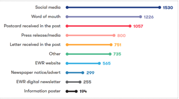
Figure 12-1: Numerical breakdown of responses to question 23
A total of 4,795 respondents answered this question. The feedback received informed us that the most common methods for finding out about the consultation were receiving information through the post via postcards and letters (33%), social media (32%) and word of mouth (26%).
We also provided respondents with the opportunity to tell us if they had found out about the consultation through any other method. Respondents that selected this option told us they heard about the consultation through a range of sources, including:
- Local councils, village and parish councils and community groups.
- Libraries, local events and community centres.
- Campaign groups such as BFARe and Cambridge Approaches.
- Schools, colleges, churches, and professional associations.
- Environmental groups, rail user groups and specialist forums.
- Consultation events, exhibitions, and meetings with our project teams.
- Media and digital platforms including YouTube, and Spotify adverts.
12.1 Consultation materials
The question we asked
We asked respondents to tell us how helpful they found our consultation materials. The feedback we received to this question is shown in Figure 12-2.
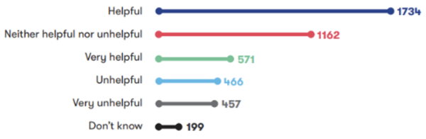
Figure 12-2: Numerical breakdown of responses to question 24
A total of 4,589 respondents answered this question, with 50% of respondents stating they found the materials ‘Helpful’ (38%) or ‘Very helpful’ (12%). 25% of respondents stated they found the material ‘Neither helpful nor unhelpful’, 20% found the materials either ‘Unhelpful’ (10%) or ‘Very unhelpful' (10%) and the remaining respondents stated that they didn’t know.
We also provided respondents with the opportunity to provide comments on this; these are summarised in the table below.
|
Sub-theme |
Feedback summary |
|
Accessibility of materials |
Some respondents found the virtual consultation room and online materials easy to access and appreciated the availability of 24/7 virtual resources and interactive maps. Many respondents reported difficulties in locating materials on the consultation website and suggested providing clearer links between consultation documents and forms. Some believed the online consultation excluded people who are digitally disengaged or visually impaired. This included concerns from a small number of respondents about residents without internet access being unable to view maps and plans online, alongside frustration about the lack of paper copies of consultation materials at events and libraries. They suggested better guidance on accessing specific documents, and more straightforward means of accessing information without reliance on virtual formats. Several respondents commented that consultation materials were often lengthy, technical, and difficult to understand, and contained technical terminology that impacted readability for non-technical audiences. Many respondents suggested improving the accessibility and usability of consultation materials included grouping all information related to a particular location together and providing plans in different formats. A small number of respondents also recommended publishing large-scale maps online and improving access to documents by making them more widely available at information points with longer opening hours. |
|
Information in materials |
Some respondents recognised the clarity, detail, and quality of the consultation materials, while a large number raised issues about inaccuracies, inconsistencies, and misleading information, such as errors in distances and the names of locations. Several respondents also felt that some information was not visible enough in the materials, making it difficult to assess the impact on significantly affected areas, including Cambridge and Bedford. A small number of respondents raised concerns about the reliability of traffic modelling, passenger projections, and freight service estimates, with concerns about outdated and optimistic data. The Transport Update Report was particularly criticised by a few respondents who felt that it contained inaccurate information and did not provide sufficient detail about the impact the project would have on traffic levels. Many respondents raised concerns about the lack of detailed information and transparency on the project’s scope and impacts particularly in reference to land access and safeguarding measures. One respondent believed that information had been added to the fact sheets during the consultation, disadvantaging earlier participants. Many respondents highlighted the need for accurate and up-to-date information, such as traffic and environmental modelling to reflect current and future conditions alongside detailed traffic management and construction access plans. They also called for clearer communication about the project's land requirement and overall implications. |
|
Maps and images |
Several respondents found materials such as large-scale maps, detailed route maps, and interactive maps useful. A large number of respondents felt that they were difficult to navigate and understand, citing unclear descriptions, outdated or incorrect information, and the absence of key details such as street names, landmarks, and contour lines. Several respondents highlighted that the maps did not present the precise impacts on local areas, properties, and infrastructure, making it difficult to assess the proposals. Specific issues included the lack of detailed maps for areas, such as the London Road level crossing and the Newton to Harston connectivity options. A small number of respondents highlighted confusion about the route passing beneath Comberton Road and extending onto land at Newmarket Road. |
|
Feedback form |
Several respondents highlighted difficulties in navigating the feedback form online, including some who felt the survey platform was not user-friendly. They cited a lack of features such as spell check, attachment upload options, and no option to save feedback forms. Some respondents also suggested that some questions were leading and not open-ended enough to allow comments on specific sections or broader issues such as route viability, environmental impact, farming and agriculture or compensation. The format was criticised by several respondents for being too long and confusing including a small number who felt that the feedback form had been designed to discourage participation. A few respondents suggested improvements including using separate feedback forms for different areas, linking questions to relevant sections of consultation documents. A small number of respondents also recommended including maps and illustrations in the feedback form to aid understanding, alongside offering downloadable and editable versions of the feedback form. |
|
Consultation website |
Many respondents shared mixed experiences with the consultation website. A small number found the website detailed, clear, and easy to access, which helped support more informed responses. Several respondents reported difficulties, including slow response times, error messages, and challenges with navigation. Specific issues included trouble locating key documents such as technical reports and route maps, alongside concerns about unclear or missing information. Suggestions for improvements to the consultation website included adding direct links to relevant documents on the home page and reorganising content to make it easier to find. There were also suggestions to create a dedicated section on the site for surrounding villages and towns, like Cambourne. A few respondents recommended ensuring all consultation materials are easily accessible and downloadable. |
12.2 Consultation process
|
Sub-theme |
Feedback summary |
|
General feedback |
Many respondents expressed that they were grateful for the opportunity to respond and thanked East West Rail (EWR) for the consultation. However, a very large number of respondents felt that the non-statutory consultation was a box-ticking exercise, with a sense that it came too late in the project timeline to allow for meaningful input. This included concerns from a few respondents that the process may have been deliberately delayed to limit opportunities for meaningful public input or influence over key decisions. A small number of respondents expressed frustration about pre-determined decisions and raised concerns that this would limit the consideration of community feedback in the design. They called for a more transparent and inclusive approach and raised suggestions to help build trust between EWR Co and local communities. Suggestions included commissioning an independent review of the decision-making process, reassessing all potential route options, and engaging more meaningfully with affected communities to ensure their concerns are properly addressed. It was also suggested the scope of the consultation was too narrow. Respondents felt it didn’t fully consider the overall impacts of related development projects and called for a more complete and timely consultation before key decisions are made. |
|
Promotion of the consultation |
A few respondents commended the promotion of the consultation, describing it as well published, whilst many other respondents felt that the promotional efforts were insufficient. Several respondents also expressed frustrations that they had not received consultation materials or notifications through post or email, nor seen any local signage. Further concerns were expressed by several respondents about the lack of direct communication, including some respondents who highlighted that they only learned about the consultation through social media. They felt that this excluded those without internet access or social media presence, particularly older generations and non-English speakers. Suggestions for improvements included better use of mail and emails, local newspapers, and clear signage. Respondents also emphasised the need to ensure all affected individuals are informed early in the process and given ample opportunity to take part. |
|
Consultation period |
Several respondents felt that the consultation period was too short, particularly as it overlapped with the Christmas and New Year holidays. This timing was seen as reducing the opportunity for people to engage fully and provide considered responses. It was also felt by a few respondents that some consultation events were held too close to the deadline, further limiting the ability to provide detailed feedback. A small number of respondents also raised that the length and complexity of some consultation materials added to the challenge, with many feeling the timeframe was insufficient. |
|
Previous consultations |
Many respondents commented on the 2019 and 2021 EWR non-statutory consultations, with a few asking for them to be re-run. They felt that these consultations lacked transparency and were poorly communicated, leaving many residents unaware or unable to participate meaningfully. In particular, several respondents criticised perceived misleading cost estimates and the omission of previously consulted route options, which they felt undermined the credibility of the process. Many respondents raised concerns about the selection of the route (consulted on in 2019) which had previously been presented as the most expensive and environmentally challenging. Many respondents stated that this route was later chosen without a clear explanation of how cost estimates had changed or why alternative routes were not reconsidered. Several felt the decision-making process appeared pre-determined, with consultation methods seen as biased and lacking genuine engagement with affected communities, including landowners and residents in areas such as Bedford, Cambridge, and South Cambridgeshire. While some respondents acknowledged improvements in the current consultation, such as more detail on proposals and mitigation measures, several others remained concerned about the project’s transparency and fairness and called for more open engagement moving forward. |
|
Development Consent Order process |
Many respondents expressed a range of views and concerns regarding the DCO process. Issues were highlighted by a few respondents regarding the use of permitted development rights within the railway boundary and the need for DCO powers. One respondent was unclear about how the DCO relates to Connection Stages 1 and 2 and whether the western improvements are amendments to previous proposals or new additions. Several respondents emphasised the importance of addressing the overall impacts of the project within the application for development consent including safeguarding directives and mitigation measures for affected communities and landowners. A few respondents also suggested more detailed environmental and economic impact assessments. It was further suggested by a few respondents that EWR Co demonstrate consideration of feedback as part of the DCO process. |
|
Engagement |
Several respondents raised concerns about communication relating to the consultation process, reporting issues such as unclear letters about land acquisition and inadequate responses to queries. A few respondents also felt that the consultation was not inclusive, with limited efforts to involve marginalised groups. There were suggestions from a few respondents for early and ongoing communication with affected communities, including schools, to ensure that local knowledge and concerns could be incorporated into the project design. This included requests for more targeted and transparent engagement, regular updates, and follow-up meetings. There were also calls from one respondent for regular updates on how feedback has been incorporated, including detailed responses to feedback and the publication of supporting data and analysis. A large number of respondents also requested further engagement to address unresolved issues such as access to severed land, the extent of land acquisition, and the purpose and duration of temporary land use. Many comments highlighted the need for timely and detailed information, closer engagement with statutory stakeholders and consideration of future growth and development needs. Suggestions included setting up a strategic board to support cross-boundary working, reaching early agreement on protective provisions, and providing community benefits such as investment in local facilities and schools. Collaboration with local authorities, developers, and Network Rail specifically on planning, design, and disruption management was also recommended by respondents. There was further emphasis on collaboration with local councillors and organisations to address ecological, archaeological, and landscape impacts, as well as integration with local development plans and other infrastructure projects. |
12.3 Consultation events
|
Sub-theme |
Feedback summary |
|
Online events and virtual consultation room |
A small number of respondents found the consultation room to be user-friendly and more engaging than traditional formats. Other respondents raised issues about the accessibility of online events, with a few respondents highlighting challenges for those without internet access or digital literacy. This was seen as a barrier for older people and residents of affected villages like Haslingfield and Harlton, where no face-to-face events were held. A small number of respondents were also frustrated by the lack of recorded sessions and limited interaction. They felt that muted microphones and disabled chat functions restricted two-way communication, and that questions raised during these events weren’t adequately addressed. A small number of respondents appreciated having the option to use an online virtual consultation room, finding it engaging and easy to navigate. A few other respondents felt that it was difficult to use and noted issues such as time-consuming navigation, lack of access to diagrams and cross-section drawings, alongside technical difficulties with some videos. |
|
In-person events |
Many respondents appreciated the opportunity to engage with technical specialists and noted positive interactions with knowledgeable staff at some events. Some respondents noted that events were informative and well-presented, with detailed consultation materials available to view. Several respondents raised concerns about the venues and timings of in-person consultation events. In particular, events held close to the Christmas period were seen as poorly timed, limiting attendance and engagement. A small number of respondents highlighted a lack of events in some affected areas, which they felt excluded key communities from the process. There were also concerns about the limited number of events overall, with a few respondents describing some locations as overcrowded and difficult to access for all attendees. Several respondents also raised concerns about the level of knowledge among project staff at consultation events. They reported that staff were unable to answer questions on key topics such as disruption, environmental impacts, funding, freight traffic, and the rationale behind the southern approach to Cambridge. Several respondents felt that the lack of detailed answers at the events indicated that certain decisions had already been made without fully considering public feedback. Several respondents raised suggestions for improvements, including better staff training to ensure teams are equipped to respond to a wide range of questions, and clearer communication of project details. Some respondents also suggested improvements to signage and advertising as well as recommending more accessible and appropriately sized venues. |
13. Get in touch
We’re here to answer any questions you may have. To find out more about East West Rail (EWR), head to our website at eastwestrail.co.uk. For specific questions about EWR or to raise any concerns, you can reach our team through the following channels:
- 0800 123 4567 (Monday to Friday, 9am to 5pm, excluding Bank Holidays)
- Freepost EAST WEST RAIL
- Follow us on Facebook
If you have a specific question about your land or property you can contact our dedicated Land and Property team:
- 0330 838 7583 (Monday to Friday 9am to 5:30pm, except Bank Holidays)
- Freepost EAST WEST RAIL LAND
If you want to speak to us about the Need to Sell (NTS) Property Scheme, you can email us at [email protected]
If you want to speak to us about Statutory Blight, you can email us at [email protected]