You Said, We Did Autumn Update
How feedback from NSC3 is helping inform design decisions, where we’ve been able to make key progress and outlining our next steps
November 2025
Table of contents
1. Introduction to East West Rail
2. Your feedback on our proposals
3. Work done since our consultation
Foreword
East West Rail (EWR) has the potential to bring real, sustainable growth to communities between Oxford, Milton Keynes, Bedford and Cambridge – bringing more jobs within reach of local people, opening up new journeys and reducing congestion on local roads with faster public transport options across the region. Your feedback is central to making sure this growth is delivered in the right way, connecting people with opportunities while protecting what matters most to local communities.
Our third non-statutory consultation, held between November 2024 and January 2025, received more than 6,000 responses from residents, landowners, local authorities, statutory bodies, businesses and many others along the route. I want to thank everyone who took the time to share their views – and it was a privilege for me to meet so many of you and hear your views directly at consultation events across the region. Your input is helping shape how EWR will be designed, ensuring it meets the needs of local people for years to come.
Since the consultation closed, our teams have been carefully analysing the feedback and refining our proposals. This You Said, We Did Autumn Update report sets out some of the progress we’ve made so far – including key decisions made since our consultation, as well as changes prompted by wider technical work and external developments, such as the proposed Universal resort near Bedford. We’ve accelerated progress on other key parts of our plans – such as a new station at Tempsford where EWR connects with the East Coast Main Line following government support, which is also covered in this document.
This is part of an ongoing process as plans are developed and refined – and we’re committed to keeping you updated throughout. Not every proposal is included in this report, as some are still being developed through further surveys, assessments and design work. We will share those updates with you as we continue our engagement and consultation process into 2026.
I also want to acknowledge that not everyone will agree with all of the proposals for EWR. In many cases, difficult decisions need to be made. We continue to work closely with communities and with land and property owners who may be directly affected, and I am determined that their feedback will play a vital role in shaping our decisions.
Thank you again for your involvement so far, taking the time to attend events and respond to the consultation. I look forward to meeting more of you along the route in the months ahead, and to continuing this important conversation as we design a railway that delivers benefits for generations to come.
David Hughes
Chief Executive Officer, East West Railway Company
1. Introduction to East West Rail
East West Rail (EWR) is a new rail connection being created to make travel between Oxford, Milton Keynes, Bedford and Cambridge simpler, quicker and more convenient. It’s about making everyday journeys easier – whether heading to work, for education, visiting friends and family, or exploring the region.
Currently, using public transport to get around the area can often mean going out of your way – sometimes even via London – just to reach neighbouring towns or cities. EWR will change that with direct and reliable services that bring communities closer together.
The region is home to world-class universities, growing industries, stunning countryside and vibrant communities. However, poor east-west transport links have made it harder for people to connect with the benefits the area has to offer. EWR will:
- Connect communities with better east-west rail links across the region.
- Encourage local investment, creating new job opportunities and opening up access to new homes.
- Improve journey times compared to travel by road and connect into north-south routes across the country.
- Offer a sustainable alternative to road travel that delivers value for money.
- Protect and support rail freight as an essential part of the UK’s supply chain.
To find out more about the project and how it could benefit your community, visit: eastwestrail.co.uk
2. Your feedback on our proposals
2.1 Consultation feedback
Between 14 November 2024 and 24 January 2025, we carried out our third non-statutory consultation offering local communities, landowners, and other stakeholders the opportunity to help shape our proposals. The consultation shared emerging plans and gathered feedback on our design proposals and options.
We provided an overview of how the consultation was delivered and some emerging findings in our 2024 Non-Statutory Consultation Update published in May 2025, which can be found by visiting: eastwestrail.co.uk/consultation2024.
As part of the consultation, we asked for feedback to help us develop plans for:
- The railway’s alignment.
- Station locations and sizes, parking, and access.
- How the railway would cross roads and rivers.
- How the railway would impact existing level crossings.
- Ways to avoid or reduce environmental effects and improve both the natural and built environment.
We also asked for feedback about our approach to consultation and the information we presented, to help us improve any future consultations we carry out.
In total, we received 6,218 responses which included feedback on route-wide matters as well as specific proposals in local areas.
Following the consultation, we carefully analysed the feedback received and grouped feedback comments into themes, including:
- Community benefits and impact.
- Environment and sustainability.
- Traffic and transport.
- Construction and logistics.
- Land and property.
Comments related to specific locations or design features were also grouped, including:
- London Road level crossing in Bicester.
- Marston Vale Line (MVL) options.
- Bedford and Bedford St Johns stations.
- Tempsford alignment and station.
- Cambourne station.
- Bourn Airfield tunnel.
- Connectivity between Newton and Harston.
- Cambridge and Cambridge South stations.
The feedback we received, combined with previous consultation feedback from before 2024 and alongside ongoing surveys and assessments, has helped us to refine our proposals and inform design decisions about some elements of the project. These decisions are set out in Chapter 4 with an explanation of how your feedback has helped to shape our updated proposals.
Some feedback to the most recent consultation expressed concerns about the proposed route of East West Rail, with respondents expressing their preference for alternative route options. We recognise these concerns, but the purpose of the most recent consultation was not to obtain feedback on alternative route options that have been the subject of the previous consultations.
We’ve explained the reasons for our route alignment choices in previous project updates, following non-statutory consultations in 2019 and 2021 – more information can be found in our previous consultation feedback documents, which can be found by visiting: eastwestrail.co.uk/previous-consultations.
A thematic summary of all of the consultation feedback is presented in the 2024 Consultation Feedback Summary Report, which can be found by visiting: eastwestrail.co.uk/you-said-we-did.
3. Work done since our consultation
3.1 Stakeholder engagement
Since our most recent consultation closed, we’ve continued to engage with local communities, local authorities, environmental bodies, affected landowners, utilities companies and emergency services. As part of this, we’ve been working with stakeholders to review design elements in detail, such as highway designs, environmental assessments, flood risk assessments and construction planning.
Our specialist Land and Property team is working closely with affected land and property owners to explain the proposals and how they could be impacted, understand their individual circumstances, answer questions and discuss what support may be available to them. You can read more about this in Chapter 3.3.
We’ve continued to engage with stakeholder groups that we’ve set up to support ongoing engagement with communities along the proposed East West Rail (EWR) route. These include our Local Representative Groups and the Accessibility Advisory Panel. These groups bring together local elected representatives, including ward and parish councillors and those with disability or accessibility challenges for open discussions with project team representatives throughout all stages of the project. To find out more about these groups visit: eastwestrail.co.uk/communityhub and eastwestrail.co.uk/accessibility-and-inclusion.
We’ve also engaged with Members of Parliament, working with them on issues that are important to their constituents. Feedback from this continuing engagement is assessed and reviewed as part of our ongoing design development process. These channels and forums support collaborative working by keeping communities and decision-makers connected and involved throughout the development of EWR, helping to shape a project that reflects local experiences and priorities.
3.2 Environment and sustainability
During each stage of the planning and development process, environment is a key consideration in every decision that we make. We want to contribute positively to the environment, including delivering Biodiversity Net Gain.
At our most recent consultation we provided an update on our Environmental Sustainability Strategy setting out the six environmental pillars and the strategic objectives which are shaping our ongoing design development. We also published our Environmental Update Report, which provided information about environmental considerations, anticipated impacts, our approach to environmental assessment and mitigation strategies for our proposals.
Since our most recent consultation ended, we’ve continued to carry out a range of surveys and studies across the route. This information is being used to better understand the impacts our proposals may have and how we can avoid or mitigate these.
We’ve taken a number of steps, including:
- Carrying out more detailed work that would protect surrounding communities and the railway from flood risks, which is particularly important in a changing climate.
- Refining our environmental mitigation proposals to reduce the scale and extent of environmental impacts associated with the construction or operation of the project.
- Managing the visual impacts of the railway, including lowering the height of embankments and viaducts in some locations alongside plans for landscaping, planting and reducing the size of earthworks between Bedford and Cambridge.
- Speaking with landowners and agricultural businesses to help manage our impact on their operations and shape proposals for habitats and other environmental features on their land.
- Carrying out detailed ecological surveys to understand the locations where the project might affect sensitive habitats and species along the route and what mitigation strategies might be required to protect these.
- Collaborating with other major projects, such as the new A421 dual carriageway currently being constructed by National Highways as part of the A428 scheme so that we can share survey data and coordinate our mitigation proposals.
- Carrying out investigations to identify areas that may contain valuable archaeological features and to help to find out important information about the soil, rock and groundwater below the surface to help us to design a railway in a responsible and environmentally sustainable way.
- Setting up a Biodiversity Net Gain Forum to bring together interested parties, contributing knowledge and expertise to help us develop plans to deliver an overall improvement in biodiversity (i.e. plants and wildlife).
- Establishing a Water Forum to engage with stakeholders on how to avoid or mitigate impacts to rivers, watercourses, ponds and lakes that are crossed by the project and best inform our approach to managing flood risk.
In January 2025, we submitted an Environmental Impact Assessment (EIA) Scoping Report to the Planning Inspectorate. This marked a key milestone in the project’s development, initiating a formal consultation, led by the Planning Inspectorate, on the proposed scope and methodology for the EIA. The consultation sought comments from a range of statutory bodies, whose feedback was appended to the Scoping Opinion, which was adopted by the Planning Inspectorate (on behalf of the Secretary of State) on 12 February 2025.
The Scoping Opinion sets the parameters that EWR should follow when assessing the environmental effects of the project. These agreed principles will now form the basis of the EIA and will be reflected in the Environmental Statement that accompanies our application for development consent.
3.3 Land and property
We understand that our proposals will have an impact on land and property owners, including local residents and businesses, where there is a possibility of land or property being required by EWR. We want to work closely with those potentially affected, take the time to understand their circumstances, and provide clear information and support throughout the project.
We’ve allocated case managers to land and property owners to ensure those affected by our plans know who to reach out to with their concerns and questions. Each case manager is building relationships with them as part of an ongoing engagement programme.
We’re also keeping our land ownership records updated using HM Land Registry data, land interest questionnaires, landowner meetings and site visits. This is an essential part of the project development process for projects like EWR, as this helps to identify who owns, occupies and uses land that may be affected by the railway – and it means we can keep people fully informed about our proposals and the planning process.
The Secretary of State for Transport is updating the Safeguarding Directions for EWR and the safeguarded area is being updated where design work has advanced to confirm changes to the project boundary. The Safeguarding Directions mean that local planning authorities must consult us about relevant planning applications for development within the safeguarded area that could conflict with the railway. This allows us to comment on particular conflicts and suggest measures that could be taken to resolve them and, where possible, allow development to go ahead.
As well as helping to protect the land needed for our proposals, the Safeguarding Directions also mean that statutory blight provisions are available. If you own and occupy a property in the safeguarded area, you may be eligible to serve a blight notice on us asking us to buy your property before we need it to build the railway.
Our Need to Sell Property Scheme and Statutory Blight provisions are available for eligible land and property owners who wish to sell their property to us before we need it for EWR. More information about land and property at EWR can be found by visiting: eastwestrail.co.uk/landand-property.
3.4 Traffic and transport
Since our most recent consultation, we’ve reviewed feedback and used it to improve how we assess the potential impact of EWR on the transport network and where we might need to make changes.
We’ve been developing a detailed highway model that simulates the highway network along the full route of the railway. We’ve also liaised with Local Highway Authorities (LHAs) across the route to make sure they are happy with this model. This has involved looking at other developments –like new transport projects, housing, or job sites – that could affect traffic, in addition to the impact of the new EWR train services.
We’ve also been working with National Highways to make sure the railway doesn’t prevent future improvements to the strategic road network not associated with EWR. The model looks at both the construction and operation phases and helps us spot where congestion or delays may happen in the future. We’ve also carried out traffic and walking/cycling surveys to help build a solid base for the model.
We’ve updated our approach to the Transport Assessment based on feedback received on the EIA Scoping Report. This includes improving how we use the model to find places that may need road improvements. We’ve started testing this and are beginning to plan possible solutions to discuss with LHAs.
We’re also looking at how to improve walking and cycling routes to help people reach EWR services, including filling in any ‘missing links’. We’re reviewing public rights of way affected by the project to find suitable alternative routes and keep people connected.
Our traffic and transport assessment work has been contributing to the design development of the project itself, for example by testing how people move around station entrances and how traffic flows at nearby junctions.
We’re continuing to work with LHAs as we finalise the model and use it to find where mitigation may be needed to reduce any negative impacts from the EWR project.
4. Updates on our proposals
4.1 Overview
The following chapters explain the decisions we have taken on our proposals following the most recent consultation. They also provide information about the ongoing design work we are carrying out, including in some areas where further work is needed before we can confirm our proposals.
We’ve provided updates for route-wide matters as well as our proposals in the following eight route sections:
- Oxford to Bletchley
- Fenny Stratford to Kempston (Marston Vale Line)
- Clapham Green to Colesden
- Roxton to east of St Neots
- Croxton to Toft
- Comberton to Shelford
- Cambridge
Table 1 summarises the updates we are providing on our proposals and shows where more information can be found about them.
Each of the following chapters explains how feedback from the most recent consultation, together with further technical and environmental work, has informed our design decisions. A full overview of the feedback we received is presented in the 2024 Consultation Feedback Summary Report which can be found by visiting: eastwestrail.co.uk/you-said-we-did. You can also view our interactive map via this webpage which shows the maps and figures presented within this report.
There are some areas of the project where further work needs to be carried out before decisions can be taken. This report provides an update on some of those areas of design development and explains the ongoing work and assessments that are being carried out. We’ll present our updated proposals as part of further consultation that will be carried out next year before we finalise our application for development consent. Chapter 5 provides more information about this.
We shared plans of our project at our most recent consultation and these can be seen on our website by visiting: eastwestrail.co.uk/consultation2024. As we finalise proposals, we will be updating these plans and will publish these when we consult in 2026.
Table 1: Overview of project updates presented within this report
|
Proposal |
Update |
See further information in chapter |
|
Expanding our capacity |
In response to new proposals for development along the line, we have concluded that we need to provide additional capacity at our stations and on our services to deliver the connectivity and growth for communities and businesses along the corridor. |
4.2 |
|
Overhead line electrification |
We’ve decided to use a discontinuous electrification system between Oxford and Cambridge. We’re continuing to work on this area of the design to confirm the locations of where electrification equipment would be installed. |
4.4.2 |
|
Oxford area improvements |
We’ve updated our design based on the assumption that the Cowley Plus scheme (a Network Rail project that proposes to reopen the Cowley Branch Line to passenger traffic) will be delivered ahead of East West Rail (EWR). |
4.5.1 |
|
London Road level crossing, Bicester |
We’ve reviewed options to maintain access at London Road level crossing and have developed a further proposal for an underpass with a single-lane, height-restricted vehicle route, plus protected access for pedestrians and cyclists. The delivery of this option would be subject to securing third-party funding contributions. We have also developed the footbridge proposal to include lifts (as well as stairs) instead of ramps, to reduce the visual impact of the structure. This option is not expected to require third party funding contributions. We’ll continue to engage with the local stakeholders on these two designs, and will present a final proposal for engagement and consultation in 2026. |
4.5.2 |
|
Bletchley station |
We’re considering and have included an eastern entrance at Bletchley station within our proposals. The delivery of this additional entrance would be subject to third-party funding. |
4.5.3 |
|
Marston Vale Line (MVL) stations and train services |
We’re confirming the Consolidated Stations Option (Concept 2) as our preferred option for the MVL. This option will see the nine existing stations closed and replaced with four new stations at Woburn Sands, Ridgmont, Lidlington and Stewartby, along with the relocated Bedford St Johns station. |
4.6.1 |
|
Ridgmont station |
We’ve selected Option 1 as the proposed location of Ridgmont station to help support new areas identified for housing and development. This will relocate the station to the west of Bedford Road and locate station facilities and car parking north of the railway. |
4.6.2 |
|
Stewartby station |
We’ve selected Option 2 as the proposed location for a consolidated Stewartby-Kempston Hardwick station. However, we are still working to confirm the design and exact location for this station to maintain accessibility to both existing users like Kimberley Sixth Form College and Stewartby village, whilst also supporting connectivity to the Universal proposals. |
4.6.3 |
|
Bow Brickhill level crossing |
In light of changes to our train services, we’re carrying out further assessments to decide whether the crossing could be retained. If the crossing does need to close, we would provide a bridge to avoid wider traffic impacts. |
4.6.4 |
|
Bedford St Johns station |
We’ve worked with key stakeholders such as Bedford Hospital and Bedford Borough Council to refine our proposals for the station layout and car parking. |
4.7.1 |
|
Bedford station |
We’ve updated our design proposals to add station improvements including a dedicated public open space and a western entrance, a relocated multi-storey car park, as well as introducing a new platform to help the railway operate reliably in the future. |
4.7.2 |
|
Tempsford alignment and station |
We’re confirming Option 1c as the preferred alignment for Tempsford, to support future development and the opportunity for new homes. Our design will put the station at the centre of the future development site. |
4.9.1 |
|
Acceleration of Tempsford station |
In January 2025, the government announced its intention to deliver the East Coast Main Line part of the station ahead of the full delivery of the EWR station. This would bring some of the benefits of the EWR project to the Tempsford area sooner and we’re working with Network Rail to accelerate the design and delivery of the East Coast Main Line part of the station. |
4.9.2 |
|
East Coast Main Line rail logistics hub |
We’ve selected Option B as the preferred location for the rail logistics hub on the East Coast Main Line. This site would be located on land between the new EWR route and the new A421 dual carriageway. |
4.9.3 |
|
Cambourne station |
We’ve decided to relocate the proposed station at Cambourne 700 metres west of the site we’d previously proposed. We believe this new location would be better placed to facilitate new housing and aligns more closely with the South Cambridgeshire Local Plan and reflects stakeholder preferences. |
4.10.1 |
|
A428 Bourn Airfield crossing |
Following the review of feedback on our construction approach, we’ve decided to switch the form of construction for this crossing from a cut and cover tunnel to a mined tunnel. As well as being cost efficient, it reduces disruption to existing road users and has lower development and environmental impacts. |
4.10.2 |
|
Newton to Harston connectivity and Newton footbridge |
We’ve selected Option 4 as the preferred option for maintaining connectivity between Harston and Newton. This will provide a road connection via London Road. A new road connection north of an overbridge would use the route of the former Shepreth Branch Royston Line track to connect to Station Road, south of Harston. In addition, we propose to construct a new footbridge near the location of the existing level crossing. |
4.11.1 |
|
Cambridge station |
We’ve decided to include an eastern entrance to the existing Cambridge station to better connect the station on either side, and support new homes and businesses planned in the area. |
4.12.1 |
|
Cambridge East station |
We’re considering including a new Cambridge East station within our proposals for EWR to support new homes planned for the area. The delivery of this new station would be subject to third-party funding. |
4.12.2 |
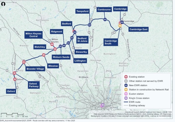
Figure 1: Map of the East West Rail route
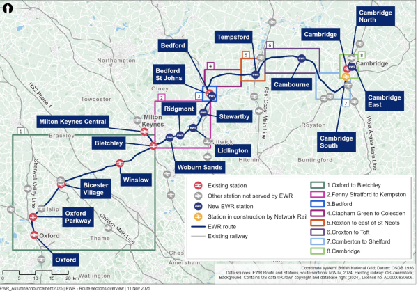
Figure 2: Map of the East West Rail route sections
4.2 Expanding our capacity
Proposals for significant development across the Oxford-Cambridge Growth Corridor have come forward since our most recent consultation, partly in response to the government’s support for EWR.
These include Universal’s proposals for a resort near Stewartby south of Bedford, which represents a significant local and national opportunity for economic growth. A range of other development proposals are also seeking to take advantage of the benefits of EWR and invest in the region. We are working with many of these stakeholders to help them integrate their proposals with the railway and maximise the potential of both.
As a result of these new developments, demand for EWR might be significantly higher than previously predicted. We have carried out further analysis to understand how our proposals might need to adapt to accommodate this additional demand.
This work has concluded that we need to provide additional capacity at our stations and on our services, particularly at peak times. This means making some significant changes to the project which are needed to achieve the primary purpose of the railway – to deliver connectivity for communities along the corridor.
We are still working through the detail, but the changes we’re proposing, implemented in the right way, will benefit everyone:
- We’re planning to deliver more passenger rail services, up to a maximum of five trains per hour during peak times, alongside freight trains. This supports the approach for Consolidated Stations along the MVL which would provide modern high capacity stations at Woburn Sands, Ridgmont, Lidlington and Stewartby.
- We’re also exploring options to lengthen our passenger trains to increase the number of seats on each service, which could mean increasing from four to five carriages.
- We’re continuing to explore what this means for our infrastructure proposals, particularly in terms of our depots, stabling and level crossings as longer, more frequent trains will increase the demands on these elements.
- We’re now planning to provide a consolidated Stewartby-Kempston Hardwick station which would allow people to travel to the Universal resort without negatively impacting other users. See Chapter 4.6.3 for more details about Stewartby station and the Universal resort.
- We’re assessing whether additional capacity and features at key interchange stations are needed, including Oxford, Bletchley, Milton Keynes, Bedford, Tempsford and Cambridge, to prevent overcrowding at peak times.
- We’re exploring opportunities to extend services from the wider rail network onto EWR to minimise the need for additional EWR trains, depots and stabling, as well as to deliver additional connectivity across the UK.
We’ll share more details on our updated infrastructure proposals as we engage with stakeholders and communities over the coming months and when we consult in 2026.
4.3 Delivering services earlier
We are working to deliver services across the region at the earliest opportunity and that includes utilising the government’s proposed planning reforms to streamline the planning process. The Department for Transport will confirm a start date for services between Oxford and Milton Keynes as soon as possible, once station construction activities, operational planning, train testing and driver training are all completed. We have also committed to bring forward delivery of a new station at Tempsford to introduce services on the East Coast Main Line to the area ahead of the full EWR scheme opening.
We are also assessing the best way to sequence the programme as a whole as our plans are refined. Following announcements about new investment in the region, we are reviewing whether the previously proposed additional train to Bedford from the west, which would start ahead of full route completion, would manage expected demand.
As a result, we are looking at whether there are alternatives to bring higher frequency passenger services and new stations to this section of the line earlier, to unlock benefits for local people and businesses. We will be working on this over the coming months and will provide a more detailed plan as we continue to consult and engage on updates into next year.
4.4 Route-wide matters
We've listened to your feedback on route-wide matters, including:
- Door-to-door connectivity.
- Overhead line electrification.
- Flood risk management.
- Off-route highway works.
We're continuing to work on these parts of our design and provide an update below. We will provide more details when we consult in 2026.
4.4.1 Door-to-door connectivity
We remain committed to supporting door-to-door connectivity, helping people travel from their starting point to their final destination, not just from station to station. This means not only improving rail services but also promoting active travel options, such as walking, wheeling (using a wheelchair or mobility aid) and cycling; as well as ensuring there are appropriate facilities at stations for access by car and bus. By doing so, we can make stations more accessible, support carbon reduction goals, and help people stay connected with their communities.
During the last consultation we received a very large number of responses relating to door-to-door connectivity, highlighting the importance of walking and cycling access to stations and improved connectivity for communities. These responses included location-specific suggestions, which we’ve reviewed and, where possible, started to include in our designs.
To date we’ve identified many changes that could be implemented to strengthen existing provisions and support a more connected door-to-door network to support travel to and from stations. We’re working closely with local authorities, sub-national transport bodies and developers to explore how these improvements could be delivered to enhance connectivity and encourage more active travel in the region.
Examples of changes include new active travel routes along the railway to connect existing and new stations along the MVL, new crossings over the railway to maintain public rights of way between Bedford and Cambridge, as well as additional connections in the Harston and Hauxton area to connect to the wider network in Cambridge. The EWR proposals have been designed to integrate with both the existing network and planned active travel corridors in each local authority area, supporting more sustainable transport choices. We're continuing to work on these parts of our design and more details will be provided when we consult in 2026.
Good station connectivity goes beyond active travel. We’re developing designs for bus access, parking, and facilities to support pick-up and drop-off by private car and taxi. Our plans also look at how car parks can enable electric vehicle charging. As we finalise the parking strategy, we’ll balance providing enough capacity for future demand with protecting surrounding communities from adverse impacts.
4.4.2 Overhead line electrification
We previously confirmed that we propose using an overhead line electrification system to power EWR trains, which would involve a network of wires above the tracks (known as overhead line equipment). We also explained that overhead line electrification to power our trains could be done by either discontinuous electrification or full electrification.
Discontinuous electrification means overhead lines would only be installed along some sections of the route, and the trains would be powered by onboard batteries on the sections without overhead lines. Full electrification would involve overhead lines being installed along all sections of the route. We stated that our preference was to use discontinuous electrification.
Feedback from the consultation included both support for and concerns about our proposals. Several respondents supported discontinuous electrification of the line in the context of net zero aspirations and recognised that this shows a commitment to sustainability. However, a few respondents expressed concerns about the reliability of discontinuous electrification, which they suggested is still a fairly new technology. Different approaches for powering the trains such as green energy alternatives and hydrogen power were suggested by respondents.
Taking account of the consultation feedback, we’ve decided to use a discontinuous electrification system between Oxford and Cambridge. The reasons for this include:
- It would still allow us to move away from the use of diesel passenger trains once the infrastructure is built. This means our ambition of becoming a zero-emissions passenger railway would not be compromised through this approach.
- It would minimise the overall cost of the project as less infrastructure would be required, whilst enabling EWR to provide faster and greener services and net zero journeys with battery-electric trains.
- Battery-electric trains are a proven technology with many options available from train manufacturers, which reduces cost compared to other types of low carbon technology.
- There would be fewer permanent impacts to the landscape and environment compared to full electrification, particularly in more sensitive locations on the new railway between Bedford and Cambridge. This is due to the reduction in overhead line infrastructure required along the route by approximately 50%. We also wouldn't need to construct as many compounds along the EWR tracks to feed power to the overhead wires. Both of these factors would significantly reduce the structural and visual impact of the railway on nearby communities.
- In the non-electrified sections, we would not need to divert or raise any of the existing overhead utilities cables which currently cross the railway. It also means we could avoid impacts on existing road bridges.
- There would be fewer construction impacts associated with constructing the EWR line. The reduced infrastructure required for the discontinuous electrification approach means we could reduce the volume of HGV traffic on local roads, which in turn would lessen other impacts such as construction noise and vibration.
- We may be able to avoid running electrification past sensitive receptors along the route, such as hospitals and universities. Overhead line electrification can generate electromagnetic fields, which have the potential to disrupt sensitive equipment such as MRI machines in hospitals, or electron microscopes in labs if not mitigated properly. Through adopting a discontinuous electrification approach, we can reduce this risk significantly.
- The trains would be more reliable, as battery power would be used if there was a fault with the overhead line.
- This approach would be in line with the emerging approach being taken by the rail industry across the network where electrification does not presently exist.
We’re continuing to work on this area of the design to confirm the locations of where electrification equipment would be installed and more details will be provided when we consult in 2026.
4.4.3 Depots
At our most recent consultation, we explained that to ensure the smooth and reliable running of EWR services for passengers, we would need places to stable and maintain trains when they are not in service. This includes a main Train Maintenance Depot (TMD), and several smaller Light Maintenance Depots and sidings. In addition, an Infrastructure Maintenance Depot and satellite sites would be required to support the maintenance of the railway itself. These will house the people, materials and equipment needed to keep the network running safely and efficiently. We also shared a series of search areas that were being reviewed to identify suitable locations for these facilities.
In response to the consultation, a small number of respondents expressed concern about the potential impacts of depot locations on nearby communities, including noise, disruption, and loss of farmland. The potential effects on wildlife and sensitive ecological areas were also raised. Respondents suggested that depots should be located away from residential areas and that existing sites, such as at Bletchley or Northampton, could be reused or expanded rather than developing new facilities on greenfield land. A small number of respondents also questioned the inclusion of depot land within the safeguarding boundary, suggesting that focus should be placed on areas closer to existing stations or industrial land.
Since then, we have worked closely with our technical specialists to assess the operational, environmental and engineering considerations for each of the potential sites. This detailed work has helped us refine the shortlist and move closer to identifying our preferred location for the TMD.
We recognise the importance of this decision, both for the operation of the railway and for the communities around it. For that reason, we have been carefully reviewing each site against key criteria, including connectivity to the existing railway, sustainability, deliverability, and the potential to minimise impacts on residents, local businesses and the environment.
We are now nearing the conclusion of this process and expect to confirm the proposed location for the TMD in the near future. Once a decision has been made, we will provide further information and hold open discussions with local authorities, landowners and affected businesses to explain our reasoning, listen to feedback and work together to reduce any potential impacts.
Work is also continuing to identify the best locations for the Light Maintenance Depots, the Infrastructure Maintenance Depot, and sidings along the route. Together, these facilities will help ensure the railway operates reliably, supports local employment and investment, and delivers long-term benefits for the region.
4.4.4 Flood risk management
It is vital that the railway is designed to be resilient to flooding and does not increase flood risk elsewhere. Flood risk considers flooding from main rivers and watercourses, surface water, groundwater, reservoirs and other sources.
We’re currently carrying out modelling to assess the expected influence of the project on flood risk to people, property and other infrastructure and to test the project’s resilience to future climate conditions.
We’re also refining the design to reduce the extent of encroachment into areas liable to flooding where possible. At locations where this is unavoidable, we’re identifying areas where flood water can be stored temporarily to compensate for the loss of existing floodplain as a result of the railway. In more heavily built-up areas, we’re also identifying locations where water may need to be stored in underground tanks to manage the amount of water entering watercourses and drains during storm events. These will be sized to include an allowance for climate change.
More details will be provided when we consult in 2026.
4.4.5 Off-route highways work
We’re currently carrying out traffic and transport assessments across the project to evaluate whether existing roads are suitable and have sufficient capacity for construction traffic and future passengers travelling to and from stations.
Some roads would experience increased traffic, either temporarily during construction or more regularly once the railway is operational. We want to reduce disruption for local communities and road users and we're looking at ways we could do this.
These mitigation measures fall into two categories:
- Localised highway improvements – such as modifying junctions to increase capacity or reduce disruption.
- Exploring alternative construction routes.
As we do more work on these measures, we’ll continue to engage with Local Highway Authorities, and National Highways on our final proposals.
4.5 Oxford to Bletchley
This section of EWR runs between Oxford and Bletchley and is approximately 48 kilometres (30 miles) long. Proposals in this area would build on the improvements already happening between Bicester and Bletchley, supporting the planned increase in EWR services.
Within this chapter we provide updates on the following proposals:
- Oxford area improvements
- London Road level crossing, Bicester
- Bletchley station
We also provide design development updates on the following topics:
- Passing loops
- Oxford Parkway
- Environmental mitigation
An overview of the updates is shown in Figure 3.
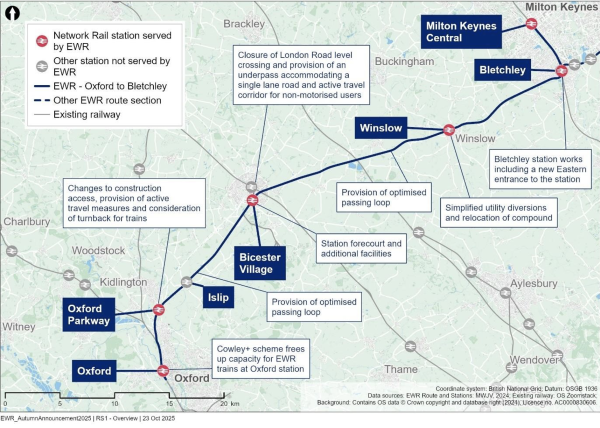
Figure 3: Map illustrating Oxford to Bletchley route section
Proposal updates in this route section
4.5.1 Oxford area improvements
What we presented at our 2024 non-statutory consultation
We explained that we were working closely with Network Rail to integrate our proposals with work being carried out to improve rail services in the Oxford area, notably the work currently underway at Oxford station.
We also explained that we’re considering how trains could continue beyond Oxford to relieve pressure on Oxford station by trains not occupying platforms for extended periods of time. This involved exploring the potential for other projects, such as the proposed reopening of the Cowley Branch Line being promoted by Oxford City Council, to support a solution to the capacity constraints that exist around Oxford.
What you told us
A small number of respondents recognised that the reopening of the Cowley Branch Line and its integration with EWR could improve connectivity and reduce pressure on Oxford station.
Several respondents also suggested extending EWR services to call or terminate at Didcot to allow direct interchange with the Great Western Main Line. They highlighted how this could improve connectivity in South Oxfordshire and reduce rail congestion at Oxford station.
How we’ve updated design proposals
Following wider support for the Cowley Plus scheme from the local community, Network Rail and the government, we’re currently working on our designs on the basis that the Cowley Branch Line will be reopened, as proposed by Oxford City Council. This would mean that platform capacity will be freed up at Oxford station, allowing the full EWR service to run to Oxford station. More details will be provided when we consult in 2026.
4.5.2 London Road level crossing, Bicester
What we presented at our 2024 non-statutory consultation
At London Road level crossing in Bicester, we proposed closing the level crossing. Based on the assessment of four EWR trains running per hour in each direction, in addition to existing train services, the barriers at London Road level crossing would be down for at least 32 minutes every hour. This would lead to:
- Significant waiting times.
- Increased congestion, with queuing expected to back up to Market Square and the A41/A4421 roundabout.
- The potential for misuse of the crossing, due to the increased waiting times, raising safety concerns and increased risk of injuries and fatalities.
We presented two options to provide an accessible replacement crossing for pedestrians, cyclists and other non-motorised users (NMUs), to make sure people can still access Bicester safely and easily. These options were:
- Option 1a – provide a footbridge with ramps and stairs.
- Option 1b – provide an underpass.
For both options road traffic would be rerouted via existing roads, with local road improvements to reduce journey times.
What you told us
We asked respondents to share their preference between Option 1a and Option 1b, as well as giving the choice to respond with ‘No preference’ or ‘Other’. We also provided respondents with the opportunity to provide comments about this proposal. The feedback we received is summarised below.
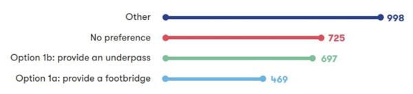
Figure 4: Numerical breakdown of responses to question 5a
A total of 2,889 respondents shared their preference for maintaining access for pedestrians, cyclists and other NMUs at the London Road level crossing in Bicester. More respondents expressed a preference for Option 1b, an underpass (24%) than Option 1a, a footbridge (16%). The largest proportion of respondents to this question (35%) selected ‘Other’. A further 25% selected 'No preference'.
Respondents shared a wide range of views on the proposed closure of the London Road level crossing in Bicester, highlighting the importance of maintaining connectivity for all users. Measures to mitigate antisocial behaviour on a potential footbridge or underpass and a new pedestrian crossing on Launton Road were also suggested by respondents.
Respondents emphasised the need to prioritise pedestrian and cyclist access, and supported the inclusion of infrastructure that is safe, accessible, and well-integrated with the town’s wider travel network.
Option 1b (provide an underpass) was the more popular of the two options, with many respondents noting its potential to offer a more accessible and direct route for pedestrians and cyclists, particularly those using wheelchairs or pushchairs. However, several respondents raised concerns about flooding, antisocial behaviour and safety, and night-time safety, and a few respondents raised issues about the long-term maintenance of the underpass.
Option 1a (provide a footbridge) was seen by several respondents as a quicker and potentially less disruptive solution during construction, though a large number of respondents raised issues around accessibility. A few respondents commented on safety in poor weather, and many raised visual impact as an issue.
Many respondents felt that neither option fully met the town’s needs, especially the need for access by cars and other vehicles. Suggestions included keeping the level crossing open with improved signalling, building an underpass or bridge for vehicles, or exploring alternative crossing points such as at Gavray Drive. There was interest in integrated proposals that support access for drivers, pedestrians, and cyclists.
Respondents also highlighted the importance of maintaining access for residents of Langford Village, Graven Hill, and surrounding areas, and ensuring that any solution supports access to the town centre, particularly for vulnerable groups and those reliant on public transport. Many respondents also raised concerns about the potential impacts of the crossing closure on both emergency services and local businesses.
Many respondents raised concerns about the environmental impact of the proposed closure of the level crossing in Bicester. It was highlighted that the crossing's closure may lead to increased congestion, longer journey times, and higher emissions due to traffic being rerouted onto already busy alternative routes.
How we’ve updated our design proposals
We have carefully considered the feedback to the consultation and carried out further technical work on the options. This included considering the potential to improve the design of the footbridge presented at the consultation by including lifts (as well as stairs) in place of ramps. As part of this work, we considered the impact of the proposed closure of the level crossing on people with characteristics that are protected under equalities legislation and how these impacts might be mitigated.
We’ve also identified a further option for a revised underpass design which includes a single-lane road that could be used by vehicles, alongside a protected active travel corridor for pedestrians and cyclists. Traffic signals would be installed at each entrance to allow vehicles to travel through the underpass safely in both directions. The underpass could not be used by over-height vehicles such as lorries. Delivering an underpass proposal would be subject to securing third-party funding contributions
The revised underpass design responds to feedback from the consultation and further engagement with local stakeholders, which highlighted the potential for significant future development to the east of Bicester, accessibility concerns and feedback about the visual impact of a footbridge.
As well as the above, we’ve further developed the design to provide the following benefits, compared to the Option 1b proposals shown at our most recent consultation:
- A more direct underpass alignment which provides a quicker route towards Market Square to the north, providing both community and environmental benefits, including more accessibility options for crossing the railway and reduction of carbon emissions associated with vehicle exhaust fumes.
- Enhanced pick-up and drop-off facilities to the south of Bicester Village station.
As we develop the underpass design further, there will be a need to introduce highways restrictions to reduce the risk of oversized vehicles attempting to use it. We’re engaging with relevant stakeholders, including local authorities, to develop these measures in our designs, should we progress with this option. Further analysis is also ongoing to assess how this option may impact the wider traffic network around Bicester. This will determine if junction upgrades may be required in other areas to alleviate congestion.
The new underpass option would require the acquisition of a number of properties along London Road. In developing the underpass design, we considered the impacts on landowners and concluded that the need to acquire additional land is justified by the benefits it would provide to all road users. We’ve already informed those people whose properties are affected, and we’re continuing to assess how much land is needed. As the design evolves, we’re actively aiming to reduce the number of properties impacted. Chapter 3.3 provides more detail on land and property matters including support available for affected owners.
We’ll continue to engage with local stakeholders on the further option for a single-lane, traffic signal-controlled underpass as well as the option for a footbridge with lifts and stairs, prior to consulting on a final proposal in 2026.
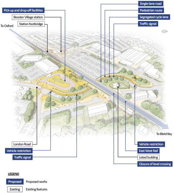
Figure 5: Aerial illustration of proposed single lane underpass
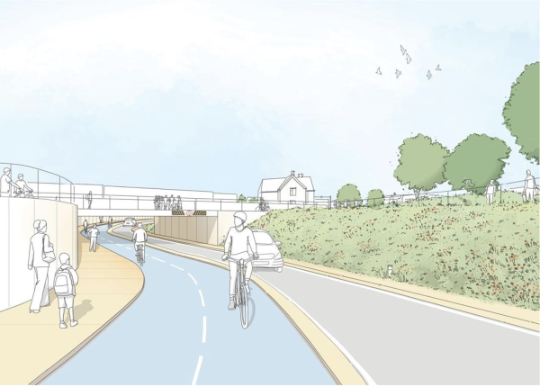
Figure 6: Illustration of proposed single lane underpass
4.5.3 Bletchley station
What we presented at our 2024 non-statutory consultation
Bletchley station would become a key interchange for passengers to connect between EWR and the West Coast Main Line, as well as integrating with local services between Bletchley and Milton Keynes.
In our most recent consultation, we explained that we‘re working with local authorities and stakeholders to improve the station’s connectivity with the surrounding community, enhance the public realm and promote sustainable growth by offering new connectivity and active travel options.
We outlined that since the Route Update Announcement in 2023 we’d reviewed potential improvements to Bletchley station including improvements to the west ticket hall, platforms and footbridges. We also stated that as part of our work with Milton Keynes City Council, we were testing the strategic and economic case for a new eastern entrance to the station at Bletchley.
What you told us
Several respondents told us how important it is to integrate the station with the surrounding streets and to provide active travel options, such as safe walking and cycling routes. Respondents encouraged collaboration between EWR Co, Network Rail, and Milton Keynes City Council to ensure the proposed changes meet the needs of the community and align with broader transport and regeneration plans.
Accessibility to Bletchley station, particularly for those with mobility issues, was highlighted by respondents. They commented on the need for improvements to accommodate increased demand from EWR services, including parking availability and the need for sufficient cycle storage. A few respondents noted that the current footbridge is narrow and suggested it should be widened or replaced to improve circulation and access to the EWR platforms.
Many respondents suggested an eastern entrance to Bletchley station to improve access for residents who live east of the railway, provide a direct link to the bus station, and to enhance connectivity with the town centre and Queensway. The potential economic benefits of an eastern entrance, including better access to local businesses and the Brunel Shopping Centre, were also highlighted.
Respondents agreed with the need to expand the west ticket hall, widen platform 6, and add a lift to platform 6 to ensure full accessibility.
Concerns were raised about the safety and usability of the station at night, with suggestions for improved lighting and a new footbridge combined with the proposed ticket hall to enhance the station's functionality and safety.
How we’ve updated our design proposals
Following further analysis of future passenger demand at Bletchley station and taking account of the consultation feedback, we’ve developed our design proposals to improve the station and increase its capacity. The proposed station upgrade now includes:
- A new accessible footbridge at the south end of the station, with lifts and stairs to all platforms.
- Extended platforms and improved emergency exits for platforms 6, 7 and 8.
- An expanded western ticket hall and gate line, along with upgrades to the station forecourt.
In addition to these improvements, we’re now considering including an eastern entrance to the station within our design, although the construction of this entrance would be subject to securing third-party funding.
If delivered, the eastern entrance would benefit users of the station and the wider area, especially travellers accessing the station from the town centre. It would support a longstanding priority for Milton Keynes City Council and the wider community. It would:
- Improve connectivity through the town, providing a gateway to destinations like Bletchley Park and Stadium MK enabling access to rail services for residents affected by the closure of Fenny Stratford station.
- Support wider regeneration plans, including road network upgrades and redevelopment of the Brunel Shopping Centre.
- Reduce walking distance between EWR platforms and the town centre by approximately 600 metres.
Whilst this entrance is not required to accommodate EWR passenger demand, it is being included in our proposals because of the potential to secure third-party funding for this, and due to the additional benefits and connectivity it could bring. If third-party funding is not secured then the inclusion of an entrance in our plans would be reviewed.
More details will be provided when we consult in 2026.
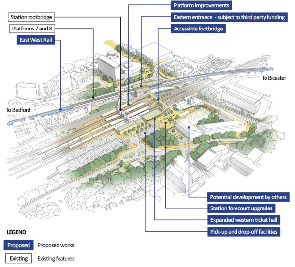
Figure 7: Aerial visualisation of Bletchley station
Design development in this route section
4.5.4 Passing loops
The designs for two new freight passing loops at Islip and Middle Claydon have been further refined in response to feedback about the railway’s ability to accommodate more trains, as well as concerns for flood risk in these areas. In both cases, we’re considering lengthening the loops so that freight trains can enter and exit at higher speeds allowing passenger trains to move through the section without delay. The designs have also been updated to include balancing ponds to manage additional drainage needs. Maintenance routes and compounds are also being considered to provide access to replace the new track equipment when required.
Through design development, we’re considering lengthening the passing loop at Islip to the east, but maintaining a buffer from the former Oddington level crossing to reduce noise impacts for residents. We’re currently considering the design of the drainage ponds and accesses required at the Middle Claydon and Islip passing loops to minimise impact on adjacent woodland and marshland habitat.
More details will be provided when we consult in 2026.
4.5.5 Oxford Parkway
At Oxford Parkway we’ve continued to engage with stakeholders and the local authority to ensure our proposed station upgrades align with the needs of the significant planned development in the area. We’re working on designs for improved active travel facilities.
We’re considering rerouting our planned construction access at Oxford Parkway and remove the need to use the Water Eaton Bridleway, following concerns raised about the impact of construction traffic on this public right of way.
We’re also considering the need for and design of a train turnback siding to the south of Oxford Parkway. This facility would increase the resilience of the planned railway operation by allowing westbound trains to turn back and travel east without going to Oxford. Work is ongoing to confirm what is needed to support the EWR train service.
More details will be provided when we consult in 2026.
4.5.6 Winslow
In response to concerns raised by residents and developers in the Verney Junction and Winslow areas, we’re looking to simplify the design of planned utility diversions and relocate construction access routes to reduce the overall amount of land required. We’re also considering relocating a planned traction power compound away from Furze Lane in response to concerns that this may impact plans for future housing developments in the area.
At Winslow station we’re assessing the impact of increased future demand and the potential to accommodate longer trains in the future. We’re also assessing the potential for new walking and cycling routes to improve access to the station from Buckingham Road.
More details will be provided when we consult in 2026.
4.5.7 Bicester
In response to concerns about access to Bicester Village station, we’re considering developing the design of the station forecourt facilities to the south of platform 1. This would include provision of a bus stop, taxi and private car pick up and drop off and additional cycle parking facilities.
Respondents raised concerns about the impacts any changes to the level crossing would have on the wider road network. Since the last consultation we’ve carried out further traffic modelling and we’re developing proposals for junction improvements aimed at reducing the delays to vehicle journeys across the area.
More details will be provided when we consult in 2026.
4.5.8 Environmental mitigation
We’re actively refining our design to minimise environmental impacts, including the position of permanent infrastructure such as drainage ponds to avoid more sensitive ecological habitats. We’re currently reviewing the proposed utility diversions in the vicinity of Alchester Scheduled Monument, which was raised by respondents as a site of demonstrable value in our most recent consultation.
During Connection Stage 1, several noise barriers were constructed to minimise disturbance from railway activity in residential areas. In response to feedback raising concerns about noise impacts in our most recent consultation, we’re undertaking further noise modelling exercises to identify areas where additional noise barriers may be required to reduce noise impacts from railway operations, including along the railway between Oxford and Oxford Parkway and in several areas around Bicester and Bletchley. As we progress our design, we’ll continue to assess and identify areas that may need noise mitigations.
As part of our commitment to deliver Biodiversity Net Gain and address visual impacts, we’ve identified opportunities to create woodland areas around new railway structures, including the Oxford Parkway turnback and associated maintenance compound, and the Islip and Middle Claydon passing loops. This woodland would provide both ecological habitat and visual screening for nearby receptors.
4.6 Fenny Stratford to Kempston (Marston Vale Line)
This 23-kilometre (14 mile) section of EWR runs between the Saxon Street dual carriageway in Fenny Stratford and Ampthill Road in Kempston. This covers the majority of the Martson Vale Line (MVL) from Bletchley to Bedford. Our proposals for this section seek to improve connectivity and support opportunities for new homes, as well as providing access to new developments including the South East Milton Keynes Strategic Urban Extension, Marston Valley development and the proposed Universal resort south of Bedford.
Within this chapter we provide updates on the following proposals:
- Marston Vale Line stations and train services
- Ridgmont station
- Stewartby station
- Bow Brickhill level crossing
We also provide design development updates on the following topics:
- Fenny Stratford twin tracking
- Ongoing station development
- Level crossings
- Passing loops
- Environment mitigation
An overview of the updates is shown in Figure 8.
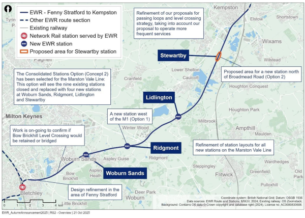
Figure 8: Map illustrating the Fenny Stratford to Kempston route section
Proposal updates in this route section
4.6.1 Marston Vale Line stations and train services
What we presented at our 2024 non-statutory consultation
We proposed two options for how the MVL could be upgraded to serve local communities and new developments in this area:
- Existing Stations Option (Concept 1a) - keeping all nine existing stations along with the relocated Bedford St Johns station and the Bletchley to Bedford train service as it operates today. Two additional services would operate between Oxford and Cambridge calling at Woburn Sands, Ridgmont, Lidlington, Stewartby and Bedford St Johns. Stewartby would also see two additional services to and from Cambridge.
- Consolidated Stations Option (Concept 2) - replacing the nine existing stations with four new, larger, easy-to access stations at Woburn Sands, Ridgmont, Lidlington and Stewartby, along with the relocated Bedford St Johns station. These stations would be served by three trains an hour in each direction, all of which would continue onto Cambridge. Stewartby would also see one additional service to and from Cambridge.
What you told us
We asked respondents to share their preference between Concept 1a and Concept 2, as well as giving the choice to respond with ‘No preference’ or ‘Other’. We also provided respondents with the opportunity to provide comments about this proposal. The feedback we received is summarised below.
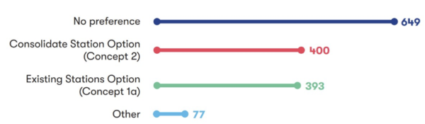
Figure 9: Numerical breakdown of responses to question 7a
A total of 1,519 respondents responded to this question. Just over half (52%) of respondents expressed a preference for one of the options, with an almost equal split between Concept 1a (26%) and Concept 2 (26%). Meanwhile, just under half (43%) expressed ‘No preference,’ whilst 5% indicated ‘Other’.
Some respondents in support of the Existing Stations Option (Concept 1a) highlighted the convenience of having stations within walking distance, noting this as a key factor in maintaining sustainable access to the railway. It was also mentioned that this option could avoid the environmental impacts associated with delivering new stations. Additional feedback included the historical and local importance of existing stations and the potential to support additional housing development nearby and suggestions to retain specific stations.
Respondents who opposed Existing Stations Option (Concept 1a) raised a range of concerns. Some felt that retaining all stations could lead to longer rail journey times and limit opportunities for freight movement. Others raised the risk of increased congestion and queueing at level crossings due to frequent train movements. Some respondents observed that existing stations were often underused and highlighted a general lack of supporting facilities such as parking or cycle storage and accessibility features. However, others felt that enhancing the reliability and connectivity of these stations could increase their usage, and they proposed various measures to improve service efficiency, including the introduction of limited-stop services.
A large number of respondents voiced general support for the Consolidated Stations Option (Concept 2), many of whom said that a smaller number of new stations would improve journey times. A small number of respondents highlighted that this option would be beneficial for the local economy, including potentially enabling concentrated investment in modern facilities and, due to these factors, make the railway more attractive to new users.
There were also a large number of respondents who expressed criticism for the Consolidated Stations Option (Concept 2). Several respondents expressed concern that having fewer stations could lead to increased car dependency, due to longer travel distances to stations and the need to deliver effective supporting active travel measures. The higher cost of building new stations in contrast to retaining the existing stations was also raised by a small number of respondents. Respondents highlighted the importance of door-to-door connectivity measures to support access to stations irrespective of which option was to be taken forward.
How we’ve updated our design proposals
Taking account of feedback from the consultation and ongoing engagement with local stakeholders, we’ve continued to shape our proposals for stations and services along the MVL. This work has helped us better understand the benefits of each option and led to a decision to move forward with the Consolidated Stations Option (Concept 2).
Stations on the MVL are spaced an average of only 1.7 miles apart and they are among the least used stations in the country. This appears to be due to:
- The locations of existing stations relative to local communities, destinations or planned development.
- The inaccessibility of stations, which offer minimal parking, public transport links, and lack of walking and cycling connections.
- Slow, low frequency train services, taking 44 minutes to travel the 17 miles between Bletchley and Bedford, which are often delayed or suspended.
- No direct connections to major employment centres like Oxford, Cambridge or London.
- Basic station facilities which frequently lack shelter, level access, shops or safe ways to cross between platforms.
Overcoming these barriers is essential to encouraging people to travel on EWR. However, doing so at every station along the line is extremely challenging because:
- Many of the existing station locations are physically constrained by surrounding housing, businesses, natural features and other land uses. As a result, we would need to relocate the stations to accommodate longer EWR trains and to provide new facilities, some of which are required for safety.
- Stopping some or all EWR trains at all existing stations would hamper route-wide journey times and limit our ability to deliver direct services beyond the MVL (e.g. to Cambridge), which would make EWR services less attractive to the majority of passengers. It would also create a bottleneck in rail capacity and make it harder to run trains across the mainlines we intersect with. So far, we’ve been unable to develop a timetable which would make this possible.
- Even if we overcame the above challenges, providing these upgrades at all ten stations would require significant public funding despite the low number of existing users and limited evidence to suggest demand would increase in locations like Aspley Guise, Millbrook and Kempston Hardwick.
Our proposed approach
Given these constraints, we’ve been working to understand how passengers currently use the railway and where future development is anticipated to come forward. This analysis has confirmed that to serve the region effectively, we should provide a spread of modern, well-equipped stations across the region around the following areas:
- Woburn Sands - supporting the existing community and nearby developments including the south-east Milton Keynes Extension and East of Wavendon Strategic Urban Expansion.
- Ridgmont - serving Brogborough, Aspley Guise, Ridgmont, the M1 motorway and surrounding development opportunities.
- Lidlington - supporting the village and the nearby Marston Valley development.
- Stewartby - supporting Stewartby village and providing access to local developments including the proposed Universal resort and the Stewartby Brickworks consented housing development.
At our most recent consultation, we established the need to relocate Woburn Sands and
Lidlington in order to expand them. With this proposal update, we’re also confirming our intention to relocate Ridgmont and Stewartby stations. For more information, see Chapter 4.6.2 (Ridgmont station) and 4.6.3 (Stewartby station).
In each case, we’ve considered whether to rebuild these stations in the existing locations or relocate them. Whilst retaining the existing stations in their current locations would offer some advantages, relocation is necessary to:
- Avoid impacts on surrounding houses, businesses, greenspace, future developments and other land uses.
- Optimise the location of these stations to support both current communities and future growth.
Delivery of these stations will require significant investment on behalf of the taxpayer and as a consequence, we’ll be continuing to explore third-party funding opportunities to enable their full delivery.
More details of our proposals will be provided when we consult in 2026.
Stations outside the Consolidated Option
Based on consultation feedback and ongoing engagement, we recognise the importance to local residents of those stations which would not be retained in this option – Fenny Stratford, Bow Brickhill, Aspley Guise, Millbrook and Kempston Hardwick. At present, these stations are not designed to safely support the operation of EWR services, requiring either significant upgrades or rebuilds. This creates a number of issues because of the constraints around the stations:
- At Fenny Stratford, adding a northern platform would require demolishing nearby businesses and even minor platform extensions would likely require rebuilding Watling Street bridge. There is also very limited space to provide additional facilities such as car parking, which would restrict the stations access and future usage.
- At Bow Brickhill, we’re determining whether we need to provide a new road bridge which would split the existing station in half. While we’ve explored how the station could be relocated around this bridge, we’ve found that it would not be possible to expand the station without impacting neighbouring properties, businesses and developments. The overbridge itself could also act as a physical barrier to people trying to reach the station from its opposite side. Without space for essential facilities, like parking and drop-off areas and bus connections, it is likely that passenger numbers would remain low, even with development to the south and south-east of the station.
- At Aspley Guise, we would need to provide longer, wider platforms. This could be delivered using the existing platform layout which is split by the level crossing or with platforms opposite each other on one side of the level crossing (east or west). Either of these solutions would require the demolition of adjacent houses. The relocation of Ridgmont station to a more central location between Aspley Guise, Brogborough and Ridgmont will help deliver a station for the Aspley Guise community without the demolition of properties as identified above.
- At Millbrook, extending and widening the platforms would be extremely difficult without impacts on the Grade II listed Station House and the edge of the Forest of Marston Vale, both of which are protected and sensitive areas. These constraints combined with the isolated location of the station also means usage of the stations unlikely to increase.
- At Kempston Hardwick, operating a second station would not be practical due to its close proximity to the proposed Universal resort and the relocated Stewartby station.
In addition to the site-specific constraints, upgrading and rebuilding these stations would require significant additional public investment. Given the low number of current users and the physical constraints that might limit future growth, only a small number of people would benefit from this investment. We consider these limited benefits would not justify the costs and the impacts on neighbouring properties and businesses and that our proposal to consolidate stations would provide better services and facilities along the route as a whole.
Supporting communities affected by station closures
We understand that, despite these issues, Fenny Stratford, Bow Brickhill, Aspley Guise, Millbrook and Kempston Hardwick stations are valued by local residents, businesses and services, and form part of the area’s heritage. That’s why we’re working with communities, key stakeholders, local councils, our rail partners and developers on:
- Ways we can protect the listed buildings adjoining the existing stations at Fenny Stratford, Woburn Sands, Ridgmont and Millbrook.
- Opportunities to repurpose these stations for new community uses.
- How we can maintain existing public rights of way. Where temporary closures or diversions are needed we would provide a replacement route before the closure takes place.
- The delivery of two new road bridges prior to 2030 which will:
- Provide a new road connection west of Woburn Sands as part of the South East Milton Keynes Strategic Urban Extension, which it is intended will be in place before further level crossing works are undertaken|
- Replace the level crossing at Marston Road. - A package of door-to-door connectivity measures to connect people who currently use the railway with new stations. Whilst the list of measures remains under development, in addition to providing car parking at our stations, we will seek to:
- Work with third-party funding contributors to deliver a new eastern entrance at Bletchley station linking into active travel routes which would make it easier for people to reach local bus services, the town centre and Fenny Stratford.
- At the new Woburn Sands station, provide walking, cycling and road routes which make reaching this station easy from all directions, particularly from Browns Wood and Bow Brickhill. Additionally, we’re planning to make the station bridge publicly accessible so that pedestrians can continue to cross the railway in this location despite the proposed closure of Fisherman’s Path level crossing.
- At the new Ridgmont station, provide walking, cycling and road active travel routes in all directions including towards the east and the existing station location making use of the footpath under the M1 just north of the railway corridor.
- At the new Lidlington station, broadly in the same location as the existing Piling Farm South level crossing, provide entrances on the north and south side of the railway. These would be accessible via a new active travel route running along the north side of the railway from the centre of the village and from the south via Lombard Street and the connecting footpath. Additionally, we’re seeking to connect people using the existing Millbrook station to Lidlington via the Forest of Marston Vale active travel route to the north of the railway, and by working with the developer of the Marston Valley proposals to create a new route between Lidlington station and Marston Moreteyne.
- At the new Stewartby station, deliver walking and cycling routes, alongside work by Universal, Bedford Borough Council and other stakeholders, which support access to Kimberly College, Stewartby village and the Marston Vale Country Park.
We’re also working with local authorities and bus operators to discuss how we can make new stations more accessible by public transport. We're designing each of our new stations with bus facilities to make it quick and easy for all users to use the bus before or after their train journey.
Lastly, as outlined in Chapter 4.6.7, we’re looking again at some of our proposals for level crossings given our decision to increase the frequency of train services, and the potential changes to local traffic patterns as a result of Universal’s proposals. This work is ongoing, and while it is not yet possible for us to confirm which level crossings might be affected and how, we will only propose further level crossing closures where this is necessary for safety or congestion reasons.
We understand how important the remaining level crossings are in this area, particularly those which sit central to local communities such as at Fenny Stratford, Woburn Sands and Lidlington, and we’re focused on how to maintain the connectivity they provide if more closures are required.
We'll share more details on this when we consult in 2026.
4.6.2 Ridgmont station
What we presented at our 2024 non-statutory consultation
We explained how Ridgmont station isn’t currently big enough to cope with the number of passengers anticipated when EWR services are introduced and, under the Consolidated Stations Option, we proposed two options for Ridgmont station to help with this:
- Option 1 - relocate the station to the west of Bedford Road and locate station facilities and car parking north of the railway.
- Option 2 - redevelop the station on its current site, locating station facilities and car parking on both sides of the railway.
What you told us
We asked respondents to share their preference between Option 1 and Option 2, as well as giving them the choice to respond with ‘No preference’ or ‘Other’. We also provided respondents with the opportunity to provide comments about this proposal. The feedback we received is summarised below.
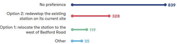
Figure 10: Numerical breakdown of responses to question 8a
A range of views were expressed about the proposed location of the station by 1,321 respondents, with the majority (63%) expressing no preference. A quarter (25%) were in favour of rebuilding the station on the current site (Option 2). Out of the remaining respondents, 9% opted for its relocation west of the M1 (Option 1), whilst 3% indicated ‘Other’.
Several respondents who supported rebuilding the station in its current location (Option 2) said it is currently well-used by commuters. A few respondents noted that it is in a good position to serve existing communities due to its strong road connectivity via the M1 motorway and other major roads, (A421, and A507).
Some respondents were concerned about how people would access the station and local workplaces by foot and cycle if it were relocated. A few respondents questioned whether relocation would be cost-effective and efficient, and said it could cause disruption. Others expressed their attachment to the current station and raised concerns about how relocating the station would impact the Ridgmont Station Tea Room and Heritage Centre.
A small number of respondents who supported the station’s relocation west of the M1 (Option 1) stated that it offered more opportunities to futureproof the station, create a modern interchange and support future housing and commercial development north of Aspley Guise. Further comments felt that relocating the station could be more sustainable than Option 2, as long as it is supported by appropriate infrastructure such as lighting, cycle paths, and public transport connections.
A few respondents raised concerns about the environmental impact of relocating Ridgmont Station (Option 1) to the west of Bedford Road, including the potential loss of green space and productive agricultural land, as well as broader concerns about harm to the countryside and land designated as green belt.
Further comments expressed concern about flood risks associated with the proposed access road and intrusion on areas designated for environmental mitigation. A few respondents suggested that options for retaining the building should be explored due to the heritage value of the Grade II listed station building.
A range of suggestions for Option 1 were raised including constructing passing loops, extending platforms to support longer trains, and developing a compact freight terminal to serve nearby warehouses.
How we’ve updated our design proposals
Taking account of consultation feedback, we’ve continued to work on our designs for the Ridgmont station options, including proposals for how people can use active travel to reach local destinations from the station.
We’ve been collecting and reviewing station user data and working with Central Bedfordshire Council and National Highways to understand how best to integrate each option with the wider transport network.
We’ve been collaborating with local stakeholders including Homes England, Central Bedfordshire Council and others to explore how the station could support local development plans, as well as the value of providing a park and ride facility next to the M1 for station users.
Using this work, we’ve undertaken a careful comparison of the two station options to consider the relative advantages and disadvantages of each. Based on this work and taking account of consultation feedback, we’ve decided to build a new Ridgmont-Aspley Guise station west of the M1 as in Option 1. This location was chosen for the following reasons:
- Relocating the station (Option 1) offers a clear opportunity to unlock new homes north of Aspley Guise.
- Expanding the station at its current location (Option 2) would have significant impacts on neighbouring businesses and landowners. In comparison, relocating the station west of the M1 (Option 1) would have less impact on landowners, although it would have a minor impact on green belt land south of the railway corridor.
- A relocated station (Option 1) would be more centrally located between Brogborough, the Marston Gate Logistics Centre, Ridgmont Station Tea Room and Heritage Centre, Ridgmont, Apsley Guise and development to its north. This means that it would serve a much larger population within 2 kilometres and 5 kilometres compared to the existing site (Option 2).
We do recognise that moving the station westward would increase walking distances to Brogborough, the Marston Gate Logistics Centre and Ridgmont Station Tea Room Heritage Centre, and that the M1 represents a barrier to walking and cycling. As a result, as part of our door-to-door connectivity strategy, we’re looking to provide a walking and cycling route under the M1 parallel to the railway incorporating the existing public right of way. We're also seeking to explore opportunities for connecting bus services with bus operators.
More details will be provided when we consult in 2026.
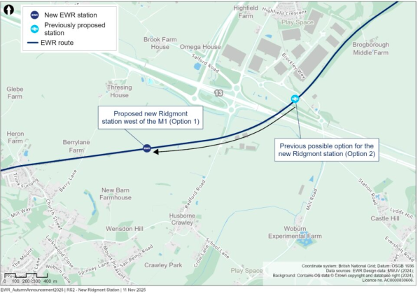
Figure 11: Map indicating the proposed location of Ridgmont station
4.6.3 Stewartby station
What we presented at our 2024 non-statutory consultation
We explained why the current Stewartby station isn’t equipped to accommodate EWR services and that we need to relocate and expand the station irrespective of the wider consolidation of stations.
We proposed two options for the relocation of the station:
- Option 1 - relocate the station 300 metres north of its existing location, with the station and car park located to the east of the railway. Three new platforms would be built: a side platform and an island with two platforms. Access to the station would be from Stewartby Way on the eastern side of the railway.
- Option 2 - relocate the station around 1 kilometre north, to just north of Broadmead Road. Three new platforms would be built: a side platform and an island with two platforms. The station and car park would be located east of the railway. Access to the station would be from Broadmead Road on the eastern side of the railway.
For both options, it was assumed that the Green Lane level crossing would be retained and equipped with new safety features. We also said that we would be reflecting on how to make access to each option as easy as possible.
What you told us
We asked respondents to share their preference between Option 1 and Option 2, as well as giving the choice to respond with ‘No preference’ or ‘Other’. We also provided respondents with the opportunity to provide comments about this proposal. The feedback we received is summarised below.
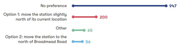
Figure 12: Numerical breakdown of responses to question 9a
A range of views were expressed about the proposed location of the station by 1,268 respondents, with three quarters (75%) expressing no preference for any option whilst 16% of respondents were in favour of Option 1. Only 4% of respondents opted for the station’s relocation to Broadmead Road (Option 2) whilst 5% of respondents indicated ‘Other’.
Several of those who supported Option 1 stated that this would better support continued connectivity to Kimberley College, Stewartby and the Marston Vale Millennium Country Park, minimising disruption to existing users, whilst also making use of brownfield land.
Respondents also expressed a range of views about relocating the station to Broadmead Road (Option 2). Several respondents highlighted that it would better support Bedford Borough Council’s Local Plan 2040 and upcoming development, such as Universal’s proposals and Kempston Hardwick New Settlement. Others said Option 2 would be better connected with Wootton village by foot and cycle than Option 1.
While some respondents felt that Option 1 may have less ecological impact compared to Option 2, the loss of green space and the broader environmental impacts of Option 1 were highlighted as concerns by a few respondents. There was concern about potential operational challenges at Rookery South Pit, such as a loss of vehicular access. Some respondents indicated that Option 2 was preferred in terms of landscape and sustainability.
A large number of respondents suggested that there should be detailed consideration of the Universal resort proposals within our plans for the location of Stewartby station. However, others expressed concerns that deciding to locate the station close to the Universal resort was premature as Universal’s proposals hadn’t yet received planning consent.
How we’ve updated our design proposals
Taking account of consultation feedback, we continued to work on our designs for the Stewartby station options, including proposals for how people can use active travel to reach local destinations from the station. We undertook a careful comparison of the two station options to consider the relative advantages and disadvantages of each. Based on this work and taking account of consultation feedback, we concluded that a new Stewartby-Kempston Hardwick station would best be located north of Broadmead Road (Option 2) as:
- The location of Option 2 further north aligns with Bedford Borough Council’s Local Plan 2040, which sets out aspirations for new housing and businesses in the surrounding area.
- The land that would be needed for Option 1 already has planning consent for development and this means it would carry a high land price. In contrast, the land needed for Option 2 would offer better value for taxpayers.
- Option 2 avoids significant impacts on the development of the Stewartby Brickworks site (which is near to the location for Option 1).
- Option 2 offers better integration with the local road network, making it easier to access the station.
- Bedford Borough Council, the Local Planning Authority for Stewartby station, have expressed support for Option 2.
Since this exercise, Universal’s proposals for a resort in this area have also progressed and now, taking these into account, we believe the case for this relocation is even stronger given the opportunities to support sustainable travel to and from this international destination.
Given Universal’s proposals are still emerging, we’re working with them and other stakeholders to determine the design and exact position of the station. We would like to provide reassurance that as we progress this work, we are focused on not just integrating the design for this station with the wider development proposals but also maintaining access to the strategic road network and local destinations including Kimberley Sixth Form College and Stewartby. For more details on how we’re planning to make this station accessible, see Chapter 4.6.1.
Once we have undertaken this work, we will provide further information when we consult in 2026.
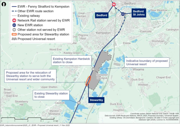
Figure 13: Map illustrating the proposed area for the relocation of Stewartby station
4.6.4 Bow Brickhill level crossing
What we presented at our 2024 non-statutory consultation
We explained that we were still carrying out traffic modelling work to determine whether Bow Brickhill level crossing would need to be closed. We said that if closure was required, our proposal would be to replace it with a new road bridge running parallel to the existing road that connects into the roundabouts on Bradbourne Drive and Station Road.
What you told us
Many respondents wanted us to keep the Bow Brickhill level crossing, with a small number highlighting how the crossing manages the traffic flow. However, several respondents said that if the crossing could not be retained, they would support the construction of a new road bridge to reduce the congestion that could result from anticipated housing and employment growth.
However, there were concerns from a small number of respondents that the new road bridge may create more traffic in the local area as the road is being increasingly used to access the A5. Some comments also expressed concerns about potential impacts such as air and noise pollution, due to increased traffic, as well as visual intrusion and disruption during construction. A few respondents also said that the new road bridge may have impacts on operations and parking facilities at Red Bull Racing.
A range of mitigation measures were suggested in the case of retention, including reducing the road traffic speed limits, constructing a Redway to support mode shift towards walking and cycling, creative solutions to reduce the amount of land required and moving the bridge further east. Some respondents suggested closing the level crossing and road entirely and instead rerouting traffic via the A5 or other existing routes.
How we’ve updated our design proposals
With the decision to adapt the project to deliver more passenger services, we need to reassess whether the crossing could be retained under this new scenario.
We’ve also compared how traffic patterns and congestion in this area would change if the level crossing were closed and replaced either with a road bridge or a traffic diversion via the A5. If the level crossing does need to be closed, our modelling shows that a bridge would be required as diverting traffic would increase congestion at a number of local junctions, including Kelly’s Kitchen, in ways we cannot mitigate effectively.
As a result of the above, and while we assess whether the level crossing needs to be closed, we’ve been focusing on developing our design for the road bridge. In response to feedback, this has included refining our designs to minimise impacts on local properties and businesses and considering amendments to junctions north and south of the level crossing to reduce traffic congestion and land take.
Looking ahead, we will be carrying out further traffic modelling, assuming the bridge is in place, this will help us to confirm how best to integrate the bridge into the highway network, if it is needed, and understand the full extent of highway mitigations that would be required in the surrounding area. New traffic data will be considered in our design.
More details will be provided when we consult in 2026.
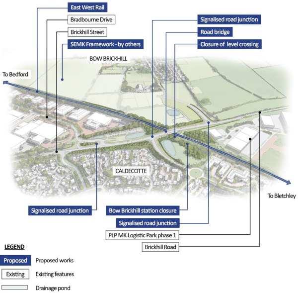
Figure 14: Aerial illustration of proposed Bow Brickhill level crossing
Design development in this route section
4.6.5 Fenny Stratford twin-tracking
We’ve continued to develop the design in this area in response to feedback which raised concerns about construction impacts.
The existing railway corridor west of Saxon Street, passing through Fenny Stratford station and extending to the A5, currently operates as a single track. To accommodate the EWR train service specification, we propose to construct a second track. This new track would begin west of Saxon Street and tie into the existing twin-track section east of the A5.
Since our most recent consultation, the demolition of the southern-most railway bridge over Saxon Street will now be undertaken earlier by Network Rail. This change has enabled us to consider removing the previously proposed construction and logistics compound. In this area, we’re also looking to consolidate the sub-surface drainage attenuation tanks. This would reduce disruption to surrounding businesses.
We’re also considering lowering the tracks beneath Watling Street to future-proof the route for potential electrification. This approach would mitigate the risk of future disruption and remove the need for bridge demolition or modification should electrification be introduced.
Mitigation proposals continue to be developed throughout the area. Near the River Ouzel, we’re refining bridge pier and abutment designs, construction access routes, and compound locations to minimise impacts on the floodplain.
More details will be provided when we consult in 2026.
4.6.6 Ongoing station development
With the decision to move forward with the Consolidated Stations Option (Concept 2) and the chosen Ridgmont and Stewartby station locations, we’re now focusing on refining our designs for all stations proposed in this route section.
Our aim is to deliver high-quality facilities which integrate well with their surrounding areas and promote local development, and to make these accessible through a combination of active travel measures, car parking and bus connections under consideration as part of our door-to-door connectivity strategy. Supplementing this work, our environmental mitigation is being refined to provide screening between adjacent villages and the proposed station infrastructure.
The designs for Woburn Sands and Lidlington stations presented at our most recent consultation continue to evolve in line with these aims.
More details will be provided when we consult in 2026.
4.6.7 Level crossings
At our most recent consultation, we provided an updated level crossing strategy for the MVL in which we sought to balance the need for north-south connectivity across the line with the safety implications of running more frequent trains at higher speeds.
We need to reconsider some of our proposals for level crossings following our decision to increase the frequency of train services as this will increase barrier downtimes and the risk of misuse. Additionally, we need to consider how local traffic patterns may change as a result of Universal’s proposals and factor this into our strategy, particularly in the Stewartby area.
As this work is still ongoing it is not possible for us to confirm which level crossings might be affected and how. However, in developing the proposals, our intention is only to propose further closures where this is necessary, for example should there be issues relating to safety or congestion. Understanding the importance of the remaining level crossings in this area, we will also be focused on how we can adequately maintain the connectivity they provide if this is required.
More details will be provided when we consult in 2026.
4.6.8 Passing loops
At our most recent consultation, we noted that we needed passing loops on the MVL to enable westbound and eastbound passenger services to pass slower trains including freight without delay. We presented several options where we could build these, with the final location being influenced by final station locations.
While decisions on station locations have been made as outlined earlier in this report, our proposal to change the frequency of our services means we need to continue to assess how many passing loops will be required on the MVL and the most suitable locations of these loops.
More details will be provided when we consult in 2026.
4.6.9 Environmental mitigation
Since our most recent consultation we’ve been actively refining our design to minimise environmental impacts, including reviewing the requirements for utility diversions, as well as relocating infrastructure such as compounds. We’ve been developing our environmental mitigation proposals to be reflective of the latest design.
We’ve looked more closely at how proposed developments along the MVL could affect our environmental mitigation proposals. Where we can, we’ve also tried to integrate third-party environmental mitigation plans into our design.
We’re considering rationalising the location of drainage ponds and including permanent flood compensation areas, with suitable environmental mitigation designed alongside these features. This has included looking to remove some drainage ponds and their associated environmental mitigation, notably within the footprint of the Marston Vale Millennium Country Park. This was identified as a particular concern in consultation feedback.
At our most recent consultation, we presented indicative noise barrier locations to minimise disturbance from railway activity in residential areas. We’ve since undertaken further noise modelling exercises with a view to confirming the exact locations of noise mitigation.
We’ve also further considered the land requirements to construct the project and have identified what existing vegetation can be either enhanced or retained. Overall, across the route section since our most recent consultation we’ve considered feedback from landowners and have reduced the land taken specifically for environmental mitigation, notably in the vicinity of Aspley Guise and Ridgmont.
4.7 Bedford
This section of EWR runs north from Ampthill Road in Kempston to Clapham Road in Clapham Village, next to the River Great Ouse. It is approximately 5.4 kilometres (3.4 miles) long.
Within this chapter we provide updates on the following proposals:
- Bedford St Johns station
- Bedford station
We also provide design development updates on the following topics:
- Highways works in Bedford
- Alignment and gradient of the railway
- Environmental mitigation
An overview of the updates is shown in Figure 15.
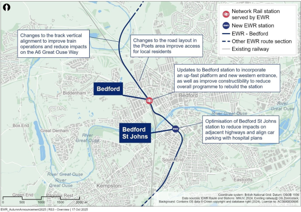
Figure 15: Map illustrating the Bedford route section
Proposal updates in this route section
4.7.1 Bedford St Johns station
What we presented at our 2024 non-statutory consultation
We proposed making improvements to the section of the MVL to the south of Bedford, relocating Bedford St Johns station closer to Bedford Hospital to a location between Ampthill Road and Cauldwell Street. This site has the space that will be needed to accommodate the new EWR services. The new location for Bedford St Johns station will provide frequent train services for people travelling to Bedford Hospital, benefitting patients, hospital staff and visitors. We’d previously confirmed our preference for this station location in our Route Update Announcement in 2023.
What you told us
Many respondents supported our proposals for the relocation of Bedford St Johns station, saying that they align with Bedford Borough Council’s regeneration plans.
Respondents said it would be important to make sure that the new station design prioritises accessibility, sustainability, connectivity to the hospital and safety. They also said it should be connected with wider transport networks, including bus routes.
Some respondents suggested the relocation of Bedford St Johns and the proposed car parking changes could benefit the hospital and makes it easier to reach for pedestrians, although a large number of respondents were worried that the new station would be hard to reach for some, given it would be on the other side of the tracks from the hospital.
Several respondents also questioned whether it is necessary to relocate the station, given it is close to the main Bedford station, and whether there is enough demand for rail access to the hospital. Respondents suggested alternative proposals, which included removing Bedford St Johns station from the EWR proposals entirely; relocating it to a site south of Bedford in between Thameslink and East Midlands Railway which could also be used for sidings or a turnback facility for additional platforms near major arterial roads; or integrating it with Bedford station.
Several respondents supported the multi-storey car park proposal that we shared at the consultation, saying that they thought this would increase parking capacity, particularly for Bedford Hospital. However, many respondents were concerned about the impacts that the proposed car park would have on the hospital, including making it more difficult to find a parking space due to it also being used by rail passengers. They were also worried about land that is being considered for expansion of the hospital being used for the car park.
A few respondents did not like the idea of a multi-storey car park being built next to a train station as they felt it would not promote active travel and sustainable transport, such as buses. Respondents emphasised the need to minimise disruption to hospital operations and local businesses and to make sure there would be sufficient capacity to meet both hospital and commuter needs during construction and operation of the car park.
Suggestions were made about what features the car park should include, such as a secure drop off and pick up area, free parking for NHS staff and electric vehicle charging points. Respondents also requested that it is fully operational before any existing parking is removed and that the design should have a reduced visual impact than what we shared during the consultation. They also said that we need to engage with individual businesses and organisations to agree limits on environmental pollution.
How we’ve updated our design proposals
Since our most recent consultation, we’ve been working with Bedfordshire Hospitals NHS Foundation Trust, Bedford Borough Council and Network Rail to bring our development plans for the area together. We all share the aim to create a station that’s easy to use, accessible and serves the hospital.
We recognise that respondents questioned the necessity of relocating Bedford St Johns station. We understand the importance of maintaining connectivity and station access for local communities.
After detailed technical assessments, we’re still planning to relocate the station due to significant infrastructure constraints at the current site. The existing railway alignment will only enable trains to travel at speeds of up to 15 mph, which is insufficient for the revised EWR and freight timetables. To deliver a reliable and efficient service, trains need to be able to travel at speeds of up to 40 mph, which isn’t possible using the current infrastructure. Relocating the station means we can meet these operational requirements whilst also supporting the area’s redevelopment and enabling Bedford St Johns station to become a key transport hub serving central Bedford.
To address concerns about how people will travel to and from the relocated Bedford St Johns station, we’re planning to include interchanges to the bus network and connections to cycle and pedestrian routes in the design. We would also build a pedestrian bridge, including lift access, to cross to and from the station. This would link the hospital’s redevelopment plans with the development sites to the north-east of the station.
We see the new station being an important means of access to the hospital for staff, visitors and patients. Our current designs position the station in a way that would make access as easy as possible. We’ve also shaped our plans around the hospital’s expansion plans and the Bedford Borough Council’s vision for the area.
Following discussions with the hospital, we’re planning to build a new multi-storey car park next to the hospital’s proposed expansion on the north side of Britannia Road. We’re also proposing to provide additional disabled parking spaces for station users as well as electric vehicle charging points. We would make sure that temporary parking is in place before the existing parking facilities are removed.
The new Bedford St Johns station would be located on railway land between Ampthill Road and
Cauldwell Street bridges. We’ve found possible ways to avoid demolishing Ampthill Road and Cauldwell Street bridges, but we still need to do more checks and assess their condition to see if they can stay in place while the track is lowered.
If we do need to demolish and reconstruct the bridges, we’ve reviewed our plans and have been able to reduce the amount of reconstruction work. This would reduce the impacts from this work on traffic movements in Bedford and the potential impacts to the entrance to the former Britannia Iron Works, a Grade II Listed Building. Using updated design standards, we’ve also been able to shorten the amount of road that would need to be realigned and avoid the permanent closures and temporary diversions we had planned before.
We understand that people are concerned about the potential disruption from construction works. We’ve redesigned the railway track, as it changes from single track to twin track at Bedford St Johns, to reduce disruption as much as possible. A major construction project such as EWR would inevitably bring some disruption to the town, and we would aim to minimise the impact from the construction work through continued engagement with stakeholders, local businesses and the communities we will be working in.
More details will be provided when we consult in 2026.
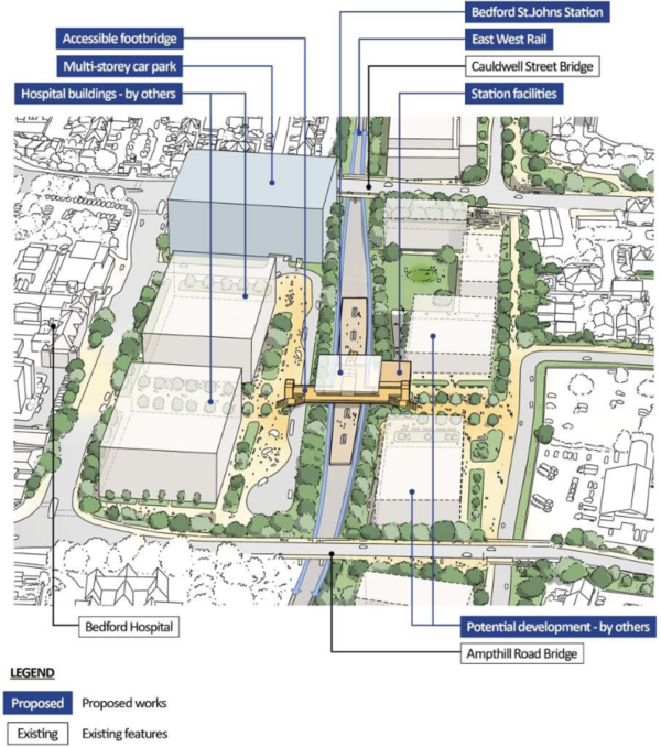
Figure 16: Aerial illustration of proposed Bedford St Johns station
4.7.2 Bedford station
What we presented at our 2024 non-statutory consultation
At Bedford station, we proposed a range of work including redeveloping the station building to provide Bedford with a state-of-the-art transport hub that connects different modes of transport, including frequent direct trains to Oxford, Milton Keynes and Cambridge, bus connections and walking and cycling routes. We shared our proposals to create a new station plaza, improving access to the town centre, building footbridges to improve connections to the station and building two new platforms.
What you told us
Respondents shared a range of views on our plans for redeveloping Bedford station, with a few questioning the cost and value of the investment. In contrast, the potential community benefits of the project were recognised by many respondents who suggested that it could help to improve the profile of the town, attract investment into Bedford and make Bedford a more appealing destination for work and leisure activities.
Concerns were raised about the affordability and reliability of rail travel, unpredictable passenger numbers and whether the proposed station redevelopment would make a real difference to the economic challenges in Bedford’s town centre. It was suggested that the project might encourage people to commute to other towns rather than supporting the local economy.
How we’ve updated our design proposals
The redevelopment of Bedford station would provide Bedford with a state-of-the-art transport hub that would connect direct trains to Oxford, Milton Keynes and Cambridge. By redeveloping Bedford station, we would be increasing capacity for passengers using not only the new EWR services but also the north-south Midland Main Line.
We are working on how the station would support bus connections and those walking and cycling to and from the station. Improvements to sustainable and active travel would make it easier for people to access the town centre and the riverside, helping to boost the local and regional economy, create new jobs and support businesses in and around the town.
In addition, we are considering the introduction of an up-fast platform which would improve interchange between train services east and west as well as north and south.
As well as the redevelopment of the station building, we’re proposing a new pedestrian plaza in front of the station with a clear pedestrian connection to the centre of Bedford along Midland Road. A western entrance would improve connectivity to existing and proposed residential properties in the Queens Park area.
Further, our latest proposals would relocate the new multi-storey car park from the east of the station, accessed from Ashburnham Road to a site to the west of the station, accessed from Ford End Road. A car park to the west of the station would reduce the visual impact for those on Ashburnham Road and maximise development opportunities near to the station. Since our most recent consultation, we’ve undertaken more detailed planning and construction analysis.
We’ve continued to develop the design of Bedford station to ensure it can meet the needs of passengers well into the future, including the increased demand from nearby developments such as the Universal resort. The updated plans are more ambitious and are intended to create long term benefits for Bedford town centre, including opportunities for wider regeneration.
Also, our work has shown that the space we had previously identified for the main construction compound, which is the central area used for material storage, the assembly of large components, and the coordination of construction activity, is not large enough to support the work that is required in a safe and efficient way. Our updated plans now include additional land at Ashburnham Road for the construction compound, which would allow for the safer and more efficient construction of the upgrades to Bedford station, reducing our construction programme significantly. This means we could reduce disruption in Bedford town centre caused by construction by up to three years.
We recognise that this is a significant change to what we shared at our most recent consultation.
We fully understand that the updated plans may cause concern for residents and businesses on Ashburnham Road who are now within the boundary for the project and so could be impacted, and we do not make these changes lightly. We’re committed to engaging with those who could be impacted openly and honestly to explain the reasons behind the changes, to listen to their views, and to work with them to understand and, wherever possible, reduce the impacts.
Chapter 3.3 provides more detail on our approach to land and property including support that may be available to those land and property owners and occupiers who could be impacted by our plans.
We’ve worked with Bedford Borough Council to fulfil their main aims for a redeveloped station: an up-fast platform and a new western entrance.
The new up-fast platform would allow southbound fast Midland Main Line trains to stop at Bedford, which would significantly improve Bedford’s north-south connectivity, while the new western entrance would improve access for residents in the west of Bedford, helping to unlock economic growth in this part of the town and connect to active travel routes. The introduction of the up-fast platform would also help reduce the noise impacts associated with fast trains passing through Bedford, which was a concern highlighted by respondents in our most recent consultation.
We’ve listened to residents, and have increased the amount of car parking for the station by planning for a new multi-storey car park which has less impact on residents. Our designs will include improved cycle and car parking and electric vehicle charging points.
As we refine our designs, we’ll promote integration of mixed-use development to enliven this gateway to the key areas in the town. We intend to retain mature trees on the site where practicable. We plan to reduce the risk of surface water flooding by introducing rainwater retention provision on the site.
To the south of Bedford station, Ford End Road remains unchanged as per the designs we shared at our most recent consultation. To the north of the station we’re still planning to extend Bromham Road bridge to make the additional space that’s needed to cross the two new EWR tracks that will run adjacent to the Midland Main Line.
More details will be provided when we consult in 2026.
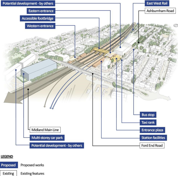
Figure 17: Aerial illustration of proposed redevelopment of Bedford station
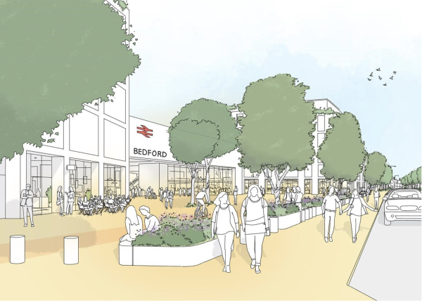
Figure 18: Illustration of proposed eastern entrance to Bedford station
Design development in this route section
4.7.3 Highways works in Bedford
Following feedback from our most recent consultation and further technical assessments, we’ve refined the highways designs in Bedford to address concerns about disruption to local roads during the construction of EWR.
We’ve described the proposed changes to Ampthill Road, Cauldwell Street, Ford End Road and Bromham Road earlier in this chapter. We’re also further considering the realignment of the A6 Great Ouse Way to help the design fit better in the surrounding area and reduce local impacts. These plans will be further refined as we continue our work on the design in this route section and we will share them when we consult in 2026.
In the Poets area we’ve listened to feedback concerning the proposed turning heads and cul-desac arrangements impacting Chaucer Road, Spenser Road, Milton Road and Sidney Road as shared at our most recent consultation. Whilst temporary cul-de-sacs would be necessary during the construction period, we’re considering our plans in response to feedback so that we can quickly reinstate the highway once the construction period has ended.
Our latest design improvements mean we can successfully introduce a single one-way lane at Chaucer Road and Spenser Road outside Spenser Court, and the corner of Milton Road and Sidney Road. This approach not only enhances traffic flow but also eliminates the need to acquire the garden on Milton Road, reducing impact on local residents and preserving community spaces. Due to the space required for the two additional EWR tracks north of Bedford, it will not be possible to reinstate both lanes of the road at these locations because the shape of the road would restrict sight lines around these corners, therefore we believe a one-way system would provide the safest solution.
There are several potential options for how this one-way system could operate, and we will engage with local residents as we continue to develop our designs.
More details will be provided when we consult in 2026.
4.7.4 Alignment and gradient of the railway
We’re considering how to make the tracks less steep north of Bedford station to make sure the trains run as efficiently as possible where the ground rises up as the railway heads towards Cambridge. In response to concerns about the impacts of building the six-track section of the route out of Bedford, we’ve confirmed our designs using revised survey data; this has not changed the land that we need to build and operate the railway.
We’re planning to make other minor changes to the gradient of the track along the Bedford section of the route to optimise the railway as much as possible.
More details will be provided when we consult in 2026.
4.7.5 Environmental mitigation
Since our most recent consultation we’ve developed our environmental mitigation proposals in the Bedford section taking account of the feedback we received and the updates we’ve made to the design. We’ve also looked at which utilities in the area may need diverting and whether we can relocate proposed infrastructure like construction compounds and drainage ponds.
We’ve reviewed our proposed locations for drainage ponds and we’re now including permanent flood compensation areas, with suitable environmental mitigation designed alongside these features. We’re considering the relocation of some drainage ponds and their associated mitigation, notably the drainage pond that was originally located in the fields north of Beverly Crescent, which would now be located on the east side of the railway north of the UKPN substation.
We’re also considering what other proposed developments in the area, such as the development at Fairhill, might mean for our plans for environmental mitigation.
4.8 Clapham Green to Colesden
This section of the route involves the construction of approximately 12 kilometres (7 miles) of new twin-track railway between Clapham Green (north of Bedford) and Colesden (north-east of Bedford). It includes bridges, embankments, cuttings, two railway passing loops near Colesden, and road and path realignments.
Within this route section we provide design development updates on:
- Alignment and gradient of the railway
- Highways and public rights of way
- Environmental mitigation
An overview of the design development updates is shown in Figure 19.
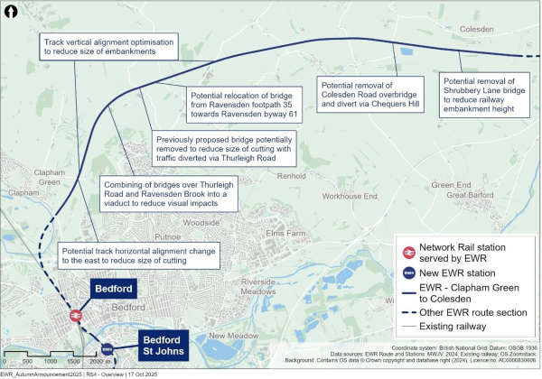
Figure 19: Map illustrating the Clapham Green to Colesden route section
Design development in this route section
4.8.1 Alignment and gradient of the railway
In response to feedback, we’ve been reviewing and making changes to our alignment and gradient proposals for this route section.
So that we can address concerns raised by respondents about reducing impacts on landscape character in the Ravensden Parish, we’re considering making the gradient of the railway less steep at locations including Sunderland Hill and between Clapham Green and Ravensden Brook. For example, the track near Sunderland Hill, which was previously a gradient of 1:80, would instead climb at a more gentle gradient of 1:120. This change means we could reduce the height of the embankment in this location which would have less of an impact on landscape and views.
To respond to concerns about the size and scale of the proposed cutting between Clapham Green and Clapham Park, we’re considering moving the proposed alignment of the railway between Clapham Green and Ravensden Brook to the east where it runs alongside Bedford and County Golf Club. This would allow us to reduce the depth, and therefore the width, of the cutting in this area by building the railway at a lower point in the hill.
We’re continuing to look at locations along the route where our plans could be optimised to improve railway operations, taking care to consider the impact of deep cuttings and high embankments in terms of land take, visual impact and transport of earth.
More details will be provided when we consult in 2026.
4.8.2 Highways and public rights of way
In light of feedback, and as a result of ongoing alignment and gradient work we’ve been conducting, we’re considering making changes to our plans for bridges in this area. For example, we’re now planning to raise the height of the track alignment in the Graze Hill area to reduce the size of the cutting. This means that the construction of an overbridge would no longer be feasible and so traffic would instead be diverted via Thurleigh Road.
Further east, in the Ravensden Brook area, we’ve responded to concerns about the visual impact of the embankments by combining the bridges over Thurleigh Road and Ravensden Brook into a viaduct. The current alignment of Thurleigh Road will not be impacted. Following changes we’ve made to the railway alignment, and to address concerns raised about the severance of Ravensden byway 61, we’re looking to relocate the proposed bridge away from Ravensden Footpath 35 further west to be closer to byway 61. This bridge would be for NMUs only, with the byway 61 realignment also remaining to the south of the railway to retain the link to Sunderland Hill.
In the Wilden area, we’re considering reducing the height of the railway at South Brook by up to 5 metres by removing the Shrubbery Lane bridge from our proposals.
In response to feedback asking us to reconsider the Colesden Road overbridge proposal because of the visual impact, cost and how much land it would take, we’re considering whether to remove it from our proposals and instead divert Colesden Road to the north of the railway to join in to Chequers Hill. To the south, Colesden Road would still be used for local access as well as for railway maintenance access.
More details will be provided when we consult in 2026.
4.8.3 Environmental mitigation
As we’ve continued to refine our designs in this route section, we’ve also updated our proposals for environmental mitigation, in light of survey information, initial preliminary outputs from the Environmental Impact Assessment process and in response to issues raised during our most recent consultation.
We’re considering changing the position of the River Great Ouse northern abutment and refining our plans for track drainage and access routes. This will avoid potentially losing land that is required for a school development. These changes will also help to maintain views along the river and along Clapham Road, and will mitigate any potential issues with surface water flows.
We're planning additional planting surrounding Carriage Drive, to restore the tree lined avenue and further enhance the connectivity towards Clapham Park to make it a pleasant place to walk or cycle along.
We’re considering making changes to our environmental mitigation plans near Clapham Park
Wood to strengthen connections for wildlife between existing habitats. Around North Brickhill Country Park we've reduced the amount of agricultural land we’re planning to use for environmental mitigation to the west.
Throughout the Clapham to Colesden area, to help cuttings and embankments integrate better with the landscape, we're considering plans to create earth banks planted with trees or hedgerows that will help screen the railway from nearby homes and footpaths. These will be designed to aim to draw the eye over the railway and beyond to maintain views into the distance.
We’ve refined our plans for providing wetland habitat as mitigation, which we now plan to limit to the river corridors and floodplain areas of Renhold Brook, Ravensden Brook and South Brook. This mitigation will have greater ecological benefits in these locations by providing improved habitat and by maintaining connections through the railway for wildlife.
4.9 Roxton to east of St Neots
This section of EWR runs from Roxton to the east of St Neots, and is approximately 10 kilometres (6 miles) long, beginning at South Brook, north of Roxton and Tempsford, and running to the east of Little Barford and St Neots. It ends where the B1428 Cambridge Road joins the existing A428 at the roundabout east of St Neots. It includes the construction of a new station near Tempsford and a railway construction logistics hub attached to the East Coast Main Line.
Within this chapter we provide updates on the following proposals:
- Tempsford alignment and station
- Acceleration of Tempsford station
- East Coast Main Line rail logistics hub
We also provide design development updates on the following topics:
- Alignment and gradient of the railway
- How the railway will serve St Neots
- Environmental mitigation
An overview of the updates is shown in Figure 20.

Figure 20: Map illustrating the Roxton to east of St Neots route section
Proposal updates in this route section
4.9.1 Tempsford alignment and station
What we presented at our 2024 non-statutory consultation
In 2023 as part of the Route Update Announcement, we confirmed that Alignment 1 (Tempsford Variant) was the preferred alignment for the railway between Bedford and Cambridge, and that this would serve a new station at Tempsford.
Following this, we proposed two local variations of this alignment, referred to as Alignment 1b and Alignment 1c, which we presented at our most recent consultation:
- Alignment 1b - would run south of the Black Cat roundabout, crossing the existing A421, the A1 Great North Road and the East Coast Main Line. It would pass over the new A421 dual carriageway just north-east of the East Coast Main Line. The proposed Tempsford station would be elevated approximately 22 metres (72 feet) above ground level.
- Alignment 1c - would run north of the new A421 dual carriageway and would not cross it. It would cross the A1 Great North Road to the north of the Black Cat roundabout and the East Coast Main Line. The station would be elevated approximately 9 metres (29 feet) above ground level.
What you told us
We asked respondents to tell us their preference for these alignment variations, as well as giving the choice to respond with ‘No preference’ or ‘Other’. We also provided respondents with the opportunity to provide comments about this proposal. The feedback we received is summarised below.

Figure 21: Numerical breakdown of responses to question 14a
A total of 1,194 respondents responded to this question. In response to this question, 26% of respondents expressed a preference for Alignment 1c, more than twice as many as those who supported Alignment 1b (12%). The largest proportion of respondents to this question (49%) selected ‘No preference’ whilst 13% of respondents indicated ‘Other’.
Several respondents highlighted that Alignment 1c was a more direct and cost-effective route, requiring less materials, fewer road crossings, and lower viaduct and embankment heights. Many respondents noted that these features could reduce visual and noise impacts and minimise disruption to residential areas and major roads. A few noted that Alignment 1b would also avoid disrupting the Roxton Garden Centre, and several highlighted that it would provide overall better infrastructure connectivity.
A few respondents were concerned that Alignment 1c placed the station too far away from Tempsford's proposed new town development. Its location north of the new A421 dual carriageway was seen as less connected to proposed developments than Alignment 1b. Those who preferred Alignment 1b highlighted its potential to support sustainable growth, economic opportunities, and alignment with strategic development goals. There were concerns raised by several respondents about both alignments running through flood zones.
Some respondents welcomed the station’s potential to ease traffic in St Neots. However, respondents asked us to consider the wider impacts of the station on local infrastructure, including planned growth and the A428 scheme. A lack of safe walking and cycling routes was a concern for a small number of respondents, with calls for new active travel connections and the preservation of existing footpaths and bridleways.
Additional suggestions included improving public transport links, accessible parking and considering emergency service access. On the proposed two-level design of the station, some respondents suggested we should consider a bespoke design that reflects the local landscape and incorporates sustainable features such as green roofs and renewable energy.
Many respondents also questioned the proposed location altogether, suggesting either upgrading the existing St Neots station or building a new station east of St Neots near the Wintringham development which they said would better serve existing and future communities.
Several respondents noted that Alignment 1c had several environmental advantages compared to Alignment 1b as it would require fewer viaducts and crossings to major roads and would have less of a visual impact on the landscape. They also felt this alignment could have fewer negative impacts on Roxton and a smaller environmental footprint due to its location north of the village.
Some respondents felt that we needed to give more consideration to climate change impacts, flood compensation areas, potential traffic congestion and drainage modelling. Specific concerns were raised by several respondents about the potential noise, visual and air quality impacts on nearby areas including Chawston, Wyboston, and Colesden that they felt could result from the height of embankments and viaducts. Respondents also emphasised the need to avoid local nature and heritage assets such as the Sandy Heath area, the RSPB bird sanctuary and historic buildings in Little Barford.
Respondents requested that we carefully plan how the railway could avoid impacting floodplains, the water recycling centre and nature conservation areas near the alignment.
How we’ve updated our design proposals
Taking account of the consultation feedback and the outcome of further assessments and design development, we’ve selected Alignment 1c as the proposed alignment.
Alignment 1c would be a more cost-effective solution as it is a shorter route with a shorter length of viaduct than Alignment 1b. It would be less disruptive to the highway network during construction than Alignment 1b because it would not need to cross either the existing or the new A421 dual carriageway. Not needing to make this crossing would also mean that the alignment would be generally lower than Alignment 1b, with further opportunities to lower the alignment in places, as described in Chapter 4.9.4.
We’ve also carried out further work to understand how the proposals for Alignment 1c could maximise economic growth in the Tempsford area. We’ve updated the design to include an additional entrance to the south of the new A421 dual carriageway to help unlock economic growth. We’ve also been working with stakeholders to explore how the design of the station could support other improvements in the local area, such as how the station could link to nearby communities through active travel options such as cycling or walking.
To address the concerns raised regarding visual impacts, the Alignment 1c would be screened from views at Roxton by the Black Cat roundabout. Also, views of the railway from Tempsford would be screened by the new A421. The A421 and the railway would together look like a single transport corridor rather than two separate routes, which would have more of an impact on the landscape. Alignment 1c would also avoid an A421 crossing which would be very prominent.
Furthermore, Alignment 1c would allow for a lower Tempsford station, which would have less of a visual impact compared with Alignment 1b. Alignment 1c would also mean the track would be further from Roxton and Tempsford than Alignment 1b meaning residents will experience less noise and air quality impacts.
Since our most recent consultation, we’ve updated our plans to include additional planting and landscaping around the station to strengthen existing hedgerows and provide better integration within the landscape.
Looking at flood risk, Alignment 1c would interact with less floodplain than Alignment 1b. This is floodplain associated with the River Great Ouse so whilst floodplain mitigation would still be required, it would be less than would be needed for Alignment 1b.
More details will be provided when we consult in 2026.
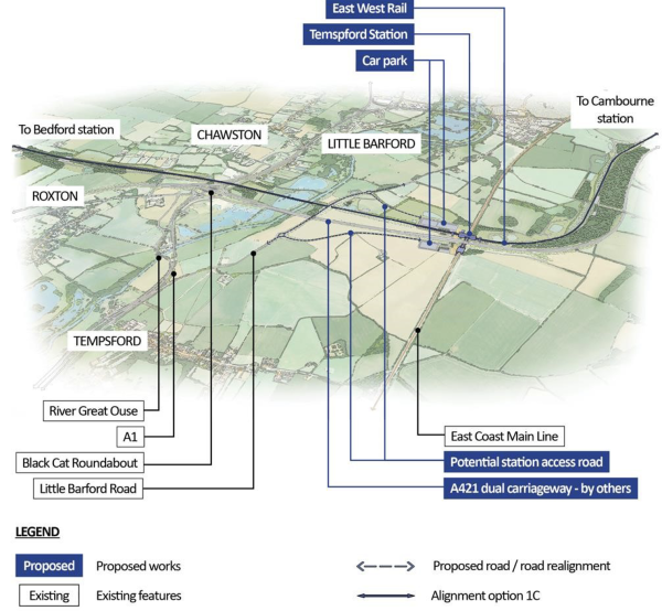
Figure 22: Aerial illustration of proposed Tempsford alignment
4.9.2 Acceleration of Tempsford station
How we’ve updated our design proposals
At our Route Update Announcement in 2023, we selected an alignment with a station at
Tempsford because of its potential to unlock the opportunity for new homes and development. Separate to this work, the independent New Towns Taskforce has now recommended Tempsford as a potential location for a new town and the government is commencing a Strategic Environmental Assessment on recommended locations, as well as any reasonable alternatives, before confirming which places will be taken forward as new towns and how they will be delivered.
The station at Tempsford is proposed to serve both EWR and the East Coast Main Line. In January 2025, the government announced its intention to deliver the East Coast Main Line part of the station ahead of the full delivery of the EWR station.
This would bring some of the benefits of the EWR project to the Tempsford area sooner, with a phased introduction of transport connections that would ultimately lead to a north-south-eastwest hub – improving connectivity for existing and new communities and developments on both sides of the East Coast Main Line and new A421 dual carriageway.
We’re working with Network Rail to accelerate the development of our design for the station. We’ve updated the design to allow a phased delivery of the station that would minimise disruption as later parts serving East West Rail are built, while making sure that passengers can easily switch between the two lines once both are finished.
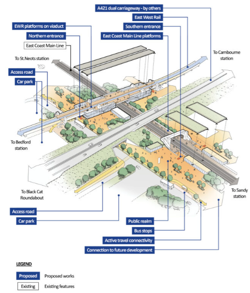
Figure 23: Illustration of proposed Tempsford station
4.9.3 East Coast Main Line rail logistics hub
What we presented at our 2024 non-statutory consultation
During our most recent consultation we proposed the potential use of a temporary rail-based logistics hub, to support construction of EWR. Its connection to the East Coast Main Line would allow materials such as ballast, sleepers, and rails to be delivered by rail and distributed along the route. We presented two potential locations for the rail logistics hub:
- Option B - would be located on land between the new railway and new A421 dual carriageway. Connection to the East Coast Main Line would be to the southbound slow line, directly to the south of the A428 overbridge. From there, the link would immediately turn away from the East Coast Main Line and cross eastwards towards the EWR route.
- Option F - would be located to the west of the East Coast Main Line, north of EWR Alignment 1c and south of Little Barford. Connection to the East Coast Main Line would be to the northbound slow line. The entry link from the East Coast Main Line would be to the north of the proposed East Coast Main Line station northbound platform and would immediately turn away from the East Coast Main Line, avoiding the need to run alongside it.
Due to its location north of the new A421 dual carriageway, Option F would only be compatible with Tempsford Alignment 1c. Option B would be compatible with both Tempsford Alignment 1b and 1c. For this reason, we did not choose a logistics hub location until a Tempsford alignment was confirmed.
What you told us
Several respondents supported the use of a rail logistics hub, recognising its potential to reduce lorry traffic, lower emissions, and enable the delivery of construction material by rail. Some suggested keeping the logistics hub as a permanent intermodal freight hub or road-rail interchange after construction for long term environmental and economic benefits. This included suggestions to explore the potential for permanent connections between the East Coast Main Line and EWR.
However, concerns were raised by a few respondents about the potential for increased flood risk and impacts on local watercourses during construction and operation of the hub. Some felt that with better planning, the need for a logistics hub could be avoided altogether. Others emphasised the importance of minimising disruption to the countryside and biodiversity, suggesting alternative locations which they felt would reduce environmental impacts.
There was support for Option B due to its compatibility with both Alignments 1b and 1c, whilst a few other respondents noted its potential to reduce construction-related road traffic. It was suggested that there was potential to use the hub earlier in the construction programme and that it would support track laying eastwards before the Tempsford viaduct is completed. A few respondents viewed Option B as aligning with the Bedford Borough Council Local Plan 2040, which allocates land at Little Barford for 4,000 homes, and as having less impact on future residential development.
A few concerns were raised about the potential impact of Option B on high-grade agricultural land, local wildlife, and nearby residential areas due to noise, traffic, and visual intrusion. Respondents told us that clear restoration plans and mitigation measures would be needed. Some noted that other infrastructure projects had already affected nearby land, and Option B could make this worse by impacting farm buildings and potentially sterilising land that is allocated for housing.
Option F was supported by a few respondents because it is close to existing infrastructure which they said could help reduce traffic impacts, particularly in Eynesbury, and require less mitigation. The greater distance from residential areas, which was felt would reduce noise and air quality impacts, was also highlighted. It was also felt that Option F could better serve both the East Coast Main Line and EWR routes.
However, concern was raised about the visual impact of Option F, the amount of land it would require and its proximity to the proposed Tempsford station and heritage assets. A few respondents also thought that Option F could have a negative impact on future residential developments and may potentially delay the delivery of a significant number of homes.
How we’ve updated our design proposals
As we've confirmed that Alignment 1c is the proposed alignment in Chapter 4.9.1, and explained the new plans to accelerate the delivery of a station serving the East Coast Main Line in Chapter 4.9.2, Option B is proposed as the location for the rail logistics hub.
The acceleration of East Coast Main Line elements of the proposed Tempsford station design introduces additional complexity in an active construction site. Further construction planning work has highlighted that Option F would require more utility diversions to be carried out before it could be constructed, which would cause significant delay to the completion of the railway. The location of Option B being further away from the proposed station and key utilities would avoid these issues and disruption to the phasing of the proposed new settlement at Little Barford.
We’ve refined the layout of Option B and how it links to the East Coast Main Line by rail, based on feedback from our most recent consultation, including discussions with local authorities. As a result we’ve moved the rail link approximately 130 metres south to reduce impacts on nearby properties. We’ve also relocated the entry road, which was previously proposed to be near the B1046 close to Potton Road, further south to use the bridge over the new A421 dual carriageway.
Regarding concerns about flood risk, Option B is not located within a flood zone and risk of flooding is limited to surface water associated with a drainage ditch close to Top Farm. Any realignment that we do will take into account the plans for the A428 scheme, which will also be realigning this drainage ditch. We’ll also continue to assess flood risk in the area.
Regarding heritage concerns, Option B is largely within land which has already undergone investigations for the A428 scheme and therefore buried archaeology is not expected to be found. In addition, there are no Listed Buildings nearby, and whilst those at Little Barford would have a partial view of Option B, which may affect their setting, this is further away and therefore would have less of an impact than Option F.
We're planning environmental mitigation such as grassland planting to preserve views of the landscape, and woodland planting to screen views from Little Barford. The hub is remote and would be partially screened by existing vegetation and woodland. The new A421 embankment would also partially screen views of the hub from the east. We understand that environmental impacts are an important consideration and we’ll continue to develop mitigation measures as we refine our plans for the rail logistics hub.
More details will be provided when we consult in 2026.
Design development in this route section
4.9.4 Alignment and gradient of the railway
In the Roxton area, we’re considering refining the alignment and gradient of the railway to address concerns about construction traffic in the local area, and potential impacts on the character of the local landscape. To do this we’re looking to reduce the height of the railway to the west of Roxton Road by up to 8 metres by moving the railway approximately 35 metres to the north. By lowering the vertical profile of the railway, we would also reduce its visual impact and help it better integrate into the surrounding landscape. We’re also considering reducing the depth of the cuttings south of B1046 St Neots Road by an average of 2 metres.
These changes would also be expected to reduce the number of HGV’s on local roads during the construction period by reducing the amount of material that would need to be moved or imported during construction. This would therefore help to minimise disruption for residents and businesses. It also would also support our commitment to reduce carbon emissions across the project.
More details will be provided when we consult in 2026.
4.9.5 How the railway would serve St Neots
In response to feedback about connecting EWR to the existing St Neots station, we still do not consider this to be feasible due to limited capacity on the East Coast Main Line for EWR trains. We set out further reasons why we consider this not to be feasible in our Consultation Feedback Report from 2023. In addition, by creating a new station at Tempsford rather than using the existing station, the potential to unlock growth in the area can be realised. This is because the new station would enable connections to future development areas south of the station.
Feedback also asked us to consider an additional EWR station east of St Neots on the current proposed alignment. Whilst our proposals do not preclude this being introduced in the future, this is not included as part of the current proposals for EWR as it would not be expected to bring sufficient benefits to make up for increased travel times and the construction disruption.
To support ease of access, we would promote active travel routes to the new station at Tempsford from the area of St Neots as part of its door-to-door connectivity plans to encourage walking and cycling from nearby communities. Car parking would also be provided.
More details will be provided when we consult in 2026.
4.9.6 Environmental mitigation
Much of the railway through this route section runs parallel to the A428 Black Cat to Caxton Gibbet improvement scheme (the ‘A428 scheme’), which would form part of the new A421 dual carriageway. Due to the significant interaction between the two projects, we’ve adapted our environmental mitigation proposals to complement those proposed by the A428 scheme.
We’re looking to enhance the local landscape and connections for wildlife by using planting to link fragmented woodlands, screening the railway to the south and defining the existing transport corridors. We’re assessing protected species, and the planting would also improve the east-west bat flight corridors that have already been identified as part of the A428 scheme including south of Boys Wood and at Hen Brook. This work aims to link up areas of ancient woodland and help to integrate the railway with the landscape, including the setting of the adjacent Ouse floodplain.
4.10 Croxton to Toft
This section of East West Rail runs between Croxton and Toft, which is approximately 19 kilometres (12 miles) long. It begins at the roundabout to the east of St Neots, running north of Cambourne and the new A421 dual carriageway currently being constructed by National Highways as part of the A428 scheme, before crossing under the A428 and ending at the B1046 between Toft and Comberton. This section includes the construction of a station north of Cambourne and a tunnel beneath the A428 and Bourn Airfield.
Within this chapter we provide updates on the following proposals:
- Cambourne station
- A428 Bourn Airfield crossing
We also provide design development updates on the following topics:
- Cambridge Road roundabout
- Alignment and gradient of the railway
- Environmental mitigation
An overview of the updates is shown in Figure 24.
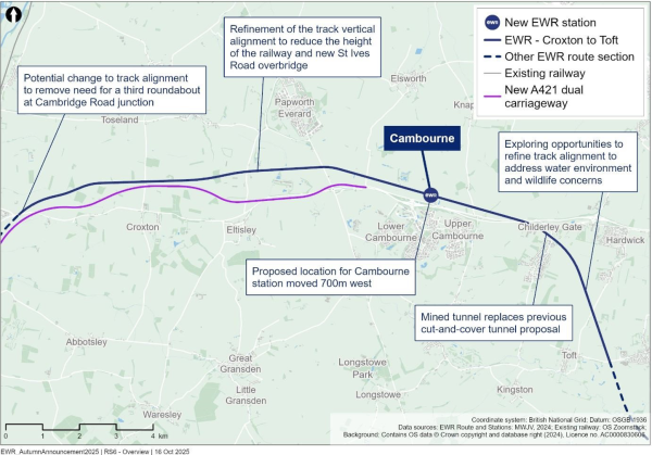
Figure 24: Map illustrating the Croxton to Toft route section
Proposal updates in this route section
4.10.1 Cambourne station
What we presented at our 2024 non-statutory consultation
We proposed building a new station at Cambourne to support existing communities and potential new growth in the area. We presented the location for this station, to the north of Cambourne, on the northern side of the A428 and St Neots Road. The plans showed a station building to the south of the proposed railway line with two platforms and a footbridge with stairs and lifts to provide step-free access.
We also showed how Cambourne station would include an active travel hub including cycling facilities, bus facilities and a car park. The plans showed that vehicles would access the station via St Neots Road and that pedestrian access to Cambourne would be via a new footbridge crossing over the A428 and St Neots Road.
What you told us
Several respondents expressed strong support for a new station at Cambourne, highlighting the station’s potential to greatly improve connectivity to destinations such as Cambridge and St Neots. The station was also seen as essential for supporting the local economy and offering sustainable transport options for residents and surrounding communities.
Feedback told us that respondents would like the station to be integrated with both existing and proposed transport networks including bus links and active travel routes. Where new routes may need to be provided, respondents said they should be safe, convenient and well lit.
Respondents said they thought that the station would reduce road congestion and suggested that a multi-storey car park should be built to prevent overflow parking in residential areas.
Whilst several respondents were supportive of a station in Cambourne, some questioned whether the specific location was the best, with concerns raised that it would be too far from the town centre and that the A428 would cut it off from the town. Suggestions included relocating the station further west (closer to the A428 roundabout junction) or to the south of the A428 to make it easier to access.
Regarding the station layout, several respondents said there should be accessible features including lifts, ramps, toilet and changing facilities and cycle storage. In addition, respondents said that it would be important to provide secure and affordable parking that included electric vehicle charging points.
How we’ve updated our design proposals
In response to the consultation feedback, we’ve reviewed the station location. By moving the station location from where we presented at the consultation to a location north-east of the A428/Cambourne Road double roundabout, it would be expected to:
- Enable a greater degree of growth and development of Cambourne due its location nearer to the centre of Cambourne and A428 road connections and fewer constraints from ancient woodland.
- Be more consistent with Local Plans, as it would avoid constructing on green space.
- Have a lower environmental impact than the current option, as it moves the station further away from Knapwell Wood.
- Be preferred by communities and stakeholders, based on the consultation feedback we’ve
We’ve therefore decided to move Cambourne station approximately 700 metres west to this location north-east of the Cambourne Road/A428 double roundabout.
More details will be provided when we consult in 2026.
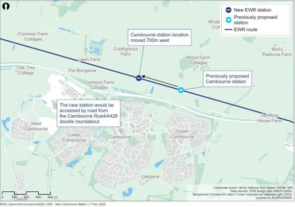
Figure 25: Map indicating the proposed location of Cambourne station
4.10.2 A428 Bourn Airfield crossing
What we presented at our 2024 non-statutory consultation
We proposed that the railway should run beneath the A428 and the Bourn Airfield site through a long cut and cover tunnel. The tunnel would be approximately 1.5 kilometres long (0.9 miles) and would pass beneath the A428, the north-east corner of the proposed Bourn Airfield development, the proposed Cambourne to Cambridge busway and active travel path, Wellington Way and Highfields Road.
We noted that a mined tunnel would have less of an impact on groundwater than a cut and cover tunnel. However, we explained that the cut and cover tunnel was the preferred option due to the higher cost associated with the mined tunnel because there would need to be deeper and wider approach cuttings either side of the mined tunnel than the cut and cover tunnel. There would also be the cost of disposing excavated material off site either side of the mined tunnel.
What you told us
Respondents expressed a range of views regarding the proposed long cut and cover tunnel. While the cut and cover method was supported by some respondents for being a lower cost solution, many respondents said they were opposed to it. Some respondents called for cost analysis that considered the full social and economic cost of the tunnel including its long-term benefits and opportunity costs.
Also, many respondents raised concerns about the potential impact of the proposed cut and cover method on the Bourn Airfield development. Several respondents thought that it would harm chalk aquifers and a few thought that it would increase surface water runoff. They thought that a mined tunnel would be a safer alternative, with less of a risk to watercourses and underground aquifers.
How we’ve updated our design proposals
We’re now proposing a mined tunnel in this area.
Taking account of feedback from our most recent consultation, we’ve undertaken further work on our method of construction and now expect to be able to reuse much of the excavated material from the mined tunnel and associated cuttings. This means there would be less cost and waste associated with this method than previously thought. Also, additional design work on the ventilation and emergency access for the cut and cover tunnel option has shown that this tunnel would need to be larger, which would increase costs and mean it would take longer to build.
We now expect the mined tunnel would be cheaper than the cut and cover tunnel and would also bring the following benefits compared to the cut and cover tunnel:
- It would avoid the need for local road disruptions and road diversions, including the A428, the proposed Cambourne to Cambridge Busway, and local roads.
- It would reduce impacts on the Bourn Airfield development compared to a cut and cover tunnel as the mined tunnel would cause significantly less disruption above ground within the development.
- It would reduce the risk of damage to trees in Waters Wood, north of All Angels Park in Highfields Caldecote.
- It would have fewer impacts on groundwater - including aquifer storage, water availability and aquifer recharge - because we wouldn't need to excavate as much material as with a cut and cover tunnel, given it wouldn't need to be as deep. It would reduce environmental impacts such as noise, visual changes and biodiversity loss, compared to a cut and cover tunnel.
We’re now working on more detailed designs for the mined tunnel, using new information from the ground investigation surveys that we carried out earlier this year. We'll also carry out an environmental assessment and develop mitigation proposals to reduce potential negative impacts.
More details will be provided when we consult in 2026.
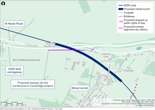
Figure 26: Map indicating the proposed location of the mined tunnel
Design development in this route section
4.10.3 Cambridge Road roundabout
In response to feedback from our recent consultation, at the new Cambridge Road junction currently under construction as part of the A428 scheme, we’re proposing to change the alignment of the railway to remove the need for a third roundabout to be built to the north of the junction. Instead, we would change the alignment of the road to provide enough space for the railway to fit beneath. This would then require us to move the location of the adjacent drainage ponds. We would also need to adjust our construction process to include a temporary road alignment, which wouldn't require the use of as much land.
More details will be provided when we consult in 2026.
4.10.4 Alignment and gradient of the railway
To address concerns about the visual impacts of the railway in this route section, we’re looking to reduce the height of the railway between West Brook and St Ives Road and move the farm accommodation track and public right of way diversion away from West Brook to a new overbridge 200 metres further east. The reduction in the height of the railway would also enable us to reduce the height of the St Ives Road overbridge. This would reduce the impact on nearby properties.
We’re also looking at how we can change the alignment in this route section to address concerns about the local water environment and associated wildlife. Between the A428 Bourn Airfield crossing and the B1046, we’re considering where we can change the alignment of the railway to introduce shallower gradients whilst also making sure we can cross over local watercourses and streams and accommodate local wildlife. We could do this by moving the alignment slightly west where it crosses Hardwick Road so that it crosses over a watercourse at a lower level. We’re also looking to increase the height of the railway at the point where it crosses the B1046. We would be able to do this without increasing the footprint of the overbridge by improving the design of the road and extending the 30 mph speed limit that is currently in place in Comberton village to reach this point.
More details will be provided when we consult in 2026.
4.10.5 Environmental mitigation
As this section of the railway will follow the route of the A428 scheme, we’re considering how our proposals for mitigating any environmental impacts will work alongside those that are already proposed as part of the A428.
We’ve carried out geophysical surveys in areas of potential archaeological interest. Based on the findings of these, we’ve changed the location of drainage ponds, stockpiles and compounds. This means we won't need to use as much land between St Ives and Ermine Street as previously thought.
We’ve developed our plans for green bridge crossings for Hardwick Road, Comberton Road and Hardwick Bridleway 5 in response to feedback from our recent consultation. We’re now planning to include mitigation earthworks and more planting to make sure wildlife can still travel between habitats across the railway. We’ve also added footpaths to make the bridges easier to use and to keep NMUs and motorised users separate to improve safety.
Our environmental surveys of priority habitats and protected species have shown us how wildlife moves around the area, so that we can manage our impacts appropriately.
4.11 Comberton to Shelford
This section of EWR runs between Comberton and Harston, where EWR would join the Shepreth Branch Royston Line, and improve the existing railway between Harston and Addenbrooke’s Road in Cambridge. This part of the route is approximately 14.3 kilometres (8.9 miles) long and includes the construction of Bourn Brook Viaduct, Chapel Hill tunnel and Hauxton junction.
Within this chapter we provide updates on the following proposals:
- Newton to Harston connectivity and Newton footbridge
We also provide design development updates on the following topics:
- Bourn Brook to Harlton Road
- Chapel Hill
- Hauxton junction
- Baggot’s Farm overbridge
- Hauxton level crossing
- Rectory Farm
- Ninewells and the DNA cycle path
- Environmental mitigation
An overview of the updates is shown in Figure 27.
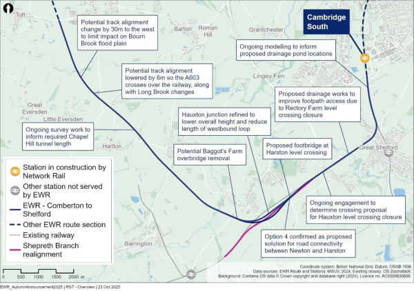
Figure 27: Map illustrating the Comberton to Shelford route section
Proposal updates in this route section
4.11.1 Newton to Harston connectivity and Newton footbridge
What we presented at our 2024 non-statutory consultation
We proposed that the Harston level crossing, the No.37 level crossing, Hayes level crossing and Rectory Farm level crossing would need to be closed to accommodate the new railway.
To avoid separating Newton and Harston when Harston level crossing is closed, we proposed two options:
- Option 1 - divert Newton Road to the south-west of the existing road, passing over the Shepreth Branch Royston Line via the relocated bridge, before heading west to join the realigned A10.
- Option 4 - provide a connection from Newton to Harston via London Road. North of the realigned railway, a new road connection would use the route of the current Shepreth Branch Royston Line track to connect to Station Road, south of Harston. This would include a route for pedestrians and cyclists.
We set out that our emerging preferred option for the road diversion was Option 4 because this option would:
- Require less complex infrastructure than Option 1 (as this would need a large bridge over the Shepreth Branch Royston Line).
- Require no new embankments and less removal of earth than Option 1 as it is predominately ‘at grade’ (ground level).
- Cost less and take less time to construct than Option 1.
- Have greater journey time reliability than Option 1, as it avoids delays at the junction with the A10 (when coming from Newton towards Harston), particularly at busy times. It also avoids a safety risk identified with the right turn onto the A10.
- Have less of an environmental impact than Option 1 in terms of impacts on landscape, visual, noise and vibration. We also wouldn't need to use as much agricultural land as would be necessary with Option 1.
We also consulted on providing a new accessible footbridge approximately 400 metres (437 yards) east of the existing Harston level crossing, which could be used by pedestrians and cyclists to cross the railway instead of the level crossing.
What you told us
We asked respondents to tell us their preference between the two options that we presented for Newton to Harston connectivity, as well as giving the choice to respond with ‘Other’ or ‘No preference’. We also provided respondents with the opportunity to provide comments on this proposal. The feedback we received is summarised below.
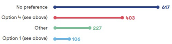
Figure 28: Numerical breakdown of responses to question 17a
A total of 1,353 respondents shared a range of views on maintaining connectivity between Harston and Newton. Of these respondents, 45% expressed no preference, whilst 30% were in favour of providing a connection via London Road (Option 4). A smaller percentage of respondents, 8%, opted for diverting Newton Road to the south-west (Option 1), whilst 17% of respondents indicated ‘Other’.
Concerns from respondents focused on the severance of the direct road link as well as the impact on access to schools, healthcare, shops, and the recycling centre in Thriplow. Increased journey times and congestion on the A10 were also highlighted.
A small number of respondents supported Option 1 for its potential to reduce traffic through Harston High Street and the potential for making access for farms and villages easier. However, concerns were raised by a small number of respondents about its potential impact on Harston’s character and the severance of properties.
Option 4 was strongly preferred over Option 1 for reasons including the potential to use existing infrastructure and the smaller amount of land that would be used compared to Option 1. Several respondents also supported Option 4 for having a lower environmental and landscape impact. Option 4 was perceived by many respondents to provide active travel benefits, including offering a safer route for pedestrians and cyclists, and a few respondents thought that it would help to maintain access to Harston’s facilities.
Option 4 was also seen as less disruptive to local residents and more cost-effective by a few respondents. However, concerns included increased traffic, noise, pollution, and the potential use of green belt land.
We asked respondents to tell us to what extent they would support an additional footbridge between Newton and Harston to maintain connectivity between these two communities. We also provided respondents with the opportunity to provide comments on this proposal. The feedback we received is summarised below.
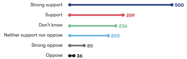
Figure 29: Numerical breakdown of responses to question 18a
A total of 1,329 respondents shared their views on this topic. Of these respondents, 58% expressed support for the proposed footbridge between Newton and Harston, with 38% strongly supporting and 20% supporting the proposal. In contrast, 9% opposed it, including 6% who strongly opposed. A further 33% were either unsure or neutral, selecting ‘Don’t know’ or ‘Neither support nor oppose’.
A large number of respondents supported the proposal to provide a new footbridge for pedestrians and cyclists, east of the existing Harston level crossing. They said this would be important for maintaining connectivity between Newton and Harston, enabling active travel, and providing access to local services such as schools, shops, and medical facilities.
Respondents emphasised the need for the bridge to be accessible for wheelchairs, mobility scooters and cyclists without requiring dismounting or navigating steps. It was also suggested that there should be adequate separation between pedestrians and cyclists on the bridge, and that slippery tactile paving and dangerous barriers should not be used.
Some were concerned that the location of the footbridge would increase the distance and travel time between Harston and Newton, with suggestions to place the bridge closer to the existing level crossing to minimise detours. Concerns were also raised about whether people would use the proposed footbridge, with some respondents questioning whether it would be value for money, or whether it is needed. Some respondents proposed alternative solutions, such as an underpass or a road bridge.
Others opposed the footbridge because they thought it would have a negative visual impact or that it wouldn’t be suitable for some users. Suggestions were made to improve the design and location of the bridge to better serve the community, including connecting it to existing paths and ensuring it is well landscaped.
How we’ve updated our design proposals
Taking account of consultation feedback, we’ve confirmed Option 4 will be used to maintain road connectivity between Newton and Harston when the level crossings are closed due to its reduced infrastructure and lower environmental impact. Compared to Option 1, Option 4 wouldn't require us to use as much agricultural land and would reduce the potential severance of agricultural land holdings. It would reduce impacts to the historic landscape and the views across the landscape from Harston and along Newton Road.
Option 4 would create a new link road between Station Road and London Road along the existing railway corridor, which would be realigned to make room for a new grade-separated junction.
On London Road, we’ve updated the design of the road to reduce the amount of infrastructure and earthworks required. The realigned road is now positioned to the west of the existing road so that an underpass to connect to Shelford Road is no longer needed, which would also mean that London Road could remain open to traffic during construction. It also means that we can significantly shorten the road realignment where it runs south along Cambridge Road.
A new overbridge over the railway on London Road would help reduce construction time and would include a foot/cycle way which is not currently present on the existing bridge. We’re discussing speed limits and junction arrangements for both London Road and the new link road with the Local Highway Authority.
Feedback from the consultation also supported a new footbridge proposal, which would allow pedestrians and cyclists to cross the railway at Newton. This has been incorporated into the design. We’re also considering how we can help improve active travel in the wider area, enabling more people to walk, wheel and cycle. For example, we propose that the new link road would include shared active travel routes, improving connections to Newton and areas to the east.
More details will be provided when we consult in 2026.
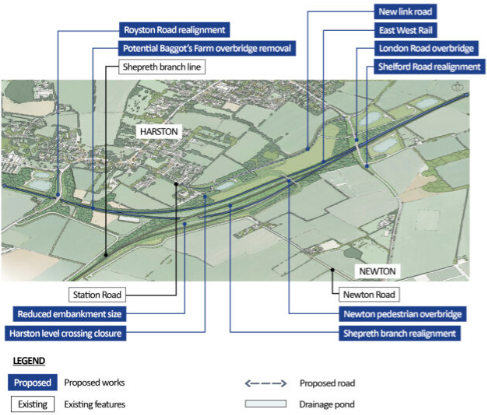
Figure 30: Aerial illustration of proposed Hauxton junction
Design development in this route section
4.11.2 Bourn Brook to Harlton Road
We’ve developed our design proposals in the Bourn Brook area following our most recent consultation.
Several respondents were concerned about the height and scale of the embankment between Bourn Brook and Harlton Road. In response, we’re looking to reduce the height of the railway at this location by 6 metres, meaning it would be approximately 2.5 metres above ground level. This would mean we could change the design of the A603 Cambridge Road crossing so that the railway would cross under the road instead of over it. This would reduce the footprint of the bridge structure and provide a flatter highway alignment reducing visual effects.
Several respondents also asked us to give more consideration to local wildlife and watercourses. We‘re now looking at diverting Long Brook to the east of the A603 Cambridge Road and then moving the point at which the railway crosses the brook 200 metres to the east. This will mean we can keep the height of the railway lower for longer. By realigning the brook we can introduce gentle curves, which would help it behave more like a natural stream and would better support local wildlife and natural water flow than the current straight and deep channel.
We’ve also reviewed the design for the viaduct that will cross Bourn Brook. To address concerns about the potential visual and ecological impacts of the proposed viaduct we plan to move the railway 30 metres to the west, which would mean that the railway would cross a narrower part of the floodplain. We could then reduce the size of the viaduct, which would reduce impacts on flood risk, and on habitats along the banks of the brook. We also plan to lower the height of the railway on the north side of the brook to reduce its visual impacts.
More details will be provided when we consult in 2026.
4.11.3 Chapel Hill
A number of respondents thought there should be further work around Chapel Hill to determine whether the tunnel could be extended to reduce visual and archaeological impacts and whether the way we would access the tunnel for maintenance could be amended to reduce its impacts on the surrounding area.
We’re carrying out a range of surveys including environmental, ground investigations and geophysical surveys to understand more about existing archaeological subsurface conditions including the presence of utilities and a bronze age barrow cemetery.
Once we’ve received data from these surveys, we’ll revisit the design of this tunnel to see if it would be beneficial to amend the alignment of the railway and length of the tunnel.
More details will be provided when we consult in 2026.
4.11.4 Hauxton junction
To address concerns about the visual impact of the new Hauxton junction, we're considering refining the design of the railway. We’re looking to reduce the highest point of the junction by approximately 2.7 metres, meaning this part of the rail line would now be approximately 7.5 metres above ground level rather than 10.2 metres. We’re also looking to move one of the two tracks at the highest point further south so that it integrates with the topography of the land, reducing its visual impact further. This would result in only one railway line being elevated over the ground-level tracks.
By reducing the height of the railway, we could also decrease both the width and height of the embankment. This would reduce environmental impacts in the local area as we now wouldn’t need to import as much construction material, which would mean that there would be fewer lorry movements on local roads.
Also we’re looking to shorten the ‘westbound passing loop’ that we proposed as part of Hauxton junction in our recent consultation from 4,000 metres to approximately 1,375 metres. It would only extend from the north of the A10 to the portal of Chapel Hill tunnel, rather than spanning the entire junction. This change would reduce the impact on New Farm Cottages and means that the railway would be further away from the nearby village of Harston.
More details will be provided when we consult in 2026.
4.11.5 Baggot’s Farm overbridge
Following feedback from relevant landowners and local stakeholders, we’re considering removing the Baggot’s Farm overbridge and associated access from our plans. We would do this to avoid the visual impact that the bridge would have. We’re talking to local landowners as we work on alternative plans for farm access in this area.
More details will be provided when we consult in 2026.
4.11.6 Hauxton level crossing
We previously confirmed that we’re proposing to close the level crossing on Hauxton Road and during our most recent consultation we asked respondents to tell us to what extent they support us providing an additional footbridge to the east of the Hauxton Road level crossing.
This is an ongoing complex area of investigation, with multiple variables and perspectives identified in the consultation feedback we received. This includes impact on landowners and people who live or work close to the railway line, both those in closest proximity to the level crossing as well as wider stakeholders, travel time assessments, accessibility requirements of users, space constraints either side of the level crossing, and environmental impacts.
Since the consultation, we’ve been engaging with the local parish council and people who live close to the railway in this location. We’re considering their feedback as we continue to work through options to identify the most appropriate solution.
More details will be provided when we consult in 2026.
4.11.7 Rectory Farm
Feedback from the last consultation showed that the permissive footpath near Rectory Farm level crossing is important to local people and is well-used. Respondents also said that the underpass frequently floods during the winter.
With the closure of Rectory Farm level crossing, we’re now proposing to undertake works to improve drainage conditions through the existing adjacent underpass which would also discourage potential trespass onto the railway.
More details will be provided when we consult in 2026.
4.11.8 Ninewells and the DNA cycle path
In response to concerns about flood risk we’re working on our drainage plans for the Ninewells area, including looking at other possible locations for the proposed drainage pond and how it interacts with the DNA cycle path. This work is being informed by regular meetings with the Greater Cambridge Partnership and the Sawston Greenway scheme.
We’re also still working through options for the replacement of the footbridge at Shepreth Junction, as part of our work looking at how EWR will encourage active travel.
More details will be provided when we consult in 2026.
4.11.9 Environmental mitigation
Our plans for environmental mitigation in this section of the route are being developed to make sure they take account of the potential realignment of Long Brook to provide wider habitat enhancement, and that they integrate with the setting of the Scheduled Monument Moated Site.
We’ve carried out work to understand which routes are used by protected species in the Bourn area, so that our plans include space under bridges at Bourn Brook, its tributary, and Long Brook for animals to continue to move through the area as they do now. This is also helping us improve our designs for the A603 Green Bridge, including adding earthworks and planting to keep habitats connected across the railway.
We’ve refined our plans for environmental mitigation to better integrate with the design changes around Hauxton junction and London Road overbridge. This includes using less agricultural land for mitigation near the London Road realignment.
We’ve reviewed our proposed locations for drainage ponds and we’re now including permanent flood compensation areas, with suitable environmental mitigation designed as part of these features. We’re considering relocating some drainage ponds and their associated mitigation, notably drainage ponds associated with the London Road realignment. This would reduce the likelihood of agricultural land being cut off.
Along the junction area towards Little Shelford, we’ll use earthworks banks planted with trees, hedgerows or shrubs to soften the views of cuttings and embankments from nearby homes and footpaths.
In the area between Great Shelford and Addenbrooke’s Road we’re working through options for mitigating the potential impacts of the additional track side infrastructure and construction compounds. We’re also thinking about how we can enhance the natural environment here, particularly along the Hobson’s Conduit, as well as how we can integrate our design with Network Rail’s Cambridge South Infrastructure Enhancements landscaped area to the south of Addenbrooke’s Road.
4.12 Cambridge
This section of EWR runs between Addenbrooke’s Road bridge which passes over the existing West Anglia Main Line, north of Great Shelford, to the A14 bridge north of Cambridge North station, to Yarrow Road in Cherry Hinton to the East of Cambridge on the Newmarket Line. It covers approximately 8 kilometres (5 miles) and includes improvements to Cambridge Station, a turnback at Cherry Hinton and a potential Cambridge East station.
Within this chapter we provide updates on the following proposals:
- Cambridge station.
- Cambridge East station.
We also provide design development updates on the following topics:
- Long Road overbridge.
- Environmental mitigation.
An overview of the updates is shown in Figure 32.
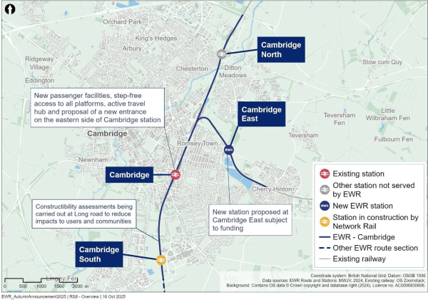
Figure 31: Map illustrating the Cambridge route section
Proposal updates in this route section
4.12.1 Cambridge station
What we presented at our 2024 non-statutory consultation
We proposed changes to Cambridge station that would improve capacity and accessibility, and accommodate the increase in train services and passenger numbers that EWR will bring. These improvements included extending existing platforms, building a new accessible platform 9, upgrading the station concourse, and adding new rail infrastructure. We explained how these changes would be made sensitively and in line with that station’s Grade II listed status.
We also explained how the turnback facility on the Newmarket Line would reduce the amount of time trains would have to remain at Cambridge station and therefore also reducing the need for us to provide new, additional infrastructure at the station, which is already very busy with no additional available space. In addition, the turnback facility would significantly reduce project costs and the duration of the construction period.
What you told us
There was support for our proposed changes to Cambridge station to increase capacity, improve accessibility, and enhance facilities at the station. Many respondents also highlighted the potential for an eastern entrance to connect the station with the Clifton Road area and other amenities.
How we’ve updated our design proposals
Taking account of consultation feedback, we’re now considering including a new eastern entrance to Cambridge station to the east of the existing station. This entrance would include:
- New passenger facilities, including a new ticket gate.
- Step-free access to all platforms.
- An active travel hub and direct links to active travel routes, such as cycle lanes and footpaths.
A new eastern entrance offers a once in a generation opportunity to deliver on a long-held aspiration for Cambridge. It would kick start the transformation of the Clifton Road area, significantly improving access to the eastern side of the tracks and the surrounding communities.
We’re in the process of identifying how the new entrance would join up with existing and new local transport services, and walking and cycling routes, including the proposed extension to the Chisholm Trail. We’re also working closely with local authorities, landowners and local stakeholders to ensure our proposals would align with the emerging policy and the revised Cambridge City Plan.
This updated proposal reflects our commitment to delivering a station that is not only fit for the future, but also responsive to the needs of the local community and fundamental to stimulating the wider economic growth of the city.
More details will be provided when we consult in 2026.
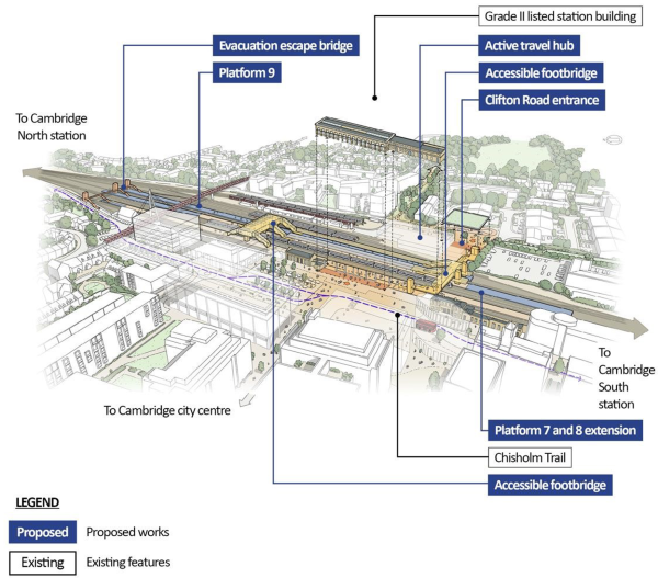
Figure 32: Aerial illustration of proposed Cambridge station works and surrounding area
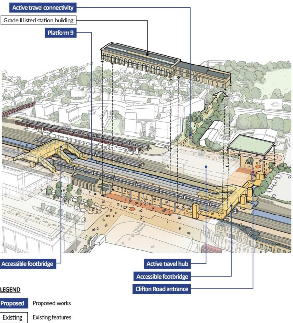
Figure 33: Aerial illustration of proposed Cambridge station works
4.12.2 Cambridge East station
What we presented at our 2024 non-statutory consultation
To avoid the need for trains to turn around at Cambridge station, where there is insufficient platform capacity to accommodate both existing train services and new EWR services, we proposed a turnback facility at Cherry Hinton.
While plans for a new station to the east of Cambridge on the line to Newmarket weren’t part of our proposals at our most recent consultation, we recognised the potential benefits it could bring including supporting local growth and creating new opportunities for communities in the east of Cambridge.
What you told us
Many respondents expressed strong interest in a new station to the east of Cambridge, identifying a range of potential benefits such as improved rail connectivity and reduced road congestion, relieving the pressure on Cambridge station and better access to public transport for residents in Cherry Hinton, Fulbourn and surrounding areas.
Several respondents were supportive of the station’s potential role in serving new or proposed housing developments and the redevelopment of Cambridge City Airport. Respondents thought a new station would have a positive impact on unlocking economic growth in east Cambridge and creating job opportunities at major employment hubs such as the Arm campus and Peterhouse Technology Park.
Some respondents suggested that a new station should be connected to walking and cycling routes, like the Chisholm Trail.
How we’ve updated our design proposals
As a result of consultation feedback and discussions with potential funders, developers and key stakeholders, we’re now considering including a new Cambridge East station within our plans for EWR. The station would be near Cambridge City Airport, which is due to be decommissioned, in an area with strong potential for growth and development. We would need to secure funding from a third-party to be able to build the station.
The station would help stimulate economic growth in the area and would unlock a new connection to the wider region via a significantly upgraded Newmarket Line, with regional links to Felixstowe and Ipswich.
The twin-tracking of the Newmarket Line and associated infrastructure work that we proposed at our recent consultation as part of our plans for the turnback facility to the west of Cherry Hinton would be needed to build the new station. The turn-back facility would provide additional operational benefits over and above what the new station would offer and so we’ve kept this in our plans.
At this stage, the design of this station is still in its early, feasibility phase. We’re aware of challenges around the site and we’ll continue working with third-party funders to explore how this opportunity could be realised to support economic and housing growth in the area. If third-party funding is not secured the station will be removed from our plans.
More details will be provided when we consult in 2026.
Design development in this route section
4.12.3 Long Road overbridge
We’ve developed the proposals at Long Road in response to concerns raised about congestion and road journey times during its reconstruction. Long Road is part of the Cambridge A1134 ring road system and we understand that reconstructing the overbridge would likely have significant local traffic impacts. The existing structure has some elements that will need to be replaced very soon, such as the metal piers and deck, and therefore would likely need to be replaced regardless of the EWR proposals.
We’re taking concerns about congestion during reconstruction into consideration and carrying out further work to look at options for the bridge and our construction approach to try to reduce potential disruption. We’re still proposing to fully close Long Road and reconstruct the bridge on its current alignment.
Options include a full road closure on Long Road for a minimum of 6 to 13 weeks, using modern methods of construction such as off-site pre-fabrication to keep the closure time to a minimum. A temporary reconstruction of the bridge next to its current alignment was considered but ruled out due to a lack of space, potential environmental impacts and the longer overall construction programme.
Enabling works, including the diversion of existing utilities, would still be needed in the area prior to and following the installation of the new bridge structure.
We’ll develop a detailed plan to minimise the impact on the city of Cambridge, in consultation with local stakeholders, including regular continued engagement with emergency services and local hospitals.
The bridge for the guided busway would not be impacted by the new bridge over the railway at
Long Road, however as part of the construction works, the entrance to St Mary’s School and Homerton College playing fields would be upgraded, and a new entrance to Cantabs Rugby Club would be provided from Long Road.
More details will be provided when we consult in 2026.
4.12.4 Environmental mitigation
We’re continuing to work on our design to minimise environmental impacts in the Cambridge area.
We’ve looked again at the location of track side infrastructure to reduce impacts to community facilities in the Cambridge route section. This includes potentially relocating a railway communications compound from the sports fields and running track at St Mary’s School and Homerton College to an area next to their car parking facilities.
As part of the design options for Long Road, we’re looking at our plans for environmental mitigation around the proposed drainage pond so that it helps enhance ecology in this area and the pond blends into the existing open space.
In response to feedback asking us to minimise the environmental impact of the twin tracking at Coldham’s Common, we’ve added plans to screen the railway from users of the common and nearby residential areas by planting trees and creating earthworks. This mitigation extends along the track through to Cherry Hinton, screening the visual impact of the railway. As part of the Cambridge East Station proposals, mitigation has been included to reduce the impacts of the construction and operation of the station as well as to improve the experience of passengers using the railway.
5. Next steps
5.1 Ongoing design development
We’re continuing to develop our designs for East West Rail (EWR) in discussion with statutory stakeholders including local authorities, environmental bodies and utility companies as we carry out more environmental and engineering technical assessments and survey work.
This includes a range of topographical surveys, protected species and habitat surveys, ground investigations, public right of way surveys, geophysical surveys and archaeological trenching. We’ll use the results from these to inform our assessment work, which includes ground interpretative analysis, sound and noise assessments, alignment refinements and environmental mitigation updates.
We’re also continuing to use the feedback from our most recent consultation to refine our design proposals for the areas where we’ve not confirmed decisions within this report. A thematic summary of all of the consultation feedback is presented in the 2024 Consultation Feedback Summary Report, which can be found by visiting: eastwestrail.co.uk/you-said-we-did
5.2 Ongoing engagement
As the project progresses, we’ll continue to engage with technical, statutory and community stakeholders, as well as impacted landowners along the route, whose views are helping to inform our evolving proposals.
We want to continue creating opportunities for genuine dialogue. Regular engagement allows stakeholders to raise concerns, share local knowledge, and help shape decisions as the design progresses. This two-way approach means the project is informed by people who understand the area and its needs. Our engagement is tailored to each group:
- Local authorities - We hold regular meetings, forums, and design workshops to keep councils informed and involved in shaping plans for their communities.
- Landowners - One-to-one meetings and technical discussions provide a direct line for input and feedback to understand their circumstances and, where possible, reduce impacts on their land and property.
- Statutory undertakers and utility providers - We meet regularly to identify and resolve potential clashes with existing or planned infrastructure early in the process.
- Emergency services - Ongoing collaboration via one-to-one and group meetings, including Resilience Forums, means public safety remains a priority and emergency access is fully supported.
- Community representatives - Local Representative Groups give parish councils and other local voices a chance to feed into the design. We also run community events at key stages and share updates through newsletters.
- Seldom heard groups (SHG) – engaging with SHGs is a key EWR commitment and we will build on the engagement activities that were part of the last public consultation. We will collaborate with local authorities and community representatives to ensure that SHGs are effectively reached, engaged and their feedback included in proposals.
- Accessibility and inclusivity - our commitment to accessibility and inclusive design is being supported through engagement with two expert panels: the Accessibility Advisory Panel and the Network Rail Built Environment Accessibility Panel. Feedback from both panels is being incorporated into our ongoing design development helping to ensure that the diverse needs of all user groups are considered and addressed throughout the project.
- Business, industry and academia - One-to-one discussions, technical meetings, and participation in industry events help us bring specialist knowledge and wider economic perspectives into the design.
We’re keen to get further input from each of these groups on a number of areas of the project. We’ll be carrying out engagement to:
- Share updates on our proposals that have changed since the last consultation.
- Show how we’ve developed design options that were shared at our most recent consultation.
- Discuss other key areas that would benefit from further feedback.
We’re looking at ways to make engagement more accessible and conversations even more meaningful to gather valuable input on the evolving design of EWR.
5.3 Planning our next consultation and applying for development consent
Our 2024 consultation explained our plan to hold a statutory consultation in 2026 in line with the legal requirements of the Planning Act 2008. Since then, the government has introduced the Planning and Infrastructure Bill into Parliament which contains reforms intended to streamline and accelerate the planning process. If it becomes law, the Bill would remove the requirement for statutory consultation which applies to major projects which require development consent like EWR.
The Planning and Infrastructure Bill is still in the Parliamentary process, so there remains some uncertainty around what changes will be made and when they will take effect. We’re monitoring the proposed reforms and considering their implications for the project.
Even if the legal requirement to carry out statutory consultation is removed, we’ll still carry out some form of consultation next year. Consultation will present our proposals along the whole route of the project and will confirm our plans for those areas where we’re currently still developing our designs and decisions have not yet been taken. A full set of route plans will be presented, updated to include all design development since our previous consultation, together with an updated plan showing the draft order limit boundary for the project. If the changes in the Planning and Infrastructure Bill come into effect before then, consultation may not be required to follow some of the current statutory requirements.
Our future consultation is expected to take place in spring or summer 2026 and will provide an opportunity for local communities and other stakeholders to comment on our proposals before we finalise our application to the Secretary of State for a Development Consent Order (DCO) which would authorise us to construct the project.
6. Get in touch
We’re here to answer any questions you may have. To find out more about East West Rail (EWR), head to our website at eastwestrail.co.uk. For specific questions about EWR or to raise any concerns, you can reach our team through the following channels:
- [email protected]
- 0800 123 4567 (Monday to Friday, 9am to 5pm, excluding Bank Holidays)
- Freepost EAST WEST RAIL
- Follow us on Facebook
If you have a specific question about your land or property you can contact our dedicated Land and Property team:
- [email protected]
- 0330 838 7583 (Monday to Friday 9am to 5:30pm, except Bank Holidays)
- Freepost EAST WEST RAIL LAND
If you want to speak to us about the Need to Sell (NTS) Property Scheme, you can email us at [email protected]
If you want to speak to us about Statutory Blight, you can email us at [email protected]
7. Glossary and abbreviations
|
Term |
Description |
|
A428 Improvement Scheme |
A scheme developed by National Highways to upgrade the A428 between Black Cat roundabout east of Bedford and Caxton Gibbet roundabout west of Cambourne. |
|
Abutment |
A structure that supports a bridge span or arch. |
|
Accessibility Advisory Panel |
A group of individuals who provide feedback and insights on accessibility issues. The panel helps us make informed decisions that enhance accessibility for all users, particularly those with disabilities. |
|
Active travel |
Making journeys in physically active ways - such as walking, wheeling (using a wheelchair or mobility aid) or cycling. |
|
Ancient Woodland |
Any area of land that has been wooded continuously since at least 1600 AD. Ancient Woodland is regarded as irreplaceable habitat and is protected under the National Planning Policy Framework. Ancient Woodland is sub-classified as ancient semi-natural woodland and plantations on Ancient Woodland sites. |
|
Biodiversity Net Gain |
An approach to development that aims to create and improve natural habitats to ensure a development has a measurably positive impact (‘net gain’) on biodiversity, compared to what was there before development. |
|
Blight |
The term blight used in this document refers to generalised blight. Generalised blight is typically used to describe the actual or assumed depreciation in value of property which may be attributable to a proposed infrastructure scheme. |
|
Conservation area |
An area of notable architectural or historic interest or importance designated by the local authority in relation to which change is managed by the duties set out in the Planning (Listed Buildings and Conservation Areas) Act 1990. |
|
Construction compound |
A secure area from which site work is managed and resourced, including but not limited to temporary offices, workshop, parking and storage during the construction phase of the project. |
|
Construction phase |
The stage during which construction works for the project will take place. This includes commissioning, when trains and facilities are being tested, but prior to passenger services starting. |
|
Cut and cover tunnel |
A construction method where a shallow excavation is made, and the tunnel structure is built inside the trench. |
|
Cutting |
A passage that has been dug through high ground for a railway or road. The resulting form is either sloped earthworks down to the railway/road or some form of retaining measure. |
|
DCO application |
The application for a Development Consent Order (DCO) that will be submitted by the applicant to the Planning Inspectorate to be examined on behalf of the Secretary of State (SoS) for Transport. |
|
Discontinuous electrification |
A method of powering trains that combines overhead electricity lines and onboard batteries. Only partial sections of the track are equipped with overhead lines. |
|
Door-to-door connectivity |
Refers to the travel needs of people from the very start of their journey until they reach their destination. This often includes active travel methods. |
|
Drainage pond |
A constructed basin designed to collect and manage excess surface water runoff, typically from rainfall or urban development, releasing it slowly to prevent flooding. |
|
Earthworks |
General term for the excavation and placement of soil, rock and other material; or for existing cuttings and embankments. |
|
East Coast Main Line (ECML) |
Railway line running from London King’s Cross to Edinburgh through Sandy and St Neots. |
|
East West Rail (EWR) |
A proposed new rail link, which would connect communities between Oxford, Milton Keynes, Bedford and Cambridge. The works that will be subject to the DCO application are referred to as the project. |
|
East West Railway Company Limited (EWR Co) |
Company set up by the SoS for Transport to develop the project. |
|
EIA Scoping Report |
A report prepared by an applicant to provide the information required under the EIA Regulations when requesting an EIA Scoping Opinion from the SoS. |
|
Electrification |
The development of powering trains and locomotives using electricity. |
|
Environmental Impact Assessment (EIA) |
A legally required process aimed at evaluating the potential environmental impacts of the railway’s construction and operation. |
|
Environmental mitigation |
The process of applying measures to remedy, reduce and offset negative environmental impacts caused by human activities. |
|
Environmental Statement (ES) |
A document prepared in accordance with the EIA Regulations that includes the information that is reasonably required to assess the likely effects of a development and which the applicant can, having regard in particular to current knowledge and methods of assessment, reasonably be required to compile but that includes at least the information required in the EIA Regulations and which is prepared in accordance with the latest EIA Scoping Opinion adopted by the SoS (where relevant). |
|
Flight corridor |
A commonly used aerial pathway that bats follow during migration or daily movement. They are critical for conserving migratory species and minimising risks from human-made obstacles like buildings, wind turbines, and transport infrastructure. |
|
Floodplain |
An area of ground adjacent to a watercourse or other source of water, which is subject to flooding from that source, including areas of low-lying ground that are subject to flooding from rising groundwater. |
|
Flood zone |
A zone based on the annual probability of flooding from fluvial and tidal sources, as defined in the Flood Map for Planning. |
|
Footbridge |
A narrow structure that is solely used to carry pedestrians, cyclists or equestrian users over a road, river, railway or other obstacle. |
|
Geoenvironmental survey |
An investigation undertaken to assess whether contamination is present is soils or groundwater that could pose a risk to people, property or the environment, usually undertaken alongside the Geotechnical Survey. |
|
Geophysical survey |
An investigation involving the making and interpreting of measurements of physical properties of the earth to determine subsurface conditions. |
|
Geotechnical survey |
An investigation to determine the nature and engineering properties of the soil and other materials and to determine soil profiles and property assignments for the purpose of design and construction. |
|
Grade-separated junction |
A railway or highways junction where tracks cross at different levels, often using bridges or tunnels. |
|
Great Western Main Line |
A major railway route in England running westward from London Paddington to Bristol Temple Meads, serving key locations including Reading, Swindon, and Bath. |
|
Greater Cambridge Partnership (GCP) |
A local delivery body formed to implement the Greater Cambridge City Deal, a long-term investment programme aimed at transforming infrastructure, housing, and skills across the Greater Cambridge region. |
|
Green belt |
A designation for land used in land use planning, to retain areas of undeveloped land surrounding urban areas, aimed to keep this land permanently open or largely undeveloped. |
|
Green bridge |
An artificial structure over road or rail infrastructure which is either vegetated or provides some other wildlife function and which either maintains, restores or enhances ecological connectivity, allowing safe crossing for wildlife. |
|
Green space |
An area of land covered with vegetation such as parks, gardens, street trees, or natural habitats within urban or suburban environments. |
|
Ground investigations |
The physical investigation stage of the geotechnical and geoenvironmental survey of which geophysical surveys may be one element. Comprised of targeted investigations including both intrusive and non-intrusive techniques to prove ground conditions, determine soil/rock parameters, assess for the presence of contaminants in soil and/or groundwater and identify hazards associated with the ground conditions to inform a scheme or the project. |
|
Groundwater |
Groundwater is water that exists, and which can flow, underground in saturated zones, such as in pore space in soils and rocks, beneath the land surface. |
|
Heritage asset |
A building, monument, site, place, area or landscape identified as having a degree of significance meriting consideration in planning |
|
|
decisions, because of its heritage interest. Heritage assets (HA) include designated heritage assets and non-designated heritage assets. |
|
Highway |
Land over which the public has a right of passage, and is protected by law. Public footpaths and bridleways are known as “public rights of way". |
|
Highway authority |
An organisation responsible for the maintenance of a public highway. Different organisations are responsible for particular roads. The duties and responsibilities of the Highway Authority are regulated by the Highways Act 1980. National Highways are responsible for the Strategic Road Network (motorways and some ‘A’ roads) and the County Council or a Unitary Authority are usually responsible for the local road network. |
|
Historic environment |
All aspects of the environment resulting from the interaction between people and places through time, including all surviving physical remains of past human activity, whether visible, buried or submerged, and landscape and planted or managed flora. |
|
Infrastructure Maintenance Depot |
A depot at which staff and equipment involved in maintaining rail infrastructure are based and from which maintenance operations are coordinated. |
|
Interchange |
A station at which passengers may change between trains serving different routes and destinations. |
|
Interested parties |
A person or organisation that has registered to take part in a DCO Examination and may participate in the examination of the application e.g. submit representations and attend hearings, and receive formal notifications as the examination progresses. |
|
Intermodal freight hub |
A site that facilitates the transfer of goods between different modes of transportation, such as rail, road, air and sea. |
|
Irreplaceable habitat |
Habitats which would be technically very difficult (or take a very significant period of time) to restore, recreate or replace once destroyed, taking into account their age, uniqueness, species diversity or rarity. |
|
Landscape character |
The distinct, recognisable and consistent pattern of natural and human elements that make one landscape different from another and give each area its unique sense of place. |
|
Level crossing |
A location at which vehicles and pedestrians may cross railway tracks at grade (at ground level). This definition includes accommodation crossings which provide access to specific properties; and crossings which are operated by their users rather than automatically. |
|
Light Maintenance Depot |
A facility where trains are maintained, including for servicing, inspection and cleaning. |
|
Listed building |
A building placed on a statutory list, because of its special architectural or historical interest, in relation to which change is managed by law. Listing includes the interior, exterior and the setting of the building. |
|
Local Highway Authority (LHA) |
The government organisation responsible for maintaining public roads in it’s area, typically a County Council. |
|
Local Planning Authority (LPA) |
The local authority or council that is empowered by law to exercise statutory town planning functions for a particular area of the UK. |
|
Local Representative Group |
These groups have been established by EWR Co along the route and include councillors, parish and town councils, and representatives from EWR Co. They offer an open forum for discussions – a place to share information and informative content on key parts of the development process, ask questions and discuss local opportunities or emerging concerns. |
|
Main river |
A statutory type of watercourse in England. They are designated by the Environment Agency under the Water Resources Act (1991) and are marked on a Main River Map. The Environment Agency’s powers to carry out flood defence works applies to main rivers but not to ordinary watercourses, which are the responsibility of Local Planning Authorities. |
|
Marston Vale Line (MVL) |
The existing line and services operating between Bletchley and Bedford. |
|
Marston Valley development |
A mixed-use project in Central Bedfordshire designed to deliver up to 5,000 new homes, extensive green spaces, and transport improvements over the next 20 years. |
|
Maintenance |
The combination of all technical and administrative actions, including supervisory actions, intended to retain a product in, or restore it to, a state in which it can perform a required function. |
|
Midland Main Line |
The main railway route between London St Pancras, Nottingham and Sheffield. |
|
Mined tunnel |
A tunnel excavated without removing the overlying rock or soil and open to the surface only at one or both ends during construction. |
|
Mitigation |
The proposed means to avoid, prevent or reduce the likely severity of potentially adverse effects. Mitigation is deemed effective if it renders a potentially significant adverse environmental effect non-significant. |
|
National Highways |
The government body responsible for managing the Strategic Road Network in England. Formerly Highways England. |
|
National Infrastructure Commission (NIC) |
Executive agency responsible for providing the government with impartial, expert advice on major long term infrastructure challenges facing the UK. |
|
National Planning Policy Framework (NPPF) |
The document that sets out government's planning policies for England and how these are expected to be applied. The NPPF was last revised in December 2023. |
|
Need to Sell Property Scheme |
A scheme available to eligible property owners who have a compelling need to sell but have been unable to do so other than at a substantially reduced value because of the EWR project. |
|
Network Rail |
Network Rail Infrastructure Limited, the organisation which owns the majority of the railway infrastructure in England. An arms-length body of the Department for Transport. |
|
Net zero |
Net zero refers to achieving a balance between the amount of greenhouse gas emissions produced and the amount removed from the atmosphere. |
|
|
Noise barrier |
Exterior structure designed to protect sensitive receptors from noise pollution. |
|
|
Non-motorised user |
Any individual who uses non-motorised modes of transport, including pedestrians, cyclists, and equestrians. |
|
|
Non-statutory consultation |
A voluntary engagement process undertaken by project promoters before submitting a planning application, particularly for Nationally Significant Infrastructure Projects (NSIPs). |
|
|
Operational phase |
The stage that occurs after the project is handed over by the relevant construction contractors and approved for operation. It will remain in its operational phase until it is decommissioned. |
|
|
Order limits |
The Order limits show the extent of land which is the subject of the DCO application. It shows the outermost extent of the land which the DCO application will apply to, and over which we will seek powers in the DCO application to acquire and/or use this land for the purposes of constructing and operating the project (both permanently and temporarily). The Order limits will be shown on plans submitted with the DCO application. |
|
|
Ordinary watercourse |
Any river, stream, ditch, drain, cut, dyke, sluice, sewer (other than a public sewer) and passage through which water flows that does not form part of a Main River. The Lead Local Flood Authority (LLFA) or Internal Drainage Board (IDB) where relevant, has powers for ordinary watercourses that are similar to those held by the Environment Agency for main rivers. |
|
|
Overbridge |
A structure, typically formed of a single span (or up to four), used to carry road, rail, or river traffic over the railway. |
|
|
Overhead line electrification |
The use of electrical cables suspended above rail tracks to transmit electrical energy to power trains. |
|
|
Oxford-Cambridge Growth Corridor |
A region defined by the government and the National Infrastructure Commission covering local authorities across the counties of Northamptonshire, Cambridgeshire, Hertfordshire, Buckinghamshire and Oxfordshire and the unitary authorities of Bedford, Central Bedfordshire, Luton, Swindon and Milton Keynes. |
|
|
Passing loop |
A passing loop is an additional section of track laid parallel to the main line which allows faster trains to overtake slower trains. |
|
|
Planning Act 2008 (PA 2008) |
The UK law that introduced a streamlined process for authorising Nationally Significant Infrastructure Projects (NSIPs) through a single consent known as a Development Consent Order (DCO). |
|
|
Planning Inspectorate (PINS) |
The government agency responsible for administering applications for development consent under the Planning Act 2008 (as amended) (PA 2008) on behalf of the relevant Secretary of State (SoS). |
|
|
Priority habitat |
Priority habitats are semi-natural habitat types identified as being most threatened and in need of conservation under the UK Biodiversity Action Plan (UK BAP). |
|
|
Protected species |
Protected species are animals or plants that are safeguarded by law due to their rarity, ecological importance, or vulnerability to harm. |
|
|
Railway corridor |
The physical space required for the safe operation, maintenance, and development of rail services. |
|
|
Risk |
The likelihood of an impact occurring, combined with the effect or consequence(s) of the impact on a receptor if it does occur. |
|
|
Risk assessment |
A systematic process of evaluating the potential risks that may be involved in a projected activity or undertaking. |
|
|
Route alignment |
The preferred Route Alignment which the railway follows between Oxford and Cambridge. |
|
|
Safeguarding directions |
Provisions that ensure that land which has been earmarked for major infrastructure projects is protected from conflicting developments before construction starts. |
|
|
Safety risk |
The risk of unsafe practices or situations occurring on the railway that may lead to accidents. |
|
|
Sawston Greenway scheme |
An active travel infrastructure project led by the Greater Cambridge Partnership (GCP). It aims to create a safer, more accessible route for walking, cycling, and wheeling between Sawston, Stapleford, Great Shelford, and key destinations in Cambridge. |
|
|
Scheduled Monument |
A historic building or site considered to be of national importance, placed on a list kept by the government and requiring government approvals for any works which might affect the Scheduled Monument. |
|
|
Shepreth Branch Royston Line |
The line that connects Cambridge to Hitchin via Shepreth. |
|
|
Siding |
A short track at the side of and opening on to a railway line. They are usually used for stabling trains. |
|
|
Strategic road network |
The network of motorways and major ‘trunk’ A-roads managed in England managed by Highways England (HE). |
|
|
Sub-national transport bodies |
Ad-hoc organisations that provide strategic transport governance on a larger scale than existing local transport authorities by grouping councils together. |
|
|
Surface water |
Water that is above the ground surface that is typically sourced from rainfall (see also pluvial), as opposed to groundwater. Can also be used to refer to small watercourses. |
|
|
Stakeholder |
Any person or organisation with an interest in the project and can either affect, or be affected by, the policies, objectives and outcome. |
|
|
Statutory blight |
The term used to describe a situation where a property is blighted in a legal sense, such as where it is in a development plan or within land safeguarded for a specific purpose, for example the railway, or included within a DCO for compulsory acquisition. |
|
|
Sustainability |
The commitment to designing, building, and operating the railway in a way that meets current transport needs while protecting and enhancing the environment, supporting communities, and enabling long-term economic growth. This includes reducing carbon emissions, promoting biodiversity, minimising disruption, and aligning with national and local climate goals. |
|
|
Thameslink |
Train operator running services between the south coast of England, Bedford, and Cambridge. |
||
|
Topography |
The arrangement of the natural and artificial physical features of an area. It includes the shape, elevation, and features of the land surface, such as mountains, valleys, plains, and bodies of water. |
||
|
Traction power compound |
An electrical network designed to deliver power to trains in a safe and efficient way. |
||
|
Train Maintenance Depot |
A complex of siding, buildings, platforms etc. where transhipment, stabling, servicing, repairs and other such activities are undertaken. |
||
|
Train service pattern |
The specifications and requirements that govern the operation of train services. This includes details such as the minimum number of services per hour, service intervals and the type of services that must be provided. |
||
|
Train service specification |
The minimum requirements for railway passenger services, including the number of stops, service intervals and capacity. |
||
|
Transport Assessment |
A comprehensive study that evaluates how the new railway will affect the surrounding transport network. |
||
|
Up-fast platform |
A platform that serves a faster running train service. These platforms are designed to allow high-speed services to stop at a station that they would otherwise pass through, improving connectivity and accessibility for passengers. |
||
|
Utility company |
A company that owns equipment which carries and distributes water, electricity, gas or telecommunications. These commodities are collectively known as ‘utilities’. |
||
|
Viaduct |
A long structure which is used to carry railway or highway traffic above the general level of the ground. It is typically formed of a series of five or more spans on piers. |
||
|
West Anglia Main Line (WAML) |
The railway route between London Liverpool Street and Cambridge. |
||
|
West Coast Main Line (WCML)
Abbreviations |
The railway route between London Euston and Glasgow. |
||
|
Abbreviation |
Description |
||
|
DCO |
Development Consent Order |
||
|
EIA |
Environmental Impact Assessment |
||
|
EWR Co |
East West Rail Company |
||
|
EWR |
East West Rail |
||
|
FP |
Foot Path |
||
|
HGV |
Heavy Goods Vehicle |
||
|
LHA |
Local Highway Authority |
||
|
LPA |
Local Planning Authority |
||
|
MVL |
Marston Vale Line |
||
|
NMU |
Non-motorised User |
||
|
|
NTS |
Need to Sell |
|
|
|
RSPB |
Royal Society for the Protection of Birds |
|