1. Welcome
New railways, roads and buildings are designed to improve people’s everyday lives. Our aim must always be to drive positive change and create more opportunities for people to live their lives to the full.
That purpose and principle is something I’m resolutely passionate about – and it’s at the heart of our mission for East West Rail. More job opportunities. Easier and quicker ways to get to work. New places where people can afford to take root and build a family. All of these and more are possible through the new railway line connecting Oxford, Milton Keynes, Bedford and Cambridge, an area bursting with potential and unique opportunities.
But with enormous benefits come important considerations. In all walks of life, good things for most can also have negative consequences for some. That inescapable truth is something we recognise and are determined to manage by ensuring we deliver the benefits and progress that local authorities and businesses have been calling for since the 1990s, whilst supporting those who may be materially affected by changes. We must find the right solutions that strike this balance while maximising the benefits that East West Rail will bring.
That’s why your views are so important to us. I’m passionate about collaboration and working hand-in-hand with you – our local communities and businesses – and actively encourage you to review and provide genuine, honest feedback on our latest proposals that are set out in this Consultation Document.
The proposals include updates on issues we know local communities are passionate about. This includes route-wide matters – such as overhead line electrification to power the trains and compensation for landowners affected by proposals – and updated infrastructure proposals at a local level, which we have presented in eight sections.
Your feedback on these updated proposals is really important to us. We have already made important changes to the design following public feedback, such as improving designs to remove or reduce the heights of embankments or viaducts.
By its very nature, the railway will underpin so many good things happening in the region – and we all have a stake in it. That’s why we would like to hear from as many of you as possible. We look forward to receiving your feedback and encourage you to attend the consultation events we are holding across the route, where you can ask questions about our plans as we start out on the next chapter of East West Rail.

David Hughes
Chief Executive Officer, East West Railway Company
1.1 About East West Railway Company
The Department for Transport created the East West Railway Company (EWR Co) in 2017 to develop plans for a new railway between Oxford and Cambridge. EWR Co is responsible for developing, designing and delivering the new railway.
2. Introduction
This document describes our infrastructure proposals for East West Rail – the new rail link that would connect communities between Oxford, Milton Keynes, Bedford and Cambridge. Our proposals involve the construction of a new railway between Bedford and Cambridge, plus essential railway improvement works to upgrade the existing railway between Oxford and Bedford.
The purpose of this non-statutory consultation is to obtain feedback on the early designs, including areas where we are considering options. We will take this feedback into account as we develop the designs in more detail and select preferred options. Your feedback will also be used to review potential opportunities and inform plans to mitigate the impacts of the project.
This consultation will run for 10 weeks from 14 November 2024 to 24 January 2025.
This document provides an overview of:
- The background to the project and the consultation process.
- Our infrastructure proposals for each section of the route.
- The operation of the railway.
- How we will manage impacts on the surrounding area.
The information in this document is supported by other consultation material including a Technical Report which provides further information about how we have developed our designs. We have also prepared an Environmental Update Report and a Transport Update Report, which contain preliminary information about the likely effects of our proposals.
We have also produced maps, plans and visualisations showing the proposed route alignment and features, the land that would be required for the project, and illustrations of what some of the main features of the railway could look like.
We are asking for feedback on the latest proposals from local communities and people who live and work in the area. We are also inviting comments from local authorities, other relevant organisations, and people whose homes or properties could be affected by the proposals. We encourage you to respond to the consultation and we look forward to receiving your comments. Please use the feedback form which contains questions about our proposals. Please make sure you share your feedback with us before the closing date of 24 January 2025.
We will take account of the feedback from this consultation as we continue to develop our proposals for the new rail link and carry forward our further design work and technical assessments. A statutory consultation will then be carried out in which we will present more detailed information about the proposed infrastructure, its likely environmental impacts and the measures and strategies we are developing to mitigate those impacts. Feedback from the statutory consultation will be taken into account before we finalise our proposals and apply for development consent to build the project.
3. Structure of this document
This document is structured as follows:
An introduction to East West Rail and to the project – Chapter 4
- The benefits of East West Rail.
- The stages of East West Rail.
- The journey so far.
- Our consultation process.
Operating the railway – Chapter 5
- Train services.
- Powering the trains.
- Supplying power to East West Rail.
- Stabling trains and maintaining the railway.
- Passing loops.
- Level crossings.
- Our approach to freight.
Delivering the railway – Chapter 6
- Environment and sustainability.
- Effects on traffic and transport.
- Public rights of way, highways and private access.
- Homes, land and property.
As introduced in Chapter 7, we have split our route into eight route sections. The following chapters describe the infrastructure proposals we are consulting on in each of the route sections.
- Oxford to Bletchley – Chapter 8
- Fenny Stratford to Kempston – Chapter 9
- Bedford – Chapter 10
- Clapham Green to Colesden – Chapters 11 and 12
- Roxton to east of St Neots – Chapter 13
- Croxton to Toft – Chapter 14
- Comberton to Shelford – Chapter 15
- Cambridge – Chapter 16
Chapters 17-19 set out the next steps for the design, how you can get involed, where to see more information on our proposals as well as details of the events that we will be holding. These events will provide you with opportunities to meet members of the team, share your comments and ask any questions that you may have. The document finishes with chapters 20 and 21: all the documents available in this consultation and the glossary.
There are also multiple ways that you can provide feedback, including:
- Completing the consultation feedback form online at eastwestrail.co.uk/feedback
- Emailing a copy of the feedback form to [email protected]
- Sending a copy of the feedback form to Freepost EAST WEST RAIL.
- Handing in a copy of the feedback form at a consultation event.
We want everyone to be able to take part in this consultation. It is important that everyone living in the communities East West Rail would serve gets the opportunity to share feedback. That's why key materials will be made available in accessible formats. If you or anyone else would prefer consultation material in a different format or language, please let us know by emailing [email protected] or calling us on 0330 134 0067.
Comments and feedback to the consultation will be carefully considered to help inform the continued development of the design, which we will present at our statutory consultation.
Please make sure you share your feedback with us before the closing date of Friday 24 January 2025.
4. An introduction to East West Rail and the project
4.1 The benefits of East West Rail
East West Rail is a once in a generation opportunity to create a new rail link which would connect people and businesses in the communities between Oxford, Milton Keynes, Bedford and Cambridge. By making it easier, faster and more affordable to get around the region, the new railway will open up new journeys, cut travel times on public transport, ease congestion on local roads and bring more jobs within reach of people living locally.
The vibrant communities between Oxford, Milton Keynes, Bedford and Cambridge blend beautiful landscapes and a rich cultural heritage with globally renowned centres of education, life sciences, technology and an increasingly dynamic business scene.
While it’s a fantastic place to live and work, the lack of good east-west transport links limits the ability for local residents to enjoy everything the area has to offer. From easier commutes to days out with friends and family, East West Rail would make it easier to reach the things that matter to you most, bringing a range of benefits to local communities and the UK more broadly.
The strategic objectives for East West Rail are to:
- Improve east-west public transport connectivity by providing rail links between key urban areas across the Oxford to Cambridge region.
- Stimulate economic growth, housing and employment through the provision of new, reliable and attractive inter-urban passenger train services in the Oxford to Cambridge region.
- Contribute to improved journey times and inter-regional passenger connectivity by connecting with north-south routes and routes beyond Oxford and Cambridge.
- Provide a sustainable and value for money public transport solution to support economic growth in the area.
- Meet initial forecast passenger demand and consider and plan for future passenger demand, making provision where it is affordable.
- Maintain current capacity for rail freight and make appropriate provision for anticipated future growth.
East West Rail will also be required to meet a range of more specific requirements which have been set by the Department for Transport to align with these strategic objectives.
Easier access to other parts of the UK
East West Rail would connect to most of the UK’s north-south main lines making it easier to get to the rest of the UK, opening up new journeys for local communities. Friends, family and days out would all be within easy reach, as would overseas destinations through better connections to international airports at Luton and Stansted.
Fast, easy travel across the region for everyone
East-west public transport is currently limited to a coach service, which takes 1 hour 50 minutes between Oxford and Milton Keynes at peak times, and the bus journey between Bedford to Cambridge, which takes up to 1 hour 30 minutes. With East West Rail, these journey times could be cut to under 45 minutes from Oxford to Milton Keynes and could take 35 minutes between Bedford and Cambridge.
East West Rail could take you from Oxford to Cambridge via Bedford, Bicester and Bletchley in approximately 1 hour 35 minutes, with no need to change in London.
Figure 1: Oxford to Cambridge approximate journey times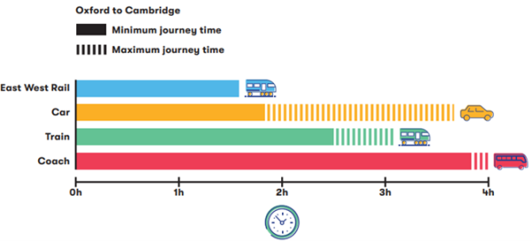
Bring more jobs within reach of local people
East West Rail would bring more people within commuting distance of high-quality jobs in the region, making it easier to get to employment centres whilst also boosting jobs in local areas.
Reliable public transport that will reduce congestion on local roads
Despite being a short distance apart, journeys from towns such as Milton Keynes and Bedford to Oxford and Cambridge can take a long time because of congested roads and the lack of public transport. By offering rail travel as an alternative, East West Rail would help to ease traffic on local roads and provide a reliable, fast and more sustainable public transport option for people. The railway also creates the potential to reduce the number of lorries going through the area’s towns and villages.
A greener way to travel around the region
East West Rail aims to be a net zero passenger railway. The railway would reduce local people’s reliance on private cars and would lead to cleaner air and fewer emissions. Compared to a car journey, travelling by train can reduce emissions by up to two thirds.
Opening up new areas for businesses to grow
Growth in Oxford and Cambridge is constrained. Connecting them with the fast-growing and high potential towns and cities in between, like Milton Keynes and Bedford, would make places more appealing for people wanting to start and grow all types of businesses.
Expanding the labour market locally
The railway would help attract and retain the best talent in the region. It currently takes nearly an hour to travel just 9 miles from Cambourne to Cambridge in the morning rush-hour, but East West Rail could reduce this to 15 minutes. Bedford and Cambridge would be just 35 minutes apart, so East West Rail could expand the number of people within commuting distance of high-quality jobs in the region, giving the region’s businesses and innovators access to a much bigger pool of people to hire from as they grow.
Attracting businesses into the region and investment into the country
Just as East West Rail will bring people closer to jobs, it would also bring businesses closer to their supply chains, research sectors, competitors and other sectors. This provides a unique opportunity in the region and the UK for businesses to develop in dynamic ecosystems and clusters. Such vibrant business ecosystems already exist in pockets, such as the Cambridge Biomedical Campus and the Oxford Science Park. East West Rail would make it possible at scale, which would attract more businesses into the region and investment into the country by offering unrivalled collaboration and innovation opportunities, which will lead to fresh ideas, higher productivity and new spin outs.
4.2 The stages of East West Rail
East West Rail is being promoted and brought into use in three connection stages.
Connection Stage 1 enables services to run between Oxford and Milton Keynes. The first part of this stage, the link between Oxford and Bicester, is already in place. The work to extend services further north and east to Bletchley and Milton Keynes was given planning consent in 2020 by an order made by the Secretary of State under the Transport and Works Act 1992. Construction is well underway and passenger services will start running from 2025.
Connection Stage 2 work is ongoing to bring forward services between Oxford and Bedford from 2030. Planning consent for these works was also granted by the Transport and Works Act order in 2020.
Connection Stage 3 would complete East West Rail and enable passenger services to operate between Oxford and Cambridge via Bletchley and Bedford. To complete this work, we will need to apply for a Development Consent Order (DCO), which would grant consent to build the new railway between Bedford and Cambridge, as well as the other upgrades between Oxford and Bedford to deliver the full proposed East West Rail service.
Connectivity to Aylesbury remains a longer-term aspiration, but is not currently within the scope of East West Rail and is not included in the proposals set out in this public consultation.
More information about the DCO process can be found in section 4.4.1 of this chapter.
4.2.1 Accelerating Connection Stage 2
The works being brought forward are:
- Works to nine level crossings on the Marston Vale Line. These are to be delivered alongside Network Rail works to replace Marston Road and Manor Road (Kempston Hardwick) level crossings with road bridges. All these works were authorised by a Transport and Works Act order made by the Secretary of State in 2020.
- Track renewals and supporting works along the Marston Vale Line which would be disruptive to the new service if delivered later, as well as minor safety and accessibility improvements at stations.
With the release of this accelerated funding, we are now progressing the infrastructure design work to the next level of detail to confirm the scope and construction timeline, as well as where the new service will call.
Whilst these works will bring forward an initial new train service between Oxford and Bedford, there is further work in that area that will be needed to enable the full operation of trains between Oxford and Cambridge for Connection Stage 3. These further works are described in the Fenny Stratford to Kempston route section chapter.
4.2.2 The project we are consulting on
To deliver Connection Stage 3, we propose to build a new railway between Bedford and Cambridge. We also propose to upgrade and refurbish the existing railway infrastructure between Oxford and Bedford to enable East West Rail passenger services to operate along the whole route between Oxford and Cambridge.
The proposed new railway between Bedford and Cambridge and the associated work to upgrade the existing railway between Oxford and Bedford are referred to as ‘the project’ and are the subject of this non-statutory consultation.
The project includes the following:
- Construction of a new railway between Bedford and Cambridge, including the construction of new stations at Tempsford and Cambourne.
- Improvements to the existing railway between Oxford and Bedford and the approach into Cambridge.
- Works to upgrade existing stations along the route to ensure they can accommodate increased passenger numbers, including:
- Remodelling Bedford station.
- The potential consolidation or upgrade of stations on the Marston Vale Line.
- Relocating Bedford St Johns station.
- Works at Cambridge station.
- Building new infrastructure and upgrading existing structures, including viaducts, tunnels, bridges, cuttings and embankments.
- Improvements to or closure of level crossings and the provision of suitable replacement crossings.
- Works to enable the full or discontinuous electrification of the railway including the installation of overhead lines, substations and grid connections.
- Works to manage interfaces between the railway and existing highways, public rights of way, watercourses and utilities apparatus.
- Works to reduce the environmental impacts of our proposals, as well as to enhance and improve the environment in line with our commitment to biodiversity net gain.
More details on our infrastructure proposals can be found in Chapters 7 to 16.
4.3 The journey so far
Throughout the development of East West Rail, we have been talking to local communities, representatives and other stakeholders and we will continue to do so.
Listening to and understanding your experiences, insights, views and ideas is fundamental to the way East West Rail will be designed, built and operated. Your combined feedback is shaping plans for the new rail connection, making sure it meets the needs of future generations who will live and work in the area and ensuring that the benefits of the railway are shared by communities across the route.
This is our third consultation on the project. Each stage of our consultation process has allowed us to narrow our options to the single solution we will present in our DCO application.
In 2019 we consulted on five proposed route options (a wide area that the railway could run through) for the new railway between Bedford and Cambridge. The feedback from communities and stakeholders was central to our decision to recommend what was referred to as ‘Route Option E’ as the preferred route option. This route option, linking existing stations in Bedford and Cambridge with communities in Cambourne and the area north of Sandy, south of St. Neots, received the most support from respondents.
In 2021 we consulted on nine potential alignment options (the exact line along which the railway would run) for the proposed new railway between Bedford and Cambridge and on other aspects of the wider project between Oxford and Cambridge. The alignments presented were within the area identified for Preferred Route Option E (the route announced by the Secretary of State in 2020), as well as possible route alignments partially outside that area, recognising the potential to serve a station north of Cambourne and/or to follow the route of National Highways’ A428 Black Cat to Caxton Gibbet improvement scheme. We received almost 10,000 responses and, within these, over 160,000 individual matters were raised.
Before responding to the 2021 consultation, the Department for Transport (DfT) and EWR Co established the Affordable Connections Project to re-examine the strategic case for East West Rail. This was driven by two factors. First, a drive for lower costs, reflecting the impact of Covid-19; and secondly, a focus on ensuring the benefits could be supported through local leadership. The Affordable Connections Project considered whether there remained a strategic case for investing in East West Rail and if there were solutions which could deliver the majority of the expected benefits of the project at a lower capital cost to the taxpayer. The Affordable Connections Project concluded that there remains a compelling strategic case for East West Rail.
Taking account of the conclusions of the Affordable Connections Project and the feedback from the 2021 consultation, we presented our preferred proposals for the project at the route update announcement in May 2023.
The route update announcement confirmed our preferred alignment for the new railway between Bedford and Cambridge. We concluded that the best option would be to follow the route known as ‘Alignment 1’ for most of the route, but with an emerging preference for a local variation to provide a new station at Tempsford. The May 2023 announcement also confirmed our preferences for other elements of the project and explained where further work was necessary before our preferred options could be confirmed.
We have continued to develop our proposals, adding detail and narrowing down optionality, since we announced our preferred route for the railway in May 2023. We are now at a stage where we are ready to present our updated proposals and want to hear your views on our emerging designs.
4.4 Our consultation process
4.4.1 The Development Consent Order process
The proposed new railway between Bedford and Cambridge has been designated as a project of national significance. This means we will have to apply to the Secretary of State for Transport for a Development Consent Order (DCO) which would grant consent to build and operate the new railway and the additional upgrades that also form the project.
The DCO process is governed by the Planning Act 2008 and has six stages:
Figure 2: The six stages of the Development Consent Order Process
Consultation is a key part of the pre-application stage. Building on the consultations held in 2019 and 2021, we are carrying out two consultations before applying for development consent: this non-statutory consultation and a statutory consultation that we plan to hold next year. Carrying out two rounds of consultation maximises the opportunity to share our developing proposals and gather people’s feedback. The feedback we receive will be considered as we develop and finalise our proposals for the new railway.
Once we have completed the two rounds of consultation and finalised our proposals, we will prepare and submit our DCO application to the Planning Inspectorate, which processes applications on behalf of the Secretary of State. If our application is accepted, the Planning Inspectorate will appoint an independent inspector or panel of inspectors to carry out an examination into the application – a process which lasts up to six months. Anyone who is interested in the application will be able to participate in the examination and submit comments in writing and at a series of hearings that will take place over the six months.
Following the examination, the inspectors will make a recommendation to the Secretary of State who will decide whether development consent should be granted.
If you would like to know more about the DCO application process, please visit the Planning Inspectorate’s website: https://infrastructure.planninginspectorate.gov.uk/application-process/the-process/
4.4.2 Non-statutory consultation
We’re carrying out a non-statutory consultation between 14 November 2024 and 24 January 2025 to ask for your views on updated proposals for East West Rail.
This consultation presents our preliminary design concepts for the project, including some areas where we are considering alternative options. At this stage, we are seeking feedback to inform decisions on matters such as:
- Aspects of the railway’s alignment.
- The location and size of stations, as well as parking provision and means of access.
- How the railway would cross roads and rivers.
- The best solutions for existing level crossings.
- How we could avoid or reduce environmental impacts and enhance and improve the natural and built environment.
We have produced a range of materials to give you the information you need to respond to this consultation, including:
- This document, the Consultation Document, providing an overview of our proposals and the benefits they would bring. It also explains how you can give feedback.
- A Guide to Consultation, providing guidance on how to navigate the consultation materials and respond.
- A Technical Report setting out more detailed information on our proposals and how they have been developed.
- An Environmental Update Report providing initial information about potential environmental impacts.
- A Transport Update Report which contains initial information about the potential transport impacts from the project.
- Route section maps.
- Drawings showing the proposed railway from the top and side.
- A feedback form which will be available online and on paper.
- Factsheets which are short explainer documents on key elements of the project.
- Frequently Asked Questions (FAQs).
Figure 3 shows the key documents that we will use through the two consultations and how these will evolve into documents that will form part of our DCO application.
Figure 3: Consultations through to DCO application – an overview of the development of key design, environmental and transport content at each stage
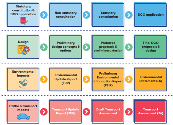
A figure showing an overview of the development of key design, environmental, and transport content at each stage.
A figure showing an overview of the development of key design, environmental, and transport content at each stage.
4.4.3 Statutory consultation
Following the non-statutory consultation and after taking account of what you say, we plan to hold a statutory consultation next year. We will use your previous responses to consultations, other feedback from our engagement programme alongside our own technical research and development and design work to inform more detailed proposals.
The documents for the statutory consultation will include:
- Technical Report
- Preliminary Environmental Information Report
- Draft Transport Assessment
These will provide more details about potential environmental impacts, transport and construction impacts, and how we propose to reduce them. This information will be based on the preliminary results of detailed assessments, such as the modelling of noise and air quality impacts.
After the statutory stage of consultation, we will carry out further work before submitting the DCO application.
5. Operating the railway
This chapter describes our updated plans for operating the railway across the route.
5.1 Train services
Our infrastructure proposals for the project are based on a passenger train service pattern which would provide local communities with fast, efficient and reliable train services that improve east-west public transport connectivity and journey times. We have developed some further updates to the proposed East West Rail services since the route update announcement.
The configuration of stations along the Marston Vale Line may dictate the capacity, stopping pattern and number of direct services to Cambridge from the Marston Vale Line. See Chapter 9 for further details.
A key change has been to extend the train services that run between Cambridge and Bedford to Stewartby. This change allows us to improve our proposals for Bedford station and enhances connectivity to Bedford Hospital.
The proposed train services are:
Table 1: Proposed train service patterns, noting a variation depending on the choice and location of stations on the Marston Vale Line (MVL)
|
Connection stage |
Service pattern with MVL Existing Stations Option |
Service pattern with MVL Consolidated Stations Option |
|
Connection Stage 1 Oxford to Milton Keynes passenger services introduced from 2025 |
2 x Oxford to Milton Keynes services in each direction per hour |
|
|
Connection Stage 2 Oxford to Bedford passenger services introduced from 2030 |
2 x Oxford to Milton Keynes services in each direction per hour
1 x Oxford to Bedford service in each direction per hour
1 x Bletchley to Bedford service in each direction per hour (existing)
|
|
|
Connection Stage 3 Oxford to Cambridge passenger services introduced by mid-2030s
|
Assuming the Existing Stations for MVL stations:
2 x Oxford to Milton Keynes services in each direction per hour
2 x Oxford to Cambridge services in each direction per hour
2 x Stewartby to Cambridge services in each direction per hour
1 x Bletchley to Bedford service in either direction per hour
|
Assuming the Consolidated Stations for MVL stations:
2 x Oxford to Milton Keynes services in each direction per hour
2 x Oxford to Cambridge services in each direction per hour
1 x Stewartby to Cambridge service in each direction per hour
1 x Bletchley to Cambridge service in each direction per hour |
Figure 4: East West Rail train service specification for passenger trains at Connection Stage 3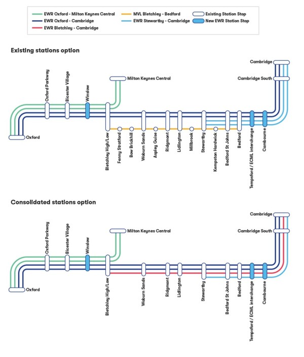
We anticipate that passenger services would run:
- Between 6am and midnight from Monday to Thursday
- Between 6am to 1am on Friday and Saturday
- Between 7am to 11pm on Sunday
5.2 Powering the trains
As part of our route update announcement in 2023, we said we were considering ways to power the trains which align with the UK’s policy on decarbonisation and our aim to be a net-zero carbon passenger railway. The following section explains our latest thinking on how we propose to do this.
5.2.1 What we are proposing and why
In support of the government’s commitments for net zero, our proposals include electrification. We have a preference to use a system known as ‘discontinuous electrification’ along the route. This is explained in more detail below.
5.2.2 Overhead line electrification
We would use an overhead line electrification system to power our trains, which would involve a network of wires above the tracks to supply electric power to the trains. These wires would be supported by masts parallel to the railway. The electric current would be transferred to the trains from the overhead wires (known as overhead line equipment). This is an existing technology and is widely used across railways in the UK and internationally.
The overhead line electrification to power our trains could be done by either discontinuous electrification, which is our preference, or full electrification. With discontinuous electrification, overhead lines would be installed along some sections of the route. In sections where there would be no overhead lines, the trains would use onboard batteries for power. Full electrification would require overhead lines to be installed along the whole length of the route.
Our preference for discontinuous electrification with hybrid battery-electric trains would mean overhead lines would only need to be installed along some sections of the route. It would mean less disruption to existing structures, such as road bridges over the existing railway between Oxford and Bedford, and may have the potential to reduce visual impacts in more sensitive locations on the new railway between Bedford and Cambridge. Recognising funding constraints and the substantial outlay of full electrification, this option would be more affordable and would need less land for things such as foundations for masts.
Hybrid battery-electric trains are a relatively new form of technology, so we need to do more work (surveys, modelling and investigating the train technology) to confirm whether our current preference for discontinuous electrification needs further refinement, particularly in sections of the route that would use the existing rail corridor. However, at this stage our proposals include all the land needed for full electrification should this be identified as the best solution.
5.2.3 Introducing services as quickly as possible
To help local communities enjoy access to faster public transport links as quickly as possible, we are introducing some services as early as 2025. This means that diesel passenger trains will be used temporarily between Oxford and Bletchley/Milton Keynes from 2025 until overheard electrification has been installed. The same approach is likely to be needed for the services between Oxford and Bedford which will operate before the new railway between Bedford and Cambridge, including the overhead electric line system, is complete.
This temporary solution would enable passenger services to operate as and when sections of the route are built, which would in turn take more cars off the roads sooner and help us deliver the benefits of East West Rail to communities as soon as possible.
5.3 Supplying power to East West Rail
To electrify the railway, power supplies would be needed from the National Grid. These would feed substations situated next to the railway, which would then distribute power along the railway via the overhead wires. These substations would be located within secure compounds, with vehicle access for emergencies and maintenance.
We are engaging with National Grid and electricity distribution network operators to assess the best ways of connecting East West Rail to the grid. We are looking to use existing infrastructure wherever this is possible.
A number of potential substation compound locations are being considered in either Quainton or Steeple Claydon, in Millbrook and in Little Barford areas.
- Quainton – power would come from the existing grid site (at Quainton), via a new East West Rail substation, approximately 6km (4 miles) from the East West Rail route.
- Steeple Claydon – as an alternative to Quainton, power could come from the existing grid site, via a new East West Rail substation, that is situated 1.5km (1 mile) from the East West Rail route beside the disused Metropolitan Railway Line south of Verney Junction.
- Millbrook – power would come via a new East West Rail substation in the vicinity of Millbrook Power Station. This power station is currently under construction.
- Little Barford – there is an existing substation that provides power to the East Coast Main Line. This substation would be extended with cabling to the East West Rail route to the east.
Substation compounds in these locations would likely be supported by existing railway electrification compound upgrades in the Oxford, Bedford and north of Cambridge areas. The number of compounds and connections required would depend on whether full or discontinuous electrification is ultimately selected and the amount of power available at each location.
Further details about the need for these substation compounds, and their potential locations, can be found in Chapter 14 of the Technical Report.
5.4 Stabling trains and maintaining the railway
To enable the smooth and reliable running of East West Rail for passengers, we would need places to stable and maintain trains while they are not in service, and facilities to support maintenance of the track and other infrastructure. We would require a train maintenance depot for the stabling, inspection, cleaning and maintenance of trains. It would be within a fenced compound that would include various maintenance buildings, storage areas, offices, car parking and welfare facilities for staff.
Additional sidings would be needed along the route to stable trains when not in use. Whilst stabled, routine light servicing and cleaning would be carried out on trains.
A main infrastructure maintenance depot and several smaller satellite depots would be needed for the storage of spare parts, tools and equipment. Again, these would take the form of a fenced compound and would include offices and welfare facilities for staff, as well as car parking.
A series of access points would be provided alongside the railway to facilitate maintenance. These would be gated points of access from the local road network.
We are currently considering the best locations for these facilities. We would prefer to use existing Network Rail facilities for the infrastructure maintenance depot but, as a backup, we are still looking at locations for a standalone site. More information about these facilities and the areas we are considering for their locations is provided in Chapter 14 of the Technical Report. We will confirm our proposals at our statutory consultation, having considered feedback received and following further design development.
5.5 Passing loops
To deliver a faster and more reliable service for passengers, we would need passing loops along the full length of the East West Rail line.
A passing loop is an additional section of track laid parallel to the main line which allows faster trains to overtake slower trains, providing flexibility and reliability of service, and ensuring that even a limited freight service does not undermine the experience for passengers. Proposed locations for passing loops are described in the route section chapters of this document.
5.6 Level crossings
Level crossings are a key point of interaction between an operational railway and members of the public, where the railway crosses a road or path. They are the legacy of the era in which much of the British railway network was built, when both the railways and roads were quieter. As our railways and roads have become busier, level crossings have come to be associated with traffic problems due to barriers remaining closed for longer and are one of the most dangerous parts of the rail network for people. For these reasons, it is not permitted to build new level crossings on the rail network today.
We recognise though that some existing level crossings provide important connections and access routes for people living and working on either side of the railway. Where it is appropriate and safe to do so, we have sought to retain and upgrade existing level crossings to maintain these important connections. However, in some cases the increased speed and frequencies of the new train services mean it would be unsafe to retain the level crossing. Where this is the case, we propose to close the level crossing and provide an appropriate diversion or alternative crossing.
At our route update announcement, we provided proposals for maintaining connectivity across the railway and indicated which existing level crossings may be retained, upgraded or closed. The assessment was based on a balanced view of safety, cost, engineering impacts and the need to maintain connectivity for communities. In line with regulations, no level crossings are proposed for the new section of railway between Bedford and Cambridge. Bridges and other structures would be constructed to enable the railway to cross existing highways and other routes.
Since our route update announcement, we have carried out further design development, risk assessments and traffic assessments. In doing so, we have considered opportunities for enhancing existing level crossings through modern technology, to allow existing connections to be maintained.
Modern level crossings provide a safe way for people to cross the railway, whether in vehicles, on foot, bike or horseback. Where we are proposing to keep level crossings, we have considered the following types:
- Miniature stop light level crossings are designed for footpaths or private roads. A small set of red/green lights let the user know whether it is safe to cross.
- Manually controlled barriers monitored by obstacle detection level crossings use RADAR and LIDAR to check that the crossing is clear before closing the barriers for the train to pass. If an obstruction is detected, the oncoming train will stop and the signaller will intervene.
- CCTV level crossings are operated by a signaller who has a clear view of the crossing from CCTV cameras.
The proposals for each level crossing along the route are reported within the relevant route section chapters, both in this Consultation Document and the Technical Report. We will continue to engage with stakeholders and will take account of feedback to inform our final proposals which will need to be endorsed by the Level Crossing Review Panel at Network Rail, which considers every level crossing on the national rail network.
5.7 Our approach to freight
East West Rail’s primary purpose is to provide connectivity between communities and support economic growth as a passenger service. Alongside this, and noting that freight already runs on sections of our route, government has asked us to consider how we:
- Maintain existing freight services that already run through commuter hubs including Oxford, Bicester, the Marston Vale and Bedford.
- Plan for increased future freight demand to enable wider economic growth.
These considerations need to be balanced against the required level of investment and the impact to local communities.
Our work indicates that the likely demand for additional freight services would depend on further investment in infrastructure beyond East West Rail. Within our current proposals, and without additional investment beyond the project, East West Rail would allow for:
- Up to two new freight services per day in each direction from Felixstowe via Cambridge through to Oxford and beyond.
- Up to two new freight services per day in each direction from Southampton via Oxford, Bletchley and onto the West Coast Main Line once the first phase of East West Rail is complete.
- Up to ten additional freight services per day in each direction between Oxford and Milton Keynes – connecting onto the West Coast Main Line – once East West Rail is fully operational.
Even with the limited uplift in freight services made possible by East West Rail, this could replace up to an estimated 250,000 lorry journeys every year, which would be around 980 lorry journeys per day.
We have considered the broader range of opportunities for freight trains. Additional services, particularly from the east of England, could use the route in future, but this would only be possible with significant additional investment and infrastructure both on the East West Rail and the national network.
6. Delivering the railway
This section sets out how we will deliver the railway infrastructure across the route.
6.1 Environment and sustainability
At each stage of planning and developing East West Rail we work to ensure nature has a central place in our plans. We want to change the environment for the better, including delivering biodiversity net gain. We will continue to take a proactive approach to avoid, reduce and mitigate negative environmental impacts to deliver a sustainable railway.
Since 2021, we've updated our Environmental Sustainability Strategy in response to the government setting out its environmental goals. We are committed to delivering 10% biodiversity net gain for the project. Providing a biodiversity net gain means that the development will have a measurably positive impact (‘net gain’) on biodiversity, compared to what was there before the development. Achieving a biodiversity net gain means taking action to improve and increase the level of biodiversity rather than simply replacing what is lost.
We have already been putting our approach into practice between Bicester and Bletchley on Connection Stage 1, creating twenty ecological compensation sites and recreating habitats for protected species of wildlife such as barn owls, great crested newts, badgers, bats and otters. We will take this approach along the route to Cambridge.
You can read more about our Environmental Sustainability Strategy in www.eastwestrail.co.uk/environmentalsustainabilitystrategy
Figure 5: The six pillars of our Environmental Sustainability Strategy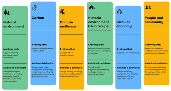
As we develop our proposals we are considering existing environmental information and carrying out surveys to increase our understanding of potential impacts on nature and species. We have taken steps to design proposals that avoid environmental impacts, for example by planning the alignment of the railway to avoid sensitive sites and habitats.
Where we have not been able to avoid impacts, we have included initial mitigation measures in our early designs, such as:
- Potential locations for noise mitigation measures, such as barriers or bunds.
- Areas of habitat enhancement and replacement, such as hedgerow improvements or woodland creation.
- Measures to maintain connections between habitats, such as green bridges to allow bats to pass safely from one side of the new railway line to the other.
- Landscaping areas to create screening, for example by creating new woodland.
An environmental impact assessment (EIA) is being carried out as part of the development of our proposals. The EIA is an ongoing process that helps us to identify environmental constraints and opportunities to feed into the design of the project as it evolves. We will present further information collected from the EIA in a Preliminary Environmental Information Report at our statutory consultation. The full results of the EIA will then be presented in an Environmental Statement which will be submitted as part of our DCO application. This will identify the likely significant effects of the project and the mitigation measures we are proposing.
You can find our initial environmental information based on the studies carried out so far in our Environmental Update Report.
6.2 Effects on traffic and transport
We have undertaken initial analysis to help understand the potential impacts on transport networks which could occur during the construction and operation of the project. This will help us to identify measures to avoid or reduce potential disruption to the journeys of people who live and work in the area.
The assessment uses information on existing traffic conditions and predicted future conditions. We then use a Strategic Highway Model as a tool to assess the likely impacts that the project could have on these conditions.
Our assessment of the likely levels of construction traffic associated with the project is based on the average levels of vehicle movements we would expect during the peak month of construction across the route. This provides a consistent and ‘maximum most likely’ basis that we use to compare and assess construction impacts across the entire route.
We have prepared a Transport Update Report which contains an initial qualitative assessment of the potential impacts of our proposals on the road network, making use of available information. The report also sets out a preliminary strategy for mitigating those impacts.
We will continue to assess the potential traffic and transport impacts and use the results to inform the ongoing development of our proposals. We will present further information in a Draft Transport Assessment at the statutory consultation. The full results of our assessments will be presented in a Transport Assessment submitted as part of our DCO application.
Further information on traffic and transport matters can be found in the Transport Update Report.
6.3 Public rights of way, highways and private access roads
We have considered the impact of the new railway on existing public rights of way, highways and private access roads.
We will seek to maintain existing public rights of way, highways and accesses wherever possible. Where it is not feasible or safe to keep public rights of way in their current location, we will seek to provide suitable alternatives which reduce the impact on communities and take account of the needs of all users, accessibility and equality considerations. In a few instances we may permanently close short sections of public rights of way where they no longer serve a purpose as a consequence of the project.
During construction we would seek to maintain connections that are temporarily affected by the works. This may include the creation of temporary diversions.
More detail on the principles we have applied when considering public rights of way, highways and accesses can be found in Chapter 3 of the Technical Report. Proposals for individual public rights of way, highways, and public and private access roads can be found in the route section chapters of this Consultation Document and the Technical Report.
6.4 Homes, land and property
To build and operate the railway we would need to acquire land and property. Where possible, we would use existing railway land. However, in some places our proposals would mean we need to acquire other property which includes residential properties, businesses and agricultural land. As we develop our proposals, we are seeking to reduce the impact on land and property owners and on sensitive environmental features and historic landscapes.
The proposals we’re presenting at this consultation show the extent of land that has been identified at this stage as potentially needed to build and operate the new railway. The Secretary of State for Transport has safeguarded land within this area.
We understand that publishing our proposals may affect people who want to sell their property. We introduced our discretionary Need to Sell Property Scheme at the route update announcement in 2023. This provides early and ongoing support for those property owners who have a compelling need to sell their property but are unable to do so, other than at a substantially reduced value, because of our proposals.
With the launch of this consultation, we’re able to go further. Safeguarding this land means that statutory blight provisions now apply. If you own and occupy a property in the safeguarded area and you would like to move, you may be eligible to serve a blight notice asking us to buy your property before we need it to build the railway.
If you’re not eligible to serve a blight notice you may be able to apply for us to buy your property under the Need to Sell Property Scheme. Your property does not need to be within the safeguarded area for you to be eligible to apply under the scheme. You can find more information on statutory blight notices and the Need To Sell Property Scheme on our website at eastwestrail.co.uk/planning/land-and-property
The Safeguarding Direction means that local planning authorities must consult us about relevant planning applications for development within the safeguarded area that could conflict with the railway. This consultation allows us to comment on potential conflicts and suggest measures that could be taken to resolve them and, where possible, allow development to go ahead. More information on safeguarding, including the Safeguarding Direction and plans of the safeguarded area, is available on our website at eastwestrail.co.uk/safeguarding
We have sent letters to land and/or property owners directly affected by the proposals detailing how their land may be impacted. This letter provides information on the proposals and the implications for their property, ensuring that they have the opportunity to engage in the consultation process.
As part of this consultation, the project boundary (the draft Order Limits) includes land that would need to be permanently acquired, and land that would be used temporarily for construction. This includes proposed locations for construction compounds. It also includes land where we may need to acquire permanent rights, for example for accesses or diverted utilities. We have published a set of plans and drawings that provide information on the anticipated use of land within this boundary.
As our proposals develop, we will continue to seek to reduce the impact of our proposals on homes, land and property where possible. We will seek to enter into agreements with property owners to acquire the property that we need and to agree measures to reduce the impacts of our proposals. However, to provide the certainty that we can acquire all the necessary land and property, we will seek the appropriate powers for compulsory acquisition in our DCO application.
We understand that land and property owners will be concerned by the possibility that we may need to purchase your property. We will follow these five principles to try to reduce the impact on you if your land and/or property is potentially affected by our proposals:
- Keep you updated – we will keep you updated and informed throughout as our proposals develop.
- Act with respect – we will treat you, your land, property and personal data, and third parties acting for you with respect. We will work collaboratively with you and any third parties acting for you.
- Reduce land loss – we will discuss our proposals with you, so we understand and manage the potential impacts to you. We aim to reduce the impact our proposals may have on your land and property and mitigate any impacts we can’t avoid where possible.
- Agree fair compensation – we will seek agreements with you to acquire your land and property needed for our proposals. Where we need to acquire your land, we will compensate you fairly in accordance with the compensation code.
- Provide dedicated case managers – our specialist Land and Property team will get in touch so that you have consistent and well-briefed contacts on our proposals.
We have produced a factsheet Our approach to land and landowners with more information on our website at https://eastwestrail.co.uk/consultation2024
6.5 Construction
We recognise that constructing the project would have an impact on local communities, businesses and the environment. As part of our design development, we are assessing these impacts and how they could be mitigated. The plans we are presenting as part of this consultation include high-level information on how we would construct the railway. We’re at a very early stage of developing our construction approach and would like to hear your feedback to help us shape our more detailed plans that we will present at our statutory consultation.
Figure 6: Construction works and track laying on Connection Stage 1 (Oxford to Milton Keynes)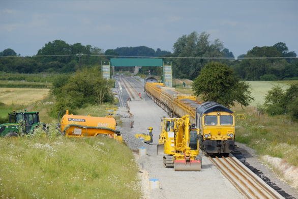
We are committed to regular engagement with communities and businesses potentially affected by the construction of the project as we design the proposals, plan our approach to construction, and build the railway. We will continue to keep you informed and listen and respond to your concerns.
We will develop and submit a draft Code of Construction Practice (CoCP) as part of our DCO application. The CoCP will set out a range of mitigation measures and principles which contractors would be required to follow when building the project, including engaging with stakeholders and the community. The project would be delivered by contractors and supply chain partners with experience in successfully delivering major infrastructure projects and managing the related impacts.
We would:
- Consult on, seek to agree and communicate plans for temporary diversions or road closures with local authorities, National Highways and the emergency services to check that suitable options have been considered.
- Strictly control construction traffic.
- Define and control normal site working hours and any exceptions.
- Develop travel plans for workers at each construction location, including parking controls in residential streets and use of construction workforce shuttle buses, with public transport prioritised where possible.
- Wherever possible, seek to apply best practice construction methods such as standardisation of design, modularisation and off-site fabrication and assembly.
- Apply industry best practice to control noise, dust, vibration and light pollution.
We would create a series of temporary construction compounds along the route and would use main and satellite compounds which would vary in size. Depending on the work being delivered from each compound, they would provide welfare facilities, offices, car parking, storage and other facilities.
Potential locations for temporary main construction compounds are identified on the plans provided as part of this consultation. We are considering these locations to enable us to deliver construction efficiently and reduce disturbance to local communities and the environment. For each compound, we are carefully considering how much land would be needed, traffic routing and access arrangements. We will share further information on this at our statutory consultation.
We are engaging with other current and future development and infrastructure projects in the vicinity of East West Rail, to manage how the project might impact them, and how projects in combination could affect local communities. This includes, for example, Oxford station redevelopment works and Cambridge South station, as well as the A428 Black Cat to Caxton Gibbet improvements scheme. We are looking to reduce any combined effects and identify how we can be efficient in the way we deliver alongside these projects to minimise disruption and other negative impacts.
6.6 Utilities
In some locations our proposals would impact existing underground and overhead utilities, such as gas mains or power cables, which may need to be protected or moved.
We are engaging with utility companies to understand where their apparatus may be affected by our proposals and discussing the work required to protect and maintain supplies. We aim to minimise any disruption associated with utility works.
The land needed for major diversions and new power supplies is included in the draft Order Limits shown on the plans presented at this consultation. The land identified in each case includes the diversion route, the required working space and site access requirements. These are initial proposals and may be subject to change following our ongoing discussions with utility companies.
7. Our infrastructure proposals
The following chapters describe our infrastructure proposals for the project. We have split the route into the following eight route sections:
- Oxford to Bletchley.
- Fenny Stratford to Kempston.
- Bedford
- Clapham Green to Colesden.
- Roxton to east of St Neots.
- Croxton to Toft.
- Comberton to Shelford.
- Cambridge
Each route section chapter covers:
- An overview of what we are proposing and why.
- How we have considered the environment when developing our proposals.
- More detailed information about the proposals for specific locations.
- How to have your say.
Figure 7: Map showing the eight route sections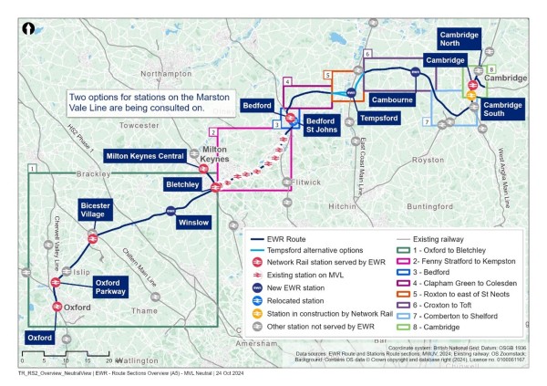
8. Route section – Oxford to Bletchley – improvements to the existing railway and stations
In this part of the Consultation Document, we outline new infrastructure proposals for the section of the existing railway route between Oxford and Bletchley, which is approximately 48km (30 miles) long.
This chapter covers:
- What we are proposing and why – including how our proposals have developed since last year’s route update announcement.
- How we have considered the environment when developing our proposals.
- Specific proposals around:
- Oxford
- Oxford station.
- London Road level crossing, Bicester.
- Oxford Parkway, Bicester Village, Winslow, and Bletchley stations.
- Islip passing loop.
- Middle Claydon passing loop.
- How to share your feedback using the feedback form.
8.1 What we are proposing and why
We are proposing improvements to the existing railway between Oxford and Bletchley to enable four East West Rail services to run per hour in each direction along this section.
These proposals would supplement improvement work between Bicester and Bletchley currently being delivered by Connection Stage 1, which will reopen a renovated section of the Varsity Line, the original main line which connected Oxford to Cambridge, and introduce two East West Rail passenger services in each direction per hour between Oxford and Milton Keynes in 2025.
The proposals are needed to allow for the increase in train services and to enhance the overall efficiency and capacity of the railway network between Oxford and Bletchley. These services will better connect businesses and academia in Oxford with their current and future workforce and help people in Oxford access opportunities across the region.
We are working closely with Network Rail to integrate our proposals with ongoing work they are carrying out to improve rail services in the Oxford area, notably the work currently underway at Oxford station. We are also considering how trains could continue beyond Oxford to provide a better service for passengers as well as relieving pressure on the station. This includes exploring the potential for East West Rail merging with other train services south of Oxford such as the existing Didcot service or the proposed Cowley service. Integrating our work will mean less disruption for communities as we seek to combine construction work as far as possible.
How proposals for Oxford to Bletchley have developed
After the 2021 non-statutory consultation, we reviewed your feedback on the proposals between Oxford and Bletchley. This feedback was used to inform revised proposals for this section of the route which we shared at the route update announcement in May 2023. This included plans for further infrastructure in the Oxford area to increase the capacity of the railway. We also confirmed we were carrying out further analysis to identify the best option for the London Road level crossing in Bicester.
Here's what we are proposing for this section of the route, and why:
- In and around Oxford station, we are looking at what changes and new facilities might be needed to enable four East West Rail trains to run per house to serve Oxford station, to benefit passengers and complement other projects already planned in the area.
- At Oxford Parkway, Bicester Village, Winslow and Bletchley stations we are thinking about what changes to the stations and parking facilities might be needed to benefit passengers. At Oxford Parkway we are also looking at whether we would need to divert an existing overhead electricity line to provide sufficient clearance of electrification of East West Rail trains.
- At Islip, we are proposing to construct a passing loop so that faster passenger services heading towards Oxford can pass by slower trains including freight without delay, improving the efficiency and punctuality of East West Rail Services.
- At the London Road level crossing in Bicester, we are proposing to close the level crossing and are considering two options to provide an accessible replacement crossing for pedestrians, cyclists and other users of the crossing, to make sure people can still access Bicester safely and easily. Road traffic would be re-routed via existing roads with local road improvements to reduce travel times.
- At Middle Claydon, we are proposing to construct a passing loop so that faster passenger services heading towards Oxford can pass by slower freight trains without delay.
- At Quainton, East Claydon and Verney Junction, we are considering drawing electrical power from the Quainton substation or the East Claydon substation, to help power East West Rail trains.
Work we have done since the route update announcement
Since last year’s route update announcement, we have listened to feedback and have been developing and refining our proposals for this section of the route.
These improvements are critical for accommodating the anticipated increase in train services and enhancing the overall efficiency and capacity of the railway network between Oxford and Bletchley.
Here’s what we are proposing for this section of the route, and why:
- In and around Oxford station, we are looking at what changes and new facilities might be needed to enable four East West Rail trains to run per hour to serve Oxford station, to benefit passengers and complement other projects already planned in the area.
- At Oxford Parkway, Bicester Village, Winslow, and Bletchley stations we are thinking about what changes to the stations and parking facilities might be needed to benefit passengers. At Oxford Parkway we are also looking at whether we would need to divert an existing overhead electricity line to provide sufficient clearance for the electrification of East West Rail trains.
- At Islip, we are proposing to construct a passing loop so that faster passenger services heading towards Oxford can pass by slower trains including freight without delay, improving the efficiency and punctuality of East West Rail services.
- At the London Road level crossing in Bicester, we are proposing to close the level crossing and are considering two options to provide an accessible replacement crossing for pedestrians, cyclists and other users of the crossing, to make sure people can still access Bicester safely and easily. Road traffic would be re-routed via existing roads, with local road improvements to reduce travel time.
- At Middle Claydon, we are proposing to construct a passing loop so that faster passenger services heading towards Oxford can pass by slower freight trains without delay.
- At Quainton, East Claydon, and Verney Junction, we are considering drawing electrical power from the Quainton substation or the East Claydon substation, to help power East West Rail trains.
Figure 8: Map showing the Oxford to Bletchley route section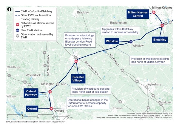
How we have considered the environment when developing our proposals
As we continue to develop our proposals for this section of East West Rail, we are thinking carefully about a number of environmental matters, including:
Landscape and visual
- We will carry out a landscape and visual impact assessment to understand potential impacts. For example at Oxford Parkway, Bicester, around Islip, Middle Claydon, Verney Junction, west of Winslow, and Bletchley the removal of vegetation would open up views of the existing railway. We will design our proposals to mitigate these visual impacts as far as possible.
Biodiversity and nature conservation
- Protection of ancient woodland and other key habitats will be a key feature of our design and mitigation proposals. There are some protected sites immediately adjacent to the draft Order Limits including Sites of Special Scientific Interest (SSSIs) such as the Port Meadow with Wolvercote Common and Green SSSI, and the Hook Meadow and The Trap Grounds SSSI, both located to the north of Oxford station. The large Sheephouse Wood SSSI is a substantial ancient woodland, located just south of Calvert adjacent to the draft Order Limits. Our assessments will determine whether mitigation is required such as habitat replacement or enhancement.
Water resources
- Our assessment will determine suitable measures to ensure our works would not deteriorate the water quality and characteristics of at least seven surface water catchments and other water bodies in the area, including Thames (Evenlode to Thame), Cherwell (Bletchingdon to Ray), Gallos Brook, Langford Brook (Bicester to Ray inc Gagle Brook), Langford Brook (source to downstream A41), Summerstown Ditch and Launton and Cutters Brook, and Claydon Brook (DS Granborough).
Historic environment
- We will undertake an assessment of any significant heritage impacts, and incorporate appropriate mitigation in our designs. This will consider the potential impact of works south of Oxford station on the setting of a group of listed buildings to the east of Beckett Street, and Rewley Abbey scheduled monument. We will also assess the potential impact of utility works in on the scheduled Roman site of Alchester, south of Bicester.
Initial information about potential impacts and mitigation concepts in this section of the route are provided in Chapter 5 of the Environmental Update Report.
8.2 Oxford
The existing route is a four-track railway heading north out of Oxford for just over a mile (1.6km), before it turns east to join the two-track railway heading towards Bicester.
Figure 9: Oxford station
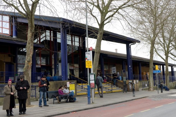
We want to make sure Oxford's rail infrastructure can support our proposed service of four trains per hour in and out of Oxford, which will benefit passengers and support regional growth. We are undertaking studies to determine what infrastructure or service changes may be needed in the Oxford area to provide additional capacity on this section of the railway for East West Rail services to operate reliably.
Network Rail is carrying out capacity improvement works at Oxford station as part of the Oxford station Phase 2 project. This includes track crossovers, a western entrance to the station, the construction of platform 5, and bridge works at Botley Road and Sheepwash Channel.
At the route update announcement, we shared that we were exploring a range of further options – a timetable that ensures trains can run smoothly, infrastructure that allows trains to change direction, additional crossovers that allow trains to switch between different tracks, and the addition of a partial running line to increase capacity. We also described how East West Rail would interface with current and future rail enhancement schemes including Network Rail’s Oxford Phase 2 and the proposed Cowley Plus project.
Our subsequent analysis suggests that solely providing crossovers would not provide sufficient additional capacity, and the addition of a partial running line to the north of Oxford station would be too short to provide the required benefits.
At the time of this consultation, we are continuing to undertake analysis to enable four East West Rail trains per hour in and out of Oxford. We will identify the best solution and consider alternatives such as the requirements for crossovers, passing facilities and operational solutions to unlock capacity. Operational solutions include exploring East West Rail trains merging with other train services south of Oxford such as the existing Didcot service or the proposed Cowley service. We will continue to develop our proposals in close collaboration with Network Rail and other stakeholders. The outcome of this will be shared at the statutory consultation.
We are aware that Network Rail is considering proposals to reopen the Cowley Branch Line to passenger services, subject to funding and business case viability. If this goes ahead, it could provide an option for East West Rail trains to turn back, providing additional capacity at Oxford station.
Figure 10: Overview of Interfacing projects in the Oxford area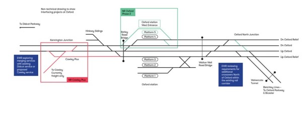
8.3 Oxford station
Our initial analysis has indicated that the layout of Oxford station may need some further changes, such as to stairways and platform access, to accommodate the increased number of passengers expected from East West Rail services. We will be completing demand analysis and pedestrian modelling to identify what layout changes would be required, and what other work could be needed in the future as more people use the services. We will share more detail with you on this at the statutory consultation.
A new train crew facility would be required in the Oxford area for use by East West Rail staff. We are still identifying the best location for this and will provide further details at the statutory consultation.
We are also engaging with Network Rail to coordinate our proposed improvements to the station with other enhancements that are being planned in the area. We are conducting further operational and engineering analysis of options to determine the right solution.
8.4 London Road level crossing, Bicester
East West Rail services would travel over the existing level crossing on London Road, Bicester.
Figure 11: London Road level crossing 
At the route update announcement, we set out how we are trying to address several competing priorities in relation to the London Road level crossing.
We highlighted that:
- We recognise the importance of connectivity in Bicester.
- The barriers are currently down for approximately 10 minutes per hour while trains are running.
- With the addition of East West Rail services, the barriers would need to be down for much more time, resulting in significantly increased waiting times for people.
- The potential for traffic congestion would therefore increase, and there would be a significant safety risk due to potential misuse of the crossing.
- There are challenges with replacing the crossing with a road bridge: the significant visual impact on the town, the difficulty of its construction and high cost.
Noting these challenges, we said we were continuing to investigate ways to maintain connectivity for pedestrians and motorists, including carrying out a further level crossing risk assessment, an assessment of the amount of time the barriers would need to be down and traffic modelling.
Our further analysis has confirmed that, with four East West Rail trains per hour in each direction in addition to existing services, the minimum barrier down time at the level crossing would likely exceed 32 minutes per hour. This would create several significant issues:
- The waiting times for pedestrians, motorists and other users would not be acceptable as London Road would be closed for the majority of each hour during the day.
- There would be a significant impact on the build-up of traffic to the north and south of the crossing, with queuing expected to back up to Market Square and the A41/A4421 roundabout respectively. Our assessments indicate that the amount of queuing traffic would double.
- As a result of the increased waiting times, the potential for misuse of the crossing would also increase, raising safety concerns if the crossing is left open.
- The risk of people dying or being injured at the crossing would increase by more than 300%. This is based on an assessment using a model known as the Fatalities and Weighted Injuries score.
Public safety is paramount. We have given this matter careful consideration and our assessment is that the safety risk to the public would be unacceptably high and therefore the London Road crossing would need to be closed.
We have considered whether the crossing could remain open to local traffic only. Our assessment is that it would not be practical to restrict access to local traffic only, as London Road is used by motorists from the wider area. It is a through route, so any restriction would be difficult to enforce.
Road bridge options
We recognise the importance of maintaining good connectivity in Bicester and we have looked at options to create a new vehicle crossing. We have considered two road bridge options:
- A new bridge adjacent to the existing level crossing. This would be a very large structure – twice as high as other structures in the vicinity – that would have a significant visual impact, especially for nearby residents and local businesses.
- A location at Gavray Drive, which is away from the crossing and would require demolition of several commercial premises on the retail park off Launton Road, Lidl and Wickes. It would also jeopardise the proposed development of 300 residential properties and may lead to increased traffic on less suitable residential roads.
We found that neither option provided a material time-saving to people’s journeys compared to using alternative routes.
Existing road diversions
Our preferred solution is for traffic to be diverted using existing roads. Motorised traffic could feasibly be diverted onto existing roads without motorists incurring significant delays or disruption. There would be some additional waiting times at current road intersections, but these are not material enough to warrant the impact and costs of the two options for a new road bridge. For these reasons, our preference is to close the crossing and use existing and upgraded local road diversions.
More detail on the road bridge options and the diversions can be found in Chapter 6 of the Technical Report.
We are looking further at the alternative routes that drivers would take and are exploring opportunities to introduce upgrades to local roads, such as improvements to junctions and traffic calming measures. This would help to reduce journey times and prevent use of inappropriate roads.
We look forward to engaging with local communities, businesses and other stakeholders on how road upgrades could reduce the additional journey time for more people at lower cost.
Figure 12: Map showing the London Road level crossing motorised user diversions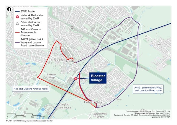
Replacement crossing for pedestrians, cyclists and other non-motorised users
Whilst we propose that the level crossing should be closed, we are considering two options to provide an accessible replacement crossing at London Road for pedestrians, cyclists and other users of the crossing. The replacement crossing would either be a footbridge (Option 1a) or an underpass (Option 1b).
Option 1a (footbridge)
The footbridge option would provide both stairs and ramps on each side of the railway. The design would be inclusive so that the footbridge is accessible for everyone.
The advantages of a footbridge would be:
- The footbridge would be cheaper to build than the underpass and relatively simple to install.
- The railway would only need to be closed on a small number of occasions to install the footbridge, meaning less disruption to the public.
- People using a footbridge typically feel safer than using an underpass as you are out in the open.
These would need to be considered against the disadvantages:
- The footbridge would take longer for people to use than the underpass when making use of the ramp.
- There would be a significant visual impact on the local surroundings.
Figure 13: Indicative illustration of Option 1a: Traffic diversion and accessible footbridge for pedestrians, cyclists and other users at London Road
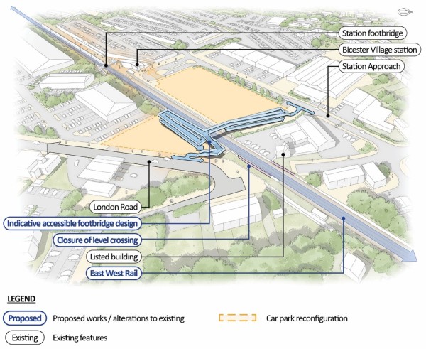
Option 1b (underpass)
The underpass option would be located at the site of the existing level crossing with shallow gradients from its lowest point beneath the railway, up to street level on both sides of the railway. The design would be inclusive so that the underpass is accessible for everyone.
The advantages would be:
- The underpass would be quicker for people who would need to use the ramp.
- People using the underpass would be partially protected from adverse weather conditions.
- This option presents less visual impact on the local surroundings.
The disadvantages would be:
- The underpass may create safety concerns for members of the public due to its enclosed nature.
- The construction work to install the underpass would require the railway being closed for longer than if a footbridge is constructed.
- It would be more expensive to construct and maintain.
Figure 14: Indicative illustration of Option 1b: Traffic diversion and an accessible underpass for pedestrians, cyclists and other users at London Road
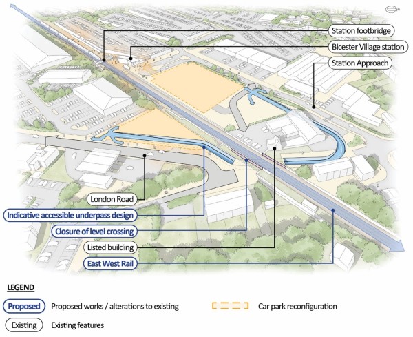
8.5 Oxford Parkway, Bicester Village, Winslow, and Bletchley stations
Figure 15: Oxford Parkway station
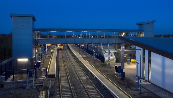
At Oxford Parkway, Bicester Village, Winslow and Bletchley stations, we may need to make some changes to accommodate the increased demand from East West Rail services between Oxford and Cambridge.
We may need to make minor layout changes to the stations, such as changes to the gate barriers and entranceways, to better accommodate the increased number of passengers and reduce potential crowding. We will be completing demand analysis and pedestrian modelling to identify what changes to station layouts are required when East West Rail services start and what interventions would be required in the future as demand grows. We will provide more detail on this at the statutory consultation.
We are conducting an analysis of the amount of parking that may be required at the stations as a result of East West Rail demand. Dependent on the outcome of this we may need to expand the station car parks to provide more parking spaces.
At Oxford Parkway it is likely that an upgrade to the car park entry junction on Oxford Road would be needed to handle increased traffic. New and larger drainage ponds would also need to be provided. Furthermore, at Oxford Parkway we are considering a turnback facility to add additional resilience and operational flexibility by providing a place for trains to turn back.
A new train crew facility would be required in the Oxford area for use by East West Rail staff. Oxford Parkway is one of the areas we are exploring for this.
Bletchley station would become a key interchange for passengers to connect between East West Rail and the West Coast Main Line, as well as integrating with local services between Bletchley and Milton Keynes. In partnership with Milton Keynes City Council and Network Rail, we are contributing to the development of a comprehensive vision and masterplan for the Bletchley area, funded in part by economic growth funding announced in the 2023 budget. Our aim is to work with local authorities and stakeholders to improve the station's connectivity with the surrounding community, enhance the public realm and promote sustainable growth by offering new connectivity and active travel options.
Since the route update announcement, we have reviewed potential improvements to Bletchley station. Initial analysis has indicated that the required works may include:
- An expanded west ticket hall to streamline access and reduce congestion.
- A new platform 1 staircase or widening to the existing staircase.
- Widening of platform 6 and a new platform 6 lift.
- Potential extension of platforms.
- Extensions or widening of the existing footbridge, or a new footbridge.
As part of the work with Milton Keynes City Council, we are also testing the strategic and economic case for a new eastern entrance to the station at Bletchley.
Figure 16: The view of the new high-level platforms 7 and 8 at Bletchley under construction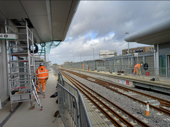
8.6 Islip passing loop
We are proposing the construction of a westbound passing loop north-east of Islip station. The new section of track would be laid immediately south of the existing tracks and would allow faster passenger trains travelling towards Oxford to overtake slower trains including freight, without delaying their journey.
The proposed passing loop location was established through a detailed evaluation of various factors including environmental impact, cost, and the potential to improve operational performance. For more detail, please see Chapter 6 of the Technical Report.
Figure 17: Map showing the Islip passing loop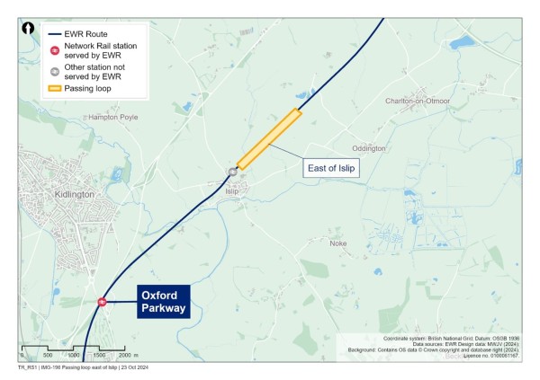
We would need to carry out some changes to the embankments to make room for the additional track. We would need to demolish the existing footbridge and provide a new longer footbridge at the same location to maintain the existing public rights of way.
8.7 Middle Claydon passing loop
We are proposing a westbound passing loop in Middle Claydon in Buckinghamshire, between the villages of Steeple Claydon and East Claydon.
The passing loop involves a short section of new track being added next to the existing tracks on the south side of the railway. A signalling system would also be installed.
The passing loop is needed to ensure East West Rail provides a fast reliable passenger service. Specifically, the passing loop would allow faster passenger trains travelling towards Oxford to overtake slower trains including freight, without delaying their journey.
The passing loop would be positioned to the east of the Queen Catherine Road overbridge.
The proposed passing loop location was established through a detailed evaluation of various factors including environmental impact, cost, and the potential to improve operational performance. For more detail, please see Chapter 6 of the Technical Report.
We would need to carry out some changes to the embankments to make room for the additional track and to extend the existing footbridge to maintain the existing public rights of way.
Figure 18: Map showing the Middle Claydon passing loop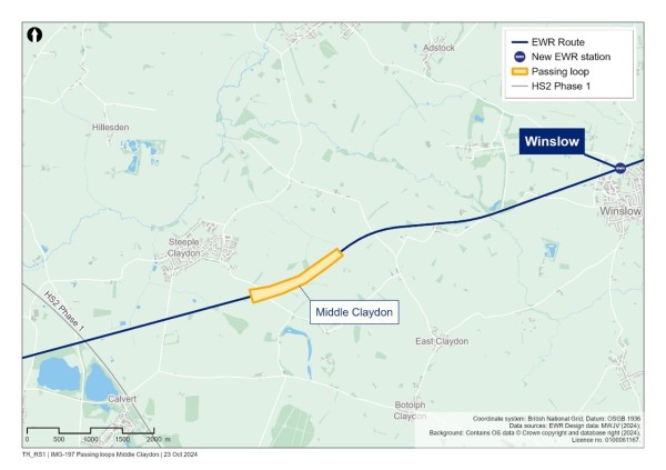
8.8 Share your feedback
We would like to hear your feedback on our proposals for the Oxford to Bletchley route section. We are particularly interested in your views on:
- Whether you prefer the footbridge or underpass option at London Road level crossing in Bicester.
- Issues and opportunities we need to consider when developing the proposed traffic diversion for vehicles as a result of the closure of the London Road level crossing in Bicester.
- Factors we should consider when designing any changes to the station layouts at Oxford Parkway, Bicester Village and Bletchley.
- Issues and opportunities we should consider when developing our plans for passing loops at Middle Claydon and Islip.
You can find details of how to respond to our consultation in the Have your say section of this Consultation Document.
9. Route section – Fenny Stratford to Kempston (the Marston Vale Line) – improvements to the existing railway and stations
This chapter of the Consultation Document outlines new infrastructure proposals for the Fenny Stratford to Kempston section of East West Rail, which forms part of the Marston Vale Line that runs from Bletchley to Bedford. This section of the East West Rail route is approximately 23km (14 miles) long between Saxon Street dual carriageway and Bedford, passing through Bletchley, and Ampthill Road in Kempston. This section of the railway is currently used by London Northwestern Railway passenger trains and freight trains.
In this chapter, we refer to this section of the route as the Marston Vale Line because it describes our proposals for the services that operate along the whole of the Marston Vale Line. Infrastructure proposals for the other sections of the Marston Vale Line (the Bletchley, Bedford St John and Bedford area infrastructure proposals) are described in the Oxford to Bletchley and Bedford chapters of this Consultation Document.
This chapter covers:
- What we are proposing between Fenny Stratford and Kempston and why – including how proposals have developed since last year’s route update announcement.
- How we have considered the environment when developing our proposals.
- Options being considered for service patterns and stations on the Marston Vale Line. The options would either retain all nine existing stations or consolidate them into four new stations at:
- Woburn Sands
- Ridgmont
- Lidlington
- Stewartby
- Fenny Stratford twin-tracking.
- Our approach to level crossings on the Marston Vale Line.
- Passing loops between Ridgmont and Stewartby.
- How to share your feedback using the feedback form.
Accelerating Connection Stage 2 and what this means for the Marston Vale Line
In Chapter 5 of this Consultation Document, we set out plans for the acceleration of Connection Stage 2, to deliver an East West Rail service between Oxford and Bedford from 2030. This has been made possible through government funding for the early delivery of infrastructure works. The works comprise modifications to nine level crossings on the Marston Vale Line, authorised by a Transport and Works Act order made by the Secretary of State in 2020, as well as track renewals and supporting works to be delivered through permitted development rights. Whilst these works will bring forward an initial new train service between Oxford and Bedford, there is further work in that area, described in this section, that would be needed to enable the full operation of trains between Oxford and Cambridge for Connection Stage 3.
9.1 What we are proposing and why
The Marston Vale Line, which runs between Bletchley and Bedford, opened in 1846 and continued to operate even after the original Varsity Line closed in the 1960s. In recent years, the Marston Vale Line Community Rail Partnership has worked hard to promote the line, but the underlying infrastructure has not seen significant investment or improvements for decades, and the communities it serves have changed considerably over that time.
Today, the line faces a number of challenges. The existing infrastructure means the line is slow, with just one train an hour, taking 42 minutes to travel 16 miles between Bletchley and Bedford. The stations are unstaffed and don’t have enough space to offer passenger facilities like warm waiting areas, drop-off points or car parking. The stations on the line have amongst the lowest usage of any stations in the country, with about a third seeing fewer than 40 passengers on average each day. This means the line requires significant taxpayer subsidy.
Investment in the Marston Vale Line is necessary to enable the full Oxford to Cambridge East West Rail services, but it is also essential to deliver a better service and increased opportunities for those living along the line.
East West Rail presents a once-in-a-generation opportunity to upgrade the Marston Vale Line so that it connects more people to more places, with faster, more frequent and more reliable train services, supporting economic growth and an even better quality of life in the area. It also presents an opportunity to significantly enhance the quality and accessibility of local stations by building new station facilities along the line, making them more convenient for most customers whilst also reducing the likely pressure that higher passenger numbers would put on existing villages, and lowering the ongoing cost to the taxpayer.
How proposals for Fenny Stratford to Kempston have developed
At the non-statutory consultation in 2021, we put forward two concepts for upgrading the Marston Vale Line: one that used the existing station locations, with East West Rail services calling at a smaller number of them, and the other which merged some stations together so that East West Rail services could call at all of them. At the route update announcement in 2023, we explained that we were still considering both these concepts. We also announced that we could reduce the disruption to local communities on the Marston Vale Line during construction and operation by limiting the line speed and delivering services roughly every 20 minutes rather than every 12 to 15 minutes as we had originally proposed.
Work we have done since the route update announcement
Since the route update announcement, we have further developed and refined our proposals for the necessary works and upgrades to the Marston Vale Line. In particular, we have developed more detail on consolidating the stations to help local communities understand what this option would mean for them. The proposals now include extending the services between Bedford and Cambridge to Stewartby. This would better serve Bedford Hospital and reduce the scope and cost of works required at Bedford station. We have also assessed and confirmed that the consolidation of stations enables the linking up of the Bletchley to Bedford and Bedford to Cambridge services to form a Bletchley to Cambridge service.
We are aware that Universal Destinations & Experiences is exploring the potential to develop a theme park and resort next to the Marston Vale Line north of Stewartby. The proposals for the Marston Vale Line presented in this consultation do not take account of the Universal development. We are discussing the proposals with Universal Destinations & Experiences and Bedford Borough Council and considering the implications of the theme park and resort for the railway.
Here’s what we are proposing for this section of the route, and why
To introduce more frequent and reliable passenger services to help local communities reach more destinations, we are proposing changes that would:
- Upgrade the stations and train services on the Marston Vale Line. We are presenting alternative options for how the line could be upgraded:
- Existing Stations Option: would retain the existing nine stations and the current hourly Bletchley to Bedford stopping service which calls at all nine stations. In addition, there would be two East West Rail services an hour calling at four of the stations (Woburn Sands, Ridgmont, Lidlington, Stewartby) on their way between Oxford and Cambridge.
- Consolidated Stations Option: would consolidate the nine existing stations to four new, modern and easy-to-access stations at Woburn Sands, Ridgmont, Lidlington and Stewartby. Three East West Rail trains would service these four stations every hour. Two of these would run between Oxford and Cambridge, whilst the third would run between Bletchley and Cambridge.
- Upgrade the railway tracks where needed to allow for new East West Rail services, including building a second track between Bletchley station and where the railway crosses the A5 before Caldecotte.
- Make changes to the level crossings in this area, including diversions and closing some crossings.
- Construct passing loops so faster trains can overtake slower trains including freight, allowing passenger train journeys to be quicker.
Figure 19: Map showing the Fenny Stratford to Kempston route section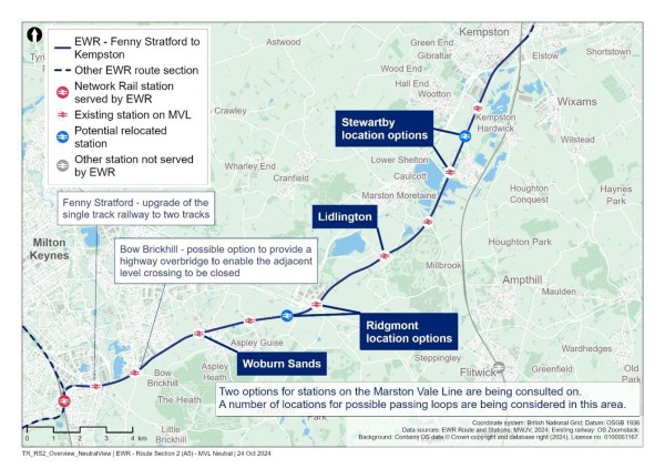
How we have considered the environment when developing our proposals
As we continue to develop our proposals for this section of East West Rail, we are thinking carefully about a number of environmental matters, including:
Landscape and visual
- We will carry out a landscape and visual impact assessment to understand potential impacts, particularly for people using public rights of way and for nearby residential properties. We will incorporate appropriate mitigation in our designs to reduce visual impacts as far as possible.
Biodiversity and nature conservation
- Our assessments will determine what potential impacts will need to be mitigated. Following the mitigation hierarchy we will seek to avoid impacts, and where this is not possible other measures to minimise or rectify impacts will be explored, with compensation measures used as a last resort.
Water resources and flood risk
- Our assessment will determine suitable measures to ensure our works would not deteriorate the water quality and characteristics of at least three surface water catchments, and other water bodies in the area.
Historic environment
- We will undertake an assessment of any significant heritage impacts, and incorporate appropriate mitigation in our designs. This will include considering the potential impacts of works at Lidlington station, and utility works on the settings of the scheduled medieval moated site north of Lidlington, the listed Thrupp End Farmhouse, and the listed buildings associated with the Woburn Estate.
Initial information about potential impacts and mitigation concepts in this route section are provided in Chapter 6 of the Environmental Update Report.
9.2 Stations and train services
9.2.1 Options being considered
Our proposals build on the two alternative options for the stations along the Marston Vale Line that were introduced at the 2021 consultation. This section explains how each of these would operate with the revised train service pattern that is now proposed. As Bedford St Johns station would require relocation under all options, it is not included in this section and is described further in Chapter 10 of this Consultation Document.
Existing Stations Option
The Existing Stations Option would continue the current stopping service between Bletchley and Bedford calling at all nine existing stations. In addition, two Oxford to Cambridge East West Rail trains an hour would call at four of the nine existing stations (Woburn Sands, Ridgmont, Lidlington, Stewartby).
Consolidated Stations Option
The Consolidated Stations Option would involve the nine existing station locations being consolidated into four new, modern and easy-to-access stations at Woburn Sands, Ridgmont, Lidlington and Stewartby. All trains in this option would call at each of the four Marston Vale Line stations, and be able to run through to Cambridge.
We also considered a third ‘hybrid’ option which combines elements of the other options.
Each of these options is described in more detail later in this section.
Whilst our analysis shows that consolidating the Marston Vale Line stations offers many advantages over the other options, we recognise that the existing stations and services are important to some parts of the community. We are therefore presenting the Consolidated Stations Option and Existing Stations Option for further feedback and providing more detail – particularly on the locations of the consolidated stations and what this option would mean for passengers and the local communities.
We want to hear your views on the options, including the benefits of maintaining the existing stations and hourly stopping service compared to the benefits that would occur with a different configuration of stations and services. We will take your feedback into account when deciding which option to take forward.
9.2.2 Existing Stations Option
The Existing Stations Option, referred to as Concept 1a in the Technical Report, would involve the nine Marston Vale Line stations being retained in their existing locations (noting that Bedford St Johns would be relocated as described in Section 10.2.2).
The existing hourly train service between Bletchley and Bedford would be largely unchanged and would stop at all the existing stations. In addition, two faster East West Rail trains an hour between Oxford and Cambridge would call at four of the stations – Woburn Sands, Ridgmont, Lidlington and Stewartby, before continuing to Bedford St Johns and onwards to Cambridge.
Figure 20: Existing Station Option Service Pattern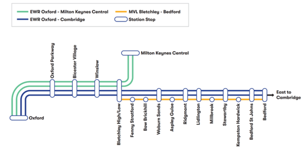
This option represents an evolution of the concept that was presented at the 2021 non-statutory consultation and it includes some important differences. In particular, it no longer involves the relocation of Ridgmont station that was proposed in 2021. In addition, the revised train service pattern would mean that the additional semi-fast services would stop at four of the nine stations rather than just two (Woburn Sands and Ridgmont) as proposed in 2021.
This option would cost less than the Consolidated Stations Option but has a number of drawbacks and would not deliver the full benefits of East West Rail.
Station upgrades
Under this option, minor upgrades to all existing stations would be carried out for safety purposes. More substantial works would be required at Stewartby station. Platform extensions would be required to accommodate longer East West Rail trains at Woburn Sands, Ridgmont, Stewartby and Lidlington, whilst some minor platform extensions might also be required at other stations for safety purposes.
- At Fenny Stratford station, it would be necessary to construct a second platform. These works would affect neighbouring businesses and adjacent gardens north and south of the station. Given the likelihood of further impacts, low level of existing usage and the station’s good connections to local destinations including Bletchley station by other modes, we are not proposing more significant enhancements.
- At Bow Brickhill station, we are proposing safety and accessibility-related enhancements. Located on the south-eastern edge of Milton Keynes, the station currently has an estimated average of 66 users per day. Whilst we recognise the station is in close proximity to residential and business areas, we don’t expect usage of the station to change significantly under this option. Enhancing the station further would also have significant impacts for neighbouring businesses and would constrain options for the overbridge which might replace Bow Brickhill level crossing.
- Aspley Guise, Millbrook and Kempston Hardwick stations, which have an estimated average of 17 users per day, and are located in remote locations. Only safety and accessibility-related enhancements are proposed at these stations. These works would have an impact on residential properties (Aspley Guise and Millbrook), and farms and development land (Kempston Hardwick).
- At Woburn Sands and Lidlington stations we are proposing safety and accessibility-related enhancements. We have considered opportunities for expanding these stations but have concluded there is limited potential for this because of the physical constraints at these sites. Providing widened platforms, enhanced station facilities and sufficient parking would not be possible without impacting the Pristine Business Park, Woburn Sands town centre green space, or neighbouring properties in either village.
- At Ridgmont station, we are proposing safety and accessibility-related enhancements. The station offers opportunities for expansion, although it is anticipated this would result in some impacts to neighbouring businesses.
- A third platform would be required at Stewartby station to accommodate the two proposed services that would operate between Stewartby and Cambridge with this option. Because of this, Stewartby station may need to move from its existing location. Further work is required to confirm this.
Because of the limited nature of the upgrades that are possible at the existing stations, the facilities are likely to be below the standard expected by customers and local residents. These stations would have very limited scope for additional car parking, drop off points, public transport integration, waiting areas etc. The facilities would be of a lower standard compared to other stations on the network which have an equivalent level of passenger usage expected for the East West Rail services. The increased demand for East West Rail services could result in increased on-street parking and traffic around the existing station locations.
Under this option, it is assumed that a turnback siding north of Bedford Midland would need to be provided to support the continued operation of the stopping service.
Train services
Under this option, existing communities could continue to access the train service as they do today from these stations – although passenger use at many of these stations is currently some of the lowest in the country. Two Oxford to Cambridge services an hour – stopping at Woburn Sands, Ridgmont, Lidlington, Stewartby and Bedford St Johns – would complete the journey between Bletchley and Bedford in around 28-29 minutes – a third less than the time taken by today’s stopping service.
The other intermediate stations on the Marston Vale Line would not benefit from these new fast services or direct services to Oxford and Cambridge, but opportunities would exist for people from places like Aspley Guise and Millbrook to use the stopping service to change at the four stations served by the fast services, and reach those further destinations.
Some shorter journeys between intermediate stations on the Marston Vale Line would likely take slightly longer, as the stopping service would need to stop and wait to allow faster services to overtake on some occasions. However, overall end-to-end journeys on the stopping service should be broadly consistent with today because of other improvements aimed at increasing train speeds.
Keeping the hourly stopping service would mean the Marston Vale Line would operate with a combination of fast and stopping services. This would introduce some operational complexity which could increase the risk of disruption and delays for passengers.
The current stopping service on the Marston Vale Line operates with two-car diesel trains. If the Existing Stations Option was selected, we would need to consider what trains would be used in the longer term in line with our wider strategy for powering the trains along the route. Our working assumption is that this would remain a diesel service. It is unlikely that a hybrid battery-electric train option would be adopted for the stopping service upon opening of the full East West Rail services as it would be difficult to justify the further investment required for this given the low expected use of the stopping service.
9.2.3 Consolidated Stations Option
The second option – the Consolidated Stations Option, referred to as Concept 2 in the Technical Report – would involve the nine existing station locations being consolidated into four new stations. All East West Rail services in this section would call at each of the four Marston Vale Line stations, and be able to run through to Cambridge.
Figure 21: Consolidated Station Option Service Pattern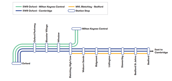
The Consolidated Stations Option requires more investment in the Marston Vale Line but also delivers significant benefits over the alternatives:
- All four stations on the Marston Vale Line would be new and purpose-built to provide modern facilities for customers as well as ample parking, bike storage and public transport interchange. This would avoid the need for passengers to park on roads within the villages.
- The new stations would be more conveniently located to reflect the changes along the Marston Vale Line in recent years, catering to the needs of existing villages and new, growing communities.
- These new locations would be more easily accessible to more people compared to the existing station locations, bringing less traffic through villages and helping ease the pressure on level-crossings, particularly as the demand for East West Rail grows.
- Every train stopping at the new stations would connect all the way to Cambridge – 50% more than would occur with the Existing Stations Option, plus the journey time between Bletchley and Bedford would be 35% quicker than the previous stopping service. This means that more people living on the Marston Vale Line would have more frequent and faster connections to a wider range of places, providing better access to employment, health care facilities, education, and leisure destinations.
- In combination, these new, more accessible and better equipped stations with more frequent services to more destinations are expected to naturally attract some of the few users of smaller intermediate stations if these were to remain open.
- The service pattern is anticipated to be more reliable for customers with this option because it would be more consistent and therefore simpler and easier to operate, resulting in less likelihood of disruption and delays for passengers.
The Consolidated Stations Option would therefore be faster and more reliable for more people. The relatively small number of people who currently use the existing stopping service from some of the existing stations may have a slightly longer journey to reach their new station location compared to the existing ones. In most instances, however, the additional time to reach the new station locations would be more than made up by the time saved from faster services, removing the lack of interchange to travel beyond Bletchley or Bedford, and the increased convenience of more frequent trains to more destinations. This is particularly the case because the consolidated stations would also benefit from better public transport connections, noting that in most cases, the current stations are poorly served by other public transport services. The expected increase in demand at these stations, our commitment to accessibility and emerging approach to door-to-door connectivity would put specific focus on improving the connections to those areas where stations would be consolidated, with consideration of all modes of transport, and we are working on this with local partners.
9.2.4 Four new stations on the Marston Vale Line
The Consolidated Stations Option would mean relocating or rebuilding the following stations along the Marston Vale Line:
- Woburn Sands station.
- Ridgmont station (two location options).
- Lidlington station.
- Stewartby station (two location options).
We want the four new stations on the Marston Vale Line to be easy to use for everyone, with modern, efficient facilities that improve the passenger experience. While there would be similarities in the design of all relocated stations along the Marston Vale Line, each one would have regard to its immediate surroundings. This includes considering current passengers and future growth from proposed housing and employment developments along the line.
Our vision is to provide easy, everyday journeys which bring people and places together. To do this, three of the relocated stations would each have two platforms, and Stewartby would have three platforms. All stations would have public facilities, an accessible bridge between platforms and a car park. The stations would also have provision for electric vehicle charging, cycle parking and public transport interchange. These facilities would provide a step-change in accessibility so all passengers can confidently benefit from the new connections provided by East West Rail.
Figure 22: Indicative illustration of what an East West Rail station could look like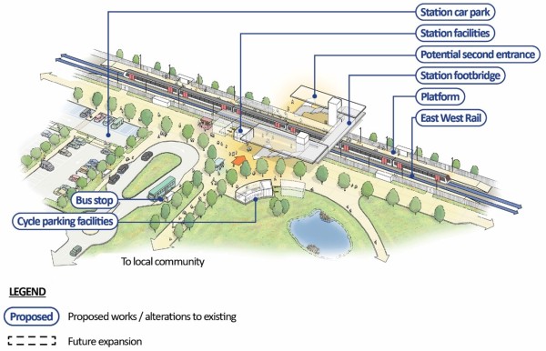
9.2.4.1 A new station at Woburn Sands
During the 2021 consultation, we explained that moving Woburn Sands station would allow us to build a bigger and better station, and this has subsequently been confirmed as outlined in Section 9.2.2 of this Consultation Document. The station would need to be expanded to accommodate the increased number of passengers that would use East West Rail and the longer trains that would carry them. This would not be possible to the same extent in its existing location.
For this reason, a relocated station a short distance to the west of the existing station is considered to offer a better passenger experience and more options for how passengers get to the station, including drop-off and parking facilities and bus stops.
The station and car park would be located to the west of the existing station and to the north of the railway within the area of the South East Milton Keynes Strategic Urban Extension proposal (SEMK). This location would continue to provide easy access for existing residential areas via Newport Road and direct access to the new housing development.
A new road bridge is planned to the west of the proposed station as part of the SEMK development in this area and is therefore not included in our proposals. We will continue to have further discussions with the developer and Milton Keynes City Council as the proposals are progressed.
Figure 23: Map showing the relocated Woburn Sands station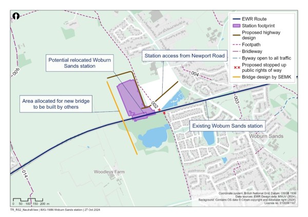
What this means for people using Fenny Stratford and Bow Brickhill stations
Passengers travelling to and from Fenny Stratford and Bow Brickhill stations currently only have one train an hour between Bletchley and Bedford. This would remain the case under the Existing Stations Option, as there would only be an hourly train service available from Fenny Stratford and Bow Brickhill.
Consolidating the stations would mean passengers who use Fenny Stratford station and Bow Brickhill would benefit from a three-fold increase in trains that would be quicker at other stations nearby:
- For passengers currently using Fenny Stratford station, this would mean more frequent and faster direct services from Bletchley: there would be three trains an hour taking just 26 minutes between Bletchley and Bedford, significantly quicker than the current 42 minutes. Fenny Stratford is already well-connected to Bletchley and Milton Keynes stations by bus and less than a 10-minute cycle ride for cyclists.
- For passengers currently using Bow Brickhill station, a relatively small number of people may need to travel further to get to and from the relocated Woburn Sands station (up to 10 minutes longer in a car, for example). The new Woburn Sands station would be serviced by three trains per hour, which represents a three-fold increase in trains and faster journey times to Bedford (fewer than 25 minutes) and Cambridge (under an hour). This would make up for the extra time it may have taken to reach Woburn Sands station. The same time saving would also be the case if travelling onwards towards Oxford. We recognise that some passengers may use Bow Brickhill to get to work, and ways of reducing this impact would be considered as part of our emerging approach to door-to-door connectivity.
- Passengers currently using the existing Woburn Sands station would benefit from more frequent and faster trains from a new station located a short distance further west. Woburn Sands residents living south of the existing station would have to walk up to an additional six minutes to access the station, but would benefit from much faster journeys that would more than make up that time.
9.2.4.2 A new station at Ridgmont
Ridgmont station isn’t currently big enough to cope with the number of passengers anticipated when East West Rail services are introduced. Under the Consolidated Stations Option, Ridgmont station would either be redeveloped in its current location or relocated.
We are considering two options:
- Option 1 would relocate the station to the west of Bedford Road. The station facilities and car parking would be located north of the railway.
- Option 2 would redevelop the existing station on its current site. The station facilities and car parking would be located north and south of the railway.
We are seeking your feedback on these two options for Ridgmont station as part of this consultation.
Option 1 – relocation of Ridgmont station to the west of Bedford Road
This option would move the station west of Bedford Road with the station and car park located to the north of the railway. New platforms would be constructed north and south of the railway with a new accessible footbridge providing access across the tracks.
Since this area is currently agricultural land, relocating the station to this site would have fewer impacts on existing infrastructure and businesses.
The main station access would be from Bedford Road, where a new junction and access road would be built. Bedford Road may be widened for a short distance on the approach to the junction to allow vehicles to turn right into the station without blocking other traffic. This proposed location would mean that people who currently use Ridgmont station would probably have to travel a bit further to get to the station.
The Bedford Borough Council Local Plan 2030 includes a proposal for a waterway between Bedford and Milton Keynes. This would run alongside the railway in this area. If Option 1 for the station is built, the proposed route of the waterway would need to be diverted around the station area.
Figure 24: Map showing Ridgmont station Option 1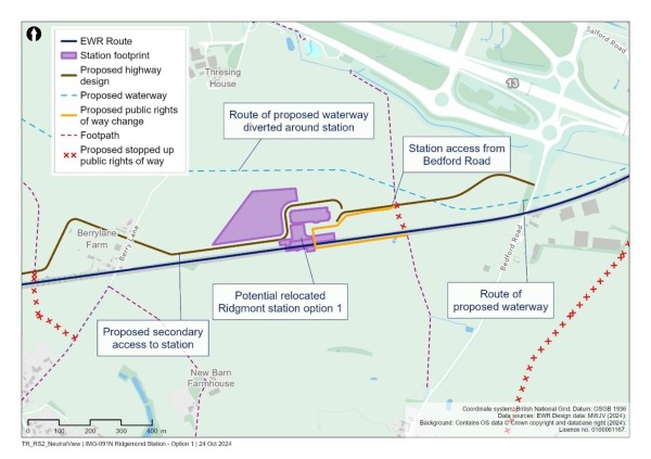
Option 2 – Redevelopment of the current station
Option 2 would provide a new expanded station in its current location, with a new car park built south of the railway. Additional car parking may also be provided north of the railway between Station Road and the A507 as demand increases.
The two station platforms would be rebuilt to accommodate longer East West Rail trains, with a new accessible footbridge providing access across the tracks and the proposed waterway.
Building the longer platforms would mean that the level crossing on Station Road would need to be closed. More information on the proposals for level crossings can be found in section 5.6 of this Consultation Document.
Figure 25: Map showing Ridgmont station Option 2 under the Consolidated Stations Option
What this means for passengers currently using Aspley Guise station
Aspley Guise station is remote and the least used station on the line, with around 30 entries and exits from the station per day. It is a half-mile walk away from the nearby village, and the station is less convenient for others who may be travelling from further away.
Under the Consolidated Stations Option, a potentially relocated Ridgmont station would be centrally located between Ridgmont and Aspley Guise and easily accessible from the M1. This provides an opportunity to serve both communities without the need for multiple stations.
For communities in Aspley Guise, the new relocated station would be less than 10 minutes away by car, 15 minutes by bicycle and 20-30 minutes on foot from Aspley Guise village, depending on new pedestrian and cycle routes. It would also offer a new station with more parking, three times more trains and more direct and faster routes to Bedford, Cambridge, Bletchley and Oxford.
The benefits associated with a relocated station could not be achieved using the existing and underused Aspley Guise station. However, we recognise that the proposed relocated station may be less accessible for the relatively small number of people who access Aspley Guise station from the village, so we are considering ways to maximise the station’s accessibility as part of our emerging approach to door-to-door connectivity.
9.2.4.3 A new station at Lidlington
In 2021, we explained that moving Lidlington station would allow us to build a larger station with better facilities that could serve more people from the local area. Lidlington station currently isn’t big enough to support the number of passengers expected when East West Rail services are running. Moving Lidlington station would mean we could build a better station with improved passenger facilities to make journeys easier.
We are proposing to move Lidlington station east of its current location into an area of land on the eastern edge of the village. This location is still close to existing residents and businesses but allows us to offer better connectivity for existing and new communities without impacts on existing properties.
The location would also be part of the Marston Valley development, so a station here would help reduce traffic trying to reach a station location elsewhere in the village. The Marston Valley development land is set aside in the Central Bedfordshire Local Plan 2015 to 2035.
Access to the station would be from the north via a new link which we would build between Station Road and Marston Road. Some parking north of the railway would be provided for those travelling by car to the new station. The new road would avoid the need for people to drive through Lidington village to access the station and reduce any potential congestion that the new station might cause.
Figure 26: Map showing the relocated Lidlington station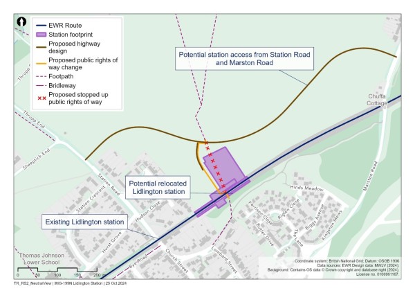
What this means for passengers currently using Millbrook station
Millbrook station is over 1km from communities Marston Moretaine (a 20-minute walk) and Millbrook (a 24-minute walk). It is one of the least used stations on the line with an estimated 17 users a day on average. Its isolated location means that the low number of current users likely need a means of transport to get to the station already, which presents challenges given a lack of parking and public transport connectivity.
The station’s location on the route is between Lidlington and Stewartby stations. Under the Consolidated Stations Option, the relatively small number of passengers currently using Millbrook station would likely use the new station at Lidlington, approximately a 5-minute drive from the current Millbrook station. This journey would be largely comparable to the journey to Millbrook station today. Those travelling east may prefer to use the new station at Stewartby (see section 9.2.4.4), which would be around a 10-minute drive.
9.2.4.4 A new station at Stewartby
The existing Stewartby station is close to Stewartby village, Kimberley Sixth Form College, and two existing road level crossings. The current station isn’t big enough to support the expected increase in the number of passengers using the station. Station improvements would also need to be made to accommodate longer trains.
Our latest train service proposals involve some train services to and from Cambridge turning around at Stewartby, instead of Bedford. This would provide better connectivity to Bedford Hospital between Stewartby and Cambridge. Stewartby station would have three platforms to accommodate this service.
In the 2021 non-statutory consultation, we proposed moving Stewartby station close to Broadmead Road. We have continued to work on options for where Stewartby station could be relocated or whether we can improve the station in its existing location.
This work has led to two options for Stewartby station:
- Option 1 – move the station slightly north of its current location.
- Option 2 – move the station to the north of Broadmead Road.
We know that Stewartby is growing, with proposed housing and employment sites identified in the Bedford Borough Council Local Plan 2030. An improved station would help people get to and from the new homes and jobs that are being created.
We are also aware of proposals by Universal Destinations & Experiences to build a new theme park north of Stewartby. We are discussing the theme park proposals with developers and Bedford Borough Council and we will consider how this may impact our designs.
We encourage you to tell us what you think of the two options for Stewartby station through the feedback form.
Option 1 – move the station slightly north of its current location
Option 1 would relocate the station 300m north of the existing location, with the station and car park located to the east of the railway. Three new platforms would be constructed: a side platform and an island with two platforms.
The main station access would be from Green Lane. Since the station would be near its current location, people using the station would still be able to use existing roads and paths and get to Stewartby village and Kimberley Sixth Form College. The journey from the new station would be approximately 200m longer than it is today.
The station would be on the former Stewartby Brickworks site on the southern edge of the proposed future developments. As this location is more than 4km (2.5 miles) from the northern end of the development area it would be less accessible for proposed developments near Kempston Hardwick than Option 2.
Figure 27: Map showing Stewartby Option 1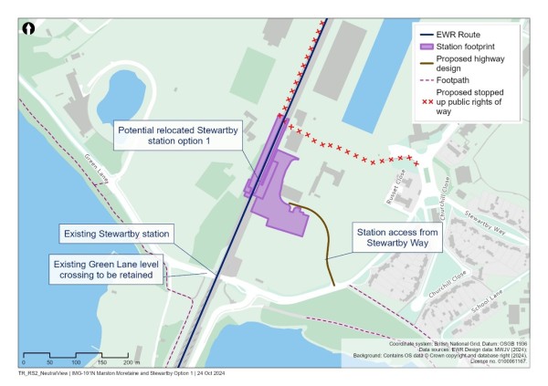
Option 2 – move the station to the north of Broadmead Road
Option 2 would relocate the station around 1km north, to the north of Broadmead Road. Three new platforms would be constructed: a side platform and an island with two platforms. The station and car park would be located east of the railway. The main access to the station would be from Broadmead Road.
This station location would be easily accessible to people who will live in the Stewartby Brickworks development as well as other developments around Kempston Hardwick.
This location would, however, move the station further from Kimberley Sixth Form College and Stewartby village. We are considering the benefits of both locations with a focus on potential implications for accessibility from Stewartby and Kimberley College. If this option was taken forward, further consideration would be given to maintaining connectivity for existing station users through new and improved walking and cycling links to the station.
Figure 28: Map showing Stewartby Option 2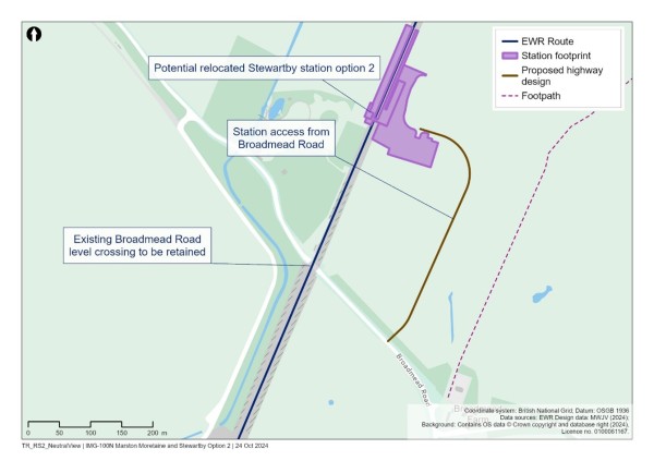
What this means for people currently using Kempston Hardwick station
Kempston Hardwick station is one of the least used on the line, with only around 34 entries and exits per day. This is likely due to its remote location which means people are likely to have another means of transport to get to the station.
Consequently, accessing Stewartby station would have little impact on these users. In the case of Wootton residents travelling to Kempston Hardwick, for example, this is currently a five-minute car journey which would also be similar with a relocated Stewartby station. It would also mean that, rather than catching a bus or driving straight to Bedford for a direct connection to Cambridge, adding more time to their journey (an approximately 15-minute drive plus the waiting time to catch a train to Cambridge), they would now be able to head to Stewartby and access three trains an hour direct to Cambridge.
9.2.5 Hybrid Stations Option
In considering the two options, we also examined whether there might be a hybrid option, referred to as Concept 1b in the Technical Report, which would provide relocated stations but also retain the slower, stopping service to call at the remaining existing stations.
This would be the most expensive option, requiring additional investment to be spent at stations that have fewer than an estimated 40 customers a day. Those stations would be likely to get even fewer customers under this option because people would choose instead to use the upgraded stations which would have more train services. The four upgraded stations would have fewer services to Cambridge than under the Consolidated Stations Option. As well as costing more money, like the Existing Stations Option this hybrid option would not deliver the full benefits of East West Rail. It would constrain the capacity, frequency and speed of train services for most Marston Vale Line residents to desired destinations like Cambridge, and require a more complex service pattern with greater risk of potential for disruption and delays for passengers. For these reasons, the Hybrid Stations Option is not currently proposed to be taken forward.
9.2.6 Give us your views on the options
The analysis we have carried out shows that the Consolidated Stations Option would bring significant benefits for passengers, existing villages and the growing new communities along the line. This option is most consistent with our commitment to enabling greater economic opportunity in the area, delivering more frequent, faster and more reliable services for more people. However, we recognise that the existing stations and services are important to some parts of the community.
A decision on the Marston Vale Line stations has not yet been taken. Through this consultation, we are asking for your feedback on the Existing Stations Option and the Consolidated Stations Option including the benefits of maintaining the existing stations and the benefits that would come from an upgraded configuration of stations and services. We will take this feedback into account before we confirm our preferred approach.
Given that significant investment in the Marston Vale Line would be required to consolidate and enhance the stations, we will continue to test the value of the proposed consolidated station locations. If this option is taken forward, we will carefully consider factors such as affordability to ensure they have a robust business case, before confirming the final proposals.
9.3 Fenny Stratford twin-tracking
Under all options for the Marston Vale Line, we would need to lay an additional section of track to the existing railway between Bletchley station and to the east of the A5 trunk road near Fenny Stratford.
The existing section of single track would not be able to cope with the additional East West Rail trains between Oxford and Cambridge, so a second track would need to be added. Because a second track has previously existed on this section, it should be possible to fit the additional track within the existing railway boundary. However, there might be some areas where we need more land to meet current design standards or to repair or improve the existing embankment.
This work would temporarily impact the parking for some commercial properties on Watling Street and Simpson Road north of the railway. We may also need to acquire two commercial properties on Tavistock Street to the south of the railway. We recognise the impact this would have and will be working with affected businesses to understand and mitigate these impacts where possible. As the designs are further developed we will seek to agree measures to reduce the impacts of our proposals where possible and to seek to enter into agreements with property owners where acquisition cannot be avoided.
Four bridges currently carry the existing railway over the Grand Union Canal, River Ouzel and key local roads such as the A5 and Saxon Street. However, these bridges were built to carry only one track, so we would need to make changes to them.
To accommodate two tracks, the bridge that carries the railway over Saxon Street would be demolished and replaced, the current level crossing on Simpson Road would be widened, and we would also widen the embankments along the railway. Consideration is being given to delivering some of these works early to enable a new Oxford to Bedford hourly service from 2030.
East of the current Fenny Stratford station, a small number of modifications to the existing Grand Union Canal bridge would be needed to allow for the additional track. New bridges would be required to enable the extra track to be built over the River Ouzel and the A5.
To make sure this work is done safely and efficiently, we would have to temporarily close some sections of the railway and highway. Work would mainly be done during normal working hours to reduce the noise and disruption to people living nearby.
Demolition works are currently expected to affect a small number of commercial properties along the route of the proposed additional tracks.
Figure 29: Map showing the extent of twin-tracking in Fenny Stratford![]()
9.4 Our approach to level crossings on the Marston Vale Line
There are 30 level crossings on the Marston Vale Line between Fenny Stratford and Bedford. Some of these are for vehicles and others are public rights of way crossings for pedestrians, cyclists and others. There are also six private crossings that landowners use to cross between their land on each side of the railway.
In the 2021 non-statutory consultation we proposed closing many of these level crossings. We received a lot of feedback about the level crossings during community conversations and in response to the consultation. This feedback has been considered when developing our proposals. At the route update announcement in 2023 we indicated it may be possible for more of the crossings to remain open.
Since the route update announcement, we have assessed each level crossing to understand safety risks and the impact that more trains travelling on the Marston Vale Line would have on traffic and community connectivity. This work, and feedback received, has informed the proposals we are now presenting in this consultation.
Where level crossings are proposed to be closed, we have sought to minimise the length of the diversions and any potential inconvenience to users.
In addition, we are progressing plans to accelerate Connection Stage 2, to enable an East West Rail service to run between Oxford and Bedford from 2030. Planning consent for the necessary works to level crossings was obtained by Network Rail in 2020 a Transport and Works Act order (TWAO). The level crossings where work will be accelerated are highlighted by the inclusion of the following text ‘The closure of this crossing was authorised by the TWAO made in 2020’.
9.4.1 What we are proposing and why
East West Rail would increase the number of trains along this part of the railway to three trains per hour in each direction, plus a fourth train from Stewartby to Cambridge. As well as being more frequent, trains would be going faster than the current train service. These changes raise the level of safety risk at the level crossings.
This means we have had to consider whether we can upgrade the level crossings to make them safe, or whether closing the level crossing is necessary.
For each crossing, a risk assessment has been carried out which has considered how many people would use the crossing and the number of trains that would pass over the crossing during the course of the day. The assessments have followed the Network Rail standard method for the national rail network called the All Level Crossing Risk Model (ALCRM). This was used to help decide whether a level crossing could stay open (with changes if necessary) or needed to close.
When deciding on the best solution for road level crossings, we considered future housing growth, commercial developments and predicted growth in traffic on local roads. We also considered the increased delays experienced by people crossing the railway due to the barriers at level crossings needing to be down more often. We will carry out further modelling of the future traffic around the level crossings before making our final decisions.
Our proposals include diverting some public footpaths to a safer place to cross the railway. We have sought to make these as short as possible to reduce inconvenience. Sometimes the proposed diversions mean we would have to create new sections of public rights of way.
Table 2 provides a summary of our proposals for the level crossings in this area. More detail for each proposal is provided in the sections following the table. The different station options for the Marston Vale Line have been considered as part of EWR Co’s assessments of the level crossings. Based on work to date, the proposals to keep a crossing open or closed are expected to remain the same under all station options, but some diversion routes may vary depending on which station option is selected.
Table 2: Summary of Marston Vale Line level crossing proposals
|
Level crossing name |
Current type of crossing |
Proposal at route update announcement 2023 |
Current proposal |
|
Fenny Stratford (Simpson Road) |
Highway |
Retain as a CCTV crossing. |
Retain as a CCTV crossing.
Crossing would need to be widened to accommodate the new twin tracking in this area. |
|
Bow Brickhill (V10 Brickhill Street) |
Highway |
Retain as a CCTV crossing. |
Retain as a CCTV crossing, or if crossing cannot be retained due to traffic impacts close and replace with new bridge to the east of the crossing. |
|
Browns Wood |
Footpath |
Close and divert to Pony crossing. |
Close and divert to Pony crossing.
Diversion via new footpath south of the railway. |
|
Pony |
Bridleway |
Retain and upgrade to miniature stop light crossing. |
Retain and upgrade to miniature stop light crossing. |
|
Woodleys Farm |
Occupation |
Close and extinguish crossing rights. |
Close and extinguish crossing rights.
Alternative routes for authorised users are available.
The closure of this crossing was authorised by the TWAO made in 2020. |
|
Fisherman’s Path |
Footpath |
Close with no replacement. |
Close and divert users to Woburn Sands level crossing.
Diversion route via Drayhorse Crescent south of the railway and the proposed new station access road north of the railway. Alternative diversion route via new Woburn Sands station footbridge may be possible.
The closure of this crossing was authorised by the TWAO made in 2020. |
|
Woburn Sands (Newport Road/Station Road) |
Highway |
Retain as a CCTV crossing. |
Retain as a CCTV crossing. |
|
Mill Farm |
Footpath |
Close and divert to Woburn Sands level crossing. |
Close and divert to Woburn Sands level crossing.
Diversion via existing footpaths. |
|
Sewage Farm |
Footpath |
Close and divert footpath. |
Close and divert footpath.
A new section of footpath is proposed between Mill Farm and Sewage Farm crossings south of the railway to provide a circular walking route. Footpath north of the railway would be extinguished as there is no onward route. |
|
Aspley Guise (Station Road) |
Highway |
Retain as a CCTV crossing. |
Retain as a CCTV crossing. |
|
Old Manor Farm |
Footpath |
Close and divert footpath to Aspley Guise level crossing |
Close and divert users to Aspley Guise level crossing.
Diversion route via Berry Lane south of the railway and a proposed new access track north of the railway. |
|
Berry Lane |
Occupation |
Close and divert via access tracks. |
Close and diversion via roads/access tracks.
Diversion would be to Aspley Guise level crossing. Diversion route via existing roads south of the railway and a proposed new access tracks north of the railway.
The closure of this crossing was authorised by the TWAO made in 2020. |
|
Long Leys |
Accommodation |
Close and diversion via access tracks. |
Close crossing and divert users to Aspley Guise level crossing.
Diversion route via Berry Lane south of the railway and proposed new access tracks north of the railway.
The closure of this crossing was authorised by the TWAO made in 2020. |
|
Husborne Crawley 6 |
Footpath |
Close and diversion via access tracks. |
Close and divert.
Close and divert to Ridgmont station footbridge if Ridgmont station is relocated (Option 1).
Close and divert via Bedford Road if Ridgmont station remains in its current location (Option 2). |
|
Matey Boys |
Accommodation |
Close and diversion via access tracks. |
Close and extinguish crossing rights.
Alternative access available via Bedford Road.
The closure of this crossing was authorised by the TWAO made in 2020. |
|
Husborne Crawley 10 |
Footpath |
Close crossing and extinguish footpath. |
Close crossing and divert users to Ridgmont level crossing or station footbridge depending on which Ridgmont station option is chosen.
Diversion route via public footway along Mill Road.
The closure of this crossing was authorised by the TWAO made in 2020. |
|
Ridgmont (Station Road) |
Highway |
Retain as a CCTV crossing. |
Retain as a CCTV crossing if Ridgmont station is relocated (Option 1).
Close crossing if Ridgmont station is located at existing station location (Option 2).
Vehicles diverted via A507 and pedestrians to use new station footbridge. |
|
Broughton End |
Footpath |
Close and divert to Forty Steps. |
Close and divert users to Playing Field level crossing.
Diversion via existing footpaths. |
|
Forty Steps |
Footpath |
Retain and upgrade to miniature stop light crossing. |
Close and divert users to Playing Field level crossing.
Diversion route via existing footpaths south of the railway and a new footpath north of the railway. |
|
Playing Field |
Footpath |
Close and divert to Forty Steps. |
Retain and upgrade to miniature stop light crossing. |
|
Lidlington (Station Road) |
Highway |
Retain as a CCTV crossing. |
Retain as a CCTV crossing. |
|
Pilling Farm South |
Footpath |
Close and divert footpath. |
Close and divert footpath.
Diversion to Station Road or alternate diversion route via proposed Lidlington station footbridge.
The closure of this crossing was approved by the TWAO made in 2020. |
|
Marston (Marston Road) |
Highway |
Upgrade to a manually controlled barriers monitored by obstacle detection (MCB-OD) crossing. |
Assumed to be closed by Network Rail with new overbridge.
If not closed, would be upgraded to full barrier crossing.
The closure of this crossing was authorised by the TWAO made in 2020. |
|
Millbrook (Station Lane) |
Highway |
Retain as a CCTV crossing. |
Retain as a CCTV crossing. |
|
Green Lane |
Highway |
Retain as a CCTV crossing. |
Retain as a CCTV crossing. |
|
Stewartby Brickworks |
Occupation |
Close with no replacement. |
Close with no replacement.
Footpath to be extinguished north and south of railway.
The closure of this crossing was authorised by the TWAO made in 2020. |
|
Wootton Broadmead (Broadmead Road) |
Highway |
Retain as a CCTV crossing. |
Retain as a CCTV crossing. |
|
Wootton Village |
Footpath |
Close and divert to Kempston Hardwick crossing. |
Close and divert to Kempston Hardwick crossing.
Diversion via new footpaths east and west of the railway. |
|
Kempston Hardwick (Manor Road) |
Highway |
Upgrade to a manually controlled barriers monitored by obstacle detection crossing. |
Assumed to be closed by Network Rail with new overbridge.
If not closed, would be upgraded to full barrier crossing.
The closure of this crossing was authorised by the TWAO made in 2020. |
|
Woburn Road |
Footpath |
Close with no replacement. |
Assumed to be closed by Network Rail with new footbridge.
If not closed, would be upgraded to miniature stop light crossing.
The closure of this crossing was authorised by the TWAO made in 2020. |
9.4.2 Fenny Stratford level crossing
Fenny Stratford highway level crossing is located on Simpson Road and would remain open. It would be widened to accommodate the second track proposed for this location.
Figure 30: Map showing Fenny Stratford level crossing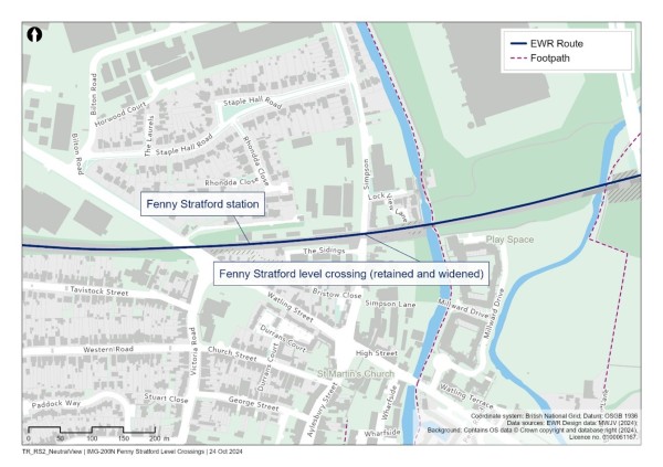
9.4.3 Bow Brickhill level crossing
This highway level crossing sits on V10 Brickhill Street. Currently, one passenger train an hour in each direction and a small number of freight trains pass over Bow Brickhill level crossing every day. When the barrier goes down on the level crossing for these trains it causes traffic queues to form. East West Rail would introduce three passenger trains an hour in each direction over this crossing which would mean the barriers would go down more often and the queues would get longer.
Ongoing traffic modelling has not yet concluded whether Bow Brickhill level crossing can be kept open. The traffic modelling will test the effects of the increased barrier downtime on the local roads and whether increased delays experienced may be too severe to keep the crossing open. If the assessment work concludes the crossing would need to close, we propose to construct a new road bridge to replace the crossing. This would be built east of the crossing. A new connection to the south of the railway would connect Station Road and Brickhill Street. To the north of the railway there would be a new connection to Brickhill Street, Bradbourne Drive, and Caldecotte Lake Drive.
Figure 31: Indicative illustration of possible Bow Brickhill overbridge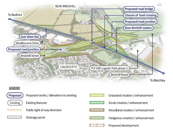
Browns Wood and Pony level crossings
To the east of Caldecotte, there are two crossings known as Browns Wood and Pony. Browns Wood is a footpath level crossing accessible only by pedestrians, while Pony is a public bridleway level crossing that walkers, cyclists and horse riders can use. We are proposing to upgrade Pony level crossing to include miniature stop lights which indicate to users whether it is safe to cross. We would also upgrade the crossing approaches to improve accessibility and overall safety.
Browns Wood level crossing would be closed. A new section of public footpath would be created on the south side of the railway from Browns Wood to Pony level crossing allowing walkers to stay on the footpath and cross at Pony.
Figure 32: Map showing Browns Wood and Pony level crossings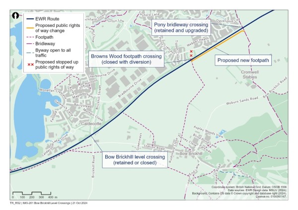
9.4.4 Woburn Sands level crossings
On the west side of Woburn Sands, Woodleys Farm, a private track, would be closed. Ongoing access will be discussed with the relevant landowners. Fisherman’s Path, a footpath crossing, would close and divert users to Woburn Sands level crossing. This diversion route would be via Drayhorse Crescent south of the railway and the proposed new station access road north of the railway. An alternative diversion route via the new Woburn Sands station footbridge may be possible. Depending on station arrangements, walkers on the footpath could also use the new Woburn Sands station footbridge.
The existing Woburn Sands road level crossing at Station Road/Newport Road would remain open.
Mill Farm and Sewage Farm level crossings are public footpath crossings located to the east of Woburn Sands. These crossings would be closed with users diverted to Woburn Sands level crossing using existing routes. We would build a section of new footpath between Mill Farm and Sewage Farm crossings to the south of the railway, creating a circular walking route with adequate access for the farms to use.
Figure 33: Map showing Woburn Sands level crossings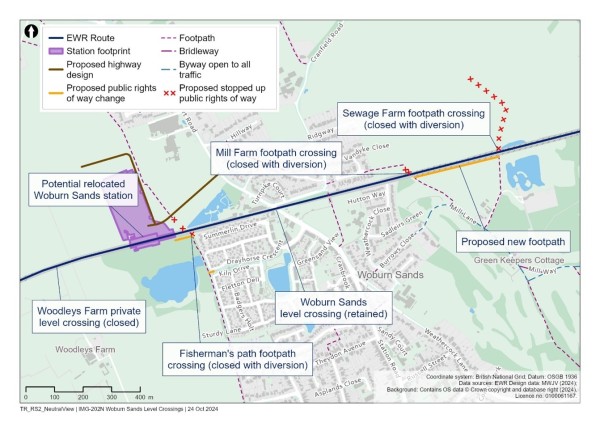
9.4.5 Aspley Guise level crossings
At Aspley Guise we are proposing to keep the Station Road level crossing open to all users. Old Manor Farm footpath level crossing to the east of Aspley Guise would be closed. Users would be diverted to the Aspley Guise (Station Road) crossing along a new access track and footpath that would be built on the north side of the railway.
Berry Lane level crossing, a private crossing located east of Old Manor Farm, would be closed and users diverted to Aspley Guise (Station Road) level crossing using the access track on the north side of the railway.
Long Leys level crossing is a private farm crossing only accessible to authorised users which is proposed to be closed. Users are diverted to Aspley Guise (Station Road) level crossing using the access track and footpath on the north side of the railway and via Berry Lane south of the railway.
Figure 34: Map showing Aspley Guise level crossings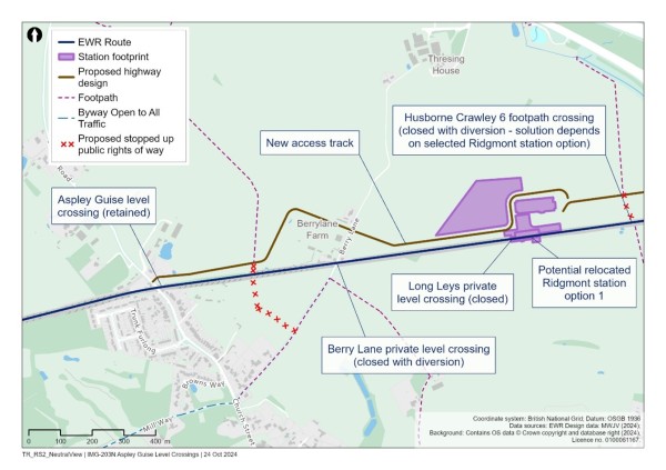
9.4.6 Husborne Crawley and Ridgmont level crossings
Several crossings are located close to the two possible sites for Ridgmont station.
If Ridgmont station Option 1 is chosen (west of the M1):
- Husborne Crawley 6 footpath level crossing would close, with users diverted to the station footbridge.
- Husborne Crawley 10 footpath level crossing would close, with users diverted to Ridgmont level crossing on Station Road via Mill Road.
- The Ridgmont (Station Road) level crossing would remain open.
If Ridgmont station Option 2 is chosen (the existing location east of the M1):
- Husborne Crawley 6 footpath level crossing would be closed, with users diverted via Bedford Road.
- Husborne Crawley 10 footpath level crossing would close, with users diverted to Ridgmont Station footbridge via Mill Road.
- The Ridgmont (Station Road) level crossing would be closed. Vehicles would be diverted via the A507 and pedestrians, cyclists and other users would be diverted to the new station footbridge.
Matey Boys level crossing is a private farm crossing only accessible to authorised users. The crossing is proposed to be closed. The fields to the north and south of the railway could be accessed via Bedford Road.
Figure 35: Map showing Husborne Crawley and Ridgmont level crossings
9.4.7 Lidlington level crossings
The Broughton End footpath level crossing and the neighbouring Forty Steps footpath level crossing would both be closed. Users of these crossings would be diverted to the Playing Field footpath level crossing. A new section of public footpath would be created on the north side of the line between Playing Field and Forty Steps with existing footpaths used between Forty Steps and Boughton End. Footpaths already exist on the south side of the line and connect all three crossings.
Playing Field level crossing would remain open, with a miniature stop light system introduced to improve user safety.
The existing road level crossing on Station Road/Church Street in Lidlington would stay open.
Piling Farm level crossing is a public footpath crossing located east of Lidlington. If Lidlington station were to remain in place, this level crossing would be closed and diverted to Station Road, although Lidlington station’s new footbridge would offer an additional option. If Lidlington station were relocated, this would provide an accessible footbridge within easy reach of the footpath so we would close the level crossing and divert users to this footbridge.
Network Rail has plans to construct a new bridge at Marston Road which means the level crossing could close. If the bridge is not built, we would keep the level crossing on Marston Road open and upgrade it to a full barrier crossing.
Figure 36: Map showing Lidlington level crossings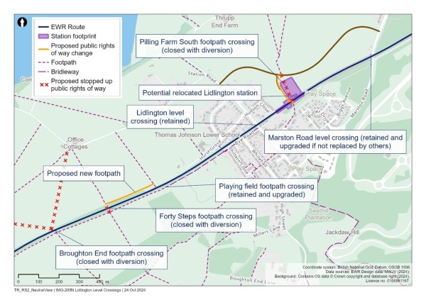
9.4.8 Millbrook (Station Lane) level crossing
The Millbrook level crossing would be kept open.
Figure 37: Map showing Millbrook level crossing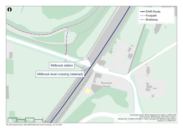
9.4.9 Stewartby level crossings
Green Lane level crossing would be kept open.
The footpath level crossing at Stewartby Brickworks would be closed as the footpath to the west of the railway leads to the old brickworks site. However, a new bridge crossing may be provided in future by the developers of the Brickworks site.
The level crossing at Wootton Broadmead (Broadmead Road) would remain open.
Figure 38: Map showing Stewartby level crossings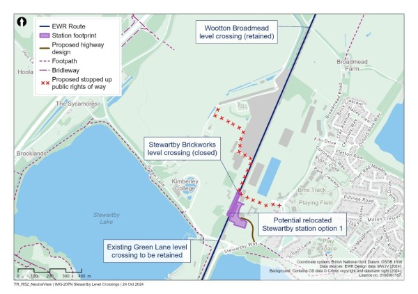
9.4.10 Kempston Hardwick level crossings
The footpath level crossing at Wootton Village would be closed. We would divert users via new footpaths east and west of the railway to the Kempston Hardwick level crossing.
Network Rail has plans to construct a new bridge at Manor Road, which means the Kempston Hardwick level crossing could close. If this does not happen and the bridge is not built, we would keep the level crossing on Manor Road open and upgrade it to a full barrier crossing.
The Woburn Road footpath level crossing further north near the A421 is on a public footpath and is currently used by cyclists and pedestrians to get to Woburn Road Industrial Estate. Network Rail plans to construct a new footbridge to cross the railway here which means the level crossing could close. If the bridge is not built by Network Rail, this level crossing would stay open and be upgraded by the introduction of miniature stop lights to improve safety by warning users about approaching trains.
Figure 39: Map showing Kempston Hardwick level crossings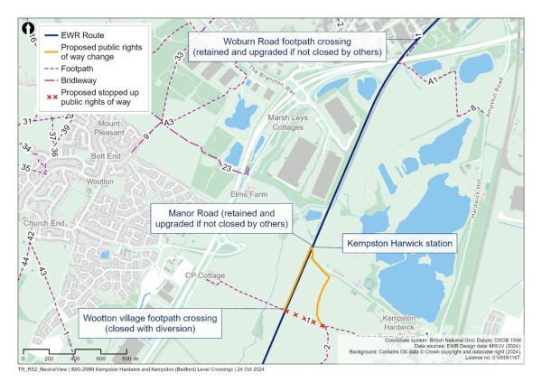
9.4.11 Developing our proposals for level crossings
We will continue to refine our designs for level crossings and undertake more surveys and modelling so that we fully understand the impacts and how these would be best mitigated. This work will help us to understand the impact that more trains, new bridges, and the proposed diversions would have on local traffic and journeys taken by drivers, pedestrians, cyclists and other users of the crossings. We will continue to develop our proposals in line with our approach to accessibility and inclusion in design development which will include assessing our designs for level crossings through the Equality Impact Assessment process.
We will also continue to look for ways to reduce the length of any proposed diversions. When planning to close private level crossings we will continue to talk with the affected landowners about how this would impact them and what diversions or alternatives might be suitable.
You can tell us what you think of our proposals for level crossings through the feedback form. We would like to know whether our proposals would have significant impacts on how you travel and hear suggestions on how we can keep communities connected.
9.5 Passing loops between Ridgmont and Stewartby
There are several options between Ridgmont and Stewartby where we could build passing loops. There are three westbound loop options and three eastbound options. Only one loop is required in each direction. The six options are as follows:
Two passing loop options are proposed in the vicinity of Ridgmont station:
- North of the railway, between Berry Lane level crossing and Bedford Road overbridge.
- South of the railway, between Berry Lane level crossing and Bedford Road overbridge.
Four passing loop options are proposed in the vicinity of Stewartby station:
- West of the railway, south of Green Lane.
- East of the railway, south of Broadmead Road and opposite the former brickworks sidings.
- East of the railway, north of Broadmead Road.
- West of the railway, north of Broadmead Road.
Figure 40: Map showing potential location of loops at Ridgmont and Stewartby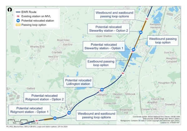
The location of the passing loops would be influenced by the station options selected for both Ridgmont and Stewartby, as the proposals overlap. There are therefore multiple potential combinations for the passing loop locations that could be progressed based on which combination of the Ridgmont and Stewartby station options are selected. Once the station locations are confirmed for Ridgmont and Stewartby, the passing loop options will be further assessed in order to select the preferred solution.
If you have comments on the proposed location of the passing loops, please let us know on your feedback form.
9.6 Share your feedback
We would like to hear your feedback on our proposals for the Fenny Stratford to Kempston route section. We are particularly interested in your views on:
- Which option you prefer for the Marston Vale Line stations (Existing Stations Option or Consolidated Stations Option).
- If the Consolidated Stations Option is taken forward, which of our two proposals for Ridgmont station you prefer and why.
- If the Consolidated Stations Option is taken forward, which of our two proposals for Stewartby station you prefer and why.
- Issues and opportunities we should consider as we develop our proposals for changes to level crossings, including any suggestions on how we can help keep communities connected.
- Issues and opportunities we should consider as we develop our proposals for passing loops near Ridgmont and Stewartby.
You can find details of how to respond to our consultation in the Have your say section of this Consultation Document.
10. Route section – Bedford – improvements to the existing railway and a new section of railway
This chapter explains our proposals for the section of the route serving Bedford, including South of Bedford and Bedford St Johns, Bedford station and the section north of Bedford station. This section of the route would be approximately 5.4km (3.4 miles) long, extending north from Ampthill Road in Kempston to Clapham Road south-east of Clapham village, next to the River Great Ouse.
This chapter covers:
- An overview of what we are proposing and why – including how proposals have developed since last year’s route update announcement.
- How we have considered the environment when developing our proposals.
- Specific proposals around:
- South Bedford and Bedford St Johns.
- Major improvements at Bedford station.
- The section of tracks north of Bedford.
- How to share your feedback using the feedback form.
10.1 What we are proposing and why
Bedford station is already an important transport hub for the region, providing easy connections to regional rail services. Introducing East West Rail services would strengthen the hub, bringing two modern and accessible stations to Bedford.
A multi-million pound make-over of Bedford station would contribute to the regeneration of the area immediately around the station, as well as better connecting it to the centre of Bedford. A brand-new station serving Bedford Hospital between Ampthill Road and Cauldwell Street would replace the existing Bedford St Johns station, providing a better location that’s more convenient for patients, hospital staff and visitors.
How proposals for Bedford have developed
Following feedback from the non-statutory consultation in 2021, we looked again at alignments that would pass to the south of the town or re-use parts of the former alignment of the closed Varsity Line. We identified that these alternatives would have significant environmental impacts and would cause loss of public open space. In response to consultation feedback, we also carried out further work to test whether we could run East West Rail services on the existing Midland Main Line without building additional tracks north of Bedford station. This work showed that we do need two additional tracks to make sure East West Rail could provide a reliable service which does not conflict with other trains.
At the route update announcement in 2023, we therefore explained that the preferred alignment – passing through Bedford station and to the north of the town along the Midland Main Line – remains the best option for Bedford, maximising the benefits for the town.
Work we have done since the route update announcement
Since sharing our proposals in the route update announcement in May 2023, we have developed our design based on feedback from the 2021 public non-statutory consultation as well as continuing environmental, economic and technical studies. These proposals are key to supporting local aspirations for more jobs, prosperity and growth in and around Bedford.
Here’s what we are proposing for this section of the route, and why:
- Relocating Bedford St Johns station to the west to better serve Bedford Hospital and to improve the alignment of the railway into Bedford station so that trains can travel at the speeds required to run the proposed East West Rail timetable.
- Building a new two-track railway to the north of Sandhurst Road that would replace the existing single track Marston Vale Line into Bedford station – again to help achieve the East West Rail timetable.
- We are moving Jowett sidings to Cauldwell Walk, making space for the railway tracks as they approach Bedford station.
- At Bedford station, we are considering a range of work including rebuilding the station building, creating a new station plaza, constructing footbridges and two new platforms (reduced from three shown in previous proposals), and providing replacement car parking, all to give passengers the best possible experience.
- North of Bedford, we are planning to construct an additional two tracks alongside the Midland Main Line to make sure East West Rail services can run reliably without conflicting with other trains. We are also proposing to construct a new 1.1km long viaduct over the River Great Ouse and Paula Radcliffe Way.
- Works to roads in the area to enable the railway to be built and operated, including the realignment of Ampthill Road, Cauldwell Street, Ford End Road, Bromham Road and A6 Great Ouse Way.
- Constructing balancing ponds along the route to manage flood risk.
- Diverting some utilities, including overhead power lines to avoid the new viaduct.
Figure 41: Map showing Bedford route section
How we have considered the environment when developing our proposals
As we continue to develop our proposals for this section of East West Rail, we are thinking carefully about a number of environmental matters, including:
Noise
- Noise modelling will be carried out to understand any potential noise impacts of the increased number of trains passing through Bedford station and Bedford St Johns station, and identify where mitigation, such as noise barriers, may be needed.
- Measures will be included in a draft Code of Construction Practice, which will be submitted as part of our DCO application, to reduce and mitigate potential noise impacts from construction at Bedford station and Bedford St Johns station.
Landscape and visual
- We will carry out a landscape and visual impact assessment to understand the potential impacts from the new viaduct. The structure would cross the River Great Ouse, and be a prominent new visual feature, particularly for path and river users and nearby residents. We will also consider the potential impacts from the widened rail corridor and vegetation removal to the north of the River Great Ouse. We will use this assessment work to understand how we can mitigate the visual impacts as far as possible.
Water resources and flood risk
- Our assessment will identify potential impacts on the River Great Ouse catchment area due to vegetation removal and suitable measures that may be needed. Potential mitigation may include riverside planting and reinstating natural bed and bank materials for these rivers, ditches and aquifers.
Initial information about potential environmental impacts and mitigation concepts in this route section are provided in Chapter 7 of the Environmental Update Report.
10.2 South Bedford and Bedford St Johns
To introduce East West Rail services in the area, we are planning to make improvements to the section of the Marston Vale Line to the south of Bedford, relocating Bedford St Johns station closer to Bedford Hospital to a location between Ampthill Road and Cauldwell Street. This site has the space that would be needed to accommodate the new East West Rail services. The new station location would provide frequent train services for people travelling to Bedford Hospital, benefiting patients, hospital staff and visitors. We confirmed our preference for this station location in our route update announcement in 2023.
Our proposals seek to align with Bedford Borough Council’s growth area allocation for the south of Bedford, as set out in their adopted Local Plan, and would act as a catalyst for strategic rail-based growth supporting the delivery of new jobs and homes.
Ampthill Road and Cauldwell Street bridges may need to be rebuilt if they are not high enough to accommodate overhead line equipment. Further surveys and technical assessments will be carried out to confirm the proposals.
In addition, we can now confirm our preference to relocate the current sidings used by Thameslink at Jowett to Cauldwell Walk, next to the existing Cauldwell depot.
Figure 42: Map showing south Bedford and Bedford St Johns
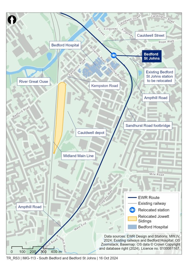
The route of East West Rail through Bedford starts at Ampthill Road in Kempston on the existing Marston Vale Line. The existing section of two-track railway would remain largely unchanged by the project. To achieve the East West Rail timetable, the single-track section from Sandhurst Road footbridge would be reconstructed as two-track to Bedford St Johns station.
To move Bedford St Johns station, we would need to realign the existing railway tracks, shifting them to the south-west, closer to properties and community facilities in the Ossory Way area.
During construction, it is likely that some or all the open space between Ossory Way and the railway would be used temporarily to enable us to build the railway. In doing so, we would seek to ensure the community would still be able to access the playground. Once construction is complete, we would reinstate and improve the existing open space and the land to the east of the new railway alignment. We are committed to working with local stakeholders to identify the best design for the realigned tracks, including suitable environmental mitigation where appropriate.
Further details on our proposals on the area south of Bedford St Johns station can be found in Chapter 8 of the Technical Report.
Figure 43: Indicative illustration of the alignment between the Marston Vale Line and Bedford St Johns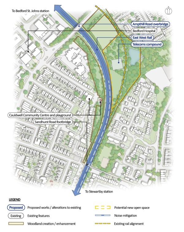
10.2.1 Ampthill Road realignment
Ampthill Road may need to be raised to provide enough clearance for the overhead line equipment that would be needed if full electrification in this area is required. To reduce the extent of the changes to roads that would be needed for overhead line electrification, we are also considering lowering the tracks in this area. We have carefully considered flood resilience as Bedford St Johns is close to the River Great Ouse and flooding near the station is possible. We know that additional drainage infrastructure would be needed in this area to manage potential flood risk.
Past Ampthill Road the railway would continue to head north-west through the existing Britannia Road car park. This is the proposed location of the new relocated Bedford St Johns station.
10.2.2 Relocated Bedford St Johns station
Relocating the existing Bedford St Johns station closer to Bedford Hospital would provide a better location that’s more convenient for patients, hospital staff and visitors. It would also make it easier to commute to workplaces in and around the Bedford St Johns area, such as local schools and businesses. The relocated station location would also benefit developments included in Bedford Borough Council’s adopted Local Plan 2030.
Figure 44: Map showing the proposed location of the relocated Bedford St Johns station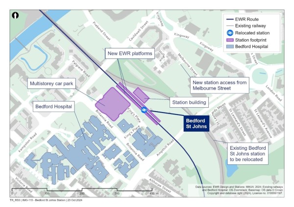
We need to relocate Bedford St Johns station to the current site of the Britannia Road car park between Ampthill Road and Cauldwell Street to provide long enough platforms for East West Rail services and to allow for a change in the curve of the railway so that trains can travel at higher speeds. With the curve of the current railway line, trains can only travel at 15mph. The realignment of the curve would allow trains to travel at 40mph.
The new station would offer enhanced facilities, including replacing existing ground level parking with a new multi-storey car park next to the new station. We are planning to build the new multi-storey car park on hospital-owned land west of our proposed tracks and we are working with Bedford Hospital and other stakeholders on these proposals. The new car park is expected to be up to nine floors in height.
10.2.3 Cauldwell Street and the River Great Ouse crossing
Past Bedford St Johns station the railway would pass under Cauldwell Street. We may need to raise the road and lower the railway track to provide sufficient clearance for the overhead line equipment should electrification in this area be required.
If this change to the road was needed, it would require the demolition of The Crown care home on the corner of Britannia Road, due to its proximity to the proposed highway works. A temporary diversion at the junction of Cauldwell Street and Prebend Street would be required during the reconstruction of Cauldwell Street bridge. North of Cauldwell Street, the route would follow the existing tracks over the River Great Ouse crossing.
The area which the railway runs through would also need to be widened. This change would temporarily impact the car parking and gardens of some properties in Palgrave Road during construction.
The junctions of Cauldwell Street with Prebend Street and Britannia Road would need to be reconstructed to accommodate the raising of Cauldwell Street bridge. The junction from Cauldwell Street to Cauldwell Place would have to be permanently closed as a result. Access to the businesses fronting Cauldwell Street would be provided via Holme Street to the rear.
We understand the effects these proposals could have on people who live and work in this area. We will be working with affected parties as the designs are further developed to agree measures to reduce the impacts of our proposals where possible. We will seek to enter into agreements with property owners where we would need to acquire property for our proposals.
Further details of these works are provided in Chapter 8 of the Technical Report.
Figure 45: Map showing the potential impacts around Cauldwell Street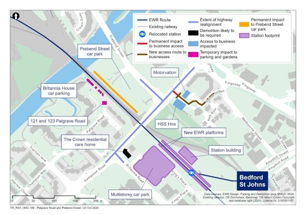
We might need to strengthen the existing crossing of the River Great Ouse to accommodate the increase in railway traffic. This will be confirmed at the next stage of design. The railway would be expected to remain at its current height above the river.
10.2.4 Jowett and Cauldwell sidings
To make space for the railway tracks in the approach to Bedford station, we propose to relocate the existing sidings at Jowett, where Thameslink trains are parked and maintained when not in use. The sidings would be relocated to a site near the existing Cauldwell depot which is on the Midland Main Line approximately 1.2km (0.7 miles) south of Bedford station.
A number of business premises at Cauldwell Walk would need to be acquired to enable us to build and operate the relocated sidings. We recognise the impact this would have and will be working with affected businesses to understand and mitigate these impacts where possible. As the designs are further developed we will seek to agree measures to reduce the impacts of our proposals where possible. We will seek to enter into agreements with property owners where acquisition cannot be avoided.
At the existing Jowett Siding site, there is an opportunity to retain and repurpose some of the sidings infrastructure for use by East West Rail which would minimise any need for development of an alternative stabling site. This opportunity will be explored further with more details provided at statutory consultation.
Figure 46: Map showing the Jowett sidings proposal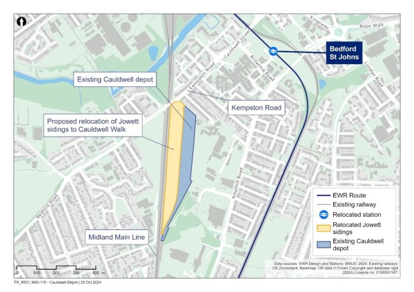
Under our proposals, one East West Rail track would pass through each of two arches under Ford End Road. This design aims to avoid the need to reconstruct part of the bridge, reducing construction time and disruption to the local community. Further surveys and technical assessments will be carried out to confirm if the existing brick arch spans can accommodate overhead line equipment without reconstruction.
10.3 Bedford station
East West Rail would provide easy access to the centre of Bedford, supporting plans to regenerate the town and helping local businesses to grow.
The current station site is constrained by car parks, roads, properties and railway boundaries. There is no direct, vibrant and pedestrian-friendly route from the station to the town centre, and most of the local public transport network doesn’t directly serve the station. There is also no direct pedestrian connection from the station to the River Great Ouse.
Our proposals would include major improvements to Bedford station, providing modern facilities and a public plaza at the front of the station that would improve access to the riverside and the town centre and reinforce Bedford’s status as a regional transport hub.
East West Rail would increase connectivity with the wider railway network, opening up more destinations with fast and direct east-west rail connections and supporting the economic development of the Bedford station area. These changes would provide a catalyst for regeneration in Bedford, support the local ambitions and aspirations for Bedford town centre.
Under our proposals, we would redevelop Bedford station, including the provision of two new platforms to allow East West Rail services to stop at the station. In addition, existing platform 1a would be widened and lengthened to create a platform for Thameslink.
At route update announcement in May 2023 we proposed three new platforms for Bedford station. Our changed service pattern (with an hourly service now running from Stewartby to Cambridge instead of Bedford to Cambridge) means that only two new platforms are now required, reducing the impact of construction around Bedford station.
The remodelled station building, entrance and concourse would be located on the current site of Bedford station Premium car park at the rear of the properties on Ashburnham Road. It would be accessed by road from Midland Road. Our station proposals would also incorporate measures to enable door-to-door connectivity including secure cycle parking, shared mobility provision and bus interchange.
Pedestrian access would be provided via new footbridges which would enhance passenger connectivity between platforms and assist interchange opportunities.
We are proposing new and improved parking facilities, including a multi-storey car park (anticipated to be up to eight floors in height) on Ashburnham Road on the site of the current station car park. During construction of the multi-storey car park, we would provide temporary parking on railway land to the south of Ford End Road.
To reduce the height of the multi-storey car park on Ashburnham Road, we are considering options for developing the existing surface car park adjacent to Bromham Road to provide a second multi-storey car park, potentially up to three floors in height. Final proposals for car parking will be provided at the statutory consultation after we have considered feedback from stakeholders.
Figure 47: Map showing proposals for Bedford station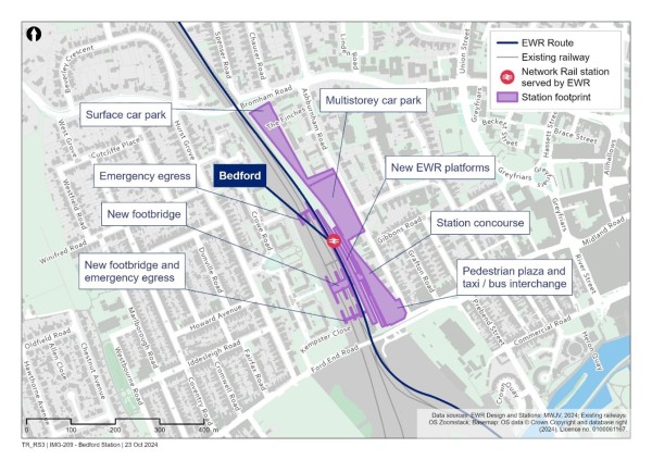
When we presented our initial proposals at the 2021 non-statutory consultation, we recognised they might affect several commercial and residential properties. Since the 2023 route update announcement, we have developed the station design to reduce the impact on the properties on Ashburnham Road. Our proposals would now only require the acquisition of a small part of the car park to the rear of the Dom Polski club. No other business premises are proposed to be acquired.
Further information on our proposals for Bedford station and their impact on surrounding properties can be found in Chapter 8 of the Technical Report.
Figure 48: Indicative illustration of Bedford station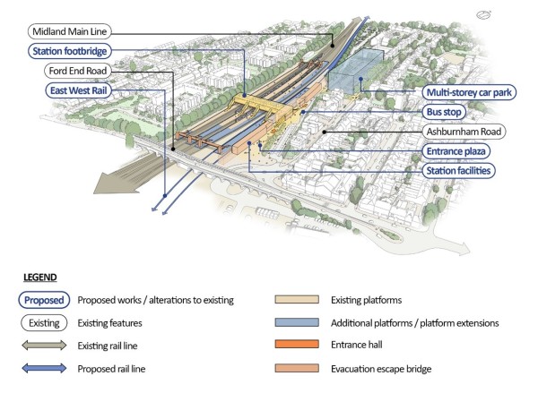
10.4 North of Bedford
At the 2023 route update announcement we confirmed our preference to construct two additional tracks to the east of the Midland Main Line, creating a six-track corridor to the north of Bedford station. We explained why four tracks would not be sufficient to meet the needs of East West Rail, as well as the needs of other train operators. Since then, we have continued to explore alternatives and how we could reduce the impact of these works, including considering whether a five-track option would be sufficient. We have also considered the content of the independent report commissioned by Bedford Borough Council to investigate the need for additional tracks to serve East West Rail trains.
This work has reconfirmed the need for two additional tracks as set out at the route update announcement.
The current four-track railway is already congested with a high volume of trains passing through Bedford station. It would be extremely difficult to fit East West Rail services into the timetable if trains were to use the slow lines of the current four-track Midland Main Line. The timetable is complex and is driven by constraints on the wider network, including, for example, the timing of Thameslink services through central London. Also, there would be a need to weave existing freight services through the station area on specifically timed paths due to the number of platforms occupied by Thameslink services. If East West Rail trains shared the lines north of Bedford with non-East West Rail services, these constraints would mean that Thameslink and freight services would likely be prioritised because of the need to reduce knock-on effects across the wider network. This would affect the reliability of East West Rail services from the outset.
We have looked at whether a five-track option would be sufficient. Adding a single extra track to create a five-track corridor would not remove the constraints described above. It would also require a similar amount of land to the six-track proposal.
Figure 49: Map showing East West Rail route proposals north of Bedford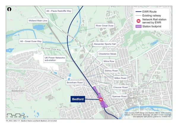
10.4.1 Bromham Road
North of Bedford station, two new tracks would run parallel with the existing four-track Midland Main Line, creating a six-track corridor. Bromham Road overbridge would need to be extended eastwards to allow for these new tracks to pass underneath.
10.4.2 Poets area
The two new tracks would continue alongside the four-track Midland Main Line as it passes the Poets area.
At the route update announcement in 2023 we explained the continuing work that we are doing to reduce the impact of the railway on properties in the Poets area. We confirmed a reduction in the number of residential properties likely to be acquired and demolished from 53 to 37 and an overall reduction in the number of properties likely to be acquired and demolished, or lose part of their land, from 98 to 66.
The number of residential properties to be acquired and potentially demolished as reported at the route update announcement has not changed from 37. However, after further design development, the number of properties that may have part of their garden or parking area acquired has increased from 28 to 37. The overall number of properties likely to be acquired and demolished, or lose part of their land, has increased from 66 to 75. This is because:
- There is a need for a turning area on Chaucer Road, resulting in the need to acquire part of the garden area of a block of flats comprised of nine properties. The design of the turning area aims to reduce land take as far as possible.
- A link road is needed to maintain access between Milton Road and Sidney Road which would partially affect the garden of one property.
- Improved understanding of property ownership has identified that what was considered to be one property is actually split into two ownerships.
- A review of the construction approach has established that the partial acquisition of garden areas of two properties would no longer be required.
Figure 50: Map showing the potential property impacts in the Poets area, including highway works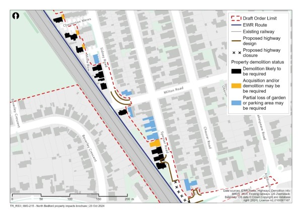
We understand the significant effects these proposals would have on those people whose homes and businesses would be affected by the construction of the new tracks. We will continue to talk with all those potentially impacted by our proposals in this area. We have established our Need to Sell Property Scheme for those who are unable to sell their property because of our proposals. Homeowners in this area will also benefit from the statutory blight provisions that come into effect alongside this consultation. You can find more information on these property schemes at https://eastwestrail.co.uk/planning/land-and-property.
10.4.3 A6 Great Ouse Way
North of the Poets area, construction of the railway would require the acquisition of a strip of land along the western edge of Alexander Sports Hall playing field, including the pavilion in the corner of the playing fields, which would need to be relocated. The UK Power Networks (UKPN) substation would need to be reconfigured within its existing site to accommodate the two additional tracks.
Once past the UKPN substation, the proposed railway would diverge from the Midland Main Line and climb as it heads east towards Cambridge. The A6 Great Ouse Way would require realignment to separate the railway and the A6.
10.4.4 River Great Ouse Viaduct
Once north of the A6 Great Ouse Way, the railway would continue to rise on a viaduct to cross twice over the River Great Ouse and its floodplain, as well as the A6 Paula Radcliffe Way. Our proposed viaduct would be approximately 1.1km (0.68 miles) long.
A viaduct is proposed because this would reduce the risk of flooding that could occur if the railway was to cross this area on an embankment. It would also reduce the extent of land required for flood storage and the amount of land that the project would need to permanently acquire. There are existing power lines in the vicinity of the railway which would need to be rerouted to avoid the viaduct.
Once east of the second crossing of the River Great Ouse, the railway would pass over Clapham Road where it would connect to the next route section Clapham Green to Colesden.
Figure 51: Indicative illustration of the viaduct over the River Great Ouse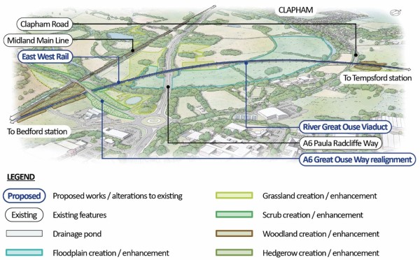
10.5 Share your feedback
We would like to hear your feedback on our proposals for the Bedford route section. We are particularly interested in your views on:
- Our proposed improvements at south Bedford and St Johns station, including:
- Ampthill and Cauldwell Street realignment.
- Cauldwell Street and the River Great Ouse crossing.
- Jowett sidings relocation to Cauldwell Walk.
- Our proposed improvements at Bedford station.
- Our proposals for other key features in this route section including
- Bromham Road extension.
- Poets area.
- A6 Great Ouse Way.
You can find details of how to respond to our consultation in the Have your say section of this Consultation Document.
11. Building a new railway between Clapham Green and Shelford
To run passenger services from Oxford through to Cambridge, we need to build a new railway between Bedford and Cambridge.
The new railway would enable four new passenger trains an hour between Bedford and Cambridge. We would build new stations at Cambourne and Tempsford, giving local communities in these areas additional options for travel around the region and beyond, cutting journey times, reducing congestion and opening up access to more jobs and more destinations. The train journey from Cambourne to Cambridge, for example, would take just 15 minutes, compared to over 50 minutes in rush hour on the road today.
The railway would need go through cuttings, embankments, bridges and viaducts. It would also require some roads and public rights of way to be diverted and some passing loops to be constructed. The following chapters outline our proposals for four route sections:
- Clapham Green to Colesden.
- Roxton to east of St Neots.
- Croxton to Toft.
- Comberton to Shelford.
11.1 How proposals from north of Bedford to Cambridge have developed
The preferred route is based on the route update announcement that was published in 2023. This followed extensive public consultation and engagement, including non-statutory consultations in 2019 and 2021 on alternative routes and alignments for this section of the railway. More detailed analysis has taken place since then to design the railway in this section.
Table 3 provides more information on the steps that have been taken to reach the latest route designs.
Table 3: Summary of design development for the route section between Clapham Green and Shelford
|
Year |
Key milestones |
|
2019 |
2019 Bedford to Cambridge non-statutory consultation The first non-statutory public consultation on East West Rail ran between 28 January and 11 March 2019. This provided an opportunity for local communities and other stakeholders to provide feedback on nine route options for the new rail line between Bedford and Cambridge. |
|
2020 |
Preferred Route Option announced On 30 January 2020 the then Secretary of State for Transport, the Rt. Hon. Grant Shapps MP, announced the preferred route option for East West Rail, between Bedford and Cambridge. The route was chosen following detailed analysis, including careful consideration of responses to the 2019 public consultation. This route was known as Route E in the 2019 consultation. |
|
2021 |
2021 non-statutory public consultation The second non-statutory public consultation on East West Rail ran between 31 March and 9 June 2021. This consultation covered a range of infrastructure proposals - such as route alignments, stations and level crossings, as well as the overall customer experience and railway operations for East West Rail. Building on the 2019 public consultation and the route option announcement, this consultation included five specific route alignment options for the Bedford-Cambridge section of the railway within the Route E route option area. |
|
2022 |
Ongoing refinement and analysis Proposals for this section of the route were refined following technical studies, detailed analysis and careful consideration of more than 190,000 individual comments in response to the 2021 consultation. |
|
2023 |
Route update announcement Based on work carried out since the 2021 public consultation, we updated the preferred route alignment – Alignment 1 (Tempsford variant) – and published this as part of the route update announcement in May 2023. |
|
2024 |
Non-statutory consultation This consultation includes more detail about our proposals for the section of the railway between Bedford and Cambridge via Tempsford. |
11.2 How proposals for Clapham Green to Shelford have developed
In our 2021 non-statutory consultation, this section of the route was included in a larger section named Clapham Green to The Eversdens. At that time, we had not decided on the preferred alignment for that part of the route or whether the route should serve a station at either Tempsford or St Neots before continuing to Cambourne. We presented five possible route alignments and six potential new station locations for feedback. We indicated our emerging preferences as:
- Alignment 1, which would have travelled through north of Ravensden, Wilden and Roxton and serve a new St Neots south station.
- Alignment 9, which would have travelled through south of Ravensden, Wilden and Roxton and serve a new Tempsford station.
Following further technical and design work, and consideration of responses to the 2021 non-statutory consultation, the 2023 route update announcement set out our preference to use Alignment 1 for most of its length, with a local route variation to allow it to serve a new station at Tempsford. This updated alignment was referred to as Alignment 1 (Tempsford variant).
More information on the proposed route between Colesden and Tempsford can be found in the Roxton to east of St Neots chapter of this Consultation Document.
Work we have done since the route update announcement
Since the May 2023 route update announcement, we have further developed the design for our proposals between Clapham Green all the way through to Shelford and sought to reduce their impacts on the local community and other stakeholders.
We are inviting your feedback on our proposals for this section of the route, which you can read about in more detail in the following three sections.
12. Route section – Clapham Green to Colesden – construction of new railway
This section of the route involves the construction of approximately 12km (7 miles) of new, twin-track railway between Clapham Green (north of Bedford) and Colesden (north-east of Bedford).
This chapter covers:
- An overview of how proposals have developed since last year’s route update announcement.
- How we have considered the environment to develop our proposals.
- Specific proposals around:
- Clapham Green to Ravensden.
- Ravensden to Colesden.
- How to share your feedback using the feedback form.
12.1 What we are proposing and why
Here's what we are proposing for this section of the route, and why:
- We are planning to lay approximately 12km (7 miles) of new railway track and build embankments, cuttings, bridges and viaducts where needed to enable this.
- We are thinking about how we would need to divert some roads, tracks and paths that cross the new railway so that these can still be used, for example by building new bridges.
- Near Colesden, we are proposing to install two passing loops so that faster passenger trains could overtake slower trains, including freight.
- Along the route section, we are considering how best to provide balancing ponds to manage flood risk and looking at what utilities may require diversions, such as overhead electricity transmission lines.
Work we have done since the route update announcement
Since the May 2023 route update announcement, we have further developed the design for our proposals between Clapham Green and Colesden and sought to reduce their impacts on the local community and other stakeholders.
Figure 52: Map showing Clapham Green to Colesden route section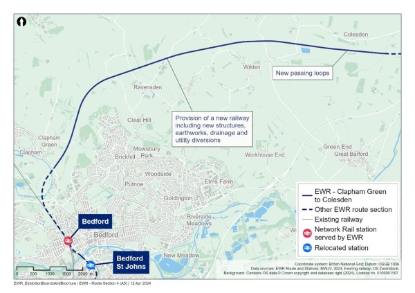
How we have considered the environment when developing our proposals
As we continue to develop our proposals for this section of East West Rail, we are thinking carefully about a number of environmental matters, including:
Landscape and visual
- We are considering mitigation planting and other measures that would minimise the potential visual impacts from the addition of new structures such as embankments, viaducts and bridges north-east of Clapham Green.
Biodiversity and nature conservation
- Our ongoing assessments will identify potential impacts on habitats and wildlife within the countryside, and our designs will be developed to avoid habitat fragmentation and maintain connectivity as far as possible.
Water resources and flood risk
- Our assessment will determine suitable measures to ensure our works would not deteriorate the water quality and characteristics of the Ouse Catchment, and other water bodies in the catchment area. Detailed modelling will be undertaken to assess flood risk and design appropriate mitigation.
Historic environment
- We will undertake an assessment of any significant heritage impacts, and incorporate appropriate mitigation in our designs. This includes considering the potential impacts on The Lodge at Clapham Park, Gray’s Hill Farmhouse near Ravensden, Manor Farmhouse and cottages at Wood End, and Bell Farmhouse and barn near Colesden. Measures to reduce construction impacts will also be included in a draft Code of Construction Practice, which will be submitted as part of our DCO application.
Initial information about potential impacts and mitigation concepts in this route section are provided in Chapter 8 of the Environmental Update Report.
12.2 Clapham Green to Ravensden
After leaving Bedford on a new viaduct, the railway would head north-east towards Clapham. The railway would go south of Clapham and Clapham Green and travel along an embankment before entering a cutting and going underneath Carriage Drive between Clapham Green and Clapham Park. The railway would be to the east of the Bedford and County Golf Club.
Within the cutting between Clapham Green and Clapham Park, the railway would pass under Carriage Drive, Clapham Footpaths 5 and 6, and Brickhill Bridleway 54. As the route is in cutting here, Clapham Footpath 9 would be closed with users diverted to Clapham Footpaths 8 and 24. We would construct a new bridge for Carriage Drive to pass over the new railway at a similar level to the current road. Construction would be planned to maintain access to local properties while this bridge is built. We would also construct a new footbridge over the railway where Clapham Footpaths 5 and 6 meet.
It would be necessary to divert part of Brickhill Bridleway 54 towards the end of the northern cutting on a bridge over the railway.
Figure 53: Map showing crossing of the railway at Carriage Drive and Clapham Footpaths 5 and 6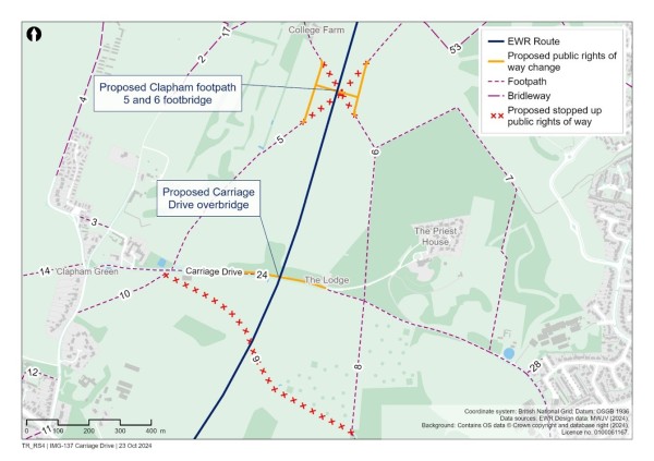
Due to the rolling hills and brooks in this area, a series of cuttings, embankments and bridges would be built. The railway would pass beneath Graze Hill Lane in a 600m (656 yards) long cutting, and the road would cross over the railway using a new overbridge.
To cross over Thurleigh Road, the railway would be on an embankment. To enable construction to take place without closing Thurleigh Road, the road itself would be diverted by approximately 40m (44 yards) to the west.
There are several public rights of way in the Graze Hill and Thurleigh Road that would be modified:
- Ravensden Bridleway 4, would be adjusted to tie-in to the realigned Thurleigh Road.
- Ravensden Footpaths 5, 46 and 47 would be closed with a diversion provided using the realigned Thurleigh Road, Ravensden Bridleway 4 and Ravensden Footpath 4.
The new railway would then cross over Ravensden Brook on a new bridge to the east of Thurleigh Road.
Figure 54: Map showing public rights of way in the Graze Hill and Thurleigh Road area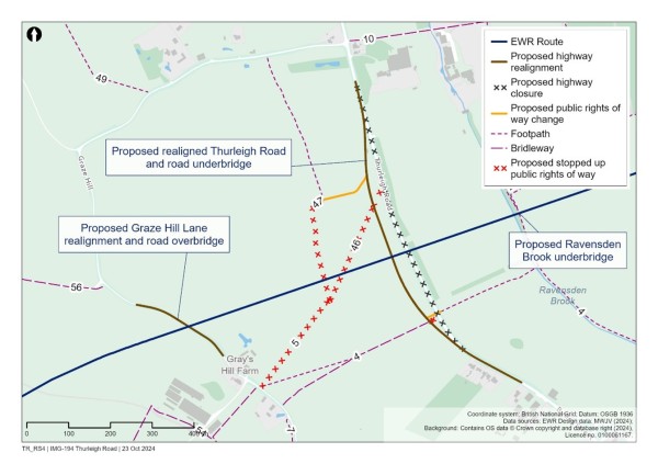
12.3 Ravensden to Colesden
Since the 2021 non-statutory consultation we have moved the proposed alignment of the railway slightly to the north in this area. This would move the railway further away from properties in Wilden.
A series of cuttings and embankments would be needed as the railway passes to the north of Ravensden. The railway would pass in a cutting beneath Sunderland Hill, which would cross the railway on a new overbridge at a similar height to the existing road.
There are several public rights of way close to Sunderland Hill which would be diverted to maintain local connectivity:
- Ravensden Byway 61 would be diverted to run along the southern edge of the route to join the Sunderland Hill overbridge.
- To the east of the cutting under Sunderland Hill, a new footbridge would be constructed for Ravensden Footpath 35 to cross the railway approximately 50m (55 yards) to the west of its current route.
- Wilden Footpath 22 would also use this footbridge as a crossing point, approximately 400m (437 yards) west of its current crossing location, with new footpaths provided either side of the railway to provide access to the footbridge.
An additional farm access track would be provided in this area to the north of the railway to maintain field access.
Figure 55: Map showing the public rights of way footpath diversions and the proposed route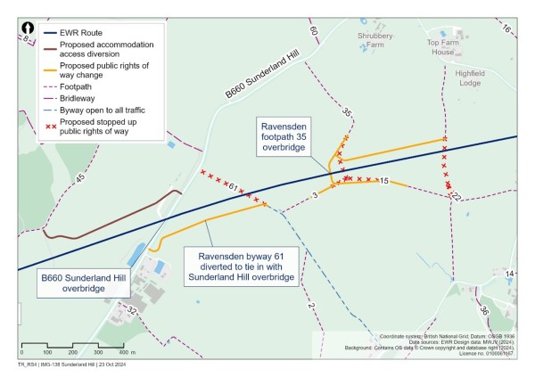
Once the railway has gone under Ravensden Footpath 35, it would pass over Shrubbery Lane on an embankment. The railway would then pass over South Brook West on a new viaduct.
Wilden Footpath 16 would be diverted to the west of the brook. To the east of the brook, a proposed maintenance road would follow Wilden Footpath 33 from Wilden High Street. Wilden Footpath 27, also known as the North Bedfordshire Heritage Trial long path, would cross the railway using a new bridge built on a similar alignment to the current path.
Figure 56: Map showing Wilden area crossings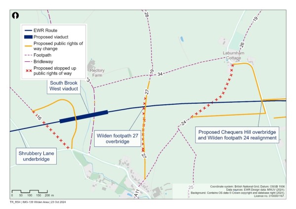
The railway would then pass beneath Chequers Hill and Colesden Road in a cutting approximately 3km (1.9 miles) long. A new bridge would be constructed approximately at ground level to take Chequers Hill over the railway and accommodate a diversion of Wilden Footpath 24.
Further east along the cutting, Colesden Road would cross the railway. For this to happen, the road would be diverted and would need to rise to approximately 7m (23 feet) above ground level. To maintain access to local properties and Wilden Lakes, a new access road would be constructed from the diverted Colesden Road.
To the east of the Colesden Road bridge, the railway would continue on a series of low embankments for approximately 1km (0.6 miles). We would construct two passing loops in this area to enable faster passenger services to overtake slower trains, reducing delays and disruption.
There are a number of footpaths in the area of the passing loops, so we would build a new bridge at Wilden Bridleway 16, which would provide a joint crossing point for Wilden Bridleway 1, Colesden Bridleway 16, Wyboston Chawston and Colesden Footpath 15 and a farm access track.
The railway would then cross the western slope of the River Great Ouse Valley, which would require a series of embankments before crossing over South Brook East on a short viaduct.
Figure 57: Map showing proposed public rights of way in the Colesden area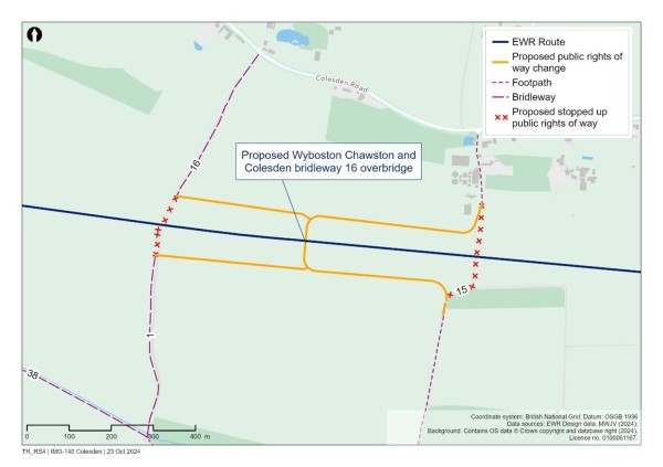
12.4 Share your feedback
We would like to hear your feedback on our proposals for the Clapham Green to Colesden route section. We are particularly interested in your views on:
- Our proposed changes to public rights of way.
- Our proposed changes to road alignments.
- Issues and opportunities we need to consider as we develop our proposals for passing loops near Colesden.
- Issues and opportunities we need to consider as we develop our proposals for the railway in this section.
You can find details of how to respond to our consultation in the Have your say section of this Consultation Document.
13. Route Section – Roxton to east of St Neots – construction of new railway and station
This section of East West Rail runs between Roxton and east of St Neots, which is approximately 10km (6 miles) long, beginning at South Brook, north of Roxton and Tempsford, and running to the east of Little Barford and St Neots. It ends where the B1428 Cambridge Road joins the existing A428 at the roundabout east of St Neots.
This chapter covers:
- An overview of what we are proposing and why, including how proposals have developed since last year’s route update announcement.
- How we have considered the environment when developing the proposals.
- Specific proposals around:
- Route alignment options
- Tempsford station
- Creating a temporary rail logistics hub on the East Coast Main Line
- How to share your feedback using the feedback form
13.1 What we are proposing and why
This section of East West Rail would bring a brand-new station to Tempsford, designed to enable a new community to grow. The station would be located at the centre of the local travel network, making it easier and quicker to travel around the region and beyond, reducing congestion, and driving economic growth.
The route is based on the route update announcement that was published in 2023, which followed extensive public consultation and engagement.
Here’s what we are proposing for this section of the route, and why:
- We are planning to construct a section of twin-track railway and associated infrastructure approximately 10km (6 miles) long. As part of the 2023 route update announcement we confirmed that Alignment 1 (Tempsford variant) was the preferred alignment for the route between Bedford and Cambridge. This alignment would serve a new station at Tempsford. Since then, we have developed two local variations, Alignment 1b and Alignment 1c, each making use of viaducts linked by embankment. Alignment 1b has been developed from the route update announcement proposals and runs south of the A421. Alignment 1c is an alternative running north of the A421 with connections to the south.
- At Tempsford, we are proposing a new station to serve existing and future communities which would also include an interchange with the East Coast Main Line to enable travel further afield. As the station design is progressed it will include consideration of existing communities as well as planned and potential development within the area.
- We are considering the best location for a temporary rail logistics hub connecting with the proposed alignment and the East Coast Main Line to enable construction materials to be transported by rail, reducing the amount of construction traffic on local roads.
- We are thinking about how to construct new overbridges and underbridges, provide balancing ponds and undertake utility diversions, including overhead electricity transmission lines.
Work we have done since the route update announcement
Since the route update announcement, we have further developed the design for the proposals, and sought to reduce their impacts on the local community and other stakeholders. We have undertaken further design work which has identified two localised alternatives in the Tempsford area which improve upon the alignment presented at the route update announcement. The details of these alternatives (referred to as Alignment 1b and Alignment 1c) are set out in this chapter, along with options for the location of Tempsford station and a temporary rail logistics hub.
Figure 58: Map showing Roxton to east of St Neots route section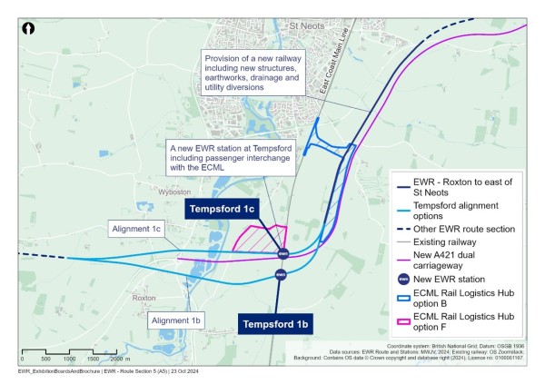
How we have considered the environment when developing our proposals
As we continue to develop our proposals for this section of East West Rail, we are thinking carefully about a number of environmental matters, including:
Noise
- Noise modelling will be conducted to understand any potential noise impacts due to passing trains and identify where mitigation, such as noise barriers, may be needed.
Landscape and visual
- We will carry out a landscape and visual impact assessment to understand the potential impacts from the new viaduct crossing the River Great Ouse, which will be a prominent new visual feature, and how we can mitigate the visual impacts as far as possible.
Temporary impacts from rail logistics hub
- The construction logistics hub between the new railway and the East Coast Main Line could result in a range of temporary impacts including noise, dust, and traffic impacts. Measures to reduce these impacts will be included in a draft Code of Construction Practice, which will be included as part of our DCO application.
Biodiversity and nature conservation
- We will undertake detailed modelling to assess potential impacts to the habitats of the River Great Ouse county wildlife site. We will design the viaduct and associated mitigation measures to reduce these impacts as far as possible, and make sure that links with nearby woodland habitats are maintained.
Historic environment
- We will undertake an assessment of any significant heritage impacts, and incorporate appropriate mitigation in our designs, including considering the potential impacts on the setting of groups of listed buildings in Roxton, Tempsford and Little Barford.
Initial information about potential impacts and mitigation concepts in this route section are provided in Chapter 9 of the Environmental Update Report.
13.2 Route alignment options
As part of the 2023 route update announcement we confirmed that Alignment 1 (Tempsford variant) was the preferred alignment for the route between Bedford and Cambridge. This alignment would serve a new station at Tempsford. In this section of the Consultation Document, this alignment is referred to as Alignment 1a.
The route update announcement also explained that the preferred alignment may be subject to adjustment and refinement because of ongoing assessments and design work, including discussions with National Highways to explore opportunities to better coordinate and align with the A428 Black Cat to Caxton Gibbet improvements scheme (the ‘A428 scheme’).
Following the route update announcement, we have developed two local variations of Alignment 1 (Tempsford variant), which we now refer to as Alignment 1a. The two local variations are referred to as Alignment 1b and Alignment 1c. They offer additional benefits, including closer alignment to the new A421 dual carriageway currently being constructed by National Highways as part of the A428 scheme.
The key differences between Alignment 1b and Alignment 1c are:
- Alignment 1b follows a similar alignment to Alignment 1a south of the Black Cat roundabout, whereas Alignment 1c runs slightly north of the Black Cat roundabout.
- The maximum height of the railway for Alignment 1b would be higher than the maximum height for Alignment 1c – including at Tempsford station where Alignment 1b is more than twice the height of Alignment 1c. The tracks would be approximately 22m (72 feet) above ground level for Alignment 1b and approximately 9m (29 feet) for Alignment 1c).
- In Alignment 1b, Tempsford station would be located south of the new dual carriageway, and more centrally in a potential Tempsford development. In Alignment 1c, Tempsford station would be located to the north of the new A421 dual carriageway, close to the northern edge of a potential Tempsford development.
Our assessment shows Alignment 1c offers a number of advantages over Alignment 1b. The railway in Alignment 1c is significantly lower at Tempsford station, reducing its visual impact. It’s also a more affordable option, as it doesn’t require the longer viaduct that would be included in Alignment 1b to cross the A421 dual carriageway.
Alignment 1c offers other advantages too, including in relation to railway operational performance, deliverability and consistency with Local Plans.
It was noted in our assessment that Alignment 1c may have a slightly reduced potential to unlock economic growth in the Tempsford area compared to Alignment 1b. Further work being carried out indicates that the reasons for this difference are capable of being addressed and that either Alignment 1b or Alignment 1c could support substantial development at Tempsford. In both cases Tempsford station would sit at the northern edge of the proposed wider development – so both would require good door-to-door connectivity to serve a new development effectively.
We will do additional work to develop the station design and consider how best to provide an efficient interchange with the East Coast Main Line and further unlock economic growth. Feedback received as part of this consultation will be taken into account in the further development of the railway alignment and Tempsford station design.
Figure 59: Map showing alignment options 1a, 1b and 1c for Tempsford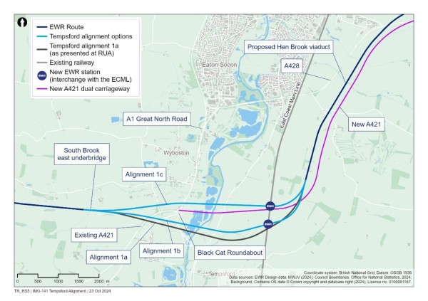
13.3 Alignment 1b: south of Black Cat roundabout
Alignment 1b would follow a similar alignment to Alignment 1a presented at the route update announcement, south of the Black Cat roundabout. Immediately to the east of South Brook, the railway would be on embankment up to approximately 17m (55 feet) above ground level. The embankment would be 1.2km (0.75 miles) long, reaching the existing A421, which will be realigned in the vicinity of the Black Cat roundabout as part of the National Highways A428 scheme.
To cross over the existing A421, Bedford Road, the A1 Great North Road to the south of the Black Cat roundabout and the River Great Ouse, a 1.6km (1 mile) viaduct is required. The viaduct would need to be approximately 17m (55 feet) high as it needs to cross the new dual carriageway, which itself is constructed on an embankment, and its length is required to carry the railway through areas of flood risk.
The construction of this viaduct could potentially impact Green Acres residential property, and would directly impact the Roxton Garden Centre, which is identified as part of a proposed employment allocation within the emerging Bedford Local Plan 2040. If this alignment option is progressed, we would work with National Highways and the affected property owners to understand the full impact of the proposals to identify and explore potential mitigation measures.
The railway would return to embankment for 120m (131 yards) before crossing over Barford Road and the East Coast Main Line on a viaduct, where Tempsford station would be constructed. The railway would then cross over the new dual carriageway (to be known as the A421), being constructed as part of the A428 scheme. The viaduct would be approximately 24m (72 feet) high to safely cross over the A421, which itself is approximately 9m (30 feet) above ground level on an embankment at this point. This second viaduct would be approximately 2.4km (1.5 miles) long.
Figure 60: Indicative illustration of Alignment 1b (Alignment 1c shown in dashed line)
13.4 Alignment 1c: north of Black Cat roundabout
The main difference between Alignment 1b and Alignment 1c is that 1c would run to the north of Black Cat roundabout and would not cross the existing or new A421 (currently in construction as part of the A428 scheme).
Immediately to the east of South Brook, the railway would be on embankment up to approximately 15m (49 feet) above ground level for a length of approximately 1.5km (0.9 miles) until it reaches Roxton Road (which is to be realigned by the A428 scheme). Wyboston, Chawston and Colesden Footpath 10 would be diverted to the east to go around this embankment.
At Roxton Road, the railway would cross:
- Roxton Road
- Two footpaths (Wyboston Footpaths 7 and 8)
- The A1 Great North Road to the north of the Black Cat roundabout
- The River Great Ouse
Crossing these features would require a viaduct up to 15m (49 feet) high, running parallel with the new dual carriageway to be known as the A421 for a length of approximately 1.6km (1 mile) as the alignment passes through areas of flood risk.
The railway would then pass under Barford Road which we would realign onto a bridge over the railway close to existing ground level. It would then transition onto an embankment for approximately 900m (980 yards) and up to approximately 8m (26 feet) above ground level.
To accommodate the new Tempsford station and cross over the East Coast Main Line, the railway would return to a viaduct approximately 700m (765 yards) long and up to approximately 10m (32 feet) above ground level.
Figure 61: Indicative illustration of Alignment 1c (Alignment 1b shown in dashed line)
13.5 Alignment 1b and 1c common route
Both alignments would run north along the western side of the new dual carriageway being constructed as part of the National Highways A428 scheme (which will become known as the A421). Keeping the height of the railway low, the railway would pass beneath the B1046 St Neots Road, which would cross over the railway on a new bridge close to existing ground level. The railway would then cross over Hen Brook on a new viaduct and over the tributary of Fox Brook on a new bridge. The railway would then go into a cutting beneath the Abbotsley Footpath 17 footbridge before reaching the end of this route section at the junction of the B1428 Cambridge Road and the existing A428 to the east of St Neots.
13.6 Tempsford station options
Both proposed alignments, 1b and 1c, would include a new station to serve existing communities and potential future development in the Tempsford area. The station would include two East West Rail platforms and two East Coast Main Line platforms, with a station building and passenger connections between the two railways. Step-free access would be provided throughout the station, along with an active travel hub including cycling facilities, bus facilities and a car park. The station designs for Alignments 1b and 1c would both enable connections to future development areas south of the station.
For both proposed alignments, the railway tracks would be elevated on a new viaduct in the location of the proposed station, where there would be two East West Rail platforms on the viaduct and two East Coast Main Line platforms on the existing slow lines at ground level. The viaducts are needed due to the interface with major highways and to cross over the existing East Coast Main Line.
Alignment 1b would be approximately 22m (72 feet) above ground level and would cross over the Barford Road on a viaduct. Alignment 1c would be approximately 9m (29 feet) above ground level and cross under Barford Road, meaning a new overbridge would need to be constructed. Both station options would be accessed from a realigned Barford Road. As the Tempsford Station design is progressed it will include consideration of existing communities as well as planned and potential development within the area.
13.7 East Coast Main Line rail logistics hub
To shorten the construction programme and reduce the impacts of construction on local communities and the environment, we are considering building a temporary rail-based logistics hub to support the construction of the railway. The hub would have a connection to the East Coast Main Line, which would mean construction materials could arrive by rail and be distributed along the route. This would reduce the number of heavy goods vehicles on local roads during construction, reducing congestion and damage to local roads.
Various recent infrastructure projects including HS2 and the London Olympic Park have shown the benefits of using this approach to relieve pressure on the road network and reduce the carbon footprint of projects.
The potential to connect a rail logistics hub to the Midland Main Line at Bedford, or the West Anglia Main Line or Shepreth Branch Royston Line near Cambridge was considered. However, capacity on these lines is limited. Consequently, a connection to the East Coast Main Line would provide the best opportunity for servicing the construction of East West Rail by rail. Its central location on the new section of railway would mean that it could support construction activity both to the east and west in parallel, minimising the overall construction period and reducing capital cost compared to more traditional ways of working. The logistics hub would be used for storage of material and construction and assembly activity which would enable efficient construction processes.
We looked at several potential sites (Options A to F) for the logistics hub and are now considering two possible locations for the hub, Option B and Option F.
Option B would be situated near Little Barford to the east of the East Coast Main Line between the proposed East West Rail alignment and new A421 dual carriageway currently in construction as part of the A428 scheme. This option is compatible with both Alignments 1b and 1c. The site would be approximately 1.5km (0.95 miles) long and 150m (164 yards) wide. Connections to the East Coast Main Line would be via the southbound slow line. Highway access would be provided to the north of the site, connecting with the newly diverted B1046 St Neots Road. The construction of this option would directly impact Top Farm (also impacted by Alignment 1b and 1c) and Rectory Farm.
Option F is only compatible with Alignment 1c. It would be located to the west of the East Coast Main Line, north of Alignment 1c and south of Little Barford. Connection to the East Coast Main Line would be with the northbound slow line and would be to the north of the proposed East Coast Main Line northbound platform. The site would be approximately 1km (0.7 miles) long and 500m (0.3 miles) wide and highway access would be to the west of the site, connecting with Barford Road. Under this option, the hub would sit within an area where potential development at Tempsford could come forward. This might constrain the delivery of potential development should it be brought forward prior to East West Rail.
Figure 62: Map showing East Coast Main Line Logistic Hub options B and F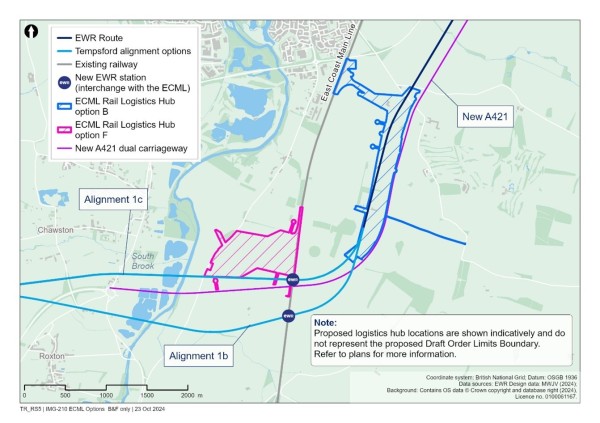
We do not intend to select a rail logistics hub location until further stakeholder feedback has been taken into account and a decision on the preferred Tempsford Alignment 1b or Alignment 1c has been made.
13.8 Share your feedback
We would like to hear your feedback on our proposals for the Roxton to east of St Neots route section. We are particularly interested in your views on:
- Alignment 1b and Alignment 1c.
- Issues and opportunities we should consider as we develop plans for the new Tempsford station.
- Factors we need to bear in mind as we consider the temporary East Coast Main Line rail logistics hub proposal.
- Issues and opportunities we need to consider as we develop our proposals for the railway in this section.
You can find details of how to respond to our consultation in the Have your say section of this Consultation Document.
14. Route section – Croxton to Toft – construction of new railway and station
This section of the route is approximately 19km (12 miles) long. It begins at the roundabout east of St Neots, running north of Cambourne and the new dual carriageway to be known as the A421 and A428, before crossing the A428 and ending at the B1046 between Toft and Comberton.
This chapter covers:
- An overview of what we are proposing and why, including how our proposals have developed since last year’s route update announcement.
- How we have considered the environment when developing our proposals.
- Specific proposals around:
- Cambridge Road junction.
- Abbotsley to Toseland Road.
- Eltisley to Cambourne.
- Cambourne and Cambourne station.
- A428 Bourn Airfield crossing.
- Hardwick to Toft.
- How to share your feedback using the feedback form.
14.1 What we are proposing and why
In this section of the route we are proposing a new station at Cambourne, which would make it easier and quicker for people to travel into Cambridge – a journey that currently can take longer than it should because of congested roads and a lack of public transport. Four trains an hour would stop at Cambourne station going to Cambridge – from Oxford, Bletchley, Stewartby and Bedford.
It can take nearly an hour to travel just nine miles by car from Cambourne to the centre of Cambridge in the morning rush hour, or around 50 minutes by bus. Travelling with East West Rail would mean a journey time of just 15 minutes from Cambourne to Cambridge station. A new station at Cambourne would help to expand the number of people within commuting distance of employment opportunities in the region, reduce congestion and drive economic growth. As the Cambourne station design is progressed it will include consideration of existing communities as well as planned and potential development within the area.
Our designs for this section of the route take account of the layout of the new 16km (10 miles) A421 dual carriageway currently being constructed by National Highways as part of the A428 scheme, which is due to open in 2027. We continue to engage with National Highways and local authorities to assess, mitigate and manage the potential impacts on the A421 and wider road network.
Here’s what we are proposing for this section of the route, and why:
- We are planning to construct approximately 19km (12 miles) of twin-track railway including passing loops, to enable travel by railway from Bedford to Cambridge.
- At Cambourne, we are planning to build a new station to improve connectivity into Cambridge for people living there and support the future growth of the town.
- To reduce the environmental impact of the railway, we propose constructing a cut and cover tunnel beneath the A428, the proposed Bourn Airfield development and Highfields Road, with an associated temporary diversion of the A428 and other local roads.
- We are thinking about how we would need to construct bridges for road, track and path crossings, bridges and culverts for watercourses and associated diversions where necessary.
- We are looking at how to provide various balancing ponds and how to divert utilities including overhead electricity transmission lines.
Work we have done since the route update announcement
Since the May 2023 route update announcement, we have further developed the design for these proposals, and sought to reduce their impacts on the local community and other stakeholders.
Figure 63: Map showing Croxton to Toft route section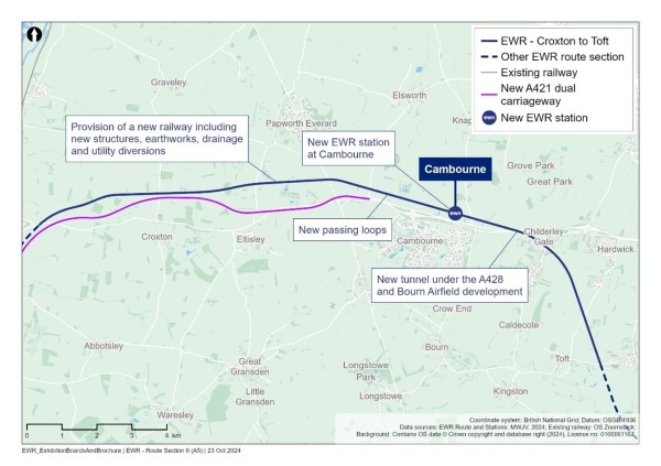
How we have considered the environment when developing our proposals
As we continue to develop our proposals for this section of East West Rail, we are thinking carefully about a number of environmental matters, including:
Landscape and visual impacts
- Replacement planting would help mitigate visual impacts as far as possible and integrate the proposed new structures into the surrounding area. We will consider potential impacts on views from the roads and residential properties between Croxton and Papworth Everard, and the impact which new overbridges and cuttings could have on the landscape between Highfields Caldecote and Toft.
Biodiversity and nature conservation
- Barbastelle bats are present in the area around Eversden and Wimpole Woods. Maintaining connectivity and enhancing their foraging areas will be a key consideration for the project design and mitigation. There would be no direct impacts on linked ancient woodlands (Elsworth Wood and Knapwell Wood). We are assessing potential indirect impacts to the woods and the bat population and how these can be mitigated.
Water resources and flood risk
- Detailed modelling will be undertaken to assess flood risk and drainage impacts and design appropriate mitigation. The railway would cross a number of watercourses including Bourn Brook, Fen Drayton drain, West Brook, and the Ouse (Roxton to Earith). Bourn Brook and its tributaries are chalk streams, and preserving groundwater flows for these stream types is key to maintain their habitats.
Historic environment
- The new railway would cross several Iron Age/Roman and other archaeological enclosures between Wintringham and Cambourne. Surveys are being conducted to identify what mitigation may be necessary.
Initial information about potential impacts and mitigation concepts in this route section are provided in Chapter 10 of the Environmental Update Report.
14.2 Cambridge Road junction
The railway would enter the Croxton to Toft route section in cutting heading north-east. It would then pass to the north of the proposed junction between the new A421 dual carriageway, which is being constructed as a part of the A428 scheme, and the B1428 Cambridge Road. Further changes to this junction would be required, including a new bridge over the proposed railway cutting and a new roundabout to the west. Whilst the construction of the new dual carriageway is expected to be substantially complete before construction of East West Rail commences in this area, we are working closely with National Highways to mitigate potential impacts at this junction and on the wider road network.
Figure 64: Map showing Cambridge Road junction proposal

14.3 Abbotsley to Toseland Road
The railway would be in cutting as it approaches Abbotsley Bridleway 18 from the west. We would build a new bridge for the bridleway to cross over the railway, maintaining local connectivity.
East of Abbotsley Bridleway 18, the railway would cross over Gallow Brook on a new bridge before entering a cutting approximately 1.1km (0.7 miles) long.
The railway then would cross underneath Toseland Road, which would have been realigned by the A428 scheme. We would construct a new bridge to take Toseland Road over the railway.
14.4 Eltisley to Cambourne
From Toseland Road, the railway would head east close to ground level before it meets West Brook. To pass over West Brook, we would need to construct an embankment approximately 8m (26 feet) high.
The railway would then continue close to ground level beneath St Ives Road (B1040). We would need to build a new bridge for St Ives Road to cross over the railway, which would be approximately 8m (26 feet) above ground level. To minimise disruption during construction, we would keep the existing road open while the bridge is being built by realigning the road slightly to the west.
On the eastern side of St Ives Road, access to properties either side of the alignment would be provided through the construction of new access roads from St Ives Road, which would replace the existing access routes.
The railway would then continue east, close to ground level, towards Ermine Street South. The railway would pass under Ermine Street South, which means a new bridge to take the road over the railway would be needed. This new road overbridge would be approximately 9m (30 feet) above ground level.
To minimise disruption, we would keep the existing road open during construction. To do this, the road would need to be realigned slightly to the west. To the south, Ermine Street South would tie back into the new Caxton Gibbet junction, proposed by the A428 scheme.
The railway would continue close to ground level in a south-eastern direction towards St Neots Road.
14.5 Cambourne
The new railway would be close to ground level when it approaches St Neots Road. The railway would pass under the road, so a new road bridge approximately 8m (26 feet) above ground level would carry the road over the railway. To minimise disruption to road users, we would keep the existing road open during construction by diverting St Neots Road to the east.
Moving east, passing loops would be built on both sides of the railway to enable faster passenger services to overtake slower trains including freight, reducing delays and disruption.
The railway would continue in an eastern direction to the south of Lawn Farm Fishery and Coldharbour Farm, close to ground level. It would then meet Knapwell Footpath 5, where the existing ground falls away. This means the railway would need to be on an embankment up to approximately 4m (13 feet) high at the point where Knapwell Footpath 5 would cross the railway.
To maintain local connectivity, we would keep the footpath open by building a new footbridge over the railway. This footbridge would also provide a crossing for the Elsworth Bridleway 4, which would be diverted to the east.
Figure 65: Map showing proposed public right of way crossings north-west of Cambourne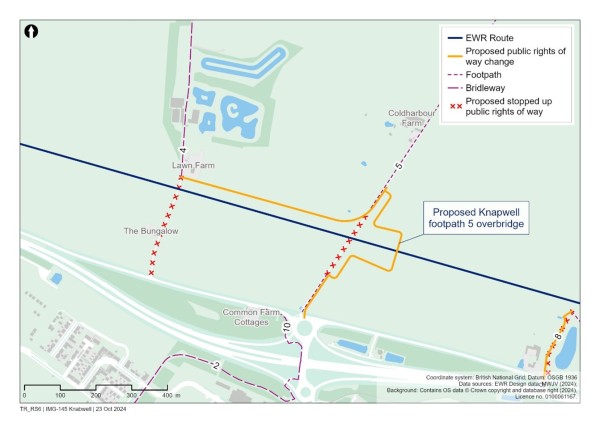
East of the passing loops and towards Cambourne station the railway would be close to ground level. Knapwell Footpath 8 would cross the railway via a new footbridge close to its existing route. A new footpath to the south of the railway would then link Knapwell Footpath 8 to Cambourne station.
14.6 Cambourne station
We would build a new station at Cambourne to support existing communities and proposed and potential new growth in the area. The new station would be located to the north of the town, the A428 and St Neots Road. We are continuing to work with partners including Greater Cambridge Shared Planning Service to understand how the design of the station can provide a good connection for the existing community at Cambourne, whilst also facilitating sustainable growth in the area which will benefit the existing community and the wider region. This includes considering the station location and access points, and integration with wider connectivity, such as the Cambourne to Cambridge busway promoted by the Greater Cambridge Partnership.
Cambourne station would include a station building to the south of the proposed railway, two platforms, a footbridge with stairs and lifts to provide step free access. It would include an active travel hub including cycling facilities, bus facilities and a car park. Vehicular access would be via St Neots Road and a new footbridge would be provided crossing over the A428 and St Neots Road and connecting into Cambourne.
Figure 66: Map showing Cambourne station proposals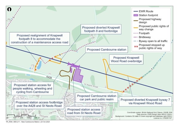
14.7 A428 Bourn Airfield crossing
East of Cambourne station and Knapwell Wood Road, the railway would drop into a cutting to enter a cut and cover tunnel that passes beneath:
- St Neots Road.
- The A428.
- Wellington Way.
- The proposed Cambourne to Cambridge busway.
- The north-east corner of the proposed Bourn Airfield development site.
- Highfields Road.
The tunnel would be approximately 1.5km (0.9 miles) long.
Our proposal to construct a tunnel for the A428 Bourn Airfield crossing follows consideration of a range of alternative options considered in response to concerns highlighted in feedback from our 2021 non-statutory consultation about the visual impacts of either a viaduct or embankments in this area. More information about this process can be found in Chapter 11 of the Technical Report.
A tunnel services building, housing operational and maintenance equipment, would be required at each end of the tunnel. The tunnel would also require an emergency escape route via shafts towards the middle of the tunnel within the northern side of the Bourn Airfield development site. Further information regarding the A428 Bourn Airfield crossing can be found in Chapter 11 of the Technical Report.
To reduce construction complexity and traffic disruption and to maximise programme efficiency, the A428 and St Neots Road would be temporarily realigned. There would also be a temporary localised diversion of Wellington Way and Highfields Road prior to constructing the tunnel beneath.
Construction traffic routes to support the construction of the tunnel would be strictly controlled and the most suitable route to the strategic road network (motorways and major A roads) would be used to reduce potential impacts to the local area. To build the tunnel, we would expect construction traffic would use the A428.
Two Pots Farm would be directly impacted by the cutting and tunnel construction and is expected to require demolition. We recognise the impact this would have and will be working with affected parties as the designs are further developed.
Figure 67: Map showing A428 Bourn Airfield proposals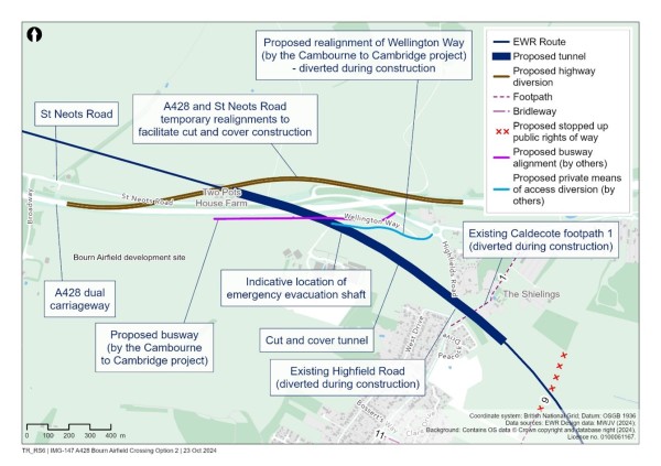
14.8 Hardwick to Toft
For approximately 5km (3.1 miles) between Hardwick and Toft the railway would be in a series of cuttings. It would emerge from the proposed tunnel in cutting approximately 12m (39 feet) deep.
Caldecote Footpath 9, which currently ends to the north of the proposed railway, would be stopped to the south, approximately 250m (273 yards) short of its current end point.
Continuing south, Hardwick Bridleway 5 (the Harcamlow Way/Wimpole Way long distance path) would cross the railway via a new footbridge while the railway remains in cutting. The new bridge would be approximately 2m (7 feet) above ground level and would be designed as a green bridge to allow for the continued movement of bats across the railway.
To cross Hardwick Road/Main Street, the railway would pass under a new road bridge that would be approximately 2m (7 feet) above ground level. To minimise disruption, we would keep the existing road open during construction by realigning it slightly to the west.
Between Toft and Comberton, the railway would be in cutting to cross beneath the B1046 Comberton Road. This road would cross over the railway on a new road bridge, which would be a green bridge to maintain a bat flight path across the railway. To reduce disruption on local roads, the new overbridge would be constructed slightly to the north of the existing highway, which would allow the existing road to remain open during construction.
14.9 Share your feedback
We would like to hear your feedback on our proposals for the Croxton to Toft route section. We are particularly interested in your views on:
- Issues and opportunities we should consider as we develop plans for the new Cambourne station.
- Issues and opportunities we need to consider as we develop our proposals for the railway in this section, including the A428 Bourn Airfield tunnel.
You can find details of how to respond to our consultation in the Have your say section of this Consultation Document.
15. Route section – Comberton to Shelford – construction of new railway and improvements to the existing railway
This section of the route runs from the B1046 Comberton Road to Addenbrooke’s Road, Shelford and is approximately 14.3km (8.9 miles) long.
This chapter covers:
- An overview of what we are proposing and why, including how proposals have developed since last year’s route update announcement.
- How we have considered the environment when developing our proposals.
- Specific proposals around:
- Comberton to Harlton.
- Harlton and Haslingfield.
- Harston and Hauxton Junction.
- Impact on level crossings, including Harston level crossing and Hauxton Road level crossing.
- Shepreth Junction.
- How to share your feedback using the feedback form.
15.1 What we are proposing and why
In this section, we are proposing to construct new railway lines between Comberton and Harston and improve the existing railway between Harston and Addenbrooke’s Road in Cambridge. This work will enable four new East West Rail services an hour to run through to Cambridge, from Oxford, Bletchley, Stewartby and Bedford. This will make it easier to travel around the region and beyond, reducing congestion and opening up new and easy commuting routes, which will increase access to employment and provide opportunities for businesses to expand along the route. The new station we would build at Cambourne would give local communities in this section an additional option for travel.
Work we have done since the route update announcement
The 2023 route update announcement confirmed our preference for the alignment in this area which runs between Comberton and Hauxton Junction. It also confirmed our preference to construct an offline, grade-separated junction to connect the new railway to the existing Shepreth Branch Royston Line. This design involves constructing a bridge or underpass to carry one line over the other.
In developing these designs, we have taken account of feedback from the non-statutory consultation in 2021 which expressed concern about the visual impacts of the new railway and the grade-separated junction. The feedback also explained the importance of maintaining connectivity between Harston and Newton. Our updated proposals seek to address these concerns.
Here’s what we are proposing for this section of the route, and why:
- We are planning to construct two new tracks between Comberton and Hauxton Junction east of the A10 Royston Road where they would join the existing railway.
- We are proposing the construction of a tunnel, bridges and crossings so that roads and footpaths can cross the railway including the A10 Royston Road diversion.
- At the Harston level crossing, we are looking at options how we can avoid separating the communities of Harston and Newton when the level crossing is closed, so that the connection between the villages can be maintained.
- We are considering what changes would be needed to the Shepreth Branch Royston Line and West Anglia Main Line to allow them to connect with East West Rail and to reduce possible disruption on the railway.
- At Hauxton Junction, we are planning the construction of passing loops to allow fast trains to overtake slower trains, including freight, to help avoid any delays.
- We are planning to construct river and stream crossings and two new viaducts over Bourn Brook to the south of Comberton and the River Rhee to the west of Harston, to enable the railway to travel through these areas.
- We are also proposing to construct balancing ponds and divert utilities including overhead electricity transmission lines.
Figure 68: Map showing Comberton to Shelford route section proposals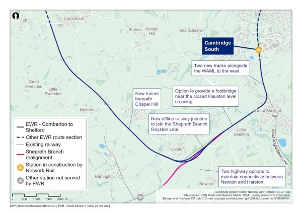
How we have considered the environment when developing our proposals
As we continue to develop our proposals for this section of East West Rail, we are thinking carefully about a number of environmental matters, including:
Landscape and visual impacts
- We will carry out a landscape and visual impact assessment to understand potential impacts, and will incorporate appropriate mitigation in our designs to reduce visual impacts as far as possible. A series of high embankments and viaducts between Comberton and Haslingfield and a viaduct crossing of the River Rhee, south-west of Harston, could potentially impact on existing views from residential properties, local roads and public rights of way.
- The proposed tunnel beneath Chapel Hill has been introduced in response to public feedback and would significantly reduce potential visual impacts compared to previous proposals.
Water resources
- Assessments will be undertaken to demonstrate that the project would not deteriorate the water quality and characteristics of water features. This includes where the proposed route crosses the river Granta, Bourn Brook and river Rhee and their tributaries – including Hobson’s and Coldham’s brooks – which are chalk streams.
- A Code of Construction Practice will be developed containing measures to mitigate potential impacts to water quality, groundwater and other features during construction. The draft Code of Construction Practice will be submitted as part of our DCO application.
Biodiversity and nature conservation
- Barbastelle bats are present in Eversden and Wimpole Woods and are known to commute and forage across this area. Maintaining connectivity and enhancing their foraging areas is a key consideration for the project design, including a tunnel in place of a cutting at Chapel Hill.
- Protecting important habitats in the area and the species they support is a key consideration. Suitable protective measures would be put in place during construction to avoid impacts to protected habitats and species.
Mullard Radio Astronomy Observatory
- The potential for electro-magnetic interference between the railway and the Mullard Radio Astronomy Observatory is being assessed. Suitable protective measures will be incorporated within the railway design.
Initial information about potential impacts and mitigation concepts in this route section are provided in Chapter 11 of the Environmental Update Report.
15.2 Comberton to Harlton
The railway would go under the B1046 to the east of Cambridge Meridian Golf Club and west of Comberton Village College in a cutting and remain in a cutting for approximately 600m (660 yards) to the south of Comberton. Toft Footpath 16 would cross over the railway on a new footbridge constructed over the cutting.
Emerging from the cutting south of the B1046, the railway would rise onto an embankment and continue over a new viaduct to cross over Bourn Brook. The railway would then remain on an embankment which would be constructed to a height of approximately 11m (36 feet) as it passes to the south-west of the Mullard Radio Astronomy Observatory.
Great and Little Eversden Footpath 26 would cross under the railway through an underbridge structure at existing ground level, with minimal diversion to the footpath.
North of Harlton, the railway would cross over the A603 Cambridge Road on a new bridge. Comberton Road and Washpit Lane would be slightly diverted and a new junction with the A603 created for each. A new access road off A603 Cambridge Road to the east of the railway would be created to maintain access to residential properties. The railway would then pass over Long Brook on a bridge.
Figure 69: Map showing Cambridge Road proposals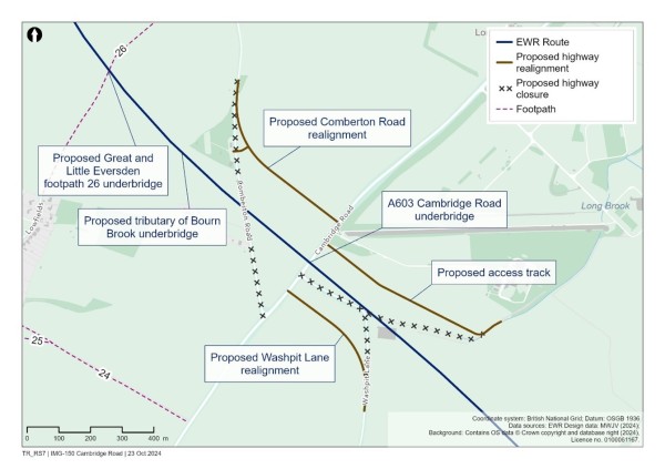
15.3 Harlton and Haslingfield
In this area the new railway would pass between the villages of Harlton and Haslingfield before crossing Chapel Hill.
The railway would continue on embankment from Long Brook before reducing in height to ground level and crossing under Harlton Road, which would be slightly realigned to the south on a new bridge.
We propose to construct a tunnel for the railway to pass through Chapel Hill. This would avoid having to construct a very large cutting, which would require significant construction works and could affect the flight paths of Barbastelle bats which live in the area. The tunnel would be approximately 700m (770 yards) long and have a maximum depth of approximately 26m (85 feet). Cuttings would be built at the approaches to the tunnel, and a tunnel services building, housing operational and maintenance equipment, would be required at each end of the tunnel. These would be located within the cutting to reduce their visual impact on the surrounding area.
Figure 70: Indicative illustration of Chapel Hill tunnel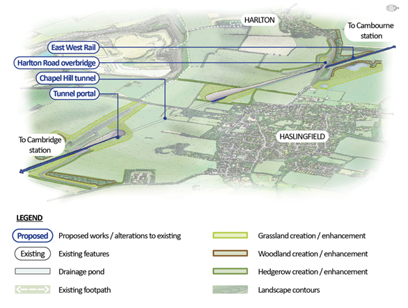
A range of alternative options to a tunnel were explored. Further details of the options we considered are set out in Chapter 12 of the Technical Report.
After the tunnel, the railway would rise onto an embankment as it passes south of Penn Farm and Charity Farm. A farm access track would be diverted under the railway at Thriplow Farm. The route would then cross the River Rhee on a viaduct, passing south of Harston Mill.
15.4 Harston and Hauxton Junction
We have looked at how we could connect the new railway to the existing Shepreth Branch Royston Line. A new railway junction would be required to allow East West Rail services to connect with the existing railway.
The new railway would continue around the southern edge of Harston joining the Shepreth Branch Royston Line as part of the proposed changes forming a new junction referred to as Hauxton Junction. These changes would involve the Shepreth Branch Royston Line being diverted over the East West Rail westbound lines. The eastbound East West Rail alignment would continue north and join the existing Shepreth Branch Royston Line just west of the M11 crossing.
Diverting the Shepreth Branch Royston Line over the East West Rail tracks would mean the existing Shepreth Branch Royston Line could remain open through most of the proposed construction period.
Two passing loops would be constructed as part of Hauxton junction, allowing faster passenger trains to overtake slower trains:
- The westbound passing loop would be located from south of Chapel Hill to Hauxton junction and join the Shepreth Branch Royston Line to the west of the existing M11 crossing.
- The eastbound passing loop would start approximately halfway between the existing Newton Road and London Road, joining the Shepreth Branch Royston Line again to the west of the existing M11 crossing.
When selecting a preferred option of the junction, we carefully considered ways to reduce the impact on the local area, including existing roads and consideration of environmental constraints like priority woodland habitats, heritage assets, flood zones, existing settlements and residential properties in Harston, Hauxton and Newton.
15.4.1 Impact on level crossings
All level crossings in close proximity to Hauxton junction on the Shepreth Branch Line would be closed. This includes:
- Harston and No.37 level crossings south of Harston.
- Hayes level crossing to the west of the junction.
- Hauxton Road and Rectory Farm level crossings to the east of the M11 motorway.
The proposals relating to these level crossings are described in more detail in the following sections.
15.4.1.1 Harston and No.37 level crossings
Harston level crossing and the No.37 level crossing would both need to be closed to accommodate the new rail infrastructure. The Harston level crossing is located on Newton Road which is the main road that connects Harston and Newton. The No.37 level crossing is between Newton Road and London Road on the Shepreth Branch Royston Line.
To avoid separating these communities as a result of the closure of Harston level crossing, we considered four options for a road diversion. The following two options are being taken forward, and we would like your feedback on them. Our emerging preferred option for the road diversion is Option 4. Further detail on the options we considered and the reasons for the emerging preference is set out in Chapter 12 of the Technical Report.
- Option 1 would divert Newton Road to the south-west of the existing road, passing over the Shepreth Branch Royston Line via a bridge in its new location, before heading west to join the realigned A10.
Figure 71: Indicative illustration of Hauxton Junction and Newton Road to the south-west of the route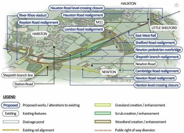
- Option 4 would provide a connection from Newton to Harston via London Road. North of the realigned highways overbridge, a new road connection would use the route of the former Shepreth Branch Line track to connect to Station Road, south of Harston. This would include an active travel route for pedestrians and cyclists.
Figure 72: Indicative illustration of Hauxton Junction and Station Road connecting the realigned London Road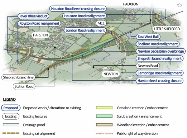
We are also actively considering providing a new accessible footbridge approximately 400m (437 yards) east of the existing Harston level crossing. This would provide an additional route for pedestrians and cyclists between Newton and Harston after Harston level crossing is closed. People who use No.37 level crossing would also be able to use this accessible footbridge. We will carry out further work to consider whether the footbridge should be provided, and will take account of your feedback before making a decision.
Figure 73: Map showing potential new accessible footbridge between Newton and Harston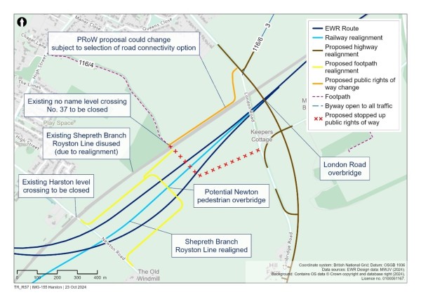
15.4.1.2 Hayes level crossing
Hayes level crossing, which is located to the west of the proposed Hauxton Junction, would be closed.
Depending on whether Option 1 or 4 is used to connect Newton and Harston, current users of Hayes level crossing would either be diverted to the realigned A10, or to Newton Road around the Shepreth Branch Royston Line.
15.4.1.3 Hauxton Road level crossing
The Shepreth Branch Royston Line passes beneath the M11 and continues just north of Little Shelford on its existing alignment. We propose closing Hauxton Road level crossing due to the increased number of trains that would pass over the crossing once East West Rail is operating.
An increase of four trains in each direction per hour, in addition to the Great Northern, Thameslink and freight trains that already run on the railway, would require the barriers to be down for up to 90% of the time during a standard timetabled hour. Even with improvements to the level crossing, this would not address traffic congestion caused by increased barrier down time.
We propose closing the level crossing and providing a new road bridge over the railway west of Little Shelford, linking High Street with Newton Road. Pedestrians, cyclists and other users of the existing crossing would also be able to use this road bridge.
In addition to the new road bridge, we are also considering providing a footbridge to the east of the level crossing which could be used by pedestrians, cyclists (dismounted) and others. Users would access it from the fields next to Hauxton Road. We would like your feedback during this consultation to help us decide whether the footbridge should be provided.
Figure 74: Map showing option to include a new footbridge at the closed Hauxton Road level crossing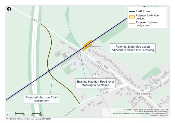
15.4.1.4 Rectory Farm level crossing
East of Little Shelford, the railway would continue along its existing route. A private level crossing for Rectory Farm would be closed. We will continue to talk with the affected landowner and users about how this would impact them and what diversions or alternatives might be suitable. There is an existing private footpath underpass just south of this level crossing which would not be impacted.
15.5 Shepreth Junction and West Anglia Main Line
North of Great Shelford, we are proposing to add two more tracks to the West Anglia Main Line to form a four-track corridor from Shepreth Junction into Cambridge. This would provide capacity for East West Rail services as the current twin-track West Anglia Main Line into Cambridge from Shepreth Branch Junction does not have the operational capacity required for current and future services. The additional tracks would be built to the west side of the West Anglia Main Line, and the existing Shepreth Junction would be remodelled.
Providing two new tracks to the west of West Anglia Main Line would require other infrastructure interventions including:
- The existing footbridge carrying Great Shelford Footpath 1 over the railway at Shepreth Junction would need to be replaced to create room for the railway.
- To accommodate the wider track corridor, a new balancing pond would be required southeast of Shepreth Junction. A new rail systems compound to house equipment supporting the widened railway would also be required at this location.
- Another balancing pond would be required south of the existing Addenbrooke’s Road overbridge crossing on the western side to account for the wider railway corridor.
- The underbridge at Nine Wells would need to be widened to accommodate two additional tracks.
Figure 75: Map showing infrastructure proposals along the West Anglia Main Line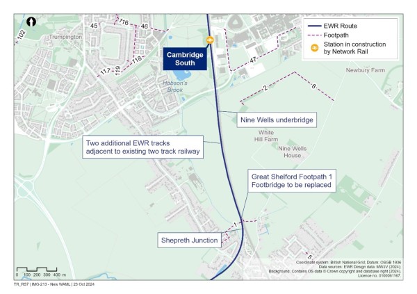
15.6 Share your feedback
We would like to hear your feedback on our proposals for the Comberton to Shelford route section. We are particularly interested in your views on:
- The options for maintaining connectivity between Harston and Newton after the closure of Harston level crossing, including whether a new footbridge should also be built.
- Whether we should build a new footbridge in addition to a road bridge to replace Hauxton Road level crossing.
- Any other issues and opportunities we need to consider as we develop our proposals for this section of the railway.
You can find details of how to respond to our consultation in the Have your say section of this Consultation Document.
16. Route section – Cambridge – improvements to the existing railway and stations
This chapter of the Consultation Document outlines our proposals for improvements to the existing railway and stations for the section of the route that would run from Addenbrooke’s Road bridge over the existing West Anglia Main Line, north of Great Shelford, to the A14 bridge north of Cambridge North station, and to Yarrow Road in Cherry Hinton to the East of Cambridge on the Newmarket line. This section of the route covers approximately 8km (5 miles).
This chapter covers:
- An overview of what we are proposing and why, including how our proposals have developed since last year’s route update announcement.
- How we have considered the environment when developing our proposals.
- Specific proposals covering:
- Proposals for two new tracks on the West Anglia Main Line approaching Cambridge.
- Cambridge South station.
- A new Long Road overbridge.
- Cambridge station, including a new platform.
- Proposals for a turnback siding east of Cambridge station, which would avoid the need for major disruptive work at Cambridge station.
- How to share your feedback using the feedback form.
16.1 What we are proposing and why
In this final section of the new railway, East West Rail would connect to Cambridge, improving access to all the city has to offer for people across the region, including jobs, education and days out.
Today, journeys between Bedford and Cambridge take 50 to 75 minutes by road and two hours by train, via London. East West Rail would reduce this journey time to just 35 minutes and help relieve congestion in the city, making it easier for people to get to work and for businesses to have the confidence to expand and create more jobs.
It would also bring more locations within easy reach of good jobs in the city, so that families could choose to live more affordably elsewhere along the East West Rail route, rather than being forced to pay premium prices to live closer to work. For example, four trains an hour would stop at Cambourne station, where it would then take just 15 minutes to travel into Cambridge.
By improving connections to Cambridge, East West Rail would also make it easier for businesses to access a wider labour market and to choose to locate or expand elsewhere in the region. This would create high quality jobs in other areas along the railway line where there is a skilled workforce, affordable space and other good transport connections – all whilst still having good proximity to Cambridge. It could also enable a cluster of businesses to form to the west of Cambridge enabled by East West Rail stations at Cambourne and Tempsford, spreading opportunity and prosperity across the region.
How our proposals for Cambridge have developed
During the 2021 non-statutory consultation, we shared our preference for East West Rail to approach Cambridge from the south and we asked for your views on this. We then considered this feedback and carried out further technical and environmental work. At the route update announcement in 2023 we confirmed our preference for a southern approach and to integrate with the new Cambridge South station being developed by Network Rail.
We believe this is the best option for the city, the region and the whole of the UK. There are three times as many jobs within walking distance of Cambridge South station compared to Cambridge North station, including at the Cambridge Biomedical Campus, the city’s largest employment site, which is an unparalleled centre for life sciences. The existing transport network is also more congested in the south, making it more difficult for employees to commute from other towns, and limiting further job creation there. As a result, the southern approach would be more likely to unlock the region’s potential for transformational economic growth and create jobs, attract investment and support the UK economic recovery.
Work we have done since the route update announcement
Following the route update announcement, we have continued to develop designs for this section of the route. We are now also proposing works to the existing railway north of Cambridge station, at Cambridge North station and to a section of the Newmarket Line running east. These works provide a better solution for bringing East West Rail services into Cambridge station than the design set out at the route update announcement.
More information on the proposal for Cambridge can be found in the Chapter 13 of the Technical Report.
Figure 76: Map showing Cambridge route section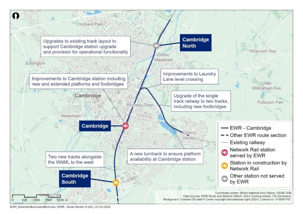
Here’s what we are proposing for this section of the route, and why:
- To make sure there are enough railway tracks to accommodate the new East West Rail services, we are planning to lay two new railway tracks next to the existing two-track West Anglia Main Line on its western side from Addenbrooke’s Road. These would join the existing four tracks at the new Cambridge South station (currently being constructed by Network Rail), and continue into Cambridge station.
- We are proposing to demolish the overbridge at Long Road and provide a new bridge wide enough to fit the railway underneath.
- At Cambridge station, we are planning a new platform, platform extensions, bridges, building upgrades and railway systems modifications – all to give passengers the best possible experience.
- At the existing level crossing at Laundry Lane, we are planning safety improvements that are needed as a result of the planned increase in train speeds and the addition of a track in this area.
- At Cherry Hinton, we are proposing a new train turnback facility so that East West Rail passengers can alight at Cambridge station and trains can continue to Cherry Hinton to turn around. This would avoid the need for trains to turn around at Cambridge where there is currently insufficient platform capacity to accommodate both existing and new East West Rail services.
- We are planning to reconstruct two footbridges at Coldham’s Common and The Tins footpath to allow for electrification of the railway and the addition of a second track.
- We are considering where to locate two railway sidings that will be lost due to the proposed works at Cambridge station. The two emerging possible locations for these are Chesterton sidings at Cambridge North station.
- At Cambridge North station, we are planning to modify the track layout to allow for some existing train services from the north to terminate there during our construction works at Cambridge station.
How we have considered the environment when developing our proposals
As we continue to develop our proposals for this section of East West Rail, we are thinking carefully about a number of environmental matters, including:
Landscape and visual impacts
- The new pedestrian/cycle bridge on Coldham’s Common would be a more prominent visual feature. We will carry out a landscape and visual impact assessment to understand these impacts and how we can design the bridge to reduce these as far as possible. The removal of screening vegetation could result in potential visual impacts from Coldham’s Common and Cherry Hinton during construction.
Land use and open space
- Measures to mitigate any impacts on open space will be developed, which may include the provision of enhanced or replacement land where necessary. Open space and common land may need to be used at Coldham’s Common, Stourbridge Common, Darien Meadow and Ditton Meadows.
Water resources and flood risk
- Detailed modelling will be undertaken to assess flood risk and design appropriate mitigation. Assessments of the proposed crossings of the River Cam, Hobson’s Brook and Cherry Hinton Brook will be undertaken to ensure the works do not deteriorate the water quality and characteristics of these features.
Historic environment
- Cambridge station is a Grade II listed building. The proposed works will be designed sympathetically with a full understanding of the station’s architectural importance and history.
Noise and vibration
- The biomedical campus accommodates vibration-sensitive facilities, including the Microbiological Research Centre laboratory and the Anne McLaren Building. The noise and vibration from trains passing these facilities is an important focus of our ongoing assessment.
Initial information about potential impacts and mitigation concepts in this route section are provided in Chapter 12 of the Environmental Update Report.
16.2 Approaching Cambridge
To accommodate the new East West Rail trains, we are proposing to install two new tracks on the west side of the existing West Anglia Main Line from Shepreth Junction.
From where the railway crosses beneath Addenbrooke’s Road, the two new tracks would continue on the western side of the West Anglia Main Line through Cambridge South station, currently under construction by Network Rail. It would then continue under Long Road and Hills Road and connect into the existing four-track arrangement south of Cambridge station.
16.3 Cambridge South station
Cambridge South station is currently under construction by Network Rail. The two new East West Rail tracks would tie-in with the planned station layout. Some minor changes to the new station may be required to accommodate East West Rail services.
16.4 Long Road overbridge
The addition of the two new tracks to the West Anglia Main Line means that the bridge at Long Road would need to be widened to allow four tracks to pass under it. To do this, we would need to demolish the existing bridge at Long Road and build a new, longer bridge to span the proposed four tracks.
Temporary access across the busway, which runs parallel to the west of the West Anglia Main Line, would be needed to allow the bridge to be reconstructed and for associated railway works.
16.5 Cambridge station
With the introduction of East West Rail services, Cambridge station would receive four new passenger trains per hour. At the moment, the station doesn’t have the capacity to accommodate this increase in trains and passengers, so we would need to make some changes to Cambridge station including:
- Extending existing platforms.
- Building a new accessible platform.
- Creating new facilities for East West Rail.
We have refined our station proposals to reduce the complexity of works and the amount of new platform space needed. We propose to build a new platform 9 on the eastern side of the station, with platforms 7 and 8 being extended at both ends. Additional rail infrastructure (track, signaling and other rail systems) would also be needed.
East West Rail trains would stop at Cambridge station allowing passengers to alight. Instead of remaining at the platform to prepare for the return journey, the empty trains would continue along the existing Newmarket Line to the north-east of the station to a new turnback facility which would be constructed along this section of existing railway. This means trains would not have to spend as long waiting at the platform in Cambridge station.
We would also need to make changes to the station building to accommodate the increase in passengers from the new East West Rail services. These changes would be designed sympathetically, in line with the station’s Grade II listed status. The station concourse would be upgraded. Other changes would include extending the existing footbridge to serve the new platform 9, relocating staff areas for train crew and other operators, and building two new footbridges for passenger use and emergency evacuation.
Figure 77: Indicative illustration of our proposed changes at Cambridge station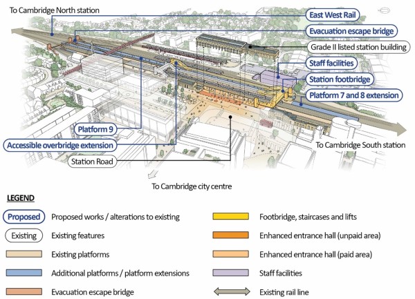
16.5 East of Cambridge station
We have investigated a range of options that would avoid the need for major disruptive work at Cambridge station. We have considered options to enable trains to turn back beyond Cambridge station, which would remove the need for East West Rail trains to occupy platforms for an extended period of time.
Our preferred approach involves delivering a turnback siding beyond Cambridge, either on the West Anglia Main Line or on the route towards Newmarket. This is explained in the Cherry Hinton turnback section of this chapter.
We are aware that some stakeholders have identified potential for a new station to the east of Cambridge on the line to Newmarket. We do not currently propose to deliver a station at Cambridge East and this is not included in our designs for this consultation. However, we recognise the wider opportunity this could present, including supporting wider growth and opportunities for local people in this area of Cambridge.
Third-party funding would be required to take forward a scheme in this area. Accordingly, we welcome views from respondents on the opportunity to deliver a station on the Newmarket Line in the Coldham’s Lane area.
16.6.1 Cherry Hinton turnback
To provide a new train turnback facility (providing additional capacity for trains to change direction) east of Cambridge station, we are proposing to lay an additional track to the existing section of the Newmarket Line from Coldham’s Lane junction to the turnback locations. This would reduce the time trains need to remain at Cambridge station.
Our proposals involve:
- Upgrading Laundry Lane level crossing to accommodate the introduction of the additional track.
- Realigning the existing track in several locations to accommodate the new additional track, largely within the existing rail corridor.
- Reconstruction and widening of the Coldham’s Common and The Tins pedestrian bridges to accommodate the additional track and provide sufficient clearance for potential overhead electrification of the railway to the turnback location.
At this stage Cherry Hinton is our preferred location for a turnback facility, but we are continuing to look at other possible locations in and around Cambridge to see if these could reduce both costs and potential environmental impacts. We will present final proposals at the statutory consultation.
16.6.2 Laundry Lane level crossing
The current crossing at Laundry Lane has an automatic barrier. Trains currently pass through this area at a speed of 10mph. The addition of one new track and proposed speed increase of trains from 10mph to 25mph mean we would need to carry out upgrades to the crossing including signalling improvements to reduce safety risks.
16.6.3 Footbridge modifications
Two footbridges along this section of the line, one on Coldham’s Common and one on The Tins footpath, would be reconstructed to allow for electrification of the railway and the addition of a second track. These works would require a temporary construction compound to be located on Coldham’s Common. Further details regarding the temporary compound can be found in Chapter 13 of the Technical Report.
Figure 78: Map showing proposed changes on the Newmarket Line including a turnback at Cherry Hinton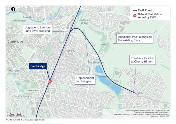
16.7 North of Cambridge station
16.7.1 Cambridge North station
Work is proposed at Cambridge North station to modify the track layout. This would support the delivery of the modifications to Cambridge station and provide a potential location for some replacement sidings after they are removed at Cambridge station. The new layout would also provide the flexibility to allow services to terminate at Cambridge North station should this be decided in the future.
16.7.2 Sidings
The construction work required to improve Cambridge station would lead to two railway sidings being relocated. We are currently in discussions with Network Rail, train operating companies and freight operating companies to consider locations within existing railway land which could be used for replacement sidings. Further details on potential locations can be found in Chapter 13 of the Technical Report.
An emerging possible location is Chesterton sidings at Cambridge North station. At Cambridge North station, locations for two new sidings have been identified to the west of the station and a third one to the north of the station.
16.8 Share your feedback
We would like to hear your feedback on our proposals for the Cambridge route section. We are particularly interested in your views on:
- Our proposals for two new tracks on the approach to Cambridge station.
- Our proposals for new and extended platforms and new facilities at Cambridge station.
- Our proposals for sidings north of Cambridge station.
- Our proposals for works at Cambridge North station.
- Our proposals for the Newmarket line with a turnback at Cherry Hinton.
You can find details of how to respond to our consultation in the Have your say section of this Consultation Document.
17. Next steps for the design
This consultation presents our proposals for the project. In some areas of the route, this includes alternative options on which we are seeking feedback. The outcome of ongoing design development and our decisions on the options presented will be reported at the statutory consultation.
We will continue to refine and optimise our design proposals, with a focus on sustainability and mitigation of potential environmental effects, cost reduction, constructability and reducing impacts on traffic and transport. Examples of this ongoing design development include:
- Refinement of the alignment and height of the railway to reduce the amount of material that may need to be imported or disposed of.
- An evaluation of public rights of way diversions to determine if better ways of maintaining connectivity can be achieved.
- Using the results of the ongoing environment assessment to further develop mitigation proposals.
- Using updated surveys and the results of traffic and transport modelling data to develop the proposals.
- Using architectural input to key design elements such as stations and viaducts to ensure they fit within their local surroundings.
- Further integration of our proposals with Local Plans and other developments to help design active travel and door-to-door connectivity measures.
We recognise the value of good design as an essential part of this process. In developing our proposals we will follow good design principles and take account of the four design principles (climate, people, places and value) produced by the National Infrastructure Commission.
18. How to get involved
18.1 Consultation events
We are holding a series of consultation events across the route. At each event, you can see how our proposals have evolved, talk with members of our team, ask questions and submit your feedback.
Visit a consultation event near you. In-person events will take place from 2-7pm on weekdays and 12-5pm on weekends at the locations below.
Table 4: Consultation event locations and dates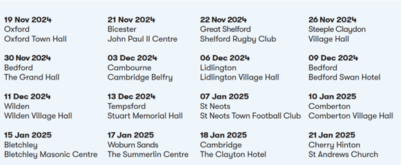
18.2 Online events
We are hosting three online consultation events. If you are unable to attend an event in person, these will give you a chance to understand more about the proposals and ask questions of the team.
- Wednesday 20 November 2.30-4.40pm
- Tuesday 10 December 6-8pm
- Thursday 9 January 10am-12pm
Information how to register for the online events can be found on the East West Rail website at eastwestrail.co.uk
18.3 Information points
The following printed consultation material will be available to view at information points along the route during the consultation:
- Consultation
- A guide to the Consultation Document.
- Technical Report.
- Relevant maps and plans.
- Environmental Update Report.
- Feedback forms and freepost envelopes (available to take away).
Table 5: Information points
|
Venue |
Address |
|
Aylesbury Library |
Aylesbury, HP20 1UU |
|
Bedford Central Library |
Harpur Street, Bedford, MK40 1PG |
|
Bicester Library |
Franklins House, Wesley Lane, Bicester, OX26 6JU |
|
Bletchley Library |
Westfield Road, Milton Keynes, MK2 2RA |
|
Cambourne Library |
Sackville House, Sackville Way, Cambridge, CB23 6HL |
|
Cambridge Central Library |
7 Lion Yard, Cambridge, CB2 3QD |
|
Rock Road Library |
To be added |
|
Barnwell Road Library |
To be added |
|
Cambridge University Medical Library (Biomedical Campus) |
School of Clinical Medicine, Hills Rd, Cambridge CB2 0SP |
|
Cherry Hinton Library |
High St, Cherry Hinton, Cambridge CB1 9HZ |
|
Comberton Library |
West St, Comberton, Cambridge CB23 7DU |
|
Great Shelford Library |
10-12 Woollard's Lane, Cambridge, CB22 5LZ |
|
Haslingfield Village Shop |
2 Fountain Ln, Haslingfield, Cambridge CB23 1LT |
|
Huntingdon Library & Archives |
Princes St, Huntingdon PE29 3PA |
|
Kidlington Library |
23 Oxford Road, Kidlington, OX5 2BP |
|
King’s House |
245 Ampthill Rd, Bedford MK42 9AZ |
|
Little Acorn Cafe |
33 High St, Roxton, Bedford MK44 3EA |
|
Milton Keynes Central Library |
555 Silbury Boulevard, Milton Keynes, MK9 3HL |
|
Oxford Westgate Library |
2 Westgate, Oxford, OX1 1PE |
|
North Oxford Association Community Centre |
Diamond Place, Summertown, Oxford OX2 7DP |
|
Ridgmont Station Vintage Tea Room & Heritage Centre |
Station Road Ridgmont Railway Station, Ridgmont MK43 0XP |
|
Steeple Claydon Library |
48 Queen Catherine Road, Buckingham, MK18 2PY |
|
St Neots Library |
Priory Ln, St Neots, Saint Neots PE19 2BH |
|
The Forest Centre & Millennium Country Park |
Station Rd, Marston Moretaine, Bedford MK43 0PR |
|
Winslow Community Library |
Park Road, Winslow, MK18 3DL |
|
Woburn Sands Library |
64 High Street, Woburn Sands, MK17 8SD |
|
Wootton Library |
Lorraine Road, Wootton, MK43 9LH |
|
Cambridge University Library |
To be added |
18.4 Find out more

|
Visit our website (eastwestrail.co.uk) |
You can find the full range of consultation material in accessible and downloadable formats. You’ll also find information on how you can respond to this consultation and further details about East West Rail.
|
|
|
Get in touch |
You can always get in touch with a member of our team by calling 0330 134 0067 or emailing [email protected] .If you or anyone else would prefer consultation material in a different format or language, please let us know by emailing [email protected] or calling the number above. |
19. How to respond to this consultation
We know that you have local knowledge of your area, such as how traffic moves around, the key journeys people need to make, what is important about your environment, future areas of development and how the emerging proposals may directly impact your properties and lives. Your feedback will help us to:
- Better understand the potential local effects of the project.
- Tackle issues at an early stage.
- Shape our proposals in ways which maximise community benefit.
- Decide which options to take forward.
- Look at ways to reduce potential negative impacts and to enhance positive opportunities.
19.1 Have your say
This is your opportunity to have your say on the proposals. You can respond to the consultation by:
- Completing the consultation feedback form online at eastwestrail.co.uk/feedback
- Emailing a copy of the feedback form to [email protected]
- Sending a copy of the feedback form to Freepost EAST WEST RAIL.
- Handing in a copy of the feedback form at a consultation event.
Your feedback will be used to help inform our continued development of the design, which we will present at the statutory consultation.
For further information or to request a paper copy of the feedback form to be sent to you, speak to the team by emailing us at [email protected] or by calling us on 0330 134 0067.
Please make sure you share your feedback with us before the closing date of 23:59 on Friday 24 January 2025.
19.2 Accessibility
We want everyone to be able to take part in this consultation. It is important that everyone living in the communities East West Rail would serve gets the opportunity to share feedback. That's why key materials will be made available in accessible formats. If you or anyone else would prefer consultation material in a different format or language, please let us know by emailing [email protected] or calling us on 0330 134 0067.
19.3 Data protection
All personal information received as part of this consultation will be handled in accordance with our privacy policy which can be found at https://eastwestrail.co.uk/privacy-at-ewr-co
As set out in the Planning Inspectorate Advice Note Fourteen in relation to compiling the Consultation Report, copies of any or all statutory consultation responses may be requested by the Planning Inspectorate to assist in assessing whether the duty to have regard to consultation responses has been met.
Any person responding should therefore assume that any response to consultation will be shared with the Planning Inspectorate and the Examining Authority and, under redaction of personal details by EWR Co, will be included in an appendix to the Consultation Report which will be published on the Planning Inspectorate’s website.
If you give us personal information about other people you must first make sure that you have obtained all necessary permission from that person for you to pass this information on to us.
20. List of consultation materials
We have produced the following material to give you the information you need to respond to this consultation, including:
- This document, the Consultation Document, provides an overview of our proposals and the benefits they would bring. It also explains how you can give feedback.
- A Guide to Consultation, providing guidance on how to navigate the Consultation Document and respond.
- An Environmental Update Report providing a qualitative assessment of initial environmental information.
- A Technical Report setting out more detailed information on our proposals and how they have been developed.
- Transport Update Report which contains initial information about the potential transport impacts from the project and the Transport Assessment Scoping Report.
- Route section
- Drawings showing the proposed railway from the top and side.
- A feedback form which will be available in both paper and online versions.
- Factsheets.
- Frequently Asked Questions (FAQs).
21. Glossary
|
Abbreviations |
Description |
|
ACP |
Affordable Connections Project |
|
ALARP |
As low as reasonably practicable |
|
ALC |
Agricultural Land Classification |
|
AIL |
Abnormal Indivisible Load |
|
AQMA |
Air Quality Management Area |
|
BAT |
Best Available Techniques |
|
BMV |
Best and Most Versatile Land (ALC Grade 1, Grade 2 and Grade 3a) |
|
BNG |
Biodiversity Net Gain |
|
BS |
British Standard |
|
CEMP |
Construction Environmental Management Plan |
|
CoCP |
Code of Construction Practice |
|
DCO |
Development Consent Order |
|
DEFRA |
Department for Environment, Food and Rural Affairs |
|
DfT |
Department for Transport |
|
DLUHC |
Department for Levelling Up, Housing and Communities |
|
EAL |
Environment Assessment Level |
|
ECML |
East Coast Main Line |
|
EIA |
Environmental Impact Assessment |
|
EPS |
European Protected Species |
|
EqIA |
Equality Impact Assessment |
|
EWR |
East West Rail |
|
EWR Co |
East West Rail Company |
|
FRA |
Flood Risk Assessment |
|
GHG |
Greenhouse Gas |
|
GTR |
Govia Thameslink Railway |
|
HA |
Heritage Asset |
|
HPI |
Habitats of Principal Importance |
|
HRA |
Habitats Regulations Assessment |
|
HS2 |
High Speed 2 |
|
IDB |
Internal Drainage Board |
|
LCA |
Life Cycle Assessment |
|
LDP |
Local Development Plan |
|
LLFA |
Lead Local Flood Authorities |
|
LNR |
Local Nature Reserve |
|
LNWR |
London and North Western Railway |
|
LPA |
Local Planning Authority |
|
LRG |
Local Representative Group |
|
MVL |
Marston Vale Line |
|
NERCA |
Natural Environment and Rural Communities Act |
|
NIC |
National Infrastructure Commission |
|
NNNPS |
National Networks National Policy Statement |
|
NNR |
National Nature Reserve |
|
NO2 |
Nitrogen dioxide |
|
NPPF |
National Planning Policy Framework |
|
NPS |
National Policy Statement |
|
NR |
Network Rail |
|
NSIP |
Nationally Significant Infrastructure Project |
|
NSRs |
Noise Sensitive Receptors |
|
ORR |
Office of Road and Rail |
|
PEA |
Preliminary Ecological Appraisal |
|
PEI |
Preliminary Environmental Information |
|
PEIR |
Preliminary Environmental Information Report |
|
SAC |
Special Area of Conservation |
|
SPA |
Special Protection Area |
|
SPI |
Species of Principal Importance |
|
SPZ |
Source Protection Zone |
|
SSSI |
Site of Special Scientific Interest |
|
TOC |
Train Operating Company |
|
TWAO |
Transport and Works Act Order |
|
WAML |
West Anglia Main Line |
|
WCML |
West Coast Mainline |
|
WFD |
Waste Framework Directive |
|
ZoI |
Zone of Influence |
|
ZTV |
Zone of Theoretical Visibility |
Definitions and Glossary
Definitions
|
Term |
Definition |
|
|
A428 Improvement Scheme |
The scheme developed by National Highways to upgrade the A428 between Black Cat roundabout east of Bedford and Caxton Gibbet roundabout west of Cambourne. |
|
|
Abnormal Indivisible Load (AIL) |
A vehicle that has any of the following: a weight of more than 44,000 kilograms, an axle load of more than 10,000 kilograms for a single non-driving axle and 11,500 kilograms for a single driving axle, a width of more than 2.9 metres, a rigid length of more than 18.65 metres, and which cannot be broken down into smaller loads for the purposes of transportation. |
|
|
Active Travel |
Making journeys in physically active ways - like walking, wheeling (using a wheelchair or mobility aid), cycling, scootering or riding a horse. |
|
|
Adaptive capacity |
Ability of systems, institutions, humans, and other organisms to adjust to potential damage, to take advantage of opportunities, or to respond to consequences. In the context of EWR this is typically in relation to adaptation to climate change. |
|
|
Affected Party |
An individual or organisation which has a land interest identified under Category 1 or Category 2 (Section 44 of the Planning Act 2008) in the Book of Reference, which will be subject to compulsory acquisition under the DCO. |
|
|
Affordable Connections Project |
A review of the strategic need for the project and to investigate solutions which could deliver the majority of the original project benefits and outcomes at a lower cost in 2021. |
|
|
Agricultural Land Classification (ALC) |
A framework for determining the physical quality of the land at national, regional and local levels. Land is classified into one of five grades, from Grade 1 (excellent quality) to Grade 5 (very poor quality). Grade 3, which constitutes about half of the agricultural land in England and Wales, is divided into Subgrades 3a and 3b. Grades 1, 2 and 3a are together described as best and most versatile (BMV) land. Grades are based on the long-term physical limitations of land for agricultural use. There are a number of factors that affect the grade, and the main ones are climate, site and soil characteristics, and the interactions between them. |
|
|
Air Quality Management Area (AQMA) |
An area designated by a local authority, where Air Quality does not meet the Air Quality Objectives without additional interventions. |
|
|
Ancient Woodland |
Any area of land that has been wooded continuously since at least 1600 AD. Ancient Woodland is regarded as irreplaceable habitat and is protected under the National Planning Policy Framework. Ancient Woodland is sub-classified as ancient semi-natural woodland and plantations on Ancient Woodland sites. |
|
|
Applicant |
East West Railway Company Limited (EWR Co) being the organisation preparing and submitting the DCO Application. |
|
|
As Low As Reasonably Practicable (ALARP) |
‘ALARP’ is short for ‘as low as reasonably practicable’ (see also SFAIRP). ‘Reasonably practicable’ involves weighing a risk against the trouble, time and money needed to control it. The Health and Safety Executive expects to see the principle of ALARP applied to the management of workplace risks. ‘SFAIRP (So Far as is Reasonably Practicable) is the term most often used in the Health and Safety at Work, etc. Act and in Regulations. However ALARP can apply to all business risk. ALARP is the term used by risk specialists, and duty-holders are more likely to know it. In HSE’s view, the two terms are interchangeable except if you are drafting formal legal documents when you must use the correct legal phrase. |
|
|
Assessment Factors |
The factors used to assess and compare different options for the project. |
|
|
At-grade Junction |
A railway or highways junction where tracks cross at the same level. Also known as a flat junction. |
|
|
Authorised Development |
The development for which development consent will be sought. It will be described in Schedule 1 to the draft Development Consent Order (DCO). This is also referred to as the project. |
|
|
Baseline (environment) |
A reference level of existing conditions at a fixed point in time against which any future changes can be measured or predicted and assessed and against which the project is measured and controlled. |
|
|
Best and Most Versatile Agricultural Land (BMV) |
See Agricultural Land Classification (ALC). |
|
|
Best Available Techniques (BAT) |
The available techniques which are the best for preventing or minimising emissions and associated impacts on the environment. |
|
|
Biodiversity Net Gain (BNG) |
An approach to development that aims to create and improve natural habitats to ensure a development has a measurably positive impact (‘net gain’) on biodiversity, compared to what was there before development. |
|
|
Blight |
The term blight used in this document refers to generalised blight. Generalised blight is typically used to describe the actual or assumed depreciation in value of property which may be attributable to a proposed infrastructure scheme. |
|
|
Blockade |
The closure of a rail route for an extended period (typically more than two to three days). |
|
|
Book of Reference |
A document that sets out all of the land directly affected by the project, as well as the owners and occupiers of the affected land and those with an interest in it (defined as Category 1, 2 and 3 under section 44 of the Planning Act 2008). This document will be submitted with the DCO application. |
|
|
British Standard |
The specification of recommended procedure, quality of output, terminology, and other details, in a particular field, drawn up and published by the British Standards Institution. |
|
|
Cambridge-Milton-Keynes Oxford Corridor |
A region defined by the Government and the National Infrastructure Commission covering local authorities across the counties of Northamptonshire, Cambridgeshire, Hertfordshire, Buckinghamshire and Oxfordshire and the unitary authorities of Bedford, Central Bedfordshire, Luton, Swindon and Milton Keynes. |
|
|
Cancellations and Significant Lateness |
The number and percentage of passenger trains which are cancelled in part or full, or which arrive at their final destination 30 or more minutes later than the time shown in the public timetable. |
|
|
Capital Cost |
Cost incurred during delivery of a project in purchasing buildings, land, construction works, and equipment as opposed to the costs of operating, maintaining or decommissioning the project. |
|
|
Carbon dioxide equivalent (CO2e) |
A carbon dioxide equivalent or CO2 equivalent, abbreviated as CO2e is a metric measure used to compare the emissions from various greenhouse gases on the basis of their global-warming potential (GWP), by converting amounts of other gases to the equivalent amount of carbon dioxide with the same global warming potential. CO2e is the standard unit for measuring carbon footprints. |
|
|
Carbon sequestration |
Refers to the capture of carbon dioxide (CO2) from the atmosphere, for example by trees. |
|
|
Capital Carbon |
GHG emissions associated with the creation, refurbishment and end of life treatment of assets. |
|
|
Operational carbon |
GHG emissions associated with the operation of assets to deliver the EWR service. |
|
|
Chainages |
General term used to describe linear measure. (The term is equally used in Imperial or metric units.) |
|
|
Circular Economy |
Economy that is restorative and regenerative by design, and which aims to keep products, components and materials at their highest utility and value at all times, distinguishing between technical and biological cycles. |
|
|
Climate Change Adaptation |
The process of adjusting to the effects of climate change, with the aim of reducing the negative impacts, and exploiting any opportunities. Adaptation measures include aspects such as design standards, operating procedures, asset maintenance and replacement, alternative products and materials etc. Climate resilience measures are strongly aligned to climate change adaptation, but also refer to current climate. |
|
|
Climate Change Mitigation |
Actions taken to reduce Greenhouse Gas (GHG) emissions, or remove them from the atmosphere, to limit global temperature rise. |
|
|
Code of Construction Practice (CoCP) |
A document that sets out relevant controls, standards and best practice measures that the project will implement to reduce the risk of adverse environmental impacts during the construction phase. A draft version will be submitted as part of the DCO application, and its implementation will be secured by requirements included in the DCO. |
|
|
Compensatory Floodplain Storage |
A mitigation measure that seeks to replicate the hydraulic function of a floodplain into which a development has encroached (and displaces floodwater during a flood event), offsetting potential flood risk impacts to surrounding receptors. |
|
|
Competent Authority (in the context of the Habitats Regulations) |
The relevant Secretary of State (SoS) is the Competent Authority for the purposes of the Habitats Directive and the Habitats Regulations in relation to applications for Nationally Significant Infrastructure Projects (NSIPs). A Competent Authority is responsible for undertaking the Habitats Regulations Assessment informed by information provided by the Applicant. |
|
|
Compulsory Acquisition |
The power of government to acquire ownership, possessory and controlling rights in land, even without the willing consent of land owner or occupant. It is commonly associated with the transfer of ownership of land. |
|
|
Conservation Area |
An area of notable architectural or historic interest or importance designated by the local authority in relation to which change is managed by the duties set out in the Planning (Listed Buildings and Conservation Areas) Act 1990. |
|
|
Construction Compound |
A secure area from which site work is managed and resourced, including but not limited to temporary offices, workshop, parking and storage during the construction phase of the project. |
|
|
Construction Environmental Management Plan (CEMP) |
A working document that defines how the Principal Contractor will specifically apply generic measures set out in the CoCP to mitigate potential impacts on the environment and local community during the construction phase. |
|
|
Construction Phase |
The stage during which construction works for the project will take place. This includes commissioning, when trains and facilities are being tested, but prior to passenger services starting. |
|
|
Contaminated Land |
Where substances are causing or have a significant possibility to cause significant harm to people, property or protected species; or, where significant pollution is being caused or has a significant possibility of being caused to controlled waters. |
|
|
Cumulative (environmental) Effect |
In the context of the EIA for the project a cumulative effect (sometimes also called an inter-project effect) is one that arises as a result of impact(s) from EWR together with those from other unrelated schemes. This is distinct from a combined effect (or intra-project effect). |
|
|
Cutting |
A passage that has been dug through high ground for a railway or road. The resulting form is either sloped earthworks down to the railway/road or some form of retaining measure. |
|
|
Customer |
A Customer is defined as one of the following: (a) Passenger. (b) Non-travelling person interacting with EWR services, facilities or infrastructure. (c) Communities along the route throughout the programme. (d) Freight services. (e) Engineering or maintenance services. (f) Special services. |
|
|
DCO Application |
The application for a Development Consent Order (DCO) that will be submitted by the applicant to the Planning Inspectorate to be examined on behalf of the Secretary of State (SoS) for Transport. |
|
|
Decommissioning Phase |
The stage during which decommissioning of the project would take place to take it out of use, following the operational phase. |
|
|
Degree of Change |
A combination of scale, extent and duration of an effect also defined as magnitude. |
|
|
Department for Environment, Food & Rural Affairs (Defra) |
UK Government department responsible for safeguarding our natural environment, supporting our world-leading food and farming industry, and sustaining a thriving rural economy. |
|
|
Department for Levelling Up, Housing and Communities (DLUHC) |
UK government department responsible for responsible for housing, communities, local government in England and the levelling up policy. Formerly Ministry of Housing, Communities & Local Government (MHCLG). |
|
|
Department for Transport (DfT) |
Government department responsible for the English transport network and a limited number of transport matters in Scotland, Wales and Northern Ireland that have not been devolved. |
|
|
Designated Heritage Asset |
A World Heritage Site, Scheduled Monument, Listed Building, Protected Wreck Site, Registered Park and Garden, Registered Battlefield or Conservation Area designated under the relevant legislation. |
|
|
Designated Landscape |
Areas of landscape identified as being of importance at international, national or local levels, either defined by statute or identified in development plans or other documents. |
|
|
Design Principles |
Statements derived from analyses of functional needs and site context including feedback from the consultation process, to set the framework for detailed design development and approvals. |
|
|
Development Consent Order (DCO) |
A Development Consent Order (DCO) is a Statutory Instrument (SI) made by the Secretary of State (SoS) pursuant to the PA 2008 to authorise a scheme. |
|
|
Door to Door Connectivity |
This includes local connectivity, smart ticketing and transport accessibility – all areas of significance when considering the door-to-door journey. |
|
|
Earthworks |
General term for the excavation and placement of soil, rock and other material; or for existing cuttings and embankments. |
|
|
East Coast Main Line (ECML) |
Railway line running from London King’s Cross to Edinburgh through Sandy and St Neots. |
|
|
East West Rail (EWR) |
A proposed new rail link, which would connect communities between Oxford, Milton Keynes, Bedford and Cambridge. The works that will be subject to the DCO application are referred to as the project. |
|
|
East West Rail Consortium |
East West Rail Consortium Group of local authorities and businesses working closely with the government, East West Rail Company Limited and Network Rail. |
|
|
East West Railway Company Limited (EWR Co) |
Company set up by the Secretary of State for Transport to develop the project. |
|
|
Environmental effect |
Where an impact is a change to an environmental feature or characteristic; an effect is a consequence of that change, either for people in terms of inconvenience or reduced health, amenity or wellbeing, or for a resource or asset, through its elimination or the depletion in its value or function. |
|
|
EIA Scoping Opinion |
The Secretary of State’s (SoS) written opinion as to the scope, and level of detail, of the information to be provided in the Environmental Statement (ES). |
|
|
EIA Scoping Report |
A report prepared by an applicant to provide the information required under the EIA Regulations when requesting an EIA Scoping Opinion from the SoS. |
|
|
Electrification |
The development of powering trains and locomotives using electricity. |
|
|
Embodied Carbon |
The greenhouse gas (GHG) emissions arising from the manufacture, transportation, installation, maintenance, and disposal of materials used in construction. |
|
|
England’s Economic Heartlands Strategic Authority |
Authority working with the government and partners to deliver East West Rail (EWR) and the Oxford-Cambridge expressway. |
|
|
Environmental Assessment Level (EAL) |
Environmental Assessment Level as used by the Environment Agency to judge the acceptability of proposed emissions to air from industrial sites, and their relative contribution to the environment. EALs represent a pollutant concentration in ambient air below which no significant risks to human health are expected. |
|
|
Environmental Impact Assessment (EIA) |
A process by which information about environmental effects of a proposed development is collected, assessed and used to inform decision making. For certain projects, EIA is a statutory requirement, reported in an Environmental Statement. |
|
|
Environmental Permit |
Consent required from the Environment Agency to operate certain industrial installations or operations which may impact human health or the environment. |
|
|
Environmental Statement (ES) |
A document prepared in accordance with the EIA Regulations that includes the information that is reasonably required to assess the likely effects of a development and which the applicant can, having regard in particular to current knowledge and methods of assessment, reasonably be required to compile but that includes at least the information required in the EIA Regulations and which is prepared in accordance with the latest EIA Scoping Opinion adopted by the SoS (where relevant). |
|
|
Equality Impact Assessment (EqIA) |
An assessment undertaken to assess the impact of the project on those with protected characteristics set out in the Equality Act (2010). |
|
|
European Protected Species (EPS) |
European Protected Species are animals and plants that receive protection under the Conservation of Habitats and Species Regulations 2017, in addition to the Wildlife and Countryside Act 1981 (as amended). |
|
|
Examining Authority (ExA) |
A single person or panel appointed by the SoS responsible for conducting the examination of, and making a recommendation to, the SoS to inform their decision on a DCO application. |
|
|
First Mile Last Mile |
Alternative term for end to end journey planning. |
|
|
Flood Plain |
An area of ground adjacent to a watercourse or other source of water, which is subject to flooding from that source, including areas of low-lying ground that are subject to flooding from rising groundwater. |
|
|
Flood Risk Assessment (FRA) |
An assessment of the risk of flooding from all flooding sources and mechanisms, the identification of flood mitigation measures, and identification of actions to be taken before and during a flood. |
|
|
Flood Zones |
Zones based on the annual probability of flooding from fluvial and tidal sources, as defined in the Flood Map for Planning. Areas are categorised into one of the following: Flood Zone 1, Flood Zone 2, Flood Zone 3a or Flood Zone 3b. Flood zone 1 comprises land assessed as having less than a 1 in 1,000 (0.1%) annual probability of flooding from rivers or the sea in any year. Flood zone 2 comprises land assessed as having between a 1 in 100 (1%) and 1 in 1000 (0.1%) annual probability of flooding from rivers, or between a 1 in 200 (0.5%) and 1 in 1,000 (0.1%) annual probability of flooding from the sea in any year. Flood zone 3a comprises land assessed as having a 1 in 100 (1%) or greater annual probability of flooding from rivers or a 1 in 200 (0.5%) or greater annual probability of flooding from the sea in any year. Flood zone 3b comprises land where water has to flow or be stored in times of flood. |
|
|
Footbridge |
A narrow structure that is solely used to carry pedestrians, cyclists or equestrian users over a road, river, railway or other obstacle. |
|
|
Freight Operating Companies |
Companies which use the rail network in order to transport goods to their destination. |
|
|
Future Baseline |
The likely evolution of the baseline without implementation of the project. |
|
|
Full Route Timetable |
Refers to the timetable created for the full EWR route from Oxford to Cambridge. |
|
|
Geoenvironmental Survey |
An investigation undertaken to assess whether contamination is present is soils or groundwater that could pose a risk to people, property or the environment, usually undertaken alongside the Geotechnical Survey. |
|
|
Geomorphological Survey |
An investigation into landforms and processes, often encompassing fluvial processes such as the movement of sediments in watercourses, in order to understand and inform the design, construction and maintenance of assets. |
|
|
Geophysical Survey |
An investigation involving the making and interpreting of measurements of physical properties of the earth to determine subsurface conditions. |
|
|
Geotechnical Survey |
An investigation to determine the nature and engineering properties of the soil and other materials and to determine soil profiles and property assignments for the purpose of design and construction. |
|
|
Govia Thameslink Railway (GTR) |
A Train Operating Company (TOC) operating in the south east region and East Anglia. |
|
|
Great Britain Timetable |
Industry term for the network’s timetable. |
|
|
Grade-separated Junction |
A railway or highways junction where tracks cross at different levels. |
|
|
Great Western Railway |
A operating in south west England, South Wales, West Midlands and south east England. |
|
|
Green Belt |
A designation for land used in land use planning, to retain areas of undeveloped land surrounding urban areas, aimed to keep this land permanently open or largely undeveloped. |
|
|
Green Bridge |
An artificial structure over road or rail infrastructure which is either vegetated or provides some other wildlife function and which either maintains, restores or enhances ecological connectivity, allowing safe crossing for wildlife. |
|
|
Green Corridor |
A thin strip of land that provides habitat to support wildlife, often within an urban environment, thus allowing the movement of wildlife along it. |
|
|
Greenhouse Gas (GHG) |
Gases able to absorb infrared radiation emitted from Earth's surface and re-radiate it back to Earth's surface, thus contributing to the greenhouse effect. Carbon dioxide, methane, and water vapour are the most important greenhouse gases. |
|
|
Green Infrastructure |
A network of multi-functional green and blue spaces and other natural features, urban and rural, capable of delivering a wide range of environmental, economic, health and well-being benefits for nature, climate, local and wider communities and prosperity. |
|
|
Ground Investigations |
The physical investigation stage of the geotechnical and geoenvironmental survey of which geophysical surveys may be one element. Comprised of targeted investigations including both intrusive and non-intrusive techniques to prove ground conditions, determine soil/rock parameters, assess for the presence of contaminants in soil and/or groundwater and identify hazards associated with the ground conditions to inform a scheme or the project. |
|
|
Groundwater |
Groundwater is water that exists, and which can flow, underground in saturated zones, such as in pore space in soils and rocks, beneath the land surface. |
|
|
Gunning Principles |
Set of best practice principles that guide the approach to public consultation as follows: 1. Consultation must take place when the proposal is at a formative stage. 2. Sufficient reasons must be put forward for the proposal to allow for intelligent consideration and response. 3. Adequate time must be given for consideration and response. 4. The product of consultation must be conscientiously taken into account. |
|
|
Habitats Directive |
EU Council Directive 92/43/EEC of 21 May 1992 on the conservation of natural habitats and of wild fauna and flora. |
|
|
Habitats of Principal Importance (HPI) |
Semi-natural habitat types identified as being the most threatened and requiring conservation action under the UK Biodiversity Action Plan (UK BAP). They are of principal importance for the conservation of biodiversity in England and the HPI list is published on the Joint Nature Conservation Committee website pursuant to listed on Section 41 of the Natural Environment and Rural Communities (NERC) Act 2006. |
|
|
Habitats Regulations |
The Conservation of Habitats and Species Regulations 2017 (as amended) which cover the terrestrial environment and implement the Habitats Directive. The Habitat Regulations cover the sites of greatest significance and international importance for nature and provides protection through the designations of SACs, SPAs and Ramsar sites. |
|
|
Habitats Regulations Assessment (HRA) |
A Habitats Regulations Assessment (HRA) refers to the stages of assessment which must be undertaken in accordance with Habitats Regulations and the Conservation of Offshore Marine Habitats and Species Regulations 2017 (as amended) to determine if a plan or project may affect the protected features of a European Site and European offshore marine site, before deciding whether to undertake, permit or authorise it. |
|
|
Habitat Site |
An area of land subject to protection through The Conservation of Habitats and Species Regulations (2017, as amended), including Special Areas of Conservation (SAC) and Special Protection Areas (SPA). As a matter of government policy, Ramsar Sites receive the same level of protection and assessment requirements as Habitat Sites. |
|
|
Hazardous Waste |
Waste (or the material or substances it contains) that by legal definition displays one or more hazardous properties that may cause particular might make it harmful to human health or the environment. |
|
|
Heritage Asset (HA) |
A building, monument, site, place, area or landscape identified as having a degree of significance meriting consideration in planning decisions, because of its heritage interest. Heritage assets (HA) include designated heritage assets and non-designated heritage assets. |
|
|
High Speed 2 (HS2) |
High Speed 2, the new railway line under construction between London and the West Midlands. |
|
|
Highway |
Land over which the public has a right of passage, and is protected by law. Public footpaths and bridleways are known as “public rights of way". |
|
|
Highway Authority |
An organization responsible for the maintenance of a public highway. Different organizations are responsible for particular roads. The duties and responsibilities of the Highway Authority are regulated by the Highways Act 1980. National Highways are responsible for the Strategic Road Network (motorways and some ‘A’ roads) and the County Council or a Unitary Authority are usually responsible for the local road network. |
|
|
Historic Environment |
All aspects of the environment resulting from the interaction between people and places through time, including all surviving physical remains of past human activity, whether visible, buried or submerged, and landscape and planted or managed flora. |
|
|
Hydrogeology |
The movement, distribution and quality of groundwater. |
|
|
Hydrology |
The movement, distribution and quality of water throughout the earth. Frequently used to refer to water associated with watercourses and surface water as opposed to groundwater which is covered by hydrogeology. |
|
|
Hydromorphology |
The physical characteristics of the shape, boundaries and content of a water body. See also geomorphology. |
|
|
Impact Risk Zone (IRZ) |
A zone around a Site of Special Scientific Interest used to make an initial assessment of the potential risks posed to that Site by development proposals. |
|
|
Incident |
An unplanned, uncontrolled event resulting in damage to plant or property, or/and harm to the environment, verbal and/or physical assaults, or a significant deviation from operational controls (i.e. unauthorised movement of plant). |
|
|
Incident Database |
A database used to capture all accidents and incidents which fall under the overarching safety management of EWR Co. |
|
|
Inert Waste |
Waste that does not undergo any significant physical, chemical or biological transformations. Inert waste will not dissolve, burn or otherwise physically or chemically react, biodegrade or adversely affect other matter with which it comes into contact in a way likely to give rise to environmental pollution or harm human health. The total leachability and pollutant content of the waste and the ecotoxicity of the leachate must be insignificant, and in particular not endanger the quality of surface water and/or groundwater |
|
|
Infrastructure |
Any fixed assets or features of the operational railway which fall within the disciplines of civil engineering, signalling, telecommunications or electric traction power supply. |
|
|
Infrastructure Maintenance Depot |
A depot at which staff and equipment involved in maintaining rail infrastructure are based and from which maintenance operations are coordinated. |
|
|
Integrated Management System |
A system that brings together an organisation’s business systems and process documentation into a single, hierarchical framework, to help ensure that the organisation is working effectively in support of achieving its business objectives and demonstrating good governance. |
|
|
Interchange |
A station at which passengers may change between trains serving different routes and destinations. |
|
|
Internal Drainage Board (IDB) |
Each Internal Drainage Board (IDB) is a public body that manages water levels in an area, known as an internal drainage district, where there is a special need for drainage. They undertake works to reduce flood risk to people and property and manage water levels for agricultural and environmental needs within their district. |
|
|
International Sites |
Sites which are selected and designated on scientific criteria to protect certain species, habitats and physical features that are of international importance (at a wider scale than European importance). Includes Special Areas of Conservation, Special Protection Areas, and Ramsar sites. |
|
|
Interested Parties |
A person or organisation that has registered to take part in a DCO Examination and may participate in the examination of the application e.g. submit representations and attend hearings, and receive formal notifications as the examination progresses. |
|
|
Iterative Design Process |
In the context of EIA, this is the process by which project design is amended and improved by successive stages of refinement which respond to a growing understanding of environmental issues. |
|
|
Irreplaceable Habitat |
Habitats which would be technically very difficult (or take a very significant period of time) to restore, recreate or replace once destroyed, taking into account their age, uniqueness, species diversity or rarity. |
|
|
Landfill |
A waste disposal site for the permanent deposit of waste onto or into land (i.e. underground). |
|
|
Landscape and Visual Impact Assessment (LVIA) |
A tool used to identify and assess the likely significant effect of change resulting from development both on the landscape as an environmental resource in its own right and on people’s views and visual amenity. |
|
|
Landscape Character Areas |
These are distinct areas which are the discrete geographical areas of a particular landscape character type with distinct, recognisable and consistent pattern of elements. |
|
|
Landscape Character Assessment |
The process of identifying and describing variation in the landscape character and using this information to assist in managing change in the landscape. It seeks to identify and explain the unique combination of elements and features that make a landscape distinctive. |
|
|
Landscape Character Types |
These are distinct types of landscape that are relatively homogenous in character. They are generic in nature in that they may occur in different areas in different parts of the country, but wherever they occur they share broadly similar combinations of geology, topography, drainage patterns, vegetation and historical land use and settlement patterns, and perceptual and aesthetic attributes. |
|
|
Lead Local Flood Authority (LLFA) |
Local authority responsible for taking the lead on local flood risk management as defined within the Flood and Water Management Act 2010. |
|
|
Level Crossing |
A location at which vehicles and pedestrians may cross railway tracks at grade (at ground level). This definition includes accommodation crossings which provide access to specific properties; and crossings which are operated by their users rather than automatically. |
|
|
Life Cycle Assessment (LCA) |
Life cycle assessment (LCA) is a methodology for assessing environmental impacts associated with all the stages of the life cycle of a product, process, or service. This can be applied to whole infrastructure assets or buildings and is the methodology used to quantify the whole life carbon footprint of a project. |
|
|
Likely Significant Effect |
An environmental effect that the assessment team believe should be considered by the decision makers in granting development consent. |
|
|
Likely Significant Effect(s) in the context of the Habitats Regulations (The Conservation of Habitats and Species Regulations 2017 (as amended) |
A possible (negative) effect on the qualifying features and/or conservation objectives of one or more European Sites, that cannot be excluded on the basis of objective information. |
|
|
Limit of Deviation |
These limits, shown on the works plans, show the maximum area within which certain Project works may be built and operated . This flexibility is required to deal with unforeseen circumstances, such as ground conditions and local features. |
|
|
Line Speed |
The maximum speed at which trains can run on a given railway line, or section of line. |
|
|
Listed Building |
A building placed on a statutory list, because of its special architectural or historical interest, in relation to which change is managed by law. Listing includes the interior, exterior and the setting of the building. |
|
|
Local Development Plan (LDP)
|
A suite of planning policy documents prepared and adopted by an LPA. Any application for planning permission made under the Town and Country Planning Act 1990 must be determined in accordance with the development unless material considerations indicate otherwise. The content of the LDP will be a relevant consideration in the Secretary of State for Transport’s decision over whether to grant the DCO, which is mainly assessed against the content of the NNNPS. |
|
|
Local Geological Site (LGS) |
Local Geological Sites are sites that are considered worthy of protection for their geological or landscape importance, but are not already protected as Sites of Special Scientific Interest (SSSIs). |
|
|
Local Nature Reserve (LNR) |
A site of importance for wildlife, geology, education or public enjoyment. Some are also nationally important Sites of Special Scientific Interest (SSSI). Local Nature Reserves must be controlled by the local authority through ownership, lease or agreement with the owner. |
|
|
Local Planning Authority (LPA) |
The local authority or council that is empowered by law to exercise statutory town planning functions for a particular area of the UK. |
|
|
Local Representative Group (LRG) |
These groups have been established by EWR Co along the route and include councillors, parish and town councils, and representatives from EWR Co. They offer an open forum for discussions – a place to share information and informative content on key parts of the development process, ask questions and discuss local opportunities or emerging concerns. |
|
|
London & North Western Railway (LNWR) |
Historic British railway company, formed of three companies which built what is now known as the West Coast Main Line (WCML). |
|
|
Magnitude of Impact |
A combination of the scale, extent and duration of an effect typically defined by the following factors: · extent – the area over which an effect occurs. · duration – the time for which the effect occurs. · frequency – how often the effect occurs. · severity – the degree of change relative to existing environmental conditions. |
|
|
Main River |
A statutory type of watercourse in England. They are designated by the Environment Agency under the Water Resources Act (1991) and are marked on a Main River Map. The Environment Agency’s powers to carry out flood defence works applies to main rivers but not to ordinary watercourses, which are the responsibility of Local Planning Authorities. |
|
|
Major Accident |
In the context of the project, an event that threatens immediate or delayed serious damage to human health, welfare and/or the environment and requires the use of resources beyond those of the applicant or its contractors. Serious damage includes the loss of life or permanent injury and/or permanent or long-lasting damage to an environmental receptor that cannot be restored through minor clean-up and restoration efforts (which constitutes the definition of significance of likely effects).The significance of this effect will take into account the extent, severity and duration of harm and the sensitivity of the receptor. Major accidents are defined as low likelihood, high consequence events. |
|
|
Marston Vale Line (MVL) |
The existing line and services operating between Bletchley and Bedford. |
|
|
Maintenance |
The combination of all technical and administrative actions, including supervisory actions, intended to retain a product in, or restore it to, a state in which it can perform a required function. |
|
|
Major Incident |
As defined and declared by the emergency services, affecting (or with the potential to affect) the safe operation of the railway and/or its assets, including pandemics, major civil unrest or chemical, biological, radiological, or nuclear (CBRN) release etc. |
|
|
Material Resources |
Materials or products used throughout the lifecycle of the project. |
|
|
Midland Main Line (MML) |
The main railway route between London St Pancras, Nottingham and Sheffield. |
|
|
Ministry of Defence (MoD) |
UK government department responsible for protecting the security, independence and interest of the UK. The Ministry of Defence owns the Bassingbourn Barracks, which is located along some of the potential route options for the central section. |
|
|
Mitigation |
The proposed means to avoid, prevent or reduce the likely severity of potentially adverse effects. Mitigation is deemed effective if it renders a potentially significant adverse environmental effect non-significant. |
|
|
National Highways |
The government body responsible for managing the Strategic Road Network in England. Formerly Highways England. |
|
|
National Infrastructure Commission (NIC) |
Executive agency responsible for providing the Government with impartial, expert advice on major long term infrastructure challenges facing the UK. |
|
|
National Nature Reserve (NNR) |
Established to protect the most important habitats, species and geology, and to provide ‘outdoor laboratories’ for research. |
|
|
National Planning Policy Framework (NPPF) |
The document that sets out Government's planning policies for England and how these are expected to be applied. The NPPF was last revised in December 2023. |
|
|
National Policy Statement (NPS) |
Overarching policy designated under the Planning Act 2008 (as amended) (PA 2008) concerning the planning and consenting of NSIPs in the UK. |
|
|
National Networks National Policy Statement (NN NPS) |
Sets out the need for, and the Government’s policies to deliver, development of nationally significant infrastructure projects (NSIPs) on the national road and rail networks in England, and will be the primary basis against which the Secretary of State for Transport will assess and determine the DCO application for a new railway. |
|
|
Nationally Significant Infrastructure Project (NSIP) |
A large-scale development (relating to energy, transport, water, or waste) of national significance that meets the thresholds set in Part 3 of the PA 2008 and therefore require authorisation by way of a DCO. |
|
|
National Site Network |
A network of protected areas on land and sea, including both the inshore and offshore marine areas, that include SAC, SPA and Ramsar sites covering the UK’s most valuable and threatened species and habitats. Formerly referred to as the Natura 2000 ecological network. |
|
|
Natural Environment and Rural Communities (NERC) Act 2006 |
UK legislation intended to implement key aspects of the Government's Rural Strategy published in July 2004 and addresses a wide range of issues relating broadly to the natural environment. The act extends the biodiversity duty set out in the Countryside and Rights of Way (CROW) Act 2000 to public bodies and statutory undertakers to ensure due regard to the conservation of biodiversity. |
|
|
Natural Capital |
The stock of natural assets upon which society depends such as ecosystems, air and seas. These assets provide a flow of benefits (e.g. wildlife, clean air and water) which are an essential basis for long term economic growth and productivity. |
|
|
Need to Sell Property Scheme |
A scheme available to eligible property owners who have a compelling need to sell but have been unable to do so other than at a substantially reduced value because of the EWR project. |
|
|
Network Rail (NR) |
Network Rail Infrastructure Limited, the organisation which owns the majority of the railway infrastructure in England. An arms-length body of the Department for Transport (DfT). |
|
|
Net Zero Carbon |
Net zero refers to achieving a balance between the amount of greenhouse gas emissions produced and the amount removed from the atmosphere. |
|
|
Net Zero Carbon Railway |
Achieving a state in which the activities within the supply chain of a company result in no net impact on the climate from greenhouse gas emissions. This is achieved by reducing supply chain greenhouse gas emissions, in line with 1.5°C pathways, and by balancing the impact of any remaining greenhouse gas emissions with an appropriate amount of carbon removals. |
|
|
Nitrogen Dioxide (NO2) |
One of a group of gases called nitrogen oxides. One source of NO2 is from traffic emissions, as a result of burning fossil fuel in internal combustion engines. |
|
|
Noise Barrier |
Exterior structure designed to protect sensitive receptors from noise pollution. |
|
|
Noise Sensitive Receptors (NSRs) |
Any identified receptor likely to be affected by noise. These are generally human receptors, and may include residential dwellings, workplaces, schools, hospitals, community facilities, places of worship, recreational spaces and ecological receptors. |
|
|
Non-hazardous Waste |
Wastes not covered by the ‘hazardous waste’ definition. |
|
|
Non-Statutory Consultation |
Consultation with stakeholders on the project which occurs in addition to the Statutory Consultation required under the PA 2008 and EIA Regulations. |
|
|
Non-designated Heritage Site |
Buildings, monuments, sites, places, areas or landscapes identified by plan-making bodies (such as Local Planning Authorities) as having a degree of heritage significance meriting consideration in planning decisions but which do not meet the criteria for designated heritage assets. |
|
|
Office of Rail and Road (ORR) |
A non-ministerial Government department which is the economic and safety regulator for Britain’s railways. |
|
|
Off-line Option/Offline |
When the new junction is constructed outside of the footprint of the existing railway, which means the existing railway does not have to be closed for a long period of time to construct the new junction. |
|
|
Operating Costs |
Costs incurred in the day-to-day running of the railway. |
|
|
Operational Phase |
The stage that occurs after the project is handed over by the relevant construction contractors and approved for operation. It will remain in its operational phase until it is decommissioned. |
|
|
Order limits |
The Order limits show the extent of land which is the subject of the DCO application. It shows the outermost extent of the land which the DCO application will apply to, and over which we will seek powers in the DCO application to acquire and/or use this land for the purposes of constructing and operating the Project (both permanently and temporarily). The Order limits will be shown on plans submitted with the DCO application. |
|
|
Ordinary Watercourse |
Any river, stream, ditch, drain, cut, dyke, sluice, sewer (other than a public sewer) and passage through which water flows that does not form part of a Main River. The Lead Local Flood Authority (LLFA) or Internal Drainage Board (IDB) where relevant, has powers for ordinary watercourses that are similar to those held by the Environment Agency for main rivers. |
|
|
Overbridge |
A structure, typically formed of a single span (or up to four), used to carry road, rail, or river traffic over the railway. |
|
|
Oxford-Cambridge Arc (the Arc) |
A region defined by the Government and the National Infrastructure Commission covering local authorities across the counties of Northamptonshire, Cambridgeshire, Buckinghamshire and Oxfordshire and the unitary authorities of Bedford, Central Bedfordshire, Luton, and Milton Keynes. |
|
|
Particulate Matter (PM10 and PM2.5) |
Fine particulate matter with an aerodynamic diameter of 10 micrometres or less and 2.5 micrometres or less, respectively (a micrometre is one millionth of a metre). |
|
|
Patronage |
Refers to the number of people using a transit service. |
|
|
Passing Loop |
A section of track used to allow one train to be passed by another train travelling behind it in the same direction. |
|
|
Permitted Development Rights |
deemed planning permission for certain types of development as defined in the Town and Country Planning (General Permitted Development) Order 2015 as amended. |
|
|
Planning Act 2008 (PA 2008) |
The primary legislation governing the DCO regime. |
|
|
Planning Inspectorate (PINS) |
The Government agency responsible for administering applications for development consent under the Planning Act 2008 (as amended) (PA 2008) on behalf of the relevant Secretary of State (SoS). |
|
|
Platform Dwell Times |
The amount of time a train spends at a scheduled stop at a station without moving to allow passengers on and off. |
|
|
Possession |
Restriction of access to a section of railway for the purposes of maintaining or renewing infrastructure, at a particular location and for a particular period of time. Possessions are expected to be necessary in the context of the Project to carry out works on the existing railway. |
|
|
Preliminary Ecological Appraisal (PEA) |
Preliminary ecological surveys have a range of purposes; one key use is to gather data on existing conditions, often with the intention of conducting a preliminary assessment of likely impacts of proposed developments or establishing the baseline for future monitoring. As a precursor to a proposed project, some evaluation is usually made within these appraisals of the ecological features present, as well as scoping for notable species or habitats, identification of potential constraints to the project and recommendations for mitigation measures. |
|
|
Preliminary Environmental Information (PEI) |
Information which has been compiled by the applicant, and is reasonably required for the consultation bodies to develop an informed view of the likely significant environmental effects of the project (and of any associated development). |
|
|
Preliminary Environmental Information Report (PEIR) |
The Preliminary Environmental Information Report (PEIR) is a report prepared by the applicant, containing Preliminary Environmental Information (PEI). We will publish this at Statutory Consultation 2. An Environmental Update Report will be published at the Statutory Consultation 1. |
|
|
Prescribed Consultees |
The PA 2008 and EIA Regulations prescribe circumstances where the Secretary of State is required to consult specified bodies prior to a decision being made on an application. Includes bodies such as: Environment Agency, Highways Authority, Historic England, Natural England and Parish Councils, among others. |
|
|
Priority Habitat Inventory |
A spatial dataset that describes the geographic extent and location of Natural Environment and Rural Communities Act 2006 Section 41 Habitats of Principal Importance (HPI). |
|
|
Project |
The aspects of the wider EWR project that a Development Consent Order (DCO) will be sought for. |
|
|
Quality Assurance |
ISO 9000 defines as "part of quality management focused on providing confidence that quality requirements will be fulfilled". |
|
|
Ramsar Site |
Wetlands of international importance designated pursuant to the Ramsar Convention 1971. |
|
|
Receptor |
A component of the natural, created or built environment such as a human being, water, air, a building, or a plant that has the potential to be affected by the project. |
|
|
Reference Alignment |
The alignment option against which the performance of other alignment options is assessed. |
|
|
Residual Effects |
Environmental effects arising from the project that cannot be mitigated following implementation of mitigation measures. |
|
|
Residual Sound |
Another component of the ambient sound, associated with any sources other than the specific source(s) under consideration. |
|
|
Re-use |
Any operation by which products or components that are not waste are used again for the same purpose for which they were conceived. |
|
|
Risk |
The likelihood of an impact occurring, combined with the effect or consequence(s) of the impact on a receptor if it does occur. |
|
|
Risk Assessment |
A systematic process of evaluating the potential risks that may be involved in a projected activity or undertaking. |
|
|
Risk Event |
An identified, unplanned event, which is considered relevant to the project and has the potential to be a major accident and/or disaster subject to assessment of its potential to result in a significant adverse effect on an environmental receptor. |
|
|
Rochdale Envelope |
An approach to environmental assessment used where some details of a scheme have not been fully resolved by the time the application is submitted, and flexibility is sought to address uncertainty. Where it is not yet possible to specify all details of a scheme then the EIA must be undertaken within relevant design parameters likely to result in the maximum adverse effect (the worst case scenario) to determine the significance of the effects applicable to the scheme. These are presented in the Environmental Statement. |
|
|
Rolling Stock |
Any vehicle that operates on, or intends to operate on, or uses a railway track, including any loading on such a vehicle, but excluding a vehicle designed for both on- and off-track use when not operating on the track. Rolling stock is a collective term for a large range of rail vehicles of various types, including locomotives, freight wagons, passenger cars, track machines and road-rail vehicles. |
|
|
Route Alignment |
The preferred Route Alignment which the railway follows between Oxford and Cambridge announced in 2023, the project is now at the stage of refining this Route Alignment. |
|
|
Route Corridor |
Route Corridors are the broad areas within which the new railway might be located, identified as part of the initial ‘sift’ of possibilities in 2016. |
|
|
Route Option
Route Sections |
Within the preferred route corridor, several narrower Route Options were identified and a preferred route option was announced in 2020. The project route has been divided into eight geographical sections to provide a focus for coverage of local interest and as the basis for consultation and reporting. The sections are: 1. Oxford to Bletchley 2. Fenny Stratford to Kempston 3. Bedford 4. Clapham to Colesden 5. Roxton to St Neots 6. Croxton to Toft 7. Comberton to Shelford 8. Cambridge |
|
|
Safety Risk |
The risk of unsafe practices or situations occurring on the railway that may lead to accidents. |
|
|
Scheduled Monument |
A historic building or site considered to be of national importance, placed on a list kept by the Government and requiring Government approvals for any works which might affect the Scheduled Monument. |
|
|
Secondary Mitigation |
Actions that will require further activity in order to achieve the anticipated outcome. These may be imposed as part of the planning consent, or through inclusion in the Environmental Statement (ES). |
|
|
Sensitivity |
The sensitivity of a receptor is a function of its value, and capacity to accommodate change reflecting its ability to recover if it is affected. It is typically defined by the following factors: · Adaptability – the degree to which a receptor can avoid, adapt to or recover from an effect. · Tolerance – the ability of a receptor to accommodate temporary or permanent change. · Recoverability – the temporal scale over and extent to which a receptor will recover following an effect. |
|
|
Shepreth Branch Royston (SBR) Line |
The line that connects Cambridge to Hitchin via Shepreth. |
|
|
Siding |
A short track at the side of and opening on to a railway line. They are usually used for stabling trains. |
|
|
Significance |
A measure of the importance or gravity of the effect defined by significance criteria specific to the environmental topic. |
|
|
Site Analysis |
Analysing a selected site, using Information Models, to assess project feasibility and to inform the design process. Analysis may include spatial, geographic and environmental considerations that could impact the selection of a specific site, the orientation of a facility or the design of certain building elements in response to the site environment (e.g. sun paths and flood risks). |
|
|
Site of Importance for Nature Conservation (SINC) |
Sites selected within a local authority area and support both locally and nationally threatened habitats and species that are priorities under the county or UK Biodiversity Action Plan (UK BAP). |
|
|
Site of Special Scientific Interest (SSSI) |
A site statutorily notified under the Wildlife and Countryside Act 1981 (as amended) as being of special nature conservation or geological interest. Site of Special Scientific Interest (SSSIs) include habitats, geological features and Landforms. |
|
|
Source Protection Zone (SPZ) |
A defined area around groundwater sources such as wells, boreholes and springs used for public drinking water supply. The purpose of SPZs is to provide additional protection to safeguard drinking water quality through constraining the proximity of an activity that may impact upon a drinking water abstraction. |
|
|
Special Area of Conservation (SAC) |
Areas of protected habitats and species as defined in the Habitats Directive. |
|
|
Special Protection Area (SPA) |
Sites classified in accordance with Article 4 of the EC Birds Directive (79/409/EEC) which came into force in April 1979. They are classified for rare and vulnerable birds (as listed on Annex 1 of the Directive), and for regularly occurring migratory species. |
|
|
Species of Principal Importance (SPI) |
Animals and plants species that of principal importance for the conservation of biodiversity in England and listed on Section 41 of the Natural Environment and Rural Communities (NERC) Act 2006. |
|
|
Surface Water |
Water that is above the ground surface that is typically sourced from rainfall (see also pluvial), as opposed to groundwater. Can also be used to refer to small watercourses. |
|
|
Standard of Protection (SoP) |
The SoP that a flood defence or asset offers is expressed in terms of the likelihood of a particular flood event (or level) being equalled or exceeded in any given year. Therefore, if a flood defence offers a SoP of 1 in 50, it will take a 1 in 50 (or greater) flood event to overtop or bypass it. See also Annual Exceedance Probability (AEP). |
|
|
Statutory Blight (also see Blight, Generalised Blight) |
The term used to describe a situation where a property is blighted in a legal sense, such as where it is in a development plan or within land safeguarded for a specific purpose, for example the railway, or included within a DCO for compulsory acquisition. |
|
|
Statutory Consultation |
The Planning Act 2008 (as amended) (PA 2008) and EIA Regulations require an applicant to undertake public consultation in advance of submitting a Development Consent Order (DCO) application to the Secretary of State (SoS). Statutory Consultation must occur with Statutory Consultees. |
|
|
Statement of Community Consultation (SoCC) |
The Planning Act 2008 (as amended) (PA 2008) and EIA Regulations require an applicant to undertake public consultation in advance of submitting a Development Consent Order (DCO) application to the Secretary of State (SoS). A Statement of Community Consultation (SoCC) must be prepared, setting out how the applicant proposes to consult people living in the vicinity of the project, and the statutory consultation must be carried out in accordance with the SoCC. |
|
|
Statement of Common Ground |
A written statement between consultees and EWR Co to summarise the information that is agreed, in discussion and not agreed between the parties. |
|
|
Stakeholder |
Any person or organisation with an interest in the project and can either affect, or be affected by, the policies, objectives and outcome. |
|
|
Stopping Pattern |
The order of station calls that are made by a train service in each direction along a route. |
|
|
Sustainability Evaluation |
The use of Information Models to support sustainability evaluations and assessments for criteria defined by BREEAM or other selected programmes. The evaluation may include a combination of other processes, including energy analysis, material analysis and quantification. |
|
|
Thameslink |
Train operator running services between the south coast of England, Bedford, and Cambridge. |
|
|
Track Layout/Track Configurations/Trackworks |
The number of railway lines that are present at a location including any sets of points that allow a train to move between different tracks. |
|
|
Traction Power |
The source of energy used for the movement of trains. This power source may be self-contained within the train such as diesel fuel or batteries or may be provided externally such as electricity provided via Overhead Line Equipment. |
|
|
Train Maintenance Depot |
A complex of sidings, buildings, platforms, etc. where transhipment, stabling, servicing, repairs and other such activities are undertaken. |
|
|
Train Operating Company (TOC) |
An organisation that operates passenger services, leasing and manages stations from Network Rail, and leases rolling stock from Rolling Stock Companies (ROSCOs). |
|
|
Transport and Works Act Order (TWAO) |
A Transport and Works Act Order made by the Secretary of State under the Transport and Works Act 1992 authorising works and other matters relating to the construction or operation of a railway or other transport system. |
|
|
Underbridge |
A short structure, typically formed of a single or up to four spans that is used to carry railway traffic to allow other traffic such as a road, river or railways to pass under. |
|
|
Upfast Platform |
A platform that serves a faster running train service. |
|
|
Utility Company |
A company that owns equipment which carries and distributes water, electricity, gas or telecommunications. These commodities are collectively known as ‘utilities’. |
|
|
Viaduct |
A long structure which is used to carry railway or highway traffic above the general level of the ground. It is typically formed of a series of five or more spans on piers. |
|
|
Water Framework Directive (WFD) |
European Union directive which commits member states to achieve good qualitative and quantitative status of all water bodies. |
|
|
West Anglia Main Line (WAML) |
The railway route between London Liverpool Street and Cambridge. |
|
|
West Coast Main Line (WCML) |
The railway route between London Euston and Glasgow. |
|
|
Zone of Influence (ZoI) |
The areas/resources that may be affected by the biophysical changes caused by activities associated with a project. |
|
|
Zone of Theoretical Visibility (ZTV) |
A map, digitally produced, showing areas of land within which, the project is theoretically visible. |
|
Glossary
|
Abbreviations |
Description |
|
ACP |
Affordable Connections Project |
|
ALARP |
As low as reasonably practicable |
|
ALC |
Agricultural Land Classification |
|
AIL |
Abnormal Indivisible Load |
|
AQMA |
Air Quality Management Area |
|
BAT |
Best Available Techniques |
|
BMV |
Best and Most Versatile Land (ALC Grade 1, Grade 2 and Grade 3a) |
|
BNG |
Biodiversity Net Gain |
|
BS |
British Standard |
|
CEMP |
Construction Environmental Management Plan |
|
CoCP |
Code of Construction Practice |
|
DCO |
Development Consent Order |
|
DEFRA |
Department for Environment, Food and Rural Affairs |
|
DfT |
Department for Transport |
|
DLUHC |
Department for Levelling Up, Housing and Communities |
|
EAL |
Environment Assessment Level |
|
ECML |
East Coast Main Line |
|
EIA |
Environmental Impact Assessment |
|
EPS |
European Protected Species |
|
EqIA |
Equality Impact Assessment |
|
EWR |
East West Rail |
|
EWR Co |
East West Rail Company |
|
FRA |
Flood Risk Assessment |
|
GHG |
Greenhouse Gas |
|
GTR |
Govia Thameslink Railway |
|
HA |
Heritage Asset |
|
HPI |
Habitats of Principal Importance |
|
HRA |
Habitats Regulations Assessment |
|
HS2 |
High Speed 2 |
|
IDB |
Internal Drainage Board |
|
LCA |
Life Cycle Assessment |
|
LDP |
Local Development Plan |
|
LLFA |
Lead Local Flood Authorities |
|
LNR |
Local Nature Reserve |
|
LNWR |
London and North Western Railway |
|
LPA |
Local Planning Authority |
|
LRG |
Local Representative Group |
|
MVL |
Marston Vale Line |
|
NERCA |
Natural Environment and Rural Communities Act |
|
NIC |
National Infrastructure Commission |
|
NNNPS |
National Networks National Policy Statement |
|
NNR |
National Nature Reserve |
|
NO2 |
Nitrogen dioxide |
|
NPPF |
National Planning Policy Framework |
|
NPS |
National Policy Statement |
|
NR |
Network Rail |
|
NSIP |
Nationally Significant Infrastructure Project |
|
NSRs |
Noise Sensitive Receptors |
|
ORR |
Office of Road and Rail |
|
PEA |
Preliminary Ecological Appraisal |
|
PEI |
Preliminary Environmental Information |
|
PEIR |
Preliminary Environmental Information Report |
|
SAC |
Special Area of Conservation |
|
SPA |
Special Protection Area |
|
SPI |
Species of Principal Importance |
|
SPZ |
Source Protection Zone |
|
SSSI |
Site of Special Scientific Interest |
|
TOC |
Train Operating Company |
|
TWAO |
Transport and Works Act Order |
|
WAML |
West Anglia Main Line |
|
WCML |
West Coast Mainline |
|
WFD |
Waste Framework Directive |
|
ZoI |
Zone of Influence |
|
ZTV |
Zone of Theoretical Visibility |

