1. Executive summary
1.1 Overview
East West Rail (EWR) is a once-in-a-generation opportunity to connect people and businesses in the communities between Oxford, Milton Keynes, Bedford, and Cambridge, making it easier, faster and more affordable to get around the region. It would also effectively bring the rest of the UK closer for rail passengers by intersecting with the East Coast Main Line, Midland Main Line and West Coast Main Line.
EWR is being promoted and brought into use in three connection stages:
- Connection Stage 1 enables services to run between Oxford and Milton Keynes. The first part of this stage, the link between Oxford and Bicester, is already in place. The work to extend services further north and east to Bletchley and Milton Keynes was given planning consent in 2020 by an order made by the Secretary of State under the Transport and Works Act 1992. Construction is well under way and passenger services will start running from 2025.
- Connection Stage 2 work is ongoing to bring forward services between Oxford and Bedford from 2030. Planning consent for these works was also granted by the Transport and Works Act order in 2020.
- Connection Stage 3 would complete East West Rail and enable passenger services to operate between Oxford and Cambridge via Bletchley and Bedford. To complete this work, we will need to apply for a Development Consent Order (DCO), which would grant consent to build the new railway between Bedford and Cambridge, as well as the other upgrades between Oxford and Bedford to deliver the full proposed EWR service.
Connectivity to Aylesbury remains a longer-term aspiration but is not currently within the scope of East West Rail and is not included in the proposals set out in this public consultation.
The works that will be included within the proposed DCO application, are referred to as the ‘project’.
The project includes the following main works:
- Construction of a new railway between Bedford and Cambridge, including the construction of new stations at Tempsford and Cambourne.
- Improvements to the existing railway between Oxford and Bedford and the approach into Cambridge.
- Works to upgrade existing stations along the route to ensure they can accommodate increased passenger numbers, including:
- Remodelling Bedford station.
- The potential consolidation or upgrade of stations on the Marston Vale Line.
- Relocating Bedford St Johns station.
- Works at Cambridge station.
- Building new infrastructure and upgrading existing structures, including viaducts, tunnels, bridges, cuttings and embankments.
- Improvements to or closure of level crossings and the provision of suitable replacement crossings.
- Works to enable the full or discontinuous electrification of the railway including the installation of overhead lines, substations and grid connections.
- Work to manage interfaces between the railway and existing highways, Public Rights of Way, watercourses and utilities apparatus.
- Work to reduce the environmental impacts of our proposals, as well as to enhance and improve the environment in line with our commitment to biodiversity net gain.
This Transport Update Report (TUR) has been prepared to support the non-statutory consultation on the proposed DCO application for EWR. This document provides preliminary information about the potential transport impacts arising from the project.
To focus information, the project route alignment has been split into eight geographical sections, within which we provide information on baseline and preliminary highway impact information. These sections are as follows:
- Oxford to Bletchley: this route section between Oxford and Bletchley approximately 48km (30 miles) long, would use the existing section of operational railway between Oxford and Bicester. It would then continue onto the reinstated section of railway between Bicester and Bletchley currently being built as part of CS1.
- Fenny Stratford to Kempston: this route section includes an existing railway between Bletchley and Bedford, known as the Marston Vale Line, the full length of which runs from Bletchley to Bedford. The route section covers approximately 23km (14 miles) between Saxon Street, Bletchley and Ampthill Road in Kempston, Bedford.
- Bedford: this route section through Bedford would be approximately 5.4km (3.4 miles) long, extending north from Ampthill Road in Kempston, to Clapham Road, south-east of Clapham village, next to the River Great Ouse.
- Clapham Green to Colesden: this route section between Clapham on the northern edge of Bedford and Colesden west of A1 Black Cat Roundabout comprises an approximately 12km (7 miles) section of the railway and would require entirely new infrastructure and the construction of a two-track railway.
- Roxton to east of St Neots: this route section comprises a new two-track railway, would cover approximately 10km (6 miles), between South Brook west of Roxton, and the roundabout between the B1428 Cambridge Road and the existing A428 to the east of St Neots.
- Croxton to Toft: this route section comprises a new twin-track railway, covering approximately 19km (12 miles) from the roundabout east of St Neots where the B1428 Cambridge Road joins the new A421 dual carriageway extension (currently being built as part of the A428 Black Cat to Caxton Gibbet improvement scheme) to the B1046 between Toft and Comberton.
- Comberton to Shelford: this route section covers approximately 14.3km (8.9 miles) and would involve using existing railway as well as the construction of new railway tracks and supporting infrastructure.
- Cambridge: this route section would be approximately 8km (5 miles) long and would extend from Addenbrooke’s Road bridge over the existing West Anglia Main Line (WAML), north of Great Shelford, to the A14 bridge north of Cambridge North station, and to Yarrow Road in Cherry Hinton at Cambridge East, on the Newmarket line.
1.2 Approach to TUR assessment
An initial, qualitative analysis of transport (predominantly highway) impacts has been undertaken to provide some early information on the types of transport impacts which could be experienced, where these may be and to inform early thinking on mitigation identification. The findings in this report are not conclusive but are based on the information available at the time of writing, and therefore may change as a result of the full assessment which will be reported in the Transport Assessment (TA) which will accompany the DCO application.
To support the non-statutory consultation, a qualitative impact analysis has been undertaken on account of the following factors:
- The design is at an early stage of development. In some locations options are still being considered. Further design development and the choice of option has the potential to influence how the project is constructed and how people would travel, during the construction phase, and once EWR is operational.
- A bespoke transport model which includes the entire route from Oxford to Cambridge during both construction and operation is being developed but is not yet complete. The results of the model will be analysed and used to test and validate design decisions. The impact of the project during construction and operation will be considered in detail in the TA which will accompany the DCO application. For this TUR, a Strategic Highway Model (East West Rail Strategic Highway Model or EWRSHM) has been used as an interim tool to assess traffic impacts and forms the basis of information in the TUR.
For each of the study area sections, information is presented on:
- Baseline, 2023 current transport conditions by mode, with a focus around existing stations (where applicable).
- Future baseline (modelling a future year that accounts for forecast growth but excludes any project interventions) - to include changes to the local area (e.g. development plans) and transport network changes (such as new infrastructure schemes) and future baseline traffic flows for the future assessment years.
- Project proposals: information on the design currently being considered within each of the areas and information on construction approach and activity for the project within the area.
- Potential impacts: a summary of what the transport impacts from the construction and subsequent operation of the project could be, based on the proposals as well as outputs from interim highway modelling which would show how traffic flows change when demand associated with the project is introduced onto the network.
The detailed construction programme is still under development and dates used for the assessment are indicative and for modelling purposes only.
1.3 Transport modelling
The modelling has applied the following single year scenarios (for assessment purposes only):
- 2023 – Baseline
- 2032 – Construction
- 2034 – Year of opening
- 2049 – Future year
EWRSHM has been used as an interim tool to assess traffic impacts and forms the basis of information in the TUR. It has provided information on baseline (2023), and future year (2032, 2034 and 2049) traffic flows and how these could change with the introduction of the project construction traffic and then consequently as a result of the operation of the new rail services. The EWRSHM has been developed in a pragmatic and proportionate way that considers Transport Analysis Guidance (TAG) recommendations including validation, calibration, growth, COVID and uncertainty. It has been validated and calibrated to 2019 base year traffic conditions. This model includes a detailed local highway network and model zone system covering the Bedford to Cambridge area and includes a strategic highway network coverage and supporting model zone system detail based on the South East Regional Transport Model for the rest of the project area of interest.
For the TUR, no mitigation has yet been identified for testing. For the TA, additional assessments will be undertaken to include mitigation within the assessment to help show the impacts of the mitigation measures at both a local and regional level.
Once completed, the bespoke strategic highway model will be used to test and validate design decisions. It will cover the entire route and be used for the TA that will support the DCO application.
Because of the changes to the baseline, modelling assumptions and project design between this stage of non-statutory consultation, the later statutory consultation and submission of the DCO application, it is possible that some of the impacts identified in this TUR would differ from those identified in the TA at a later stage. Similarly, it is possible that reporting of future baseline conditions would change.
This is an expected outcome when using different models with different underlying assumptions. It is the aim of the TUR to provide a high-level overview of possible impact at an early stage. It is the impacts and outcomes provided within the TA that the project would ultimately be judged on through the DCO process.
The modelling approach to support the TUR was based on particular options at the time of undertaking the modelling and review work in early 2024, based on the findings of the assessment factor work which is detailed within the Technical Report which has been published as part of the non-statutory consultation. Due to the nature of the models, which are strategic, and report impacts at an appropriate level of detail to support the non-statutory consultation, the impacts reported are likely to be mirrored across all the options still being considered. Even though there are differences between options, the differences will have a limited impact on how transport will react to these changes as on a strategic level it will not have a significant impact on journey times to drive a change in travel behaviour.
At this stage of the project development, the construction methodology is still developing. Accordingly, to ensure that the modelling undertaken for the construction scenario assessment is robust, the assessment is based on the average EWR traffic levels in the peak month of construction traffic activity across the network. This provides a consistent and ‘maximum most likely’ basis against which to compare and assess construction impacts across the entire route.
Construction impacts have been modelled for a single year during this construction period and will represent individual or overlapping activities regardless of timing. All overlapping construction activities are considered in combination.
It is also recognised that there would be a phased opening of the route, but again for the purpose of assessment, a single opening year of 2034 and a future year of 2049 form the basis of the assessment.
1.4 Assessment findings
A summary of the potential impacts of the project for each area is set out in Table 1
Table 1: Potential impacts of the project
|
Route section |
Mode/Who |
Phase |
Change |
Potential impact prior to any mitigation |
|
All |
Non-motorised users (NMUs) |
Construction |
Temporary construction works, including traffic management or changes to utility infrastructure required for the project, may affect NMU access and movement. |
In some places, existing level crossings, user worked crossings and footbridges or underpasses crossing the railway may be closed temporarily to allow construction to be safely carried out and this may result in diversions. Other public rights of way (PRoW) may be temporarily affected to facilitate access to construction compounds or accommodate other construction activity. Temporary traffic management may result in diversion routes or temporary closure of crossing points or footways. |
|
All |
Highway |
Construction |
Temporary traffic management may be required where the project affects the highway network. |
This may lead to delay on the highway network to pass through temporary traffic management measures, or use of diversion routes. The extents of these potential impacts have not yet been determined. The Construction Traffic Management Plan (CTMP) and Code of Construction Practice (CoCP) will include provisions to reduce the impacts of these works on road users. |
|
All |
Highway |
Construction |
Construction traffic movements on the network. |
Temporary traffic delay and/or congestion on the highway network, in particular routes which accommodate construction traffic. The CTMP and CoCP will include provisions to reduce the impacts of these works on road users. Interim modelling outputs provide initial information on potential locations of impacts. |
|
All |
Rail users |
Construction |
Some construction activities may require temporary suspension of rail services. |
Alternative transport would be provided where possible, in consultation with train operating companies and other affected stakeholders. |
|
All |
Rail users |
Operation |
Increased train frequency on the line and revised travel patterns. |
Improved journey times and frequencies for most of rail passengers. |
|
All |
NMUs |
Operation |
Existing PRoWs which cross the proposed route alignment may require new crossing facilities or closure and associated diversions. |
This could lead to an increase in journey distance and journey time for NMUs. The suitability of diversion or alternative routes for all NMUs would be reviewed to ensure the proposed diversion routes are suitable, with mitigation proposed where required to enhance routes. |
|
All |
Highway |
Operation |
Provision of new rail services would provide travel choice for longer distance trips supporting mode shift from car to rail. Additionally new or enhanced stations providing local access to rail services may also alter local trip patterns. |
Changes to highway demand due to mode shift from car to rail, or a change in local trip patterns with the opportunity to travel to (new) local stations to access enhanced or new rail services. This could result in some localised delay and congestion or see a reduction in traffic in some locations. Options for mitigation to provide additional capacity at locations will be reviewed and discussed with key stakeholders. |
|
Oxford to Bletchley |
Rail users |
Construction |
Some construction compounds are proposed to be located at railway stations. |
There may be temporary impacts on station car parking and/or station access for passengers. These impacts would be controlled by provisions within the CTMP and the CoCP, and coordinated with train operating companies where access to train services is expected to be impacted. |
|
Oxford to Bletchley |
Highway |
Construction |
Construction of the project may require temporary changes to the highway network in some locations. These changes may include the following temporary measures: Traffic management including lane closures and temporary diversions to allow construction of permanent highway changes. Changes to the highway network to accommodate construction vehicles. Changes to allow safe vehicle accesses to construction compounds. Changes to footways, bus stops and crossings to safely accommodate construction works. |
These temporary measures may result in journey delay, congestion, and an increase in traffic on alternative routes. Changes in traffic flow or composition may lead to safety concerns. The CoCP and CTMP would include provisions to reduce the impacts of these works on road users. |
|
Oxford to Bletchley |
Highway |
Operation |
Permanent changes to the highway network at Oxford Parkway (turning) and Bicester London Road level crossing. |
Changes to the highway network may lead to delay and longer journeys (e.g., diversion route for Bicester London Road level crossing). |
|
Oxford to Bletchley |
Highway |
Operation |
Changes to journey patterns and network demand when new rail services become operational. |
Changes to traffic flows, routes, delay, congestion. Some routes may see an increase in traffic, some may experience a decrease due to re-routing. To be assessed through traffic modelling and reported in the TA, with appropriate mitigation identified. |
|
Oxford to Bletchley |
NMUs |
Operation |
The access junction to Oxford Parkway is included in some wider active travel proposals which look to add a segregated cycle lane along Oxford Road. The impact of increases in traffic associated with the project will need to be reviewed. |
The impact of increased traffic associated with the project will need to be reviewed at this location to ensure there are no road safety concerns, and that the operation of the adjacent junctions are acceptable. |
|
Oxford to Bletchley |
NMUs |
Operation |
Closure of Bicester London Road level crossing. |
Changes to journey distance and time for NMUs to utilise alternative routes in the vicinity of the current crossing. Proposals for alternative solutions are being developed and will be reviewed and assessed within the TA. |
|
Oxford to Bletchley |
Highway, including Public Transport |
Operation |
Closure of Bicester London Road level crossing. |
Additional journey distance and time for highway users, including bus services to utilise alternative routes. Proposals for alternative solutions are being developed and will be reviewed and assessed within the TA. |
|
Fenny Stratford to Kempston |
Highway (to include buses) |
Construction |
Upgrades of existing stations or construction of new stations and track enhancements leading to temporary impacts in local areas including construction traffic movements, temporary traffic management and diversions. |
This may lead to delay on the highway network to pass through temporary traffic management measures, or use of diversion routes. The extents of these potential impacts have not yet been determined. The CTMP and CoCP will include provisions to reduce the impacts of these works on road users. |
|
Fenny Stratford to Kempston |
Highway |
Operation |
The potential new EWR Ridgmont station is in the immediate vicinity of the M1 Junction 13 with a localised change of movement patterns expected at this junction. |
The project includes a potential new station offering a large park and ride interchange hub which can intercept longer distance trips at this point. Considering mode shift to rail there is expected to be a reduction in total trips and vehicle kilometres travelled on the strategic road network (SRN) in comparison with the baseline forecast scenario but there would be a localised increase in turning movements at the M1 Junction 13. |
|
Fenny Stratford to Kempston |
Highway, NMUs and Buses |
Operation |
Closure of some level crossings. For remaining level crossings, additional barrier down time. |
All users would be required to utilise alternative routes which would lead to an increase in journey distance and time. The suitability of the routes for all users will be assessed once the design is confirmed to ensure the proposed diversion routes are suitable, with mitigation proposed where required to enhance routes. At this stage, closure and subsequent route diversions are expected at some level crossings. |
|
Fenny Stratford to Kempston |
Rail users |
Operation |
The potential closure of five existing stations along the route (Fenny Stratford, Bow Brickhill, Aspley Guise, Millbrook, and Kempston Hardwick) will require current rail users of these stations to travel differently. |
This may lead to increased journey times, distances, and a change in travel mode for some users. Improved connectivity and accessibility could also lead to mode shift (change in travel behaviours) and see a reduction in highway traffic, leading to less congestion and highway journey delay. |
|
Bedford |
Highway |
Construction |
Highway bridge replacements at Ampthill Road, Cauldwell Street and Ford End Road bridge widening at Bromham Road New bridges at A6 Great Ouse Way (and local realignment) and A6 Paula Radcliffe Way. |
This could lead to journey delay and increases in journey distance to utilise temporary diversion routes. The suitability of the temporary diversion routes for all users will be assessed once the design is confirmed. |
|
Bedford |
Rail users |
Construction |
Due to the need to relocate and reconstruct Bedford St Johns railway station, it is expected that this station would experience disruption to services and access. |
It is expected that services through Bedford St Johns station would be subject to occasional short-term disruption. This could lead to journey delay and increases in journey time. |
|
Bedford |
Highway |
Operation |
Increased vehicle movements associated with access to station car parks. Access from Melbourne Street to a new station car park for Bedford St Johns station and from Midland Road for Bedford station. |
Increased vehicle movements along Melbourne Street and Midland Road. |
|
Bedford |
Highway |
Construction |
Construction work for the permanent realignment of the A6, the Great Ouse Way and Paula Radcliffe Way to accommodate EWR viaduct. |
This could potentially mean changes in journey distance, travel times or use of alternative routes during construction of the new alignment. The majority of the route would be constructed offline to minimise traffic impacts. |
|
Bedford |
Rail users |
Operation |
Enhancements to Bedford St Johns station would provide better interchange options with NMU routes and buses for last mile connectivity. |
Improved connectivity and accessibility could lead to mode shift (change in travel behaviours) and see a reduction in highway traffic, leading to less congestion and highway journey delay. |
|
Clapham Green to Colesden |
Highway |
Construction |
A series of new highway under bridges and overbridges would be required to cross the new rail alignment at locations including: Clapham Road Carriage Drive Graze Hill Thurleigh Road Sunderland Hill Shrubbery Lane Chequers Hill Colesden Road |
Construction of the new railway alignment at these locations may require temporary road closures in some cases, however temporary highway realignment would be constructed wherever possible. Vehicular access to properties will be maintained during construction. |
|
Roxton to east of St Neots |
NMU |
Operation |
Depending upon the alignment option for this area, a series of new footpath overbridges would be required to maintain PRoW connectivity. |
Construction of the new railway alignment at these locations would require diversion of footpaths. This could lead to an increase in journey distance and journey time for NMUs. The suitability of diversion or alternative routes for all NMUs would be reviewed to ensure the proposed diversion routes are suitable, with mitigation proposed where required to enhance routes. |
|
Roxton to east of St Neots |
Highway and NMUs |
Construction |
Depending upon the alignment option for this area, a series of new highway overbridges would be required at locations including at: The existing A421 Bedford Road to the north of Roxton The A1 Great North Road The River Great Ouse Roxton Road |
Construction of new highway structures may require temporary road and adjacent footway closures leading to journey delay and requiring use of temporary diversion routes. The suitability of temporary diversion or alternative routes for all users would be reviewed to ensure the proposed diversion routes are suitable, with mitigation proposed where required to enhance routes. |
|
Croxton to Toft |
Highway |
Construction |
New highway overbridges at Toseland Rd, Saint Ives Road (B1040), Ermine Street South (A1198), Brockley Road/St Neots Road, Knapwell Wood Road, and Hardwick Road. A rail tunnel beneath St Neots Road and the A428 Highfields Road Wellington Way, requiring a temporary diversion of the A428. |
Construction of the overbridges is planned to be undertaken with temporary realignment or offline construction, largely requiring only off-peak temporary traffic management. The Toseland Road overbridge may however require a full closure to allow construction of the bridge across the EWR alignment due to its proximity to the new A428 highway. Construction of the cut and cover rail tunnel will require temporary realignment of the A428 and other roads above this will largely require only off-peak temporary traffic management. |
|
Comberton to Shelford |
Highway |
Construction |
New highway overbridges at Comberton Road, (B1040), Harlton Road, A10 Royston Road, London Road, and Newton Road. New highway underbridges at Cambridge Road and Shelford Road. A rail tunnel beneath Chapel Hill Road. Highway junction realignments at Comberton Road and Washpit Lane. Replacement of Level Crossing at Hauxton Road by an offline overbridge. |
Construction of the highway bridges is generally planned to be undertaken with temporary realignment or offline construction, largely requiring only off-peak temporary traffic management, including night time or weekend closures in some cases. Construction of the cut and cover rail tunnel will require temporary realignment of the road above this would generally require only off-peak temporary traffic. management. It is expected that the Hauxton Road level crossing would remain open until the replacement overbridge is open to traffic. |
|
Cambridge |
Highway |
Construction |
Realignment of Long Road to accommodate the two new additional tracks required on the WAML. This would involve lifting the road and the reconstruction of the bridge that crosses over the railway. Upgrading Laundry Lane level crossing to accommodate the introduction of the additional track |
There would be delays to journeys whilst this is in construction and the requirement for temporary diversion routes to be in place. |
|
Cambridge |
Rail users |
Construction |
Station enhancements at Cambridge station. Construction work associated with the enhancements may temporarily affect access to the station. |
There may be temporary impacts on station access for passengers. These impacts would be controlled by provisions within the CTMP and the CoCP, and coordinated with the station operator and train operating companies where access to train services is expected to be impacted. Following construction, improved connectivity and accessibility could lead to mode shift (change in travel behaviours) and see a reduction in highway traffic, leading to less congestion and highway journey delay. |
|
Cambridge |
NMUs |
Construction |
Reconstruction of two pedestrian bridges, at Coldham’s Common and The Tins footpath, to provide sufficient clearance for overhead electrification of the railway. Upgrading Laundry Lane level crossing to accommodate the introduction of the additional track. |
This could lead to journey delay and increases in journey distance to utilise temporary diversion routes. The suitability of the temporary diversion routes for all users will be assessed once the design is confirmed. |
2. Introduction
2.1 Overview
This Transport Update Report (TUR) provides a qualitative overview of the existing transport baseline within the Development Consent Order (DCO) project transport study area and early consideration of the possible impacts that the project could have upon the transport network.
2.2 What is the TUR?
This TUR has been prepared to support the non-statutory consultation on the proposed DCO application. It provides preliminary information about the potential transport impacts arising from the project.
At this stage, certain aspects of our proposals for the project are not yet fixed and the transport modelling which will be carried out using a bespoke transport model is not yet complete.
This TUR therefore provides a qualitative description of the potential impacts for both construction and operation of the project based on the design presented in the non-statutory consultation and makes use of outputs from ‘interim’ transport modelling which has been undertaken to inform the design development to date (see Chapter 7 for more information on our assessment approach).
Following this non-statutory consultation, additional transport modelling will be undertaken using a new and bespoke corridor wide model and consulted on at a statutory consultation, before the proposals for the project are finalised, and the results presented in a Transport Assessment (TA) to accompany the DCO application. A draft of the TA will be presented at the statutory consultation for comment before being finalised to be submitted with the DCO application. Information on the scope of the TA can be found in the Transport Assessment Scoping Report appended to this document. The TA will provide full details of the assessment results in a quantitative manner and a description of any proposed mitigation.
This TUR also interfaces with the Environmental Update Report (EUR) which has a section on Traffic and Transport (Journey and Access). The EUR outlines the approach to the EIA and summarises its early findings and ongoing mitigation priorities. For the DCO application, the TA and the transport section of the Environmental Statement (ES) will complement each other to identify transport impacts associated with the project, how significant these are and what mitigation is proposed to reduce or remove impacts.
2.3 Structure of the TUR
The TUR is structured as follows:
- Chapters 4 to 8 provide an overview of the project, study area, policy background and the general approach to the TUR.
- For the TUR, the project route is split into eight geographical sections. Chapters 9-16 provide an overview of baseline, the project proposals and associated transport impacts for each route section.
- Chapter 16 provides information on the mitigation strategy.
- Chapter 17 provides information on the assessment of uncertainty.
- Chapter 18 sets out the next steps for the document and future assessment to come in the TA.
- The Transport Assessment Scoping Report is appended to this document.
3. The project
East West Rail (EWR) is being promoted and brought into use in three connection stages:
Connection Stage 1 enables services to run between Oxford and Milton Keynes. The first part of this stage, the link between Oxford and Bicester, is already in place. The work to extend services further north and east to Bletchley and Milton Keynes was given planning consent in 2020 by an order made by the Secretary of State under the Transport and Works Act 1992. Construction is well under way and passenger services will start running from 2025.
Connection Stage 2 work is ongoing to bring forward services between Oxford and Bedford from 2030. Planning consent for these works was also granted by the Transport and Works Act order in 2020.
Connection Stage 3 would complete East West Rail and enable passenger services to operate between Oxford and Cambridge via Bletchley and Bedford. To complete this work, we will need to apply for a Development Consent Order (DCO), which would grant consent to build the new railway between Bedford and Cambridge, as well as the other upgrades between Oxford and Bedford to deliver the full proposed EWR service.
Connectivity to Aylesbury remains a longer-term aspiration but is not currently within the scope of East West Rail and is not included in the proposals set out in this public consultation.
Trains are already running between Oxford and Bicester and earlier this year the final section of the 66km (41 miles) of new track connecting Bicester with Bletchley was laid. Remaining work in Connection Stage 1 includes the installation of signalling, testing and the construction of Winslow station, before passenger services start from 2025.
The works needed that will be included within the proposed DCO application, are referred to as the ‘project’.
The project includes the following main works:
- Construction of a new railway between Bedford and Cambridge, including the construction of new stations at Tempsford and Cambourne.
- Improvements to the existing railway between Oxford and Bedford and the approach into Cambridge.
- Works to upgrade existing stations along the route to ensure they can accommodate increased passenger numbers, including:
- Remodelling Bedford station.
- The potential consolidation or upgrade of stations on the Marston Vale Line.
- Relocating Bedford St Johns station.
- Works at Cambridge station.
- Building new infrastructure and upgrading existing structures, including viaducts, tunnels, bridges, cuttings and embankments.
- Improvements to or closure of level crossings and the provision of suitable replacement crossings.
- Works to enable the full or discontinuous electrification of the railway including the installation of overhead lines, substations and grid connections.
- Work to manage interfaces between the railway and existing highways, Public Rights of Way, watercourses and utilities apparatus.
- Work to reduce the environmental impacts of our proposals, as well as to enhance and improve the environment in line with our commitment to biodiversity net gain.
4. Study area
4.1 Overview
The geographic extents of the study area for the assessment of transport impacts will be a function of the construction and operation of the project itself, principally relating to the route of the track alignment, the presence of stations (new and existing) and associated passenger access, as well as impacts to rail services. From a construction perspective, the study area will include highway routes utilised by construction traffic, construction compounds along the route and any transport impacts identified because of construction activity.
The precise extents of the study area for the full assessment are not possible to define at this stage, due to the design still being finalised, but will extend to deal with areas where there is potential for traffic and transport impacts which may be away from the draft Order Limits (the Order Limits show the extent of land which is the subject of the DCO application). This will be covered in more detail in the TA and more information can be found in the TA Scoping Report (Appendix A).
For this TUR, the project route alignment has been split into eight geographical sections, within which we provide information on baseline and preliminary highway impact information. For the TA, the section area boundaries may need to change to accommodate any impacts that are identified on the highway network within the wider bespoke modelled area.
These sections are as follows:
- Oxford to Bletchley: This route section between Oxford and Bletchley approximately 48km (30 miles) long, would use the existing section of operational railway between Oxford and Bicester. It would then continue onto the reinstated section of railway between Bicester and Bletchley currently being built as part of EWR CS1.
- Fenny Stratford to Kempston: This route section includes an existing railway between Bletchley and Bedford, known as the Marston Vale Line, the full length of which runs from Bletchley to Bedford. The route section covers approximately 23km (14 miles) between Saxon Street, Bletchley and Ampthill Road in Kempston, Bedford.
- Bedford: This route section through Bedford would be approximately 5.4km (3.4 miles) long, extending north from Ampthill Road in Kempston, to Clapham Road, south-east of Clapham village, next to the River Great Ouse.
- Clapham Green to Colesden: This route section between Clapham on the northern edge of Bedford and Colesden west of A1 Black Cat roundabout comprises approximately 12km (7 miles) section of the railway would require entirely new infrastructure and the construction of a two-track railway.
- Roxton to east of St Neots: This route section comprises a new two-track railway, would cover approximately 10km (6 miles), between South Brook west of Roxton, and the roundabout between the B1428 Cambridge Road and the existing A428 to the east of St Neots.
- Croxton to Toft: This route section comprises a new twin-track railway, covering approximately 19km (12 miles) from the roundabout east of St Neots where the B1428 Cambridge Road joins the new A421 dual carriageway extension (currently being built as part of the A428 Black Cat to Caxton Gibbet improvement scheme) to the B1046 between Toft and Comberton.
- Comberton to Shelford: This route section covers approximately 14.3km (8.9 miles) and would involve using existing railway as well as the construction of new railway tracks and supporting infrastructure.
- Cambridge: This route section would be approximately 8km (5 miles) long and would extend from Addenbrooke’s Road bridge over the existing West Anglia Main Line (WAML), north of Great Shelford, to the A14 bridge north of Cambridge North station, and to Yarrow Road in Cherry Hinton at Cambridge East, on the Newmarket line.
The extents of these study areas can be seen in Figures 1 to 9.
Figure 1 - Study areas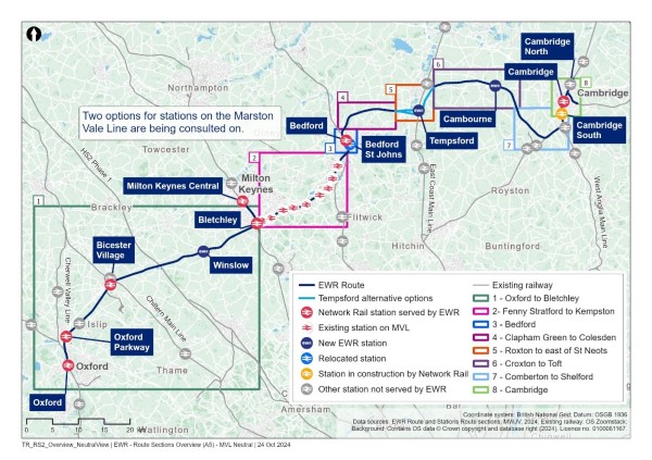
Figure 2 - Oxford to Bletchley study area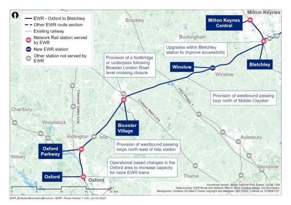
Figure 3 - Fenny Stratford to Kempston study area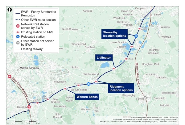
Figure 4 - Bedford study area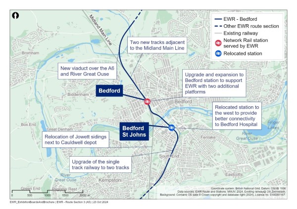
Figure 5 - Clapham Green to Colesden study area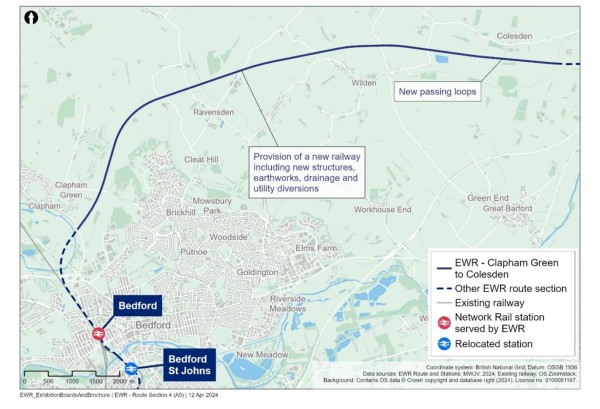
Figure 6 - Roxton to east of St Neots study area
Figure 7 - Croxton to Toft study area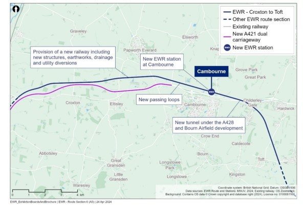
Figure 8 - Comberton to Shelford study area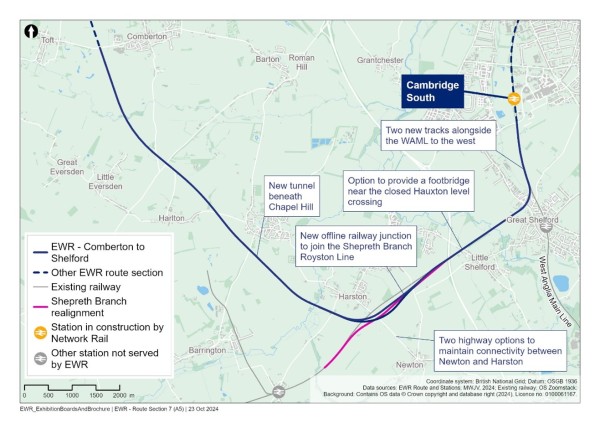
Figure 9 - Cambridge study area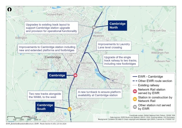
5. Transport policy and guidance
5.1 Chapter overview
This section includes a summary of current and emerging, national, regional, and local planning and transport planning policies and guidance relevant to the assessment of the project.
The project would have multiple traffic and transport impacts in several local authority areas. Therefore, the policy review reflects those local planning authorities and local highway authorities within the study areas detailed in the previous section. In addition to these authorities, areas of the strategic road network (SRN, managed by National Highways) would be impacted as would parts of the rail network.
If during the duration of the study, further transport impacts are identified in areas not covered by the policy review documents in the following sections, the relevant authorities would be engaged with, at the appropriate time. Likewise, this section will be reviewed and updated to capture new and emerging policy and guidance as appropriate in advance of the DCO application.
5.2 National policy
National Networks National Policy Statement, March 2024
The National Networks National Policy Statement (NN NPS) sets out the need for, and government’s policies to deliver, development of Nationally Significant Infrastructure Projects (NSIPs) on the national road and rail networks in England. The Secretary of State will use the NPS as the primary basis for making decisions on development consent applications for NSIPs on the national road and rail networks in England. The NPS is likely to be the primary policy for Secretary of State decision making on projects in the field of national networks for which a direction under section 35 of the Planning Act 2008 has been given.
The NPS identifies the following drivers of need for development of the national networks:
- Maintaining network performance and meeting customer needs.
- Supporting economic growth.
- Ensuring resilience in networks.
- Supporting the government’s environment and net zero priorities.
- Maintaining and enhancing the safety of national networks.
The NPS states the government’s conclusion that at a strategic level there is a compelling need for development of the strategic road and strategic rail networks. The NPS contains general policies against which DCO applications relating to national networks infrastructure are to be decided and sets out how environmental impacts, including impacts on transport networks should be considered.
National Infrastructure Delivery Plan (NIDP) 2016 to 2021, March 2016
The National Infrastructure Delivery Plan (NIDP) sets out the government’s plans for economic infrastructure and plans for the delivery of housing and social infrastructure, which will drive wider economic benefits. The NIDP notes that “economic infrastructure networks are vital to improving quality of life but also integral to the creation of new places to live and work alongside plans for major housing and regeneration schemes and social infrastructure”.
EWR is included with the NIDP Infrastructure Pipeline which would help to support the then government’s vision to “provide world class train services that drive economic growth and exceed passenger expectations”. One of the NIDP priorities for rail is Network Rail enhancement programme which includes EWR.
National Planning Policy Framework (NPPF), December 2023
The National Planning Policy Framework (NPPF) sets out the Government’s planning policies for England and how these should be applied. It provides a framework within which locally prepared plans for housing and other development can be produced.
Section 2 ‘Achieving sustainable development’ of the NPPF states that to achieve sustainable development, the planning system has three objectives:
- An economic objective.
- A social objective.
- An environmental objective
Section 6 ‘Building a strong, competitive economy’ of the NPPF states that it is important to support economic growth and productivity, considering local business needs and wider opportunities for development. Planning policies should seek to address potential barriers to investment such as inadequate infrastructure.
Transport Investment Strategy (TIS), July 2017
The Transport Investment Strategy (TIS) sets out the DfT’s priorities and approach for future transport investment decisions. Through investment, the strategy seeks to:
- Create a more reliable, less congested, and better-connected transport network that works for the users who rely on it.
- Build a stronger, more balanced economy by enhancing productivity and responding to local growth priorities.
- Enhance our global competitiveness by making Britain a more attractive place to trade and invest.
- Support the creation of new housing.
To address challenges with the transport network, the TIS identifies that different types of investment need to be prioritised, including:
- Improving the condition and the performance of the existing network.
- Expanding existing capacity to ease congestion.
- Enhancing connectivity by adding new capability.
- Improving the user experience.
- Adapting the network to safeguard our environment, safety, and health.
The TIS states that national networks enable the country to operate as a single economic entity, connecting major cities and conurbation and linking them to international gateways. Investment in the rail network is centred on how to get the most out of the existing network including increasing capacity or improving service performance, by lengthening trains and platforms, constructing flyovers and underpasses to remove bottlenecks, and adding new track.
Gear change: a bold vision for cycling and walking July 2020 (Active Travel England)
This strategy aims to improve walking and cycling throughout England. “Places will be truly walkable. A travel revolution in our streets, towns and communities will have made cycling a mass form of transit. Cycling and walking will be the natural first choice for many journeys with half of all journeys in towns and cities being cycled or walked by 2030”.
DfT Circular 01/22 Strategic Road Network and the delivery of sustainable development
This policy paper explains how National Highways will engage with the planning system and fulfil its remit to be a delivery partner for sustainable economic growth whilst maintaining, managing, and operating a safe and efficient strategic road network.
National Highways are a key transport stakeholder for the project and will be engaged with as the assessment progresses. More information on engagement is provided in Chapter 8.
5.3 Regional policy
England’s Economic Heartland (EEH) Regional Transport Strategy: Connecting People, Transforming Journeys (2021)
England’s Economic Heartland (EEH) is the sub-national transport body for the region stretching from Swindon across to Cambridgeshire and from Northamptonshire down to Hertfordshire. The transport strategy is ambitious and sets out a policy framework to deliver the following vision:
“To support sustainable growth and improve quality of life and wellbeing through a world-class, decarbonised transport system which harnesses the region’s global expertise in technology and innovation to unlock new opportunities for residents and businesses, in a way that benefits the UK as a whole”.
The strategy sets out how the region would:
- “Focus on decarbonising our transport system by harnessing innovation and supporting solutions which in themselves create green economic opportunities.
- Promote investment in digital infrastructure as a means of improving connectivity.
- Use the delivery of strategic public transport schemes - such as East West Rail, the Cambridgeshire Autonomous Metro and Milton Keynes Mass Rapid Transit - as the catalyst for a shift towards lower carbon modes of travel.
- Champion increased investment in active travel and shared transport to improve local connectivity to ensure that everyone can realise their potential.
- Continue to ensure the needs of the freight and logistics sector are met whilst lowering its environmental impact.”
Policies 9, 10 and 11 reference EWR and the support for the project. Policy 9 states that EEH expects that the Oxford to Bletchley/Milton Keynes section is open by 2025, with links to Bedford and Aylesbury to follow at the earliest possible opportunity thereafter, and Oxford-Cambridge delivered no later than 2030. Policy 10 states that EEH will work to identify the longer-term potential of EWR in supporting economic activity and planned housing growth. Policy 11 states that EWR intersects with existing main lines and establish regionally significant transport hubs.
Cambridgeshire and Peterborough Combined Authority Local Transport and Connectivity Plan (2023)
The Local Transport and Connectivity Plan (LTCP) sets out the current and future transport needs within the combined local authority areas and identifies policies explaining how they will contribute to the delivery of local transport priorities.
This vision for the plan is as follows:
“A transport network which secures a future in which the region and its people can thrive”.
Its mission statement is:
“The transport network must put improved health at its core, it must help create a fairer society, it must respond to climate change targets, it must protect our environment and clean up our air, and it must be the backbone of sustainable economic growth in which everyone can prosper.
And it must bring a region of cities, market towns and very rural areas closer together. It will be achieved by investing in a properly joined-up, net zero carbon transport system, which is high quality, reliable, convenient, affordable, safe, and accessible to everyone. Better, cleaner public transport will reduce private car use, and more cycling and walking will support both healthier lives and a greener region. Comprehensive connectivity, including digital improvements, will support a sustainable future for our region’s nationally important and innovative economy.”
There are six main goals within the plan:
- Productivity: Giving both employers and people the means to achieve more of their potential, making them more efficient and more innovative to create more prosperity.
- Connectivity: People and communities are brought closer together, giving more opportunity for work, education, leisure, and pleasure.
- Climate: Successfully and fairly reducing carbon emissions to net zero by 2050.
- Environment: Protecting and improving our green spaces and improving nature with a well-planned and good quality transport network.
- Health: Improved health and wellbeing enabled through better connectivity, greater access to healthier journeys and lifestyles and delivering stronger, fairer, more resilient communities.
- Safety: To prevent harm by reducing risk and enabling people to use the transport system with confidence.
Within the document the combined authority commits to working with EWR, so their proposals fully integrate with the new EWR infrastructure proposed. The combined authority states that it will champion and support the delivery of EWR and appreciate the benefits that the scheme will bring.
There are several documents that underpin the LTCP and provide visions and strategy for various parts of the network to deliver the goals and objectives of the plan. These include:
- CPCA Bus Strategy.
- Cambridgeshire County Council (Highway Authority) transport strategies (see following sections).
5.4 Local policy
Cambridgeshire transport related strategies
An Active Travel Strategy was published by Cambridgeshire County Council in 2023 and contains “a comprehensive set of policies that will enable quality provision of active travel infrastructure and initiatives in Cambridgeshire to contribute to the County Council’s target to achieve net zero carbon by 2045”. The Local Cycling and Walking Infrastructure Plan (LCWIP) sits under the Active Travel Strategy and identifies “the top priority active travel routes in each district for new or improved infrastructure for walking and/or cycling”.
There are also a set of district transport strategies which “support(s) the overarching vision and objectives of the Cambridgeshire and Peterborough Combined Authority’s draft Cambridgeshire and Peterborough Local Transport and Connectivity Plan (LTCP) and will be adopted as a ‘child document’ of the LTCP”.
Finally, there is a Rights of Way Improvement Plan, first adopted in 2006 and updated in 2016, with the main objective being “to manage, improve and promote a Public Rights of Way (PRoW) network as an integral part of a wider transport system which meets the needs of the whole community for safe sustainable local transport, which improves public health, enhances biodiversity, increases recreational opportunities and contributes to the rural economy”.
Oxfordshire Local Transport and Connectivity Plan (LTCP) (July 2022)
The Oxfordshire LTCP vision prepared by Oxfordshire County Council is set out as follows:
“Our Local Transport and Connectivity Plan vision is for an inclusive and safe net zero Oxfordshire transport system that enables all parts of the county to thrive. It will tackle inequality, be better for health, wellbeing and social inclusivity and have zero road fatalities or life-changing injuries. It will also enhance our natural and historic environment and enable the county to be one of the world’s leading innovation economies. Our plan sets out to achieve this by reducing the need to travel and private car use through making walking, cycling, public and shared transport the natural first choice.”
The key targets include replacing or removing one out every four car trips in Oxfordshire by 2030, delivering a net zero transport network by 2040 and delivering a transport network that contributes to a climate positive future by 2050.
These targets will be achieved by avoiding or reducing the need to travel, shifting to less polluting transport modes, and improving vehicle and fuel efficiency.
The connectivity plan states that Oxfordshire will continue to support EWR, recognising the connections and improvements that the project will enable.
Policy 21 states that the Oxfordshire Rail Corridor Study and Oxfordshire Connect projects will guide their approach to rail and priorities for rail investment.
Buckinghamshire’s Local Transport Plan (LTP4) (December 2016)
The LTP4 prepared by Buckinghamshire Council aims to “make Buckinghamshire a great place to live and work, maintaining and enhancing its special environment, helping its people and businesses thrive and grow to give us one of the strongest and most productive economies in the country.”
- “Provide a well-connected, efficient, and reliable transport network which links to key national and international destinations helping Buckinghamshire’s residents and economy to flourish while capitalising on external investment opportunities.
- To secure good road, public transport, cycle and walking infrastructure and service provision, working in partnership with local businesses, the community and district councils through a range of initiatives and taking advantage of new and emerging technologies to meet the (current and future) needs of our residents as Buckinghamshire grows.
- Allow residents to improve their quality of life and health, by promoting sustainable travel choices and access to opportunities that improve health. Ensure transport systems are accessible by all, safe and allow people to make the most of Buckinghamshire whilst protecting its special environments.
- Allow everybody to access the educational, work, and social opportunities they need to grow. Increase opportunities for residents to support themselves and their communities by enabling local transport solutions.”
Policy 4 states “Maximising our rail network - We will work in partnership with key stakeholders to develop a reliable rail transport network that: provides effective access within the county links us to the rest of the country and is integrated with other modes of transport, including airports. Buckinghamshire will continue to work with EWR, supporting the earliest possible delivery. The scheme will improve service capacity between Aylesbury and Princes Risborough”.
Buckinghamshire Council is currently in the process of developing LTP5 to cover the period to 2040.
Mobility Strategy for Milton Keynes 2018-2036 (LTP4) Mobility for All (March 2018)
The LTP4 for Milton Keynes comprises the Mobility Strategy adopted in 2018 and a suite of supporting strategies which provide further detail and direction to support the delivery of the Mobility Strategy objectives. The Mobility Strategy outlines how Milton Keynes will maintain, improve, and develop its transport network up to 2036. Its associated Action Plan the approach to implementation of the strategy. At the time of writing, an updated suite of supporting plans and position papers is being prepared to guide delivery of the strategy, with the Transport Infrastructure Delivery Plan (TIDP) being one plan (adopted 2019) to provides a framework for the development and delivery of transport infrastructure required for Milton Keynes over the next 15 years.
The Mobility Strategy objectives are as follows:
- Support growth and provide mobility for all.
- Provide an effective network.
- Maximise travel choices.
- Protect transport users and the environment.
The approach to maintaining and improving the current transport system is identified within the delivery plan. This includes “Connectivity to East West Rail” in the short term which involves ensuring all rail stations are linked to development sites and key destinations by sustainable transport options from EWR.
Improving public transport is also identified within the delivery plan and within this expanding capacity for Central, Bletchley, and Wolverton stations is identified as a medium to long term completion. This includes improving first and last mile connectivity such as provision of shelters and real-time passenger information.
One of the supporting strategies to LTP4 is the ‘Road Safety, Walking & Cycling and Smarter Travel Strategy’ published in October 2021.
Milton Keynes Council is currently in the process of developing LTP 5 to cover the period to 2040.
Central Bedfordshire Local Transport Plan 3 (2011)
The LTP prepared by Central Bedfordshire Council provides a long-term framework for transport infrastructure throughout Central Bedfordshire. This includes all forms of transport.
The vision for the LTP is as follows:
“Globally connected, delivering sustainable growth to ensure a green, prosperous and ambitious place for the benefit of all by creating an integrated transport system that is safe, sustainable and accessible.”
There are several LTP objectives that relate to the EWR project along with associated sustainable community strategy priorities.
- Increase the ease of access to employment by sustainable modes - maximising employment opportunities and getting around and caring for a lean and green environment.
- Reduce the impact of commuting trips on local communities - promoting health and reducing health inequalities.
- Enable access to a range of leisure, cultural and tourism facilities for residents and visitors alike by a range of modes of transport.
EWR is identified as a major scheme in the LTP which will be delivered to support growth throughout Central Bedfordshire.
Central Bedfordshire Council is currently in the process of developing LTP4.
Bedford Borough Local Transport Plan 3 2011-2021 (2011)
The LTP for Bedford Borough prepared by Bedford Borough Council sets out the Borough’s transport aims and ambitions and identifies strategies, schemes, and initiatives to deliver these.
The vision for transport in Bedford is as follows:
“To create a transport system in which walking, cycling and public transport are the natural choices of travel for the majority of journeys because they are affordable, healthy, convenient and safe alternatives to the private car.”
The main priorities are:
- To provide a reliable and efficient transport system, to support a strong local economy and facilitate sustainable growth.
- To deliver improvements that encourage a reduction in transport emissions and greenhouse gases, to tackle climate change and develop a low carbon community capable of adapting to the impacts of climate change.
- To promote greater equality of opportunity by providing opportunities for all residents to access key services and facilities.
- To contribute to better safety, security, and health by reducing death, injury or illness from transport and promoting travel modes that are beneficial to health.
- To encourage and support a sustainable transport system that contributes to a healthy natural and urban environment.
- To gain a better understanding of travel behaviour in and out of the Borough, to make informed decisions on how people can be encouraged to make “smarter” sustainable travel choices.
There are several actions identified within the implementation plan, of most relevance to this scheme is “Support the work of the East West Rail Consortium for the reinstatement of rail services between Oxford/Milton Keynes/Bedford/ Cambridge”.
5.5 Local plans
Local plans will be important to take into consideration as the assessment develops as they provide information on how developments may come forward in the future and changes to infrastructure required to support this. This will be key for informing the future baseline for our assessment and understanding likely future demand for transport services.
Relevant Local Plans include:
- Oxford Local Plan 2036 (adopted June 2020).
- South Oxfordshire Local Plan 2035 (adopted December 2020).
- Cherwell Local Plan 2011-2031 (adopted July 2015).
- Emerging Buckinghamshire Local Plan (expected to be published in 2025).
- Vale of Aylesbury Local Plan 2013-2033 - this will supersede the 2004 local plan and is currently at examination in public.
- Milton Keynes Council: Plan MK 2016 - 2031 (adopted March 2019).
- Central Bedfordshire Local Plan 2015 - 2035 (adopted July 2021).
- Bedford Borough Local Plan 2030 (adopted January 2020).
- South Cambridgeshire Local Plan (adopted (September 2018).
- Huntingdonshire’s Local Plan to 2036 (adopted May 2019).
- Cambridge Local Plan 2018 (Adopted October 2018).
Bedford Borough, Central Bedfordshire Council, Cherwell District Council, Milton Keynes, Oxford City Council and South Oxfordshire District Council are all consulting on new Local Plans to 2040. South Oxfordshire and Vale of White Horse District Councils are both in the process of preparing a Joint Local Plan.
5.6 Local cycling and walking infrastructure plans
The following Local Cycling and Walking Infrastructure Plans (LCWIPs) are in place within the study area identifying existing cycling and walking infrastructure and locations for improvements at a local level:
- Oxfordshire (March 2020).
- Buckinghamshire (February 2023).
- Milton Keynes (February 2023).
- Central Bedfordshire (December 2023).
- Bedford (emerging, in progress).
- Cambridgeshire (October 2022).
5.7 Relevant guidance
Relevant guidance has been reviewed that provides advice on when TAs and TSs are required, and what they should contain. This has been used throughout the development of this TUR and will also be relevant to the TA.
These include:
- Transport Analysis Guidance (TAG), Department for Transport, first published 2013, last updated 2024.
- Cycle Infrastructure Design (LTN 1/20), Department for Transport, 2020.
- Guidance on Travel Plans, Transport Assessments and Statements (Ministry of Housing, Communities and Local Government, 2014).
- Transport for New Developments: Transport Assessments and Travel Plans, Oxfordshire County Council, 2014.
- Implementing ‘Decide and Provide’: requirements for Transport Assessments, Oxfordshire County Council,
- Transport Assessment Guidelines, Cambridgeshire County Council, 2019.
- Buckinghamshire Council - Travel plans: Guidance for Developers, 2022.
6. Approach to assessment for TUR
6.1 Overview
This chapter sets out the approach taken specifically within this TUR document to identify preliminary transport impacts associated with the project, based on the design proposals presented at the non-statutory consultation. Information on how the full assessment will be undertaken within the TA once the design is confirmed is set out in the Transport Assessment Scoping Report.
At this stage of non-statutory consultation, an initial qualitative analysis of transport (predominantly highway) impacts has been undertaken to provide information on areas which may be impacted by the project, to help inform early thinking on mitigation. The findings in this report are preliminary and based on the information available at the time of writing, and therefore may change in the full assessment in the TA.
A quantitative impact analysis is not possible at this stage on account of the following factors:
- The design is at an early stage of development. In some locations options are still being considered. Further design development and the choice of option has the potential to influence how the project is constructed and how people will travel, during construction phase, and once EWR is operational.
- A bespoke transport model which includes the entire route from Oxford to Cambridge at both construction and operation is being developed but is not yet completed. The results of the model will be analysed and used to test and validate design decisions. The impact of the project during construction and operation will be considered in detail in the TA which will accompany the DCO application. For the TUR, a Strategic Highway Model (East West Rail Strategic Highway Model or EWRSHM) has been used as an interim tool to assess traffic impacts and forms the basis of information in the TUR.
Accordingly, at this stage of the project, the baseline assessment takes account of publicly available data and information for highways, public transport, and walking and cycling. Because of the timeline for the project, this data would need to be updated for the TA to be prepared and submitted as part of the DCO application.
Non-traffic related transport impacts are based on the design and construction approach available for the non-statutory consultation. Traffic impacts of the project are based on ‘interim’ modelling. The interim traffic model has been used to identify areas of existing concern where these are likely to be impacted by the project at both construction and operation. For the TUR, no mitigation has been developed or tested to address the preliminary impacts presented.
The modelling approach to support the TUR reflects the current preferred options based on the findings of the assessment factor work which is detailed within the Technical Report. Due to the nature of the models, which are strategic, and report impacts at an appropriate level of detail to support the non-statutory consultation, the impacts reported are likely to be mirrored across all the options still being considered. Even though there are differences between options, the differences will have a limited impact on how transport will react to these changes as on a strategic level it will not have a significant impact on journey times to drive a change in travel behaviour.
Conclusions of this impact assessment must be viewed in this context and are presented as a worse case, as mitigation measures will seek to reduce or remove any negative impacts introduced by the project. Information on mitigation will be presented for comment at the statutory consultation.
6.2 Baseline data
The following baseline data has been reviewed to inform the information presented within the study area sections in the TUR:
- Publicly available DfT Traffic Monitoring Surveys.
- Publicly available DfT road traffic collision statistics.
- Publicly available PRoW network routes.
- Publicly available station data from National Rail.
- Publicly available level crossing data from Network Rail.
- Publicly available station entries and exits from the Office of Rail and Road (ORR).
- Publicly available information on bus timetables from operator websites.
- Publicly available mapping.
- Publicly available policy documents from local authorities.
- Analysis of initial outputs from the interim traffic modelling (see following section).
This information together with reviewing local maps and engagement with stakeholders has been used to inform the interim modelling exercise and provided background information on baseline.
6.3 Road traffic collision and safety assessment
To inform our understanding of the baseline, data on road traffic collisions has been obtained from the DfT[1] and assessed to determine locations where incidents have occurred, and to begin to inform early thinking on locations which may have a road safety concern. For the purposes of presenting a baseline, our approach in this TUR has been to collate incidents which have occurred firstly within the study area section boundaries. We have then secondly calculated how many of these occur within approximately a 100m (110 yards) buffer of the project draft Order Limits to concentrate information in close proximity to the project where we expect impacts to be located, given potential impact locations further away are not yet identified.
At this stage, no assessment of incidents further away from this, for example on links which may be forecast to increase in traffic flow, have been reported in the TUR. The TA would undertake a safety review of road traffic collision data for locations where an impact is identified for both construction and/or operation and would use more up to date information directly from local authorities (where available). Please see the TA Scoping Report (appended to this document) for information on the approach to be taken for road traffic collisions and safety for the TA.
6.4 Modelling tools
Strategic Highway Model and impact assessment prepared for non-statutory consultation
A Strategic Highway Model, the EWRSHM, has been used to assess traffic impacts for this TUR and forms the basis of highway information presented. It has been used to understand the operation of the network in future baseline years and identify possible project highway impacts. As noted in the TA Scoping Report (Appendix A), more detailed modelling tools will be developed and applied for the assessment of impacts to be reported in the TA for DCO application.
The EWRSHM model has been developed in a pragmatic and proportionate way that considers Transport Analysis Guidance (TAG) recommendations including validation, calibration, growth, COVID and uncertainty. It has been validated and calibrated to 2019 base year traffic conditions, this model includes the local highway network and model zone system covering the Bedford to Cambridge area and includes a strategic highway network coverage and supporting model zone system detail based on the South-East Regional Transport Model for the rest of the project area of interest.
The model time periods for the Strategic Highway Model (EWRSHM) are as follows:
- AM peak hour : 08:00 to 09:00.
- Inter peak average hours: 10:00 to 16:00.
- PM peak hour: 17:00 to 18:00.
The geographical coverage of the model is shown in Figure 10.
Figure 10 - EWRSHM model geographical coverage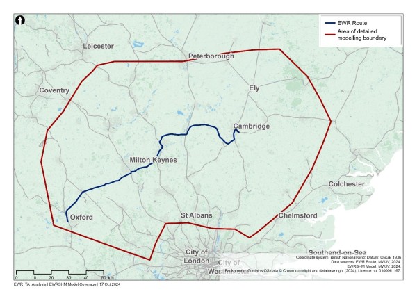
The assessment of traffic related highway impacts included in this TUR would use Volume over Capacity (VoC) outputs from the EWRSHM to review the road network operation. Outputs from the model are in diagrammatic form and therefore no not directly align on top of traditional OS base mapping, but instead form a network layout.
Within strategic transport models such as EWRSHM, the VoC statistic on road links and junctions is used to determine how the network is operating in terms of traffic flows in comparison to the capacity of the roads or junctions.
- A VoC statistic below 0.85 (85%) is generally accepted to indicate that the road link or junction in question is operating below its theoretical capacity and that traffic delay or congestion would not be expected under typical conditions.
- A VoC Statistic between 0.85 (85%) and 0.99 (99%) indicates that traffic flow at a road link or junction is approaching the theoretical capacity of the road or junction in question and some delay and congestion is to be expected.
- A VoC Statistic of 1.00 (100%) and above indicates that traffic flow at a road link or junction exceeds the theoretical capacity of the road or junction in question and that congestion and delay will take place.
For the TUR and TA, to understand locations where there would be capacity concerns, we will be focussing on links and junctions which are equal to or above 0.85 (85%) VoC in any of the scenarios or time periods to be assessed.
Assessment years and periods for modelling
The following table sets out the scenarios and assessment years which were used in the assessment for the TUR and the additional scenarios that would be available for the TA. The programme for the project is still under development, and these are indicative dates for traffic modelling and assessment purposes. The scenarios include assessment of the following single years:
- 2023: baseline.
- 2032: construction.
- 2034: year of opening.
- 2049: future year.
For each of the years, they would firstly be modelled as a single year, referred to as a reference case, with no project traffic or scheme considerations. This provides an understanding of the future operation of the network in each of the scenario years and informs the future baseline understanding, with the 2023 results forming the current baseline understanding.
The project (construction traffic for 2032 and/or operational movements associated with changed journeys and demand for 2034 and 2049) would then be layered on top of the reference cases for each scenario to understand the impact of the project, when compared to the relevant reference cases.
For the TUR, no mitigation has been identified to be tested, therefore the worst case is presented but for the TA, additional assessments would then be undertaken to include mitigation measures within the assessment which will seek to reduce or remove any negative impacts introduced by the project.
At this stage of project development, the construction methodology is still developing. The assessment is based on the average EWR traffic levels in the peak month of construction traffic activity across the network. This provides a consistent and ‘maximum most likely’ basis against which to compare and assess construction impacts across the entire route.
Construction impacts would be modelled for a single year during this construction period and would represent individual or overlapping activities regardless of timing. All over-lapping construction activities are considered in combination. As project construction detail is still being developed, for the TUR, we have undertaken a review of the 2032 network and highlighted links that have the potential to go above the 0.85 (85%) capacity threshold presented above.
It is also recognised that there would be a phased opening of the route, but for the purpose of assessment, a single opening year of 2034 would be the basis of the assessment.
Table 2 provides an overview of the various scenarios which have been used to inform the TUR.
Table 2 - Highway modelling assessment scenarios and years
|
Scenario |
Year |
TUR |
TA |
|
Baseline |
2023 |
yes |
yes |
|
Construction reference case |
2032 |
yes |
yes |
|
Construction + project construction traffic |
2032 |
yes |
yes |
|
Construction + project construction traffic + mitigation |
2032 |
no |
yes |
|
Opening year (operational) reference case |
2034 |
yes |
yes |
|
Opening year + project |
2034 |
yes |
yes |
|
Opening year + project + mitigation |
2034 |
no |
yes |
|
Future year (operational) reference case |
2049 |
yes |
yes |
|
Future year + project |
2049 |
yes |
yes |
|
Future year + project + mitigation |
2049 |
no |
yes |
Strategic Highway Model and impact assessment prepared for DCO
A new bespoke strategic highway model will be completed and used to test and validate design decisions. It will cover the entire EWR route and be used for the TA that will support the DCO application.
Because of the changes to the baseline, modelling assumptions and project design between this stage of non-statutory consultation, the later statutory consultation and submission of the DCO application, it is possible that some of the impacts identified in this TUR would differ from those identified in the TA at a later stage. Similarly, it is possible that reporting of future baseline conditions would change.
This is an expected outcome when using different models with different underlying assumptions. It is the aim of the TUR to provide a high-level assessment of impact at an early stage. It is the impacts and outcomes provided within the TA that the project would ultimately be judged on through the DCO process.
6.5 Project information for modelling
The following sections set out information for construction (2032) and operation (2034 and 2049) that has underpinned the modelling to date.
Construction
At this current stage it is envisaged that construction compounds would be located at points along the EWR route, from which all construction activity would be managed. There are two types of construction compounds.
- Satellite compounds having minimal workforce welfare accommodation and being focused on specific construction activities.
- Main compounds having a wider role of providing site offices, storage of construction material, welfare facilities and, in some locations, the potential for provision of workforce accommodation.
Based on qualitative assessment work to date, of all the compounds currently envisaged there would be a mix of satellite and main compounds.
- For sections from Oxford to Kempston along the existing railway alignment between Oxford and Bicester and Bletchley to Bedford, compounds are generally associated with specific isolated construction activities such as station upgrades and new or upgraded structures and are independent of each other, with construction Heavy Goods Vehicles (HGVs) required to use the public highway network.
- For sections from Clapham to Shelford, compounds are located throughout the new alignment and are associated with all construction activities required to build the new railway. Many of these compounds would be linked to each other by on-site construction routes along the alignment and this would allow some construction HGVs, particularly mass haul movements required to construct new earthworks, to stay off public roads.
- For sections in Bedford and Cambridge, compounds are a mix of isolated compounds in the urban areas and linked compounds on the outskirts where new railway alignment is to be constructed.
Construction traffic routes to support the delivery of these works would be strictly controlled and the route to the nearest point of connection to the strategic road network (motorway and major A roads) would be assessed and defined to reduce the impact to the local area and stakeholders.
At this early stage, information on construction HGV and workforce movements can only be coarsely assessed due to emerging data on construction volumes and timing of construction activities.
As more details of construction traffic activity become available, more detailed assessment of construction traffic impacts would be undertaken using the bespoke strategic highway model currently under development. The National Highways A428 Black Cat to Caxton Gibbet improvement scheme (A428 scheme) has been assumed to be complete before EWR construction of the main infrastructure, embankments and viaducts begins and construction HGV traffic routes have been assumed to use the new road where this is appropriate.
Traffic has been assigned to the network within the EWRSHM. Hourly construction HGV traffic flows to and from each compound have been estimated to be 10% of daily ranges, based on compounds having a 10-hour working day. The construction HGV journeys are expected to occur from 08:00 to 18:00 on weekdays and these HGV journeys would therefore use the highway network during the weekday peak periods.
Highway network changes
In locations where construction of the project would require temporary or permanent changes to the highway network, the expected approximate durations of any works affecting traffic have also been identified. These durations would be refined further as construction methodologies and potential impacts of the project’s works on traffic flow are better understood.
The TUR traffic modelling does not include any highway network changes that would be in place for fewer than three months due to the model assessing a full year scenario. No assessment of these changes has been undertaken at this stage when only coarse information is known on construction.
The means of constructing the project and managing short and long-term impacts on vehicular traffic, NMUs, residents and other directly affected stakeholders would be set out in the CoCP and CTMP as the project is developed. Transport impacts of the project during construction would also be assessed in the TA. These documents would all be submitted as part of the DCO application.
While preliminary assessment of construction impacts from the project has been undertaken, the emerging outcomes are only able to be assessed in broad qualitative terms at this stage. The method of assessment used may also result in reported construction impacts being significantly greater in the early assessment than will be realised. More in-depth analysis of construction impacts would be incorporated into the draft and final TA. These would also reflect the outcomes of further stakeholder consultation.
Utility infrastructure impacts
The construction of the project would require changes to utility infrastructure. Utility changes likely to be required include diverting or adding gas, telecoms electricity and water/sewer infrastructure beneath roads. These changes are expected to result in temporary impacts to the local highway network and to PRoWs, affecting vehicular traffic and NMUs.
Utility infrastructure works on public highways may require temporary traffic management such as short-term temporary road closures, temporary traffic signals for shuttle working of traffic and temporary impacts to bus routes and footways. PRoWs may also require temporary closure where they’re affected by changed or new utility routes. This may result in temporary diversions of NMUs. The need for utility infrastructure changes has not yet been fully defined at this stage but would be identified and their impacts would be assessed in the TA.
At the time of the non-statutory consultation the extent of utility works required to enable the project is not fully known. Accordingly, the impact of these works is not included in TUR traffic modelling and are not assessed in this document.
Cumulative construction impacts
The assessment of construction impacts at this preliminary stage has been undertaken for a single modelled construction scenario. This has required judgement of which construction activities affecting the highway network could occur simultaneously. This means that the current assessment of highway impacts is likely to form an unrealistic worst case. As more detail of construction programme activities and sequences becomes available, assessment of highway impacts is expected to become more refined.
Operation
The operation of the project would change travel behaviour on the transport network and within communities between Oxford and Cambridge. The new services would generate demand for travel by train, journeys that would have otherwise been made by another mode. The new stations and the existing stations to be served by EWR would experience a change in transport demand as new journeys are made.
In the TUR the impact of the operation of the project on the transport network is assessed using the EWRSHM. The modelling approach to support the TUR reflected the preferred options at the time of undertaking the modelling and review work in early 2024, based on the findings of the assessment factor work which is detailed within the Technical Report which has been published as part of the non-statutory consultation.
The future transport demand generated by the project by all modes has been calculated taking account of the different types of highway trips associated with station access and egress. This total EWR demand has then had modal share information applied to calculate the number of trips which would arrive as highway trips i.e. car driver, car passenger, taxi or bus. These EWR trips were then overlaid onto the existing highway traffic flows in the vicinity of the stations, to provide a worst case scenario for trips accessing the new EWR services. A more detailed approach to calculate the abstraction of these trips from existing highway and public transport demand will be developed and used at later stages of the projects development.
More detail on the approach to assessment to be taken for the TA can be seen in the TA Scoping Report (Appendix A).
[1] https://www.gov.uk/government/collections/road-accidents-and-safety-statistics
7. Consultation and Stakeholder Engagement
7.1 Overview
An intrinsic element to the TUR and TA is stakeholder engagement with local, regional, and national bodies, as well as feedback from the public through the non-statutory and statutory consultation periods. This chapter will outline the stakeholder organisations engaged with to date and discussion themes.
Stakeholder engagement will be ongoing through to the DCO submission.
7.2 Stakeholder organisations
Table 3 sets out our key national and local authority stakeholders for the project specifically for transport. These will be engaged with as part of the development of the TA.
Table 3 - Highway and Local Planning along the Route of EWR
|
National Authorities (transport) |
Local Planning Authorities |
|
Network Rail (for the rail network) |
Oxford City Council (Oxford CC) |
|
National Highways (for the SRN) |
South Oxfordshire District Council (SODC) |
|
Active Travel England |
Cherwell District Council (CDC) |
|
Regional Authorities |
|
|
England’s Economic Heartland |
|
|
Cambridgeshire and Peterborough Combined Authority |
|
|
Local Highway Authorities |
Milton Keynes Council |
|
Oxfordshire County Council (OCC) |
Buckinghamshire Council |
|
Buckinghamshire Council (BC) |
Central Bedfordshire Council |
|
Milton Keynes Council (MKC) |
Bedford Borough Council |
|
Central Bedfordshire Council (CBC) |
Huntingdonshire District Council (HDC) |
|
Bedford Borough Council (BBC) |
South Cambridgeshire District Council (SCDC) |
|
Cambridgeshire County Council (Cambs CC) |
Cambridge City Council (CCC) |
Additional highway and local authority stakeholders will be identified and engaged with as necessary, to ensure coverage of and representation for the full area of impact, if this changes from that currently presented in this TUR.
7.3 Transport Assessment Scoping Report
Engagement to date has focussed on the TA Scoping Report (Appendix A) and our approach to undertaking the TA, and this TUR as its predecessor. There will be continuous engagement with stakeholders to inform them on the development of the TA.
Feedback received from stakeholders to date has been used to shape the TA Scoping Report (Appendix A) and some elements of this TUR, with the following key points accommodated:
- Amendments to policy to capture current documents, and discussions to understand future, emerging documents of relevance.
- Information on existing and future baseline has been provided in terms of committed or pipeline transport schemes to be aware of or anticipated changes to networks.
- The approach to assessment has been refined to take into consideration feedback.
- The extents of the study area to form the basis of the assessment (i.e., specific locations within the route sections) have deliberately been left open at this stage to accommodate all locations that could experience some form of impact once the design is finalised and assessment completed, with opportunity for the discussion around mitigation with stakeholders.
7.4 Looking forwards
As the project progresses, we will continue to have ongoing dialogue with relevant stakeholders on a regular basis to ensure their comments are fed into the assessment. This will be reported on through the TA.
8. Oxford to Bletchley
8.1 Baseline area
The area is defined by the City of Oxford and its train station to the west and Bletchley and its station forming part of South Milton Keynes to the east. Between Oxford and Bletchley, EWR would use the existing section of operational railway between Oxford and Bicester. It would then continue onto the reinstated section of railway between Bicester and Bletchley currently being built as part of EWR CS1 and introduce a passenger service between Oxford and Milton Keynes in 2025. The EWR route in this area would pass through the Local Authority areas of Oxford City Council, Oxfordshire County Council and Cherwell District Council within Oxfordshire to the west, passing through Aylesbury Vale in Buckinghamshire Council within the central section with Bletchley located within the Milton Keynes Council authority area.
Current baseline
Rail network
Historically, the Varsity Line (or Oxford to Cambridge railway line) provided a direct rail connection between Oxford and Cambridge via Bletchley and Bedford. However, between Oxford and Bletchley, only Oxford to Bicester Village is in use at present. A two-track connection is provided between Oxford station and the Chiltern Mainline which passes through High Wycombe and Princes Risborough towards London Marylebone.
On this western section there are intermediate stations at Oxford Parkway, Islip (where for overall network timetable expediency, during certain timetable cycles a limited number of CS1 services may call) and Bicester Village. The Chiltern Mainline continues north-west of the EWR alignment and includes a station at Bicester North. Oxford station is also on the Thames Valley branch line of the Western Route, providing a connection into London Paddington via the Great Western Main Line.
At the eastern end of this section, Bletchley station provides a stop on the West Coast Main Line into London Euston. It is served by trains operated by West Midlands Trains. Milton Keynes Central station is one stop to the north of Bletchley on the West Coast Main Line and is expected to be served by a branch of EWR once operational. It is served by trains operated by Avanti West Coast and LNR.
The existing rail network in the section study area can be seen in Figure 11.
Figure 11 - Existing rail network in the Oxford to Bletchley study area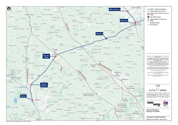
Table 4 summarises the existing stations along the EWR route and their facilities and destinations.
Table 4 - Oxford to Bletchley existing railway stations
|
Station |
EWR service |
Facilities |
Destinations |
|
Oxford |
Yes |
· Ticket office · Waiting rooms · Toilets · Car park (530 spaces) · Bicycle storage |
· London Marylebone · London Paddington · Banbury · Reading · Hereford · Didcot Parkway · Worcester Shrub Hill · Bournemouth · Manchester Piccadilly · Newcastle |
|
Oxford Parkway |
Yes |
· Ticket office · Waiting room · Toilets · Car park (830 spaces) · Bicycle storage |
· Oxford · London Marylebone |
|
Islip |
No* |
· Car park (23 spaces) · Bicycle storage |
· Oxford · London Marylebone |
|
Bicester Village |
Yes |
· Ticket office · Waiting rooms · Toilets · Car park (223 spaces) · Bicycle storage |
· Oxford · London Marylebone |
|
Bletchley |
Yes |
· Ticket office · Toilets · Car park (521 spaces) · Bicycle storage |
· Birmingham New Street · London Euston · Milton Keynes Central · Bedford |
* For overall network timetable expediency, during certain timetable cycles a limited number of CS1 services may call at Islip.
Source: National Rail
Construction of the first phase of EWR is underway along the remainder of the old Varsity Line north-east of Bicester. There is an existing single-track chord (referred to as the Claydon L.N.E Junction) providing a connection from the old Varsity Line south-west of Winslow to the London-Aylesbury Line into London Marylebone. This chord is used by freight trains but not by passenger services.
Table 5 summarises the existing demand at stations along the route in this area through station entries and exits. Oxford station has around 6,582,000 entries and exits and is therefore the busiest, followed by Bicester Village, Bletchley, Oxford Parkway and finally Islip with around 26,000 entries and exists.
Table 5 - Oxford to Bletchley station entries and exits
|
Station |
Entries and exits (April 2022 to March 2023) |
|
Oxford |
6,581,606 |
|
Oxford Parkway |
584,930 |
|
Islip (non EWR) |
26,038 |
|
Bicester Village |
1,610,596 |
|
Bletchley |
734,210 |
Source: ORR - Table 1410.
There is one level crossing within this study area at London Road in Bicester, near Bicester Village station. This is a manually controlled barrier crossing with CCTV. The nearest alternative pedestrian crossing opportunity is via a bridge approximately 500m (550 yards) to the north-east of the level crossing, which connects a pedestrian footpath near Goldfinch Play Park to the south of the track, with Launton Road to the north of the track. Either side of the bridge structure is accessible via steps or a ramp. Alternative road crossings are via the A41 to the south, or via the A4421 ring road north then onto Launton Road.
Bicester Village station has a bridge crossing which gives access to platforms on either side of the track, however the crossing is only accessible to rail passengers with a valid ticket.
Highway network
Outside of Oxford, Bicester and Bletchley urban areas, the area is mostly rural and connected by single carriageway roads and B roads. The M40 motorway runs north-south between London and Birmingham, crossing the alignment of EWR to the south of Junction 9 and the village of Wendlebury.
Other main roads in the area include the A34 and the A41. Together, they provide a connection from Oxford to Aylesbury via Bicester (the A41 crosses the alignment of EWR via a bridge just to the south-west of Bicester Village station) and the A421, connecting Bletchley with the M40 Junction 10 via the A43.
The baseline highway network can be seen in Figure 12.
Figure 12 - Baseline highway network for the Oxford to Bletchley study area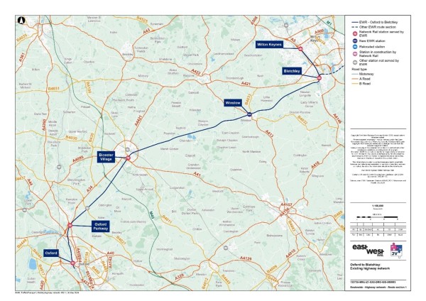
Traffic flows on motorways and major A roads in the study area (recorded as Annual Average Daily Traffic (AADT) by the DfT) are summarised in Table 5. This indicates that the M40 and the A34 are the busiest routes - both carried around 70,000 vehicles per day (both directions combined) in 2023.
Table 6 - Annual Average Daily Traffic
|
Road name (location) |
Daily two-way traffic flow (2023) - all vehicles |
|
M40 (north of Merton) |
69,130 |
|
A34 (north of Islip) |
70,978 |
|
A41 (north of Wendlebury) |
33,773 (estimated) |
|
A421 (north of Little Horwood) |
20,334 (estimated) |
|
A40 (north-east of Oxford) |
40,304 (estimated) |
Source: DfT - Map Road traffic statistics - Road traffic statistics (dft.gov.uk).
There are several highway bridges located throughout this study area. Around Oxford these include the railway bridge over Botley Road, Walton Well Road bridge over the railway line. Adjacent to Oxford Parkway station there is Water Eaton Bridge which goes over the railway line and the A34. In Islip both Bletchingdon Road and Church Close have bridges over the railway line. Around Bicester, there are three bridges that go over the railway line, the M40, Langford Lane and the A41. There are also several additional access bridges serving properties or farmland along the route.
A review of baseline traffic flows in the area using model data has revealed that there are several roads which are currently operating at close to, or over capacity in the AM or PM. These are shown in Figure 13.
Figure 13 - 2023 Baseline routes operating at or over capacity within the Oxford to Bletchley study area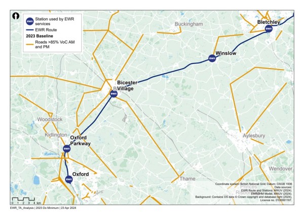
Road traffic collisions
To inform our understanding for the baseline, we have calculated the number of road traffic collisions that have occurred within the section study area, as well as the number which occur within an area which extends approximately 100m (110 yards) from the draft Order Limits of EWR within the Oxford to Bletchley area. This information covers road traffic collisions for the five-year period between 2018 and 2022.
Within this area for Oxford to Bletchley, there were 72 fatal, 736 serious and 3,305 slight road traffic collisions recorded . Within 100m (110 yards) from the draft Order Limits for this section, there were no fatal, six serious and 43 slight road traffic collisions recorded .
Non-motorised users (NMU) network
Around Oxford station, there is a painted cycle lane on Botley Road/Park End Street but this is narrow and provides no segregation for cyclists. This provision continues (with some gaps) towards the city centre to the east. There is a shared pathway located along Becket Street south of the station. To the north, there are several PRoW located to the north of the railway station which are outlined in Figure 14. Pedestrian access to the station is from Botley Road/Park End Street. There is a wide uncontrolled pedestrian crossing of the access road with dropped kerbs close to Park End Street. There is a ramped grade separated crossing from the main car park to the station over Botley Road. An alternative signed route for pedestrians and cyclists is provided to the north of the station. This connects to Stable Close to the north.
At Oxford Parkway station, National Cycle Network Route 51 passes the station along the A4165 Oxford Road. The Sustrans website notes this as a traffic-free route though in reality it constitutes a narrow-shared footway/cycleway on the west side of a busy road with no direct crossing into the station. As such, the cycle access to the station is relatively poor despite being adjacent to a national cycle network route. The route continues to Oxford city centre to the south (taking a relatively indirect route with limited facilities). To the north the route continues to Kidlington and beyond to Bicester. Pedestrian access to the station is from the A4165 Oxford Road where there is a direct pedestrian route to the main station building from the bus stops on this road. A controlled pedestrian crossing is located here. There are limited pedestrian destinations within a reasonable walking distance of the station.
At Bicester Village station, there are no dedicated cycling routes connecting into the station or in the immediate vicinity of the station. However, there are a number of nearby routes that can be used by rail passengers to access the station from the wider area. Most notably, National Cycle Network Route 51, which passes approximately 500m (550 yards) to the west of the station. There is a shared path alongside part of Pingle Drive to the north-west of the station and from the east there is a shared path connecting Gavray Drive and B4100 London Road. Footways are generally provided along roads in Bicester, along with pedestrian crossing facilities on pedestrian desire lines as is typical of an urban environment. The main pedestrian access to the station is from the B4100 London Road to the north, which is approximately 250m (275 yards) from the station entrance. There is a footway and a zebra crossing on Station Approach which connects the B4100 London Road with the station forecourt. Pedestrians can also access the station from the east via the short stay car park. There is also a pedestrian access from Bicester Village Shopping Outlet at the southern end of Station Approach.
Milton Keynes has over 320km (200 miles) of shared-use paths, known as Redways. There is a ‘Redway’ cycle route from Bletchley Park to Bletchley bus station/town centre via the railway station. The route takes the form of a shared footway/cycleway. There are signal-controlled crossings at the two road crossings on this route. Pedestrian access to the station is from Sherwood Drive via the main station access.
Public Rights of Way (PRoW)
Figure 14 presents the existing PRoW network within the section study area. There are several footpaths and bridleways that provide connections with stations within this section.
There are 187 PRoWs within approximately 250m (273 yards) of the EWR route within which 34 cross the railway line itself. The PRoW that cross the EWR line are listed in Table 7.
Figure 14 - Oxford to Bletchley PRoW 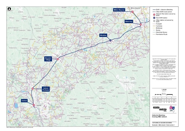
Table 7 - PRoW crossing the EWR railway line
|
PRoW number |
PRoW type |
|
320/4/20 |
Footpath |
|
320/116/30 |
Footpath |
|
320/10/10 |
Footpath |
|
320/12/20 |
Bridleway |
|
320/9/20 |
Footpath |
|
229/10/30 |
Footpath |
|
229/5/40 |
Bridleway |
|
260/19/10 |
Bridleway |
|
157/4/30 |
Bridleway |
|
318/5/60 |
Footpath |
|
398/3/20 |
Footpath |
|
129/3/40 |
Footpath |
|
129/37/20 |
Footpath |
|
272/11/20 |
Footpath |
|
272/12/10 |
Footpath |
|
MGI/5/1 |
Footpath |
|
POD/2/2 |
Footpath |
|
CHA/3/1 |
Footpath |
|
CHA/4/1 |
Footpath |
|
CHA/1/2 |
Bridleway |
|
TWY/2/4 |
Footpath |
|
TWY/4/1 |
Footpath |
|
SCL/8/1 |
Footpath |
|
SCL/9/2 |
Footpath |
|
SCL/1/5 |
Footpath |
|
MCL/4/4 |
Footpath |
|
MCL/3/4 |
Footpath |
|
ADD/12/2 |
Footpath |
|
ADD/11/2 |
Footpath |
|
WIS/6/1 |
Footpath |
|
SWA/17/1 |
Footpath |
|
SWA/1/3 |
Footpath |
|
LHO/20/2 |
Footpath |
|
NLO/19/1 |
Footpath |
|
320/4/20 |
Footpath |
Source: OS Data.
Bus network
Table 8 outlines the bus services that serve EWR stations, or where their route passes a level crossing on the EWR alignment. These include:
- At Oxford station, there are six bus stops (R1-6) outside the station entrance.
- Bus stops along the A4165 Oxford Road and Oxford Parkway Park and Ride serve Oxford Parkway station.
- At Bicester Village station entrance there are two bus stops and along the B4100 London Road there are stops for northbound and southbound services immediately south of the short-stay car park.
- A local bus service operates to Bletchley station with bus stops on either side of Sherwood Drive immediately to the south of the station access.
- The 18, 29, 108 and H5 services all currently cross the railway at Bicester London Road level crossing.
There are also several bus services that serve Winslow along the A413 Buckingham Road including 50, 548, 60, 60A and 67.
The baseline public transport will be reviewed in detail around new railway stations when more information is available on their location. Bus services that may be affected by level crossing closures will also be assessed when more detail is available.
Table 8 - Oxford to Bletchley bus services
|
Service number |
Route |
Operator |
Frequency (per hour) |
EWR Station |
|
1 |
Oxford station to Blackbird Leys |
Oxford Bus Company |
6 |
Oxford |
|
5 |
Oxford station to Blackbird Leys |
Oxford Bus Company |
6 |
Oxford |
|
400 |
Oxford station to Wheatley Campus |
Oxford Park and Ride |
6 |
Oxford |
|
3X |
Oxford station to Oxford Science Park |
Oxford Bus Company |
1 (peak times only) |
Oxford |
|
43 |
Oxford station to Wantage |
Oxford Bus Company |
6:20 only, once service per day |
Oxford |
|
X1 City |
Oxford station to Wantage |
Oxford Bus Company |
2 |
Oxford |
|
14 |
Oxford station to JR Hospital and Risinghurst |
Stagecoach |
2 |
Oxford |
|
X4 |
Oxford station to Banbury Town Centre |
Stagecoach |
6 (peak times only) |
Oxford |
|
S3 |
Oxford station to Chipping Norton |
Stagecoach |
2 |
Oxford |
|
S7 |
Oxford station to Witney |
Stagecoach |
2 |
Oxford |
|
X7 |
Oxford station to Aylesbury |
Arriva |
2 |
Oxford |
|
X8 |
Oxford station to Thame |
Arriva |
2 |
Oxford |
|
City Sightseeing |
Oxford |
City Sightseeing |
2 |
Oxford |
|
700 |
Kidlington - Thornhill Park and Ride via Oxford’s Hospitals |
Oxford Bus Company |
2 |
Oxford Parkway |
|
2/2A |
Oxford City Centre to Kidlington |
Stagecoach |
8 |
Oxford Parkway |
|
24 |
Bicester to Weston on the Green to Kirtlington to Oxford |
Greyline Coaches |
Every 2 hours |
Oxford Parkway |
|
25 |
Bicester to Lower Heyford |
Red Rose Travel |
1 |
Bicester Village |
|
500 |
Bicester Village station to Banbury |
Stagecoach |
1 |
Bicester Village |
|
18 |
Bicester to Buckingham |
Langston and Tasker |
Every 2 hours |
Bicester Village |
|
29 |
Bicester to Upper Arncott |
Stagecoach |
1 |
Bicester Village |
|
108 |
Bicester to Oxford City Centre |
Oxford Bus Company |
Twice a day (11:23 and 14:33) |
Bicester Village |
|
H5 |
Bicester to JR Hospital |
Stagecoach |
1 |
Bicester Village |
|
BV1 |
Bicester North station - Bicester Village station - Bicester Village - Bicester North station |
Oxford Bus Company |
4 |
Bicester Village |
|
4 |
Bletchley to Wolverton via Milton Keynes |
Arriva |
4 |
Bletchley |
A new station is being developed as part of the CS1 works at Winslow, adjacent to the A413 Buckingham Road. There are several bus services that serve Winslow along the A413 Buckingham Road including 50, 548, 60, 60A and 67. The baseline public transport around new railway stations would be reviewed in detail when more information is available on their specific location.
Bus services that may be affected by level crossing closures would also be assessed when more detail is available.
Interchange at stations
Oxford
The connectivity of the station with other modes of transport is shown in Figure 15.
Figure 15 - Oxford station facilities (transport)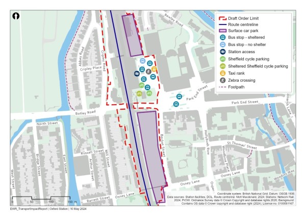
The station is located to the west of Oxford city centre, land use in the immediate vicinity of the station is a mix of commercial, education and residential uses. Pick up and drop off facilities are provided immediately outside the station within the bus interchange area, with long stay parking (approximately 530 spaces) located to the south of the station off Becket Street (on the opposite side of Botley Road).
Cycle facilities are provided with capacity for over 1,000 bicycles with Sheffield stand (steel hoops) cycle parking.
Opportunities for on-street parking surrounding the station are extremely limited. There are controlled parking zones (CPZs) surrounding the station. Residents, their visitors, and local businesses can park in designated bays when displaying a relevant parking permit for that zone. Some spaces are also available for short-term parkers, and Blue Badge holders can park without restriction.
Oxford Parkway
The connectivity of the station with other modes of transport is shown in Figure 16.
Figure 16 - Oxford Parkway station facilities (transport)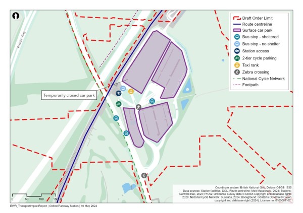
The station is located to the north of Oxford City Centre in a rural area. Oxford Parkway Park and Ride (bus) is located immediately to the south-east of the station. Pick up and drop off facilities are provided immediately outside the station. The station car park has capacity for around 830 cars. Immediately adjacent to the station, Oxford Parkway Park and Ride has approximately 760 spaces.
Opportunities for on-street parking surrounding the station are extremely limited due to the rural location and a lack of nearby residential streets.
Cycle parking facilities are provided at the station with stands for 150 cycles provided within the station forecourt and the National Cycle Network 51 on Oxford Road provides a connection from Oxford to the station. A further 40 spaces are provided within the Park and Ride site.
Bicester Village
The connectivity of the station with other modes of transport is shown in Figure 17.
Figure 17 - Bicester Village station facilities (transport)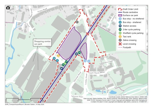
The station is located to the south of the Bicester urban area. Land use in the immediate vicinity of the site is mixed with the Bicester Village Shopping Outlet located to the immediate west. Pick up and drop off areas are provided within the main station car park; the car park has capacity for 223 cars.
8Opportunities for on-street parking surrounding the station are limited. There is a resident’s parking scheme which requires permits to be able to park on the nearby Priory Road.
Cycle parking is provided at the station with stands for 182 cycles provided at the front of the station.
Bletchley
The connectivity of the station with other modes of transport is shown in Figure 18.
Figure 18 - Bletchley station facilities (transport)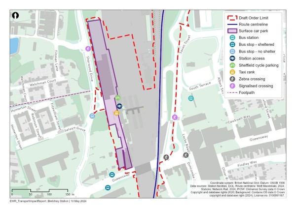
The station is located to the west of Bletchley town centre. Land use in the immediate area is predominantly retail focused to the east (town centre and Brunel shopping centre) and educational to the west (Milton Keynes College). For drop off and pick up, within the main station car park there is a short-stay parking area (maximum 20 minutes), there is also a small area on the access to the station where approximately eight vehicles can drop off passengers in a lay-by. The car park has capacity for approximately 520 cars.
Opportunities for on-street parking surrounding the station are limited.
Cycle parking facilities are provided at the station with stands for 58 cycles provided at the front of the station.
8.2 Future baseline
Future development and transport schemes
Changes to the transport networks would affect how they operate in the future. Additionally, changes to surrounding land use would change demand for use of these networks, meaning the future baseline situation could be dramatically different to the current 2023 baseline scenario, before the project is implemented. For all locations, this could include:
- Planning applications submitted and approved for new developments or Local Plan allocations coming forward.
- Upgrades and improvements to transport infrastructure (highway, active travel, and public transport networks).
Specific to the Oxford to Bletchley section, we have been made aware of the following schemes:
- Safer Roads Oxford - scheme to improve road safety on Banbury Road in north Oxford and Iffley Road in east Oxford.
- North Oxford Corridor project - several road improvement projects along the A44, A4260 Frieze Way and the A4165 Oxford Road/Bicester Road, expected to all be fully completed in 2024 (with some elements already operational).
- Changes to accessibility in Oxford city centre to include zero emission zones and traffic filtering initiatives.
- New cycle scheme proposals at Bicester.
- Adjustments to the layout of Saxon Street and the area around Bletchley.
- Proposals for Oxford United’s new stadium around Oxford Parkway.
- To the east of Bicester Village, there is an allocation for 300 homes at Gavray Drive.
This list is not exhaustive and other schemes and developments would be considered as appropriate as they come forward and as assessment work continues.
Changes in traffic flow
Figure 19 to Figure 21 show the roads which are expected to operate at close to, or over capacity without the project in the years 2032, 2034 and 2049 based on model data.
Figure 19 - 2032 Volume over Capacity >=85% (without the project scenario)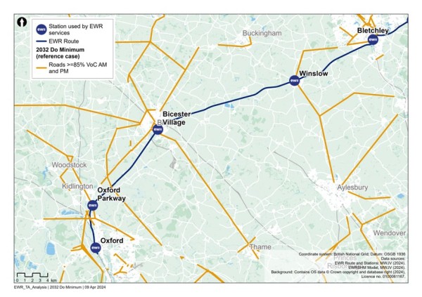
Figure 20 - 2034 Volume over Capacity >=85% (without the project scenario)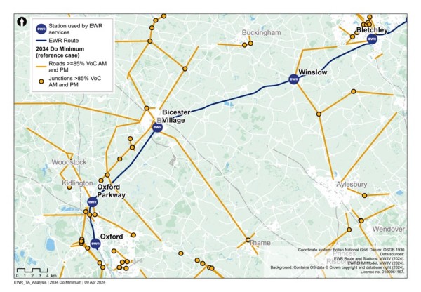
Figure 21 - 2049 Volume over Capacity >=85% (without the project scenario)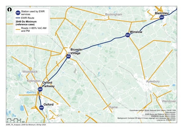
Figure 19 to Figure 21 show that between 2032 and 2049, there are a few additional roads that would operate at close to or over capacity including, the B4017 west of Oxford, a section of the A34 north of Oxford Parkway, the A421 north of Winslow and the A422 west of Buckingham.
8.3 Project proposals
The project between Oxford and Bletchley would use the existing railway. This is currently in use between Oxford and Bicester, with the remainder from Bicester to Bletchley currently under construction as part of East West Rail Connection Stage 1, which will introduce a passenger service between Oxford and Milton Keynes in late 2025. To accommodate the full East West Rail passenger service and freight services, alongside existing services, further works are required along this 48km (30 mile) section of railway.
The proposed works are summarised as follows:
- Track upgrades at Oxford and construction of a facility for traincrew.
- Potential need for upgrades at Oxford station, Oxford Parkway, Bicester Village, Winslow and Bletchley stations to accommodate increased East West Rail passenger numbers. The changes would depend on the results of passenger demand forecasting and pedestrian modelling. This is true for Winslow and Bletchley, which will also consider the type of train selected for use on the new service.
- Closure of the level crossing at Bicester London Road and the construction of an accessible replacement crossing for pedestrians, cyclists and other users of the crossing, either via a footbridge or an underpass.
- Widening of the rail corridor to the east of Islip and at Middle Claydon to create passing loops resulting in the demolition and reprovision of existing footbridges at both locations to maintain PRoW.
- Utility and traction power works to accommodate OLE across the route, with the largest two diversions to electrical infrastructure at Oxford Parkway station and Verney Junction.
Under the full East West Rail service this section would accommodate four passenger trains per hour and one freight train per hour in each direction. These services would be in addition to the existing two trains per hour in each direction on Chiltern services between Oxford and Bicester (continuing to London Marylebone).
Construction compounds and movements
Construction compounds in the Oxford to Bletchley section would generally be located at existing stations, or nearby, and would allow key station upgrade works along this section.
The Oxford to Bletchley works would be less extensive than those proposed further east and as such can be delivered more quickly.
Construction traffic routes to support the delivery of these works would be strictly controlled and the route to the nearest point of connection to the strategic road network (motorway and major A roads) would be assessed and defined to reduce the impact to the local area and stakeholders.
Most construction HGV movements in this section would use the A41/A43 London Road to access the M40 at Junction 9 or Junction 10, while some construction traffic in and around Oxford would access the A34 and a small number of compounds in Bletchley would access the A5.
As construction compounds are, in some cases, located at stations, there may be impacts on station car parking and access for passengers. These impacts would be controlled by provisions within the CTMP and CoCP and coordinated with train operating companies where access to train services is expected to be impacted.
Some construction activities may require temporary suspension of rail services. Alternative transport would be provided where possible, in consultation with train operating companies.
8.4 Potential impacts
Changes in traffic flow
A comparison has been undertaken between the 2032, 2034 and 2049 reference cases (no project) and the corresponding with project scenarios for those years, to determine what links become over capacity when project traffic is added to the network.
Figure 22 shows that road links just to the south of Oxford Parkway station become at or over capacity in 2032 (AM, PM or both time periods) because of construction traffic related to the project.
Figure 22 - Comparison of 2032 reference case (no project) vs 2032 with project: additional roads with a Volume over Capacity >=85%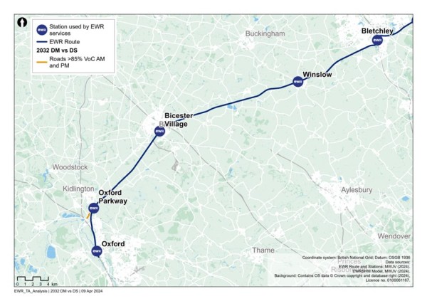
Figure 23 shows the additional roads with a Volume over Capacity of greater than or equal to 85% in 2034 as a result of the project. These include:
- A section of the A34 north of Oxford Parkway station.
- The B4011 northbound between Thame Road which connects the A41 and the A418.
- The B4100 London Road near Bicester Village station.
- Oxford Road/Kings End/Queens Ave west of Bicester Village station.
Figure 23 - Comparison of 2034 reference case (no project) vs 2034 with project: additional roads with a Volume over Capacity >=85%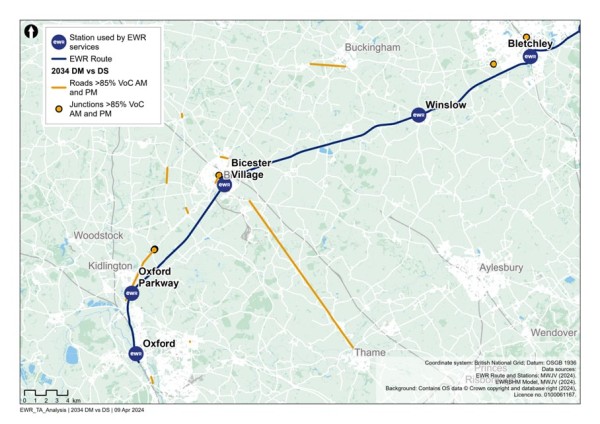
Figure 24 shows the additional roads with a Volume over Capacity of greater than or equal to 85% in 2049 because of the project. These include:
- A section of the A34 north of Oxford Parkway station.
- The M40 between Junctions 9 and 10.
- The A40 East of the M40 at Milton Common.
- The B4100 London Road near Bicester Village station.
- Oxford Road/Kings End/Queens Ave west of Bicester Village station.
Figure 24 - Comparison of 2049 reference case (no project) vs 2049 with project: additional roads with a Volume over Capacity >=85%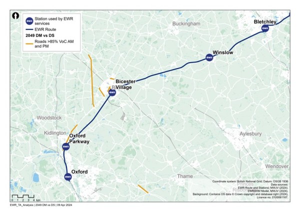
In addition to links which become over capacity in the ‘with project’ scenarios, there would be links that are already operating over capacity in the ‘no project’ scenarios, which are assessed to be pushed further over capacity in the ‘with project’ scenarios. These are not shown in the figures but would form part of further assessment in the TA and subsequent discussions with stakeholders regarding mitigation.
Based on the current design maturity, the following potential impacts in Table 9 could be realised within this study area section.
Table 9 - Oxford to Bletchley potential impacts (transport)
|
Mode/Who |
Phase |
Change |
Potential impact prior to mitigation |
|
All station users |
Construction |
Some construction compounds are proposed to be located at railway stations. |
There may be temporary impacts on station car parking and/or station access for passengers. These impacts would be controlled by provisions within the CTMP and CoCP and coordinated with train operating companies where access to train services is expected to be impacted. |
|
Highway |
Construction |
Construction of the project may require temporary changes to the highway network in some locations. These changes may include the following temporary measures: |
These temporary measures may result in journey delay, congestion, and an increase in traffic on alternative routes. Changes in traffic flow or composition may lead to safety concerns. The CoCP and CTMP would include provisions to reduce the impacts of these works on road users. |
|
Highway |
Construction |
Construction traffic movements on the network. |
Temporary traffic delay and/or congestion on the highway network, in particular routes which accommodate construction traffic. The CTMP and CoCP would include provisions to reduce the impacts of these works on road users. Interim modelling outputs provide initial information on potential locations of impact. |
|
NMUs |
Construction |
Temporary construction works, including traffic management or changes to utility infrastructure required for the project, may affect NMU access and movement. |
In some places, existing level crossings, user worked crossings and footbridges or underpasses crossing the railway may be closed temporarily to allow construction to be safely carried out and this may result in diversions. Temporary traffic management may result in diversion routes or temporary closure of crossing points or footways. |
|
NMUs |
Construction |
Temporary traffic management may be required where the project affects the highway network. |
This may lead to delay on the highway network to pass through temporary traffic management measures, or use of diversion routes. The extents of these potential impacts have not yet been determined. The CTMP and CoCP would include provisions to reduce the impacts of these works on road users. |
|
Rail users |
Construction |
Some construction activities may require temporary suspension of rail services. |
Alternative transport would be provided where possible, in consultation with train operating companies and other affected stakeholders. |
|
NMUs |
Operation |
Existing PRoW routes which cross the proposed route alignment would require new over or underbridge crossing facilities or closure and associated diversions. |
This could lead to an increase in journey distance and journey time for NMUs. The suitability of diversion or alternative routes for all NMUs would be assessed once the design is confirmed to ensure the proposed diversion routes are suitable, with mitigation proposed where required to enhance routes. |
|
Highway |
Operation |
Provision of new rail services would provide travel choice for longer distance trips supporting mode shift from car to rail. Additionally new or enhanced stations providing local access to rail services may also alter local trip patterns. |
Changes to highway demand due to mode shift from car to rail, or a change in local trip patterns with the opportunity to travel to (new) local stations to access enhanced or new rail services. This could result in some localised delay and congestion or see a reduction in traffic in some locations. Options for mitigation to provide additional capacity at locations will be reviewed and discussed with key stakeholders. |
|
Highway |
Operation |
Permanent changes to the highway network at Oxford Parkway (turning) and Bicester London Road level crossing. |
Changes to the highway network may lead to delay and longer journeys (e.g., diversion route for Bicester London Road level crossing). |
|
NMUs |
Operation |
The access junction to Oxford Parkway is included in some wider active travel proposals which look to add a segregated cycle lane along Oxford Road. The impact of increases in traffic associated with the project would need to be reviewed. |
The impact of increased traffic associated with the project would need to be reviewed at this location to check there are no road safety concerns, and that the operation of the adjacent junctions are acceptable. |
|
NMUs |
Operation |
Closure of Bicester London Road level crossing. |
Changes to journey distance and time for NMUs to utilise alternative routes in the vicinity of the current crossing. Proposals for alternative solutions are being developed and will be reviewed and assessed within the TA. Diversion route suitability and mitigation will be reviewed. |
|
Highway, including Public Transport |
Operation |
Closure of Bicester London Road level crossing. |
Additional journey distance and time for highway users, including bus services to utilise alternative routes. Proposals for alternative solutions are being developed and will be reviewed and assessed within the TA. Diversion route suitability and mitigation will be reviewed. |
|
Rail users |
Operation |
Increased train frequency on the line and revised travel patterns making locations further west accessible by rail. |
Improved journey times and frequencies for rail passengers. |
|
NMUs |
Operation |
Existing PRoW routes which cross the proposed route alignment may require new crossing facilities or closure and associated diversions. |
This could lead to an increase in journey distance and journey time for NMUs. The suitability of diversion or alternative routes for all NMUs would be reviewed to ensure the proposed diversion routes are suitable, with mitigation proposed where required to enhance routes. |
9. Fenny Stratford to Kempston
9.1 Baseline area
- The area comprises the EWR route east of Bletchley on the alignment of the existing Marston Vale Line (MVL) railway from Fenny Strafford at its western boundary to Kempston Hardwick in the east. Kempston is located south of the Bedford area. The EWR route in this area passes through Central Bedfordshire, with the unitary authority areas of Milton Keynes to the west and Bedford Borough to the east.
Current baseline
Rail network
Within the study area there are nine existing rail stations along the EWR alignment.
The existing rail network in the section study area can be seen in Figure 25.
Figure 25 - Existing rail network in the Fenny Stratford to Kempston study area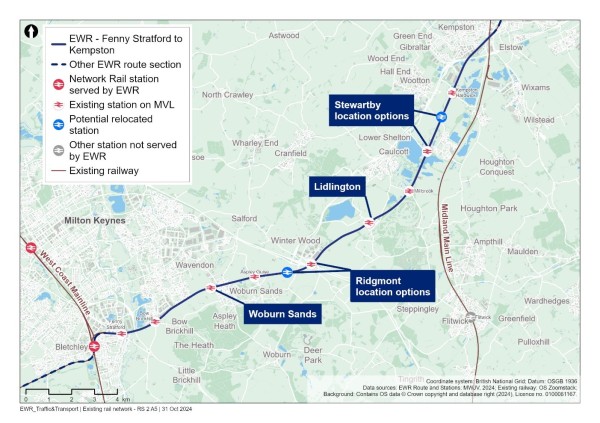
Stations and their facilities and destinations are summarised in Table 10. Services calling at each station on this route all either have an origin or destination at Bletchley or Bedford. There are few facilities at these stations, most serving smaller adjacent residential communities.
Table 10 - Fenny Stratford to Kempston existing railway stations
|
Station |
EWR service |
Facilities |
Destinations |
|
Fenny Stratford |
No |
Car park (4 spaces) |
Bletchley to Bedford and intermediate stops. |
|
Bow Brickhill |
No |
|
Bletchley to Bedford and intermediate stops. |
|
Woburn Sands |
Yes |
Bicycle storage |
Bletchley to Bedford and intermediate stops. |
|
Aspley Guise |
No |
|
Bletchley to Bedford and intermediate stops. |
|
Ridgmont |
Yes |
Toilets Car park Bicycle storage |
Bletchley to Bedford and intermediate stops. |
|
Lidlington |
Yes |
|
Bletchley to Bedford and intermediate stops. |
|
Millbrook |
No |
|
Bletchley to Bedford and intermediate stops. |
|
Stewartby |
Yes |
|
Bletchley to Bedford and intermediate stops. |
|
Kempston Hardwick |
No |
- |
Bletchley to Bedford and intermediate stops. |
Source: National Rail
Table 11 summarises the existing demand at stations along the route in this area through station entries and exits. Station entries and exits at all stations have reduced significantly since 2018/2019 (pre-covid) due to the line being closed to trains and replacement bus services provided during the year April 2022-March 2023. For comparison, both years are shown.
The station with the highest number of entries and exits is Stewartby with nearly 74,500 in 2022/2023. Kempston Hardwick has the lowest number with just below 4,500 in 2022/2023.
Table 11 - Fenny Stratford to Kempston station entries and exits
|
Station |
Entries and exits (2018 to 2019) |
Entries and exits (April 2022 to March 2023) |
|
Fenny Stratford |
26,292 |
11,350 |
|
Bow Brickhill |
43,410 |
18,532 |
|
Woburn Sands |
51,606 |
24,618 |
|
Aspley Guise |
11,636 |
4,650 |
|
Ridgmont |
31,532 |
11,570 |
|
Lidlington |
26,888 |
11,542 |
|
Millbrook |
12,504 |
6,566 |
|
Stewartby |
61,542 |
72,444 |
|
Kempston Hardwick |
9,692 |
4,458 |
Source: ORR - Table 1410.
Table 12 - Fenny Stratford to Kempston existing level crossings
|
Level Crossing Location |
Type |
|
Fenny Stratford (Simpson Road) |
Public highway manually controlled barriers, locally monitored by closed circuit television (CCTV). |
|
Bow Brickhill (V10 Brickhill Street) |
Public highway manually controlled barriers (locally monitored by CCTV). |
|
Browns Wood |
Public footpath crossing. |
|
Pony |
Public footpath or bridleway crossing with telephone with whistleboards. |
|
Woodleys Farm |
Private user worked crossing with telephone. |
|
Fisherman's Path |
Public footpath crossing. |
|
Woburn Sands (Newport Road/Station Road) |
Public highway manually controlled barriers (locally monitored by CCTV). |
|
Mill Farm |
Public footpath crossing. |
|
Sewage Farm |
Public footpath crossing. |
|
Aspley Guise (Station Road) |
Public highway manually controlled barriers (locally monitored by CCTV). |
|
Old Manor Farm |
Public footpath crossing. |
|
Berry Lane |
Private user worked crossing with telephone. |
|
Long Leys |
Private user worked crossing. |
|
Husborne Crawley 6 |
Public footpath crossing. |
|
Matey Boys |
Private user worked crossing. |
|
Husborne Crawley 10 |
Public footpath crossing with whistleboard. |
|
Ridgmont (Station Road) |
Public highway manually controlled barrier (locally monitored by CCTV). |
|
Broughton End |
Public footpath crossing with whistleboard. |
|
Forty Steps |
Public footpath crossing. |
|
Playing Field |
Public footpath crossing with whistleboard. |
|
Lidlington (Station Road) |
Public highway manually controlled barriers (locally monitored by CCTV). |
|
Pilling Farm South |
Public footpath crossing. |
|
Marston (Marston Road) |
Public highway automatic half barriers. |
|
Millbrook (Station Lane) |
Public highway manually controlled barriers (locally monitored by CCTV). |
|
Green Lane |
Public highway manually controlled barriers (locally monitored by CCTV). |
|
Stewartby Brickworks |
Private manually controlled barriers (locally monitored by CCTV). |
|
Wootton Broadmead (Broadmead Road) |
Public highway manually controlled barrier (locally monitored by CCTV). |
|
Wootton Village |
Public footpath crossing. |
|
Kempston Hardwick (Manor Road) |
Public highway automatic half barriers. |
|
Woburn Road |
Public footpath crossing with whistleboard. |
Source: Network Rail (2021).
Highway network
The primary traffic routes in the area are as follows:
- The A5, connecting Luton and Dunstable with Milton Keynes and Towcester and crossing the alignment of EWR via an underbridge between Fenny Stratford and Bow Brickhill stations.
- The A421, connecting Bletchley and Milton Keynes with Bedford, which runs broadly parallel and for the most part to the north of EWR alignment, but crosses the alignment via an overbridge on the southern edge of Bedford north of Kempston Hardwick station.
- The M1, running north-south and crossing the alignment of EWR just south of junction 13 and west of Ridgmont station.
- The A507 passes near Ridgmont but on the eastern side of the M1 to connect to Junction 13.
- The A509/A422/A428/A4280 provides an alternative road connection between Milton Keynes and Bedford further to the north of the A421 and does not cross the EWR project alignment.
- There are numerous other B roads, minor roads (C roads) and unclassified roads in the study area between Bletchley and Bedford. There are also multiple locations with level crossings providing road access across the railway as noted above.
The baseline highway network can be seen in Figure 26.
Figure 26 - Baseline highway network for the Fenny Stratford to Kempston study area
Traffic flows on motorways and major A roads in the study area (recorded as AADT by the DfT) are summarised in Table 13. The M1 is the busiest traffic route in this area, carrying 110,600 vehicles per day in both directions combined, in 2023. Away from the motorway network, the busiest traffic route is the A421, which carried 65,500 vehicles in 2023.
Table 13 - Annual Average Daily Traffic
|
Road name (location) |
Daily two-way traffic flow (2023) - vehicles |
|
M1 (East of Milton Keynes) |
110,646 (estimated) |
|
A421 (South of Bedford) |
65,582 |
|
A5 (East of Bletchley) |
39,438 |
|
A421 (North of Lower End) |
34,2833 |
|
A6 (South of Bedford) |
17,645 (estimated) |
|
A428 (West of Bedford) |
16,072 (estimated) |
|
A422 (West of Bedford) |
8,503 (estimated) |
Source: DfT - Map Road traffic statistics - Road traffic statistics (dft.gov.uk).
A review of baseline traffic flows in the area using model data has revealed that there are several roads which are currently operating at close to or over capacity in the AM or PM. These are shown in Figure 27.
Figure 27 - 2023 Baseline routes operating at or over capacity within the Fenny Stratford to Kempston study area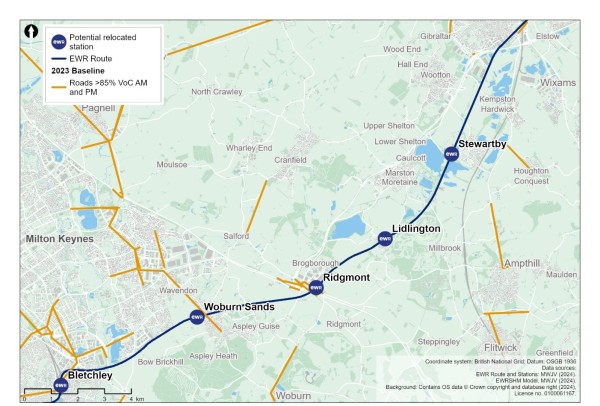
Road traffic collisions
To inform our understanding for the baseline, we have calculated the number of road traffic collisions that have occurred within the section study area, as well as the number which occur within an area which extends 100m (110 yards) from the draft Order Limits of EWR within the Fenny Stratford to Kempston Hardwick area. This information covers road traffic collisions for the five-year period between 2018 and 2022.
Within this area for Fenny Stratford to Kempston Hardwick, there was 20 fatal, 169 serious and 924 slight road traffic collisions recorded. Within the 100m (110 yards) buffer there was one fatal, nine serious and 19 slight road traffic collisions recorded[1].
Non-motorised users network
Adjacent to Woburn Sands, the A5130 Station Road to the north of the station is part of the Redway network and connects into the national cycle network route 51 which is approximately 1.5km (0.9 miles) north of the station. There is a PRoW located to the west of the station that provides a north-south NMU route. Footways are generally provided along roads in the vicinity of the station, with the main pedestrian access to the station from Station Road.
Approximately 2.5km (1.5 miles) to the north of the station is national cycle network route 51. The carriageway through Station Road level crossing includes footways for pedestrians on both sides, however the footway is only continuous on one side (eastern) beyond the immediate vicinity of the level crossing.
There are no dedicated cycling routes connecting into Lidlington station or in the immediate vicinity, although there are several bridleways and footpaths leading up to the station. The closest cycle route is national cycle network route 51 which is towards Marston Moretaine. Footways are generally provided along roads in the vicinity of the station with the main pedestrian access to the station from Station Road.
Stewartby station is located next to Marston Vale Millennium Country Park which has several PRoWs. There is a shared pedestrian and cycle path through the level crossing on Green Lane which connects into the national cycle network route 51. The Green Lane carriageway through the level crossing includes footways for pedestrians on both sides.
At Fenny Stratford, there is a footway for pedestrians across the level crossing on both sides of the carriageway. There is also a dedicated footpath from Watling Street to the station itself.
Redway super routes H10, V7 and V8 run in close proximity to the north of Fenny Stratford rail station and connects the area to the wider Milton Keynes cycle network. National cycle network route (NCN) No.6 operates on a dedicated corridor around 1km (0.6 miles) west of the Simpson Road, alongside Saxon Street and crosses Simpson at the junction with Bletcham Way. With highway improvements there could be an opportunity to connect in to NCN6.
The carriageway through the level crossing at Ridgmont includes footways for pedestrians on both sides however the footway is only continuous on the eastern side beyond the immediate vicinity of the level crossing. There are no dedicated cycling routes connecting into the station or in the immediate vicinity of the station although approximately 2.5km (1.5 miles) to the north of the station is national cycle network route 51.
Bow Brickhill station has footways through the level crossing and beyond on both sides of the carriageway. There is a shared pathway north of the station along V10 Brickhill Street, Heybridge Crescent and Bradbourne Drive. NCN6 is located to the west of the station with a link route provided around Caldecotte Lake which is located close to the station.
Public rights of way
Figure 28 presents the existing PRoW network within the section study area. There are a number of footpaths and bridleways that provide connections with the existing stations within this section that will be served by EWR services: Woburn Sands, Ridgmont, Lidlington and Stewartby.
There are 182 PRoWs within approximately 250m (273 yards) of the EWR route within which 19 cross the railway line itself. The PRoW that cross the EWR railway line are listed in Table 14.
Figure 28 - Fenny Stratford to Kempston public rights of way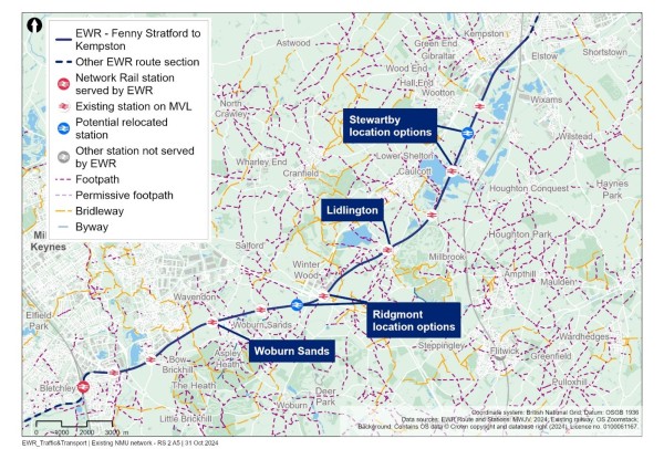
Table 14 - PRoW crossing the EWR railway line
|
PRoW number |
PRoW type |
|
079 |
Footpath |
|
004 |
Footpath |
|
008 |
Footpath |
|
014 |
Footpath |
|
002 |
Footpath |
|
003 |
Footpath |
|
3 |
Footpath |
|
13 |
Footpath |
|
12 |
Footpath |
|
6 |
Footpath |
|
10 |
Footpath |
|
2 |
Bridleway |
|
16 |
Footpath |
|
6/A6 |
Footpath |
|
1 |
Footpath |
|
13 |
Footpath |
|
5 |
Footpath |
|
1 |
Footpath |
|
1/A1 |
Footpath |
Source: OS Data.
Bus network
The bus services that serve existing railway stations that would be served by EWR trains have been identified in Table 15.
These include:
- Woburn Sands - Bus stops along the A5130 Newport Road just south-east of the existing railway station.
- Ridgmont - Bus stops located on Station Road adjacent to the existing railway station.
- Lidlington - There are existing bus stops located on Station Road and Church Street near to the station, however no regular local bus services currently serve these stops.
- Stewartby - Bus stops located on Stewartby Way adjacent to the railway station.
The baseline public transport will be reviewed in detail around new railway stations when more information is available on their location. Bus services that may be affected by level crossing closures would be assessed when more detail is available.
Table 15 - Fenny Stratford to Kempston bus services
|
Service number |
Route |
Operator |
Frequency (per hour) |
EWR Station |
|
450 |
Woburn Sands to Central Milton Keynes |
Britannia Bus |
One bus per day (11:01). |
Woburn Sands |
|
FL12 |
Maulden - Ampthill - Woburn - Milton Keynes |
Flittabus |
Community Transport (on rider request). |
Woburn Sands |
|
34 |
Central Milton Keynes, The Point - Ampthill Heights, Wagstaff Way |
Grant Palmer |
1 |
Ridgmont |
|
47 |
Tingrith - Ridgmont - Woburn - Eggington - Leighton Buzzard |
South Beds Dial-a-ride |
1 |
Ridgmont |
|
FL4 |
Silsoe - Flitwick - Milton Keynes |
Flittabus |
Community Transport (on rider request). |
Ridgmont |
|
C5 Cranfield Connect |
Cranfield - Stewartby - Wootton Upper School |
Uno |
Twice a day. |
Stewartby |
|
A1 |
Kempston – Stewartby - Cranfield - Milton Keynes |
Road Runner Community Transport |
Once a day. |
Stewartby |
Interchange at stations
Woburn Sands
The connectivity of the existing Woburn Sands station with other modes of transport is shown in Figure 29.
Figure 29 - Woburn Sands station facilities (transport)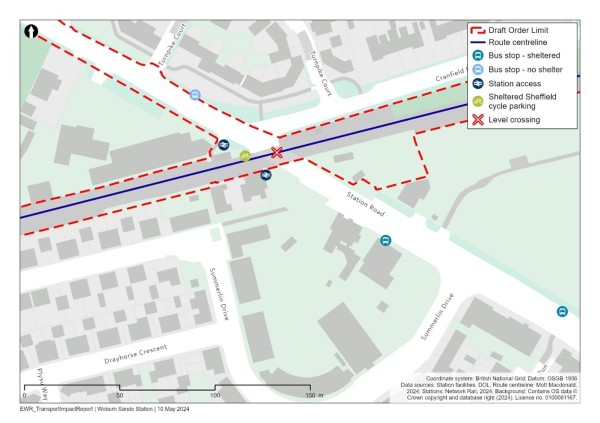
The connectivity of the existing Woburn Sands station with other modes of transport is shown in Figure 29.
The station is located to the north of the Woburn Sands urban area. Land use in the immediate vicinity of the station is predominantly residential but with a local centre immediately adjacent to the station with a mix of food and drink and recreation uses. There is no dedicated pick up and drop off facility at the station although there are streets around the station where this could occur. There is no off-street car parking provided at the station.
Sheffield stand (steel hoops) cycle parking is provided at the station with stands for 12 cycles provided at the front of the station.
Ridgmont
The connectivity of the existing station with other modes of transport is shown in Figure 30.
Figure 30 - Ridgmont station facilities (transport)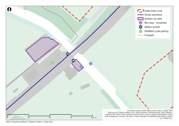
The station is located outside the village of Ridgmont, to the south of the village of Brogborough. The land use in the immediate vicinity of the site is commercial with warehousing distribution businesses, outside of this land use is predominantly agricultural. There are no dedicated drop off/pick up facilities, although there are areas locally where this could occur. There is a small amount of car parking at the station, which is associated with Ridgmont Heritage Centre attached to it, with space for approximately 15 vehicles.
Sheffield stand (steel hoops) cycle parking is provided at the station, with stands for six cycles.
Lidlington
The connectivity of the existing station with other modes of transport is shown in Figure 31.
Figure 31 - Lidlington station facilities (transport)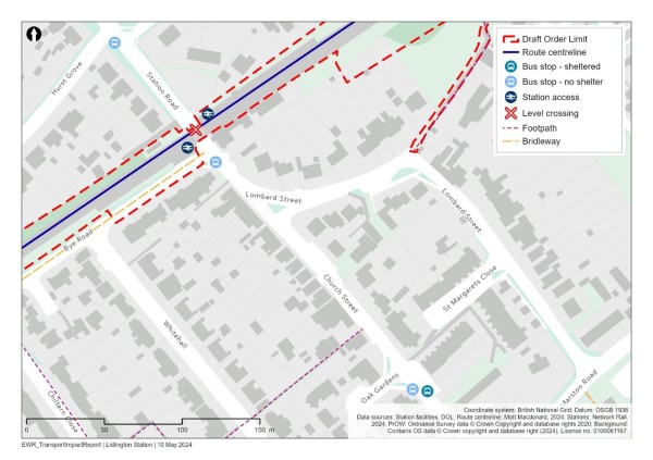
The station is located at the centre of the village of Lidlington and land use in the immediate vicinity of the station is predominantly residential. There is no dedicated drop off and pick up area at the station although there are areas around the station where this could occur. There is no car or cycle parking provided at the station.
Stewartby
The connectivity of the existing station with other modes of transport is shown in Figure 32.
Figure 32 - Stewartby Sands station facilities (transport)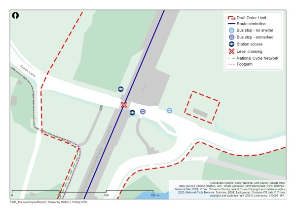
The station is located on the western edge of the village of Stewartby to the immediate north is the former Stewartby Brickworks and to the south is Stewartby Lake. There is no dedicated pick up or drop off facility at the station nor any car or cycle parking.
9.2 Future baseline
Future development and transport schemes
Changes to the transport networks would affect how they operate in the future. Additionally, changes to surrounding land use would change demand for use of these networks, meaning the future baseline situation could be dramatically different to the current 2023 baseline scenario, before the project is implemented. For all locations this could include:
- Planning applications submitted and approved for new developments or local plan allocations coming forward.
- Upgrades and improvements to transport infrastructure (highway, active travel, and public transport networks).
Specific to the Fenny Stratford to Kempston section, we have been made aware of the following schemes:
- At the end of 2023, there was an announcement in the press that Universal Studios was exploring the possibility of building a new theme park and leisure resort on a former brownfield site near Stewartby. At the time of writing this report, this project does not have planning permission and is something that will be kept under review as part of the development of the transport assessment.
- The development of Wixams station, to be in the Station Quarter at the western boundary of Wixams. Situated on the MML between Bedford and Flitwick stations, it will offer access to the local and national rail network. It is expected to be operational in advance of the project.
Changes in traffic flow
Figure 33, Figure 34 and Figure 35 show the roads which are expected to operate at close to or over capacity without the project in the years 2032, 2034 and 2049.
Figure 33 - 2032 Volume over Capacity >=85% (without the project scenario)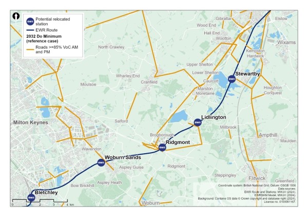
Figure 34 - 2034 Volume over Capacity >=85% (without the project scenario)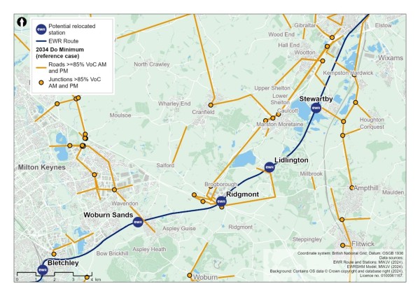
Figure 35 - 2049 Volume over Capacity >=85% (without the project scenario)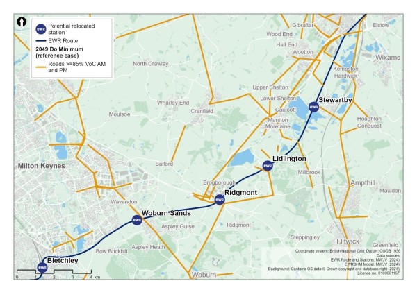
Figure 33, Figure 34 and Figure 35 show that between 2032 and 2049 there are many additional roads that would operate at close to or over capacity, including along Station Lane to the east and west of Millbrook station, Flitwick Road north of Ampthill, Lower Shelton Road through Lower Shelton village, the B5704 south of Ridgemont station and Woburn Road south-east of Woburn Sands.
9.3 Project proposals
This route section covers approximately 23km (14 miles) of the existing Marston Vale Line (MVL) between Saxon Street dual carriageway and Ampthill Road in Kempston. The MVL, which runs between Bletchley and Bedford, is currently used by London Northwestern Railway passenger trains and freight trains and includes nine existing stations.
Table 16 - MVL Station Options
|
Concept 2 (Consolidated Stations Option) |
Concept 1a (Existing Stations Option) |
|
The nine existing stations between Fenny Stratford to Kempston would be consolidated into four new stations (Woburn Sands, Ridgmont, Lidlington and Stewartby). The other five would be closed.
|
All nine of the existing stations would be retained with minor enhancements and upgrades as necessary.
|
Concept 2 would consolidate the nine existing stations along the MVL to four new stations, with up to three East West Rail services calling at all four stations every hour. The assessment presented in this chapter is based on this proposal because this option would have the most significant transport impacts. A final decision has not been taken on this approach and will be subject to further work and technical assessment, taking account of feedback from this consultation. Within Concept 2 there remain options under consideration, which are described in this chapter.
A summary of the environmental considerations and relative merits of the station concepts that have been considered is set out in the Technical Report.
The proposed works are summarised as follows:
- Stations at Woburn Sands, Ridgmont, Lidlington and Stewartby would be replaced by new or enlarged stations to accommodate East West Rail services.
- Five existing stations at Fenny Stratford, Bow Brickhill, Aspley Guise, Millbrook and Kempston Hardwick would be closed.
- Upgrading the existing single track to two track over about 1.7km (1 mile) approximately between Saxon Street and the A5.
- Improved or new access roads for track maintenance at various locations across the route section.
- Changes to the 30 level crossings in this area, from retained; upgraded; closed and diverted; closed and replaced by bridge crossings and associated diversions of rights of way; or closed without alternative provision.
- Construction of various drainage and water storage ponds (referred to as balancing ponds) along the route section.
- Various utility diversions including overhead power lines and below ground gas pipes.
- Upgrades to existing railway signalling, telecommunications and traction power facilities.
- Construction of passing loops to allow faster passenger trains to overtake slower trains (see options table, Table 16).
The proposed EWR passenger train service pattern between Bletchley and Bedford, would be three trains per hour in each direction, plus up to two trains an hour between Stewartby and Cambridge. Line speed would increase to 75mph for passenger trains.
Construction compounds and movements
Construction compounds in the Fenny Stratford to Kempston section would generally be located at existing stations or at locations requiring new or replacement structures.
The Fenny Stratford to Kempston works is less extensive than those proposed further east and as such could be delivered more quickly.
Construction traffic routes to support the delivery of these works would be strictly controlled and the route to the nearest point of connection to the strategic road network (motorway and major A roads) would be assessed and defined to reduce the impact to the local area and stakeholders.
The majority of construction HGV movements in this section would use Bletcham Way to access the A5 in Bletchley or the A421 and A507 to access the M1 at Junction 13 east of Bletchley. Some construction traffic at the eastern end of the section would access the A421 at Beancroft Road or Woburn Road using Bedford Road or Woburn Road.
9.4 Potential impacts
A comparison has been undertaken between the 2032, 2034 and 2049 reference cases (no project) and the corresponding with project scenarios for those years, to determine what links become over capacity when project traffic is added to the network, including the reassignment of non-construction traffic.
Figure 36 shows the roads that become at or over capacity in 2032, because of construction traffic related to the project. The roads identified include:
- The A5130 Newport Road north of Wavedon.
- The A421 south of Kempston.
- Cemetery Road, West Kempston.
- Tithe Road - West End.
Figure 36 - Comparison of 2032 reference case (no project) vs 2032 with project: additional roads with a Volume over Capacity >=85% 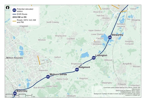
Figure 37 shows the additional roads with a Volume over Capacity of greater than or equal to 85% in 2034, because of the project. These include:
- A short section of the A5 at Bletchley.
- A short section of the A509 just south of junction 14 of the M1.
- The A5030 Woburn Road south of Woburn Sands.
- Local road links at Lidlington and Marston Moretaine.
Figure 37 - Comparison of 2034 reference case (no project) vs 2034 with project: additional roads with a Volume over Capacity >=85% 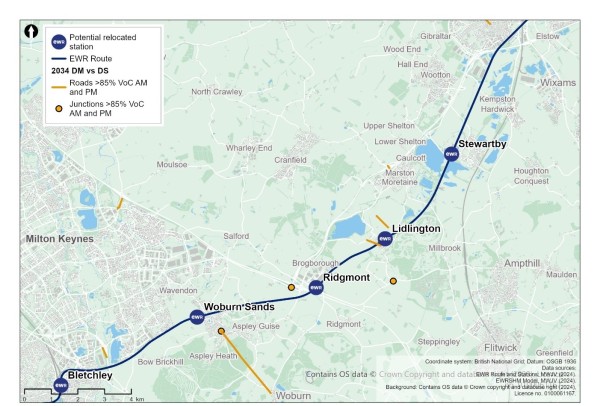
Figure 38 shows the additional roads with a VoC of greater than or equal to 85% in 2049, because of the project. These include:
- The A5030 Woburn Road south of Woburn Sands.
- Local road links at Lidlington.
- Roads within Broughton in the vicinity of the M1 Junction 14.
- H6 Childs Way north of Middleton.
- Local network in vicinity of Ridgmont station.
- Local route in the vicinity of East End and Wharley End.
- M1 south of Junction 13.
Figure 38 - Comparison of 2049 reference case (no project) vs 2049 with project: additional roads with a Volume over Capacity >=85% 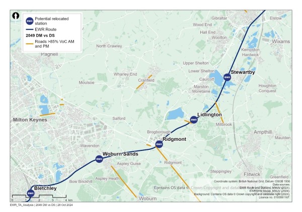
In addition to links which become over capacity in the ‘with project’ scenarios, there would be links that are already operating over capacity in the ‘no project’ scenarios, which are assessed to be pushed further over capacity in the ‘with project’ scenarios. These are not shown in the figures but would form part of further assessment in the TA and subsequent discussions with stakeholders regarding mitigation.
Based on the current design maturity, the following potential impacts in Table 17 could be realised within this study area section.
Table 17 - Fenny Stratford to Kempston potential transport impacts (Concept 2)
|
Mode/Who |
Phase |
Change |
Potential impact prior to any mitigation |
|
NMUs |
Construction |
Temporary construction works, including traffic management or changes to utility infrastructure required for the project, may affect NMU access and movement. |
In some places, existing level crossings, user worked crossings and footbridges or underpasses crossing the railway may be closed temporarily to allow construction to be safely carried out and this may result in diversions. Temporary traffic management may result in diversion routes or temporary closure of crossing points or footways. |
|
Highway (to include buses) |
Construction |
Construction of new stations and track enhancements leading to temporary impacts in local areas including construction traffic movements, temporary traffic management and diversions. |
This may lead to delay on the highway network to pass through temporary traffic management measures, or use of diversion routes. The extents of these potential impacts have not yet been determined. The CTMP and CoCP will include provisions to reduce the impacts of these works on road users. |
|
Highway and rail |
Construction |
Construction of two new single-track bridges. One adjacent to the existing bridge over the River Ouzel and a second adjacent to the existing bridge over the A5 which is part of the SRN. |
There would be a requirement for staged closures of the railway and highway to complete these new bridge structures. This would result in journey delay and the requirement to use diversion routes (for highway users) or potentially rail replacement buses (for rail users). |
|
Highway |
Construction |
Construction traffic movements on the network. |
Temporary traffic delay and/or congestion on the highway network, in particular routes which accommodate construction traffic. The CTMP and CoCP will include provisions to reduce the impacts of these works on road users. Interim modelling outputs provide initial information on potential locations of impact. |
|
Rail users |
Construction |
Some construction activities may require temporary suspension of rail services, for example taking short possessions of the railway to close PRoW level crossings. |
Alternative transport would be provided where possible, in consultation with train operating companies and other affected stakeholders. |
|
Highway |
Operation |
The potential new EWR Ridgmont station is in the immediate vicinity of the M1 Junction 13 with a localised change of movement patterns expected at this junction. |
The project includes a new station offering a large park and ride interchange hub which can intercept longer distance trips at this point. Considering mode shift to rail there is expected to be a reduction in total trips and vehicle kilometres travelled on the strategic road network in comparison with the baseline forecast scenario, but there would be a localised increase in turning movements at the M1 Junction 13. This will be discussed with National Highways. |
|
Highway, NMUs and Buses |
Operation |
Closure of some level crossings. For remaining level crossings, additional barrier down time. |
All users will be required to utilise alternative routes which will lead to an increase in journey distance and time. The suitability of the routes for all users will be assessed once the design is confirmed to ensure the proposed diversion routes are suitable, with mitigation proposed where required to enhance routes. At this stage, closure and subsequent route diversions are expected at some level crossings. |
|
NMUs |
Operation |
Existing PRoW routes which cross the proposed route alignment may require new crossing facilities or closure and associated diversions. |
This could lead to an increase in journey distance and journey time for NMUs. The suitability of diversion or alternative routes for all NMU users would be reviewed to ensure the proposed diversion routes are suitable, with mitigation proposed where required to enhance routes. |
|
Rail users |
Operation |
Increased train frequency on the line and revised travel patterns in response to closure of existing stations and creation of new EWR stations. |
Improved journey times and frequencies for rail passengers. |
|
Highway |
Operation |
Provision of new rail services would provide travel choice for longer distance trips supporting mode shift from car to rail. Additionally new or enhanced stations providing local access to rail services may also alter local trip patterns. |
Changes to highway demand due to mode shift from car to rail, or a change in local trip patterns with the opportunity to travel to (new) local stations to access enhanced or new rail services. This could result in some localised delay and congestion or see a reduction in traffic in some locations. Options for mitigation to provide additional capacity at locations will be reviewed and discussed with key stakeholders. |
|
Rail users |
Operation |
The potential closure of five existing stations along the route (Fenny Stratford, Bow Brickhill, Aspley Guise, Millbrook, and Kempston Hardwick) would require current rail users of these stations to travel differently. |
This may lead to increased journey times and distances, and/or a change in travel mode for some users. Improved connectivity and accessibility could also lead to mode shift (change in travel behaviours) and see a reduction in highway traffic, leading to less congestion and highway journey delay. |
[1] STATS19, DfT, 2018-2022.
10. Bedford
10.1 Baseline area
The area comprises the urban area of Bedford, with the EWR route approaching Bedford via the Marston Vale Line (MVL) from the south and passing to the north towards Clapham. This area is located entirely within the Bedford local authority area.
Current baseline
Rail network
Within the study area there are two existing rail stations along the EWR alignment. Bedford St Johns is located on a single-track railway line as it changes from a two-tracked railway to the south of the station. The MVL terminates at Bedford station, where there is an opportunity for interchange with the Midland Main Line (MML) and East Midlands Railway (EMR).
Bedford station is a stop on the MML into London St. Pancras station. Train services are provided by both East Midlands Railway and Thameslink.
The existing rail network in the section study area can be seen in Figure 39.
Figure 39 - Existing rail network in the Bedford study area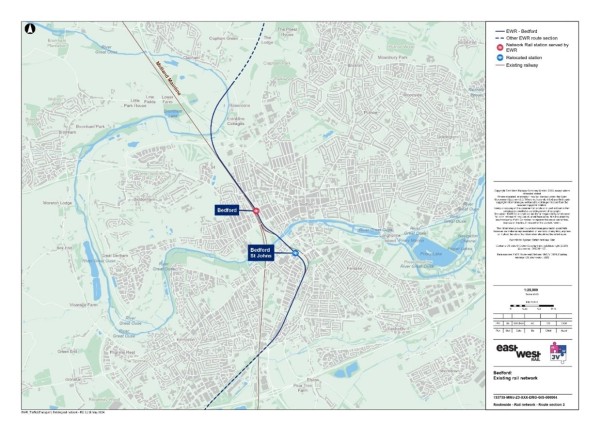
These stations and their facilities and destinations are summarised in Table 18.
Table 18 - Bedford existing railway stations
|
Station |
EWR service |
Facilities |
Destinations |
|
Bedford St Johns |
Yes |
· Car park (120 spaces) · Bicycle storage |
· Bletchley · Bedford |
|
Bedford station |
Yes |
· Ticket office · Toilets · Waiting room · Car park (654 spaces*) · Bicycle storage |
· Brighton · Corby · Bletchley · Three Bridges · London St Pancras International · East Grinstead |
* Official station operated car park, with additional car parking available in the adjacent Bedford Borough Council car park (Ashburnham Road). Source: National Rail and APCOA Parking UK.
Table 19 summarises the existing demand at stations along the route in this area through station entries and exits. Bedford station has over 3,000,000 entries and exits whereas Bedford St Johns station has just over 141,500.
Table 19 - Bedford section station entries and exists
|
Station |
Entries and exits (April 2022 to March 2023) |
|
Bedford St Johns |
141,586 |
|
Bedford |
3,035,712 |
Source: ORR - Table 1410.
There are no level crossings within this study this area, other than a private crossing within the Jowett Sidings south of Bedford station.
Highway network
The route passes through the urban area of Bedford mainly along the alignment of the existing railway north-south.
The main road connection linking Bedford and Cambridge is the A421 and the A428 via the A1 at Wyboston, which also crosses the EWR alignment at multiple locations. The A603 also provides a connection between Bedford and Sandy to the south. The EWR alignment would also cross the A6 and the A4280 to the north of Bedford, and the A10 at Harston.
The A6, connecting Luton with Bedford crosses the EWR alignment at Bedford St Johns station.
The baseline highway network can be seen in Figure 40.
Figure 40 - Baseline highway network for the Bedford study area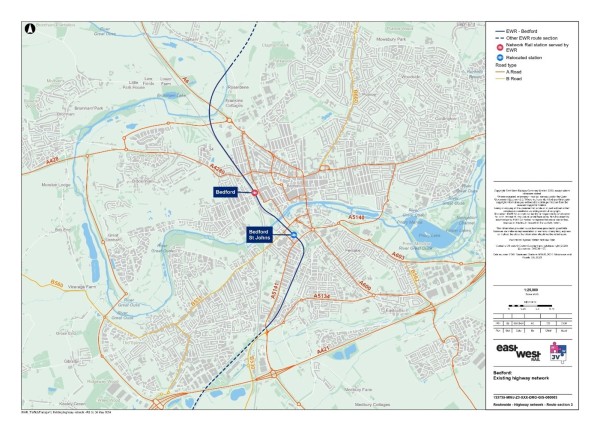
Traffic flows on motorways and major A roads in the study area (recorded as AADT by the DfT) are summarised in Table 20.The A4280 carried almost 11,800 vehicles per day through the study area in 2023 in both directions combined and the A421 carried around 35,800 in 2023.
Table 20 - Annual Average Daily Traffic
|
Road name (location) |
Daily two-way traffic flow (2023) - vehicles |
|
A4280 (east of Bedford) |
11,792 (estimated) |
|
A421 (north of Great Barford) |
35,823 (estimated) |
|
A6/A5141 (north of A421) |
32,574 (estimated) |
|
A5141 Kempson Road (south of Ouse) |
17,023 (estimated) |
|
A4280 West of railway (Broham Road) |
15,917 (estimated) |
|
A6 Great Ouse Way |
17,299 (estimated) |
Source: DfT - Map Road traffic statistics - Road traffic statistics (dft.gov.uk).
A review of baseline traffic flows in the area using model data has revealed that there are several roads which are currently operating at close to or over capacity in the AM or PM. These are shown in Figure 41.
Figure 41 - 2023 Baseline routes operating at or over capacity within the Bedford study area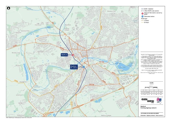
Road traffic collisions
To inform our understanding for the baseline, we have calculated the number of road traffic collisions that have occurred within the section study area, as well as the number which occur within an area which extends 100m (110 yards) from the draft Order Limits of EWR within the Bedford study area. This information covers road traffic collisions for the five-year period between 2018 and 2022.
Within this Bedford study area, there were seven fatal, 144 serious and 620 slight road traffic collisions recorded. Within the 100m (110 yards) buffer, there were no fatal, seven serious and 41 slight road traffic collisions recorded[1].
Non-motorised users network
Adjacent to Bedford St Johns station, a numbered cycle route (21, 22, 23)[2] is provided on Kingsway and also on Britannia Road (24). There are several nearby routes that can be used by rail passengers to access the station from the wider area. Pedestrian access to the station is from Melbourne Street via the Melbourne Street car park access. Access to the south and west of the station by walking is restricted by the difference in levels and lack of a railway crossing.
There are no dedicated cycling routes connecting into Bedford station or in the immediate vicinity of the station. There are several nearby routes that can be used by rail passengers to access the station from the wider area. Immediately adjacent to the station there is a short contra-flow cycle lane on Woburn Road that provides cycle access from the east. Pedestrian access to the station is from the A5181 Ashburnham Road to the east of the railway line. A zebra crossing is located on the A5181 Ashburnham Road close to the station entrance. This can be used by passengers heading towards Bedford town centre. There is an implied zebra crossing across the station pick up and drop off access.
Public rights of way
Figure 42 presents the existing PRoW network within the section study area.
There are two PRoWs within 250m (273 yards) of the EWR route (route 1 and 43). These are joined either side of the railway via a footbridge. There are no PRoW within close proximity to the stations.
Figure 42 - Bedford public rights of way
Bus network
The bus services that serve existing railway stations that are proposed to be EWR stations have been identified in Table 21. These include:
- Bedford St Johns station - The closest bus stop to the station is on the A600 Kingsway, which is a walk of approximately 500m (546 yards).
- Bedford station - Local bus services operate along the A5181 Ashburnham Road, with stops located on both sides of the road close to the entrance. The northbound stop includes three bus stands, two of which are sheltered, as part of a small interchange facility. The southbound stop is a standard stop with no shelter.
Table 21 - Bedford bus services
|
Service number |
Route |
Operator |
Frequency (per hour) |
EWR Station |
|
2 |
Bedford to Flitwick |
Stagecoach East |
1 |
Bedford St Johns |
|
3 |
Bedford to Fenlake |
Stagecoach East |
2 |
Bedford St Johns |
|
9/9A/9B/9C/9D |
Bedford to Shortstown/Hitchen |
Stagecoach East |
Four services per hour in either direction, two of which continue to Hitchin. |
Bedford St Johns |
|
44 |
Flitwick to Bedford |
Grant Palmer |
1 |
Bedford St Johns |
|
68 |
Bedford to Ampthill |
Grant Palmer |
1 |
Bedford St Johns |
|
72 |
Bedford to Biggleswade |
Grant Palmer |
1 |
Bedford St Johns |
|
73 |
Bedford to Biggleswade |
Grant Palmer |
Every two hours. |
Bedford St Johns |
|
74 |
Bedford - Biggleswade - Hitchin |
Grant Palmer |
1 |
Bedford St Johns |
|
MK1 |
Bedford to Luton |
Stagecoach |
1 |
Bedford St Johns |
|
W1 |
Bedford - Southill and Stanford - Broom - Langford - Henlow - Stotfold - Meppershall |
Wanderbus |
Once a day. |
Bedford St Johns |
|
W2 |
Bedford - Gravenhurst - Shillington - Lower Stondon - Clifton - Meppershall |
Wanderbus |
Once a day. |
Bedford St Johns |
|
41 |
Bedford to Northampton |
Stagecoach East |
Every two hours. |
Bedford |
|
50 |
Bedford - Rushden |
Stagecoach East |
Every two hours. |
Bedford |
Interchange at stations
Bedford St Johns
The connectivity of the station with other modes of transport is shown in Figure 43.
Figure 43 - Bedford St Johns station facilities (transport)
The existing station is located to the south of Bedford town centre to the east of Bedford Hospital. Apart from the hospital, surrounding land use is a mixture of residential and commercial. There are no dedicated drop off or pick up facilities at the station, although there are areas nearby where this could occur. There is a car park with capacity for 120 vehicles to the immediate west of the station. Opportunities for on-street parking outside of the station are limited.
Sheffield stand (steel hoops) cycle parking is provided at the station with eight stands.
Bedford station
The connectivity of the station with other modes of transport is shown in Figure 44.
Figure 44 - Bedford station facilities (transport)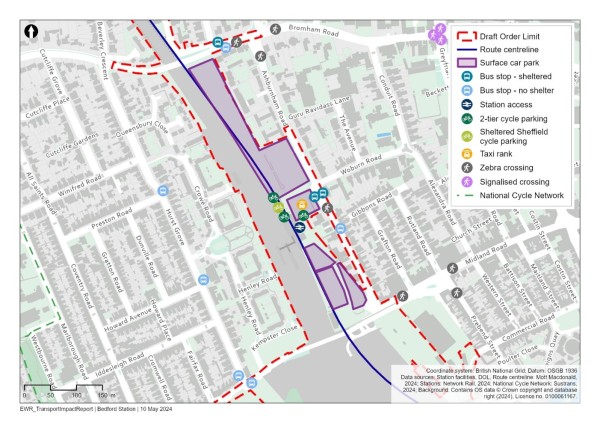
The station is located to the west of Bedford town centre. Land use to the west of the station is predominantly residential with a mix of commercial and residential use to the east. There are dedicated pick up and drop off facilities outside the station. Surface car parks with a combined capacity of approximately 980 spaces are provided outside the station, including two operated by APCOA Parking Limited and Ashburnham Road car park operated by Bedford Borough Council. Opportunities for on-street parking are limited.
Sheffield stand (steel hoops) cycle parking is provided at the station with stands for 588 cycles at the front of the station.
10.2 Future baseline
Future development and transport schemes
Changes to the transport networks would affect how they operate in the future. Additionally, changes to surrounding land use would change demand for use of these networks. This means the future baseline situation could be dramatically different to the current 2023 baseline scenario, before the project is implemented. For all locations, this could include:
- Planning applications submitted and approved for new developments or local plan allocations coming forward.
- Upgrades and improvements to transport infrastructure, including (highway, active travel and public transport networks).
Changes in traffic flow
Figure 45, Figure 46 and Figure 47 show the roads which are expected to operate at close to or over capacity without the project in the years 2032, 2034 and 2049.
Figure 45 - 2032 Volume over Capacity >=85% (without the project scenario)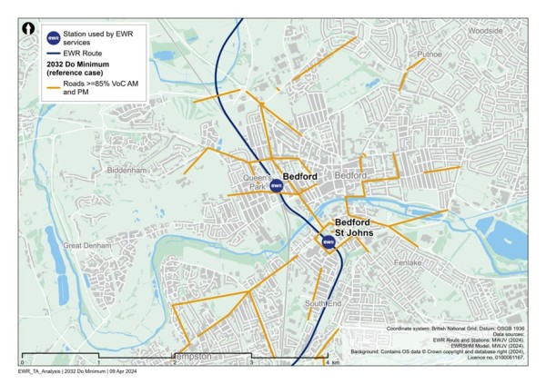
Figure 46 - 2034 Volume over Capacity >=85% (without the project scenario)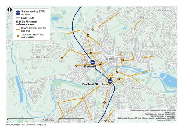
Figure 47 - 2049 Volume over Capacity >=85% (without the project scenario)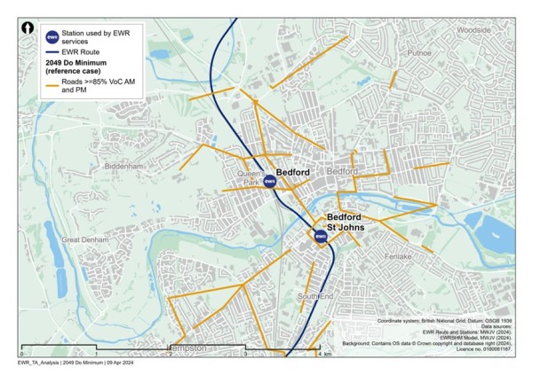
Figure 45, Figure 46 and Figure 47 show that between 2032 and 2049, there are many additional roads that will operate at close to or over capacity, including along Tavistock Street north of Bedford, The Embankment east of Bedford and along Kingsway near Bedford St Johns station.
10.3 Project proposals
The EWR route through Bedford is approximately 5.4km (3.4 miles) long, extending north between Ampthill Road in Kempston, and Clapham Road south-east of Clapham village, next to the River Great Ouse. As well as sections of new track along the existing MVL up to Bedford station and modifications to the existing track and two new tracks alongside the Midland Main Line north of Bedford station, wider modifications would be required to rail infrastructure where sidings are displaced by the EWR proposals. Various road realignments would also be necessary.
The proposed works are summarised as follows:
- A new two-track railway to be constructed in the existing rail corridor between the Sandhurst Road footbridge and Bedford station that would remove the existing single MVL track between these two points.
- A new relocated station at Bedford St Johns closer to Bedford Hospital to replace the existing station which would be removed.
- Construction of new sidings at Cauldwell Walk to replace those displaced at Jowett sidings to make space for the railway tracks as they approach Bedford station.
- Construction of new railway infrastructure at Bedford station to allow EWR passengers to interchange with other train services, such as a new station plaza, new footbridges and replacement car parking.
- Construction of two new tracks alongside the Midland Main Line north from Bedford station, which would then diverge east to follow a new rail corridor using a new viaduct over Paula Radcliffe Way and the River Great Ouse.
- Works to roads in the area to enable the railway to be built and operated, including the realignment of Ampthill Road, Cauldwell Street, Ford End Road, Bromham Road and A6 Great Ouse Way.
- Construction of drainage and water storage ponds (referred to as balancing ponds) along the route section.
- Diversions of various utilities, including overhead power lines.
The proposed EWR passenger train service pattern through Bedford is three trains per hour in each direction between Bletchley and Bedford and two trains per hour in each direction between Stewartby and Cambridge via Bedford. This is in addition to the existing passenger and freight services on lines alongside EWR through central Bedford.
Construction compounds and movements
Two main construction compounds are proposed for the South Bedford and Bedford St Johns. The first compound would be situated within the existing industrial estate, at Caudwell Walk, to support the delivery of the new Cauldwell Sidings, and highway access to the sidings. The second compound would be located adjacent to the existing Bedford St Johns station at the Britannia Road car park, both north and south of Ampthill Road. This compound would support the delivery of the new EWR tracks and rail systems as far as the existing bridge over the River Great Ouse. It would also support construction of the new relocated Bedford St Johns station and parking, and the reconstruction of both Ampthill Road and Cauldwell Street road overbridges.
Construction traffic routes to support the delivery of these works would be strictly controlled and the route to the nearest point of connection to the strategic road network (motorway and major A roads) would be assessed and defined to reduce the impact to the local area and stakeholders.
The majority of construction traffic would utilise the A421 and associated shortest route to the site compounds. Access to Bedford Hospital for emergency vehicles, to the town centre and Bedford St Johns station would be maintained throughout construction.
As construction compounds would be, in some cases, located at stations, there would be impacts to station access for passengers. These impacts would be controlled by provisions within the CTMP and CoCP and coordinated with train operating companies where access to stations is expected to be impacted.
Some construction activities could require temporary suspension of rail services. Alternative transport would be provided where possible, in consultation with train operating companies.
Potential impacts
A comparison has been undertaken between the 2032, 2034 and 2049 reference cases (no project) and the corresponding with project scenarios for those years, to determine what links become over capacity when project traffic is added to the network.
Figure 48 shows the roads that become at or over capacity in 2032, due to construction traffic related to the project.
The roads identified include:
- The A4280 Bromham Road, west of Bedford station.
- Clapham Road, north of Bedford station.
- St Peter’s Street at Bedford centre.
- The A4280 Goldington Road, east of Bedford station.
- The Embankment east of Bedford station.
- Kingsway and Rope Walk near Bedford St Johns station.
- The A600 London Road and Elstow Road, south of Bedford St Johns station.
- Elstow Road and Spring Road, south of Bedford St Johns station.
- The A603 Cardington Road, east of Bedford St Johns station.
Figure 48 - Comparison of 2032 reference case (no project) vs 2032 with project: additional roads with a Volume over Capacity >=85%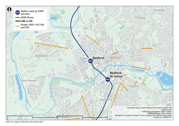
Figure 49 shows the additional roads with a VoC of greater than or equal to 85% in 2034 because of the project. These include:
- Roads local, east of Bedford station.
- Tavistock Street, east of Bedford station.
- Manton Lane, north of Bedford station.
- The A600, east of Bedford station.
- Roads local to the east of Bedford St Johns station.
- The Embankment, east of Bedford station.
- The A603 Cardington Road, east of Bedford St Johns station.
Figure 49 - Comparison of 2034 reference case (no project) vs 2034 with project: additional roads with a Volume over Capacity >=85%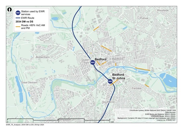
Figure 50 shows the additional roads with a VoC of greater than or equal to 85% in 2049, because of the project. These include:
- The A4280 Broham Road, west of Bedford station.
- Roads local to the east of Bedford station.
- Clapham Road, east of Bedford station.
- The A600, east of Bedford station.
- Roads local to the east of Bedford St Johns station.
- The A4280 Goldington Road east of Bedford station.
Figure 50 - Comparison of 2049 reference case (no project) vs 2032 with project: additional roads with a Volume over Capacity >=85%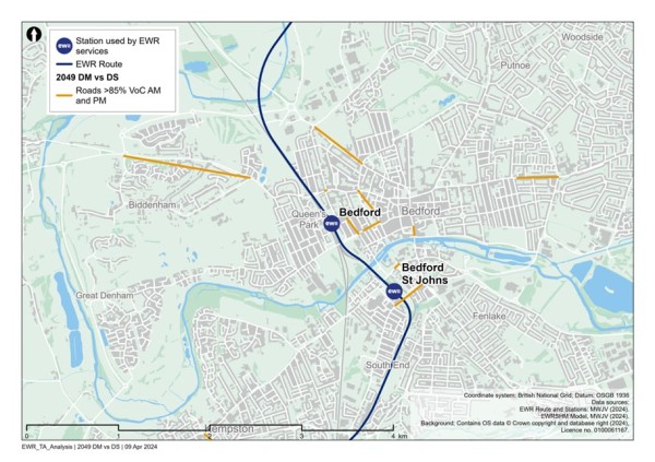
In addition to links which become over capacity in the ‘with project’ scenarios, there would be links that are already operating over capacity in the ‘no project’ scenarios, which are assessed to be pushed further over capacity in the ‘with project’ scenarios. These are not shown in the figures but would form part of further assessment in the TA and subsequent discussions with stakeholders regarding mitigation.
Based on the current design maturity, the following potential impacts in Table 22 could be realised within this study area section.
Table 22 - Bedford potential impacts (transport)
|
Mode/Who |
Phase |
Change |
Potential impact prior to any mitigation |
|
Highway |
Construction |
Highway bridge replacements at Ampthill Road, Cauldwell Street and Ford End Road. Bridge widening at Bromham Road. New bridges and local realignment at the A6 Great Ouse Way and the A6 Paula Radcliffe Way. |
This could lead to journey delay and increases in journey distance to utilise temporary diversion routes. The suitability of the temporary diversion routes for all users will be assessed once the design is confirmed. |
|
NMUs |
Construction |
Temporary construction works, including traffic management, changes to utility infrastructure required for the project, may affect NMU access and movement. |
In some places, existing crossings and footbridges or underpasses crossing the railway may be closed temporarily to allow construction to be safely carried out and this may result in diversions. Temporary traffic management may result in diversion routes or temporary closure of crossing points or footways. |
|
NMUs |
Construction |
Temporary traffic management may be required where the project affects the highway network. |
This may lead to delay on the highway network to pass through temporary traffic management measures, or use of diversion routes. The extents of these potential impacts have not yet been determined. The CTMP and CoCP will include provisions to reduce the impacts of these works on road users. |
|
Highway |
Construction |
Construction traffic movements on the network. |
Temporary traffic delay and/or congestion on the highway network, in particular routes which accommodate construction traffic. The CTMP and CoCP will include provisions to reduce the impacts of these works on road users. Interim modelling outputs provide initial information on potential locations of impact. |
|
Rail users |
Construction |
Some construction activities may require temporary suspension of rail services. |
Alternative transport would be provided where possible, in consultation with train operating companies and other affected stakeholders. |
|
Rail users |
Construction |
Due to the need to relocate and reconstruct Bedford St Johns railway station, it is expected that this station will experience disruption to services and access. |
It is expected that services through Bedford St Johns station will be subject to occasional short-term disruption. This could lead to journey delay and increases in journey time. |
|
Highway |
Operation |
Increased vehicle movements associated with access to station car parks. Access from Melbourne Street to a new station car park for Bedford St Johns station and from Midland Road for Bedford station. |
Increased vehicle movements along Melbourne Street and Midland Road, as well as changed vehicle movements on the wider highway network to access the car parks. |
|
Highway |
Construction |
Construction work for the permanent realignment of the A6 The Great Ouse Way and Paula Radcliffe Way to accommodate EWR viaduct. |
This could potentially mean changes in journey distance travel times or use of alternative routes during construction of the new alignment. The majority of the route will be constructed offline to minimise traffic impacts. |
|
Rail users |
Operation |
Enhancements to Bedford St Johns station would provide better interchange options with NMU routes and buses for last mile connectivity. |
Improved connectivity and accessibility could lead to mode shift (change in travel behaviours) and see a reduction in highway traffic, leading to less congestion and highway journey delay. |
|
Rail users |
Operation |
Increased train frequency on the line and revised travel patterns in response to closure of existing stations and creation of new EWR stations. |
Improved journey times and frequencies for rail passengers. |
|
Highway |
Operation |
Provision of new rail services will provide travel choice for longer distance trips supporting mode shift from car to rail. Additionally new or enhanced stations providing local access to rail services may also alter local trip patterns. |
Changes to highway demand due to mode shift from car to rail, or a change in local trip patterns with the opportunity to travel to the proposed new local stations to access enhanced or new rail services. This could result in some localised delay and congestion or see a reduction in traffic in some locations. Options for mitigation to provide additional capacity at locations will be reviewed and discussed with key stakeholders. |
[1] STATS19, DfT, 2018-2022.
[2] Bedford and Kempston Cycling Map. Accessed via: Cycle lanes and routes | Bedford Borough Council.
11. Clapham Green to Colesden
11.1 Baseline area
The area runs along the proposed East West Rail (EWR) alignment from Clapham Green in the west, located to the north-east of the Bedford urban area to Colesden west of Tempsford. This area is located entirely within the Bedford local authority area.
Current baseline
Rail network
There is no existing railway network or stations between Clapham and Colesden. The existing Midland Main Line (MML) runs to the west of Clapham alongside the A6 just on the boundary of the study area.
Highway network
The A6 runs to the west of Clapham connecting to Bedford to the south via Clapham Road. The B660 crosses the route between Clapham and Colesden. The A421 is located to the south of Colesden and connects to the A1 via Black Cat roundabout.
The baseline highway network can be seen in Figure 51.
Figure 51 - Baseline highway network for the Clapham Green to Colesden study area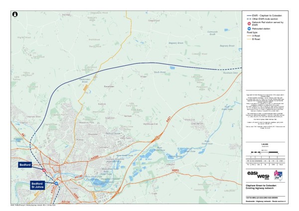
Traffic flows on key roads in the study area (recorded as annual average daily traffic (AADT) by the DfT) are summarised in Table 23. The A421 carried just over 35,800 vehicles per day through the study area in 2023 in both directions combined and the A6 carried around 17,300 in 2023.
Table 23 - Annual Average Daily Traffic
|
Road name (location) |
Daily two-way traffic flow (2023) - vehicles* |
|
B660 North of Brickhill* 2019 data |
5,557 |
|
A421 |
35,823 (estimated) |
|
A6 |
17,299 (estimated) |
Source: DfT - Map Road traffic statistics - Road traffic statistics (dft.gov.uk)
A review of baseline traffic flows in the area using model data has revealed that there are currently no roads which are operating at close to or over capacity within this study area.
Non-motorised users network
Figure 52 presents the existing PRoW network within the section study area.
There are 30 PRoWs within approximately 250m (273 yards) of the EWR route within which 17 cross the railway line itself. The PRoWs that cross the EWR railway line are listed in Table 24.
Figure 52 - Clapham Green to Colesden public rights of way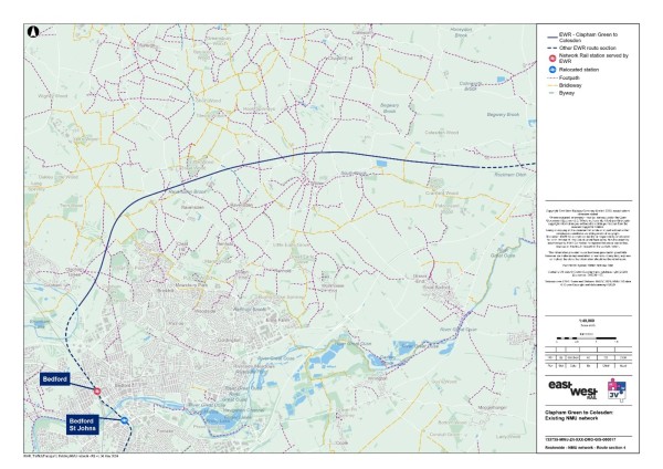
Table 24 - PRoW crossing the EWR railway line
|
PRoW number |
PRoW type |
|
9 |
Footpath |
|
24 |
Footpath |
|
5 |
Footpath |
|
6 |
Footpath |
|
54 |
Bridleway |
|
47 |
Footpath |
|
46 |
Footpath |
|
29 |
Footpath |
|
61 |
Bridleway |
|
35 |
Footpath |
|
22 |
Footpath |
|
16 |
Footpath |
|
33 |
Bridleway |
|
27 |
Footpath |
|
24 |
Footpath |
|
16 |
Bridleway |
|
15 |
Footpath |
Source: OS Data.
Bus network
Due to there being no existing stations that will be EWR stations within this section there is currently no interface between rail and bus for multi-modal trips.
Grant Palmer run a number of rural buses in the region, some of which would cross the project alignment, including the 27 which loops from Bedford round via Ravensden and Wilden, the 28 from Bedford to Kimbolton, the 28A which links between Bedford and Little Staughton and the 28E between Bedford and Riseley.
11.2 Future baseline
Future development and transport schemes
Changes to the transport networks will affect how they operate in the future. Additionally, changes to surrounding land use will change demand for use of these networks, meaning the future baseline situation could be dramatically different to the current 2023 baseline scenario, before the project is implemented. For all locations, this could include:
Planning applications submitted and approved for new developments or Local Plan allocations coming forward.
General small-scale upgrades and improvements to transport infrastructure (highway, active travel and public transport networks).
Changes in traffic flow
Figure 53, Figure 54 and Figure 55 show the roads which are expected to operate at close to or over capacity without the project in the years 2032, 2034 and 2049.
Figure 53 - 2032 Volume over Capacity >=85% (without the project scenario)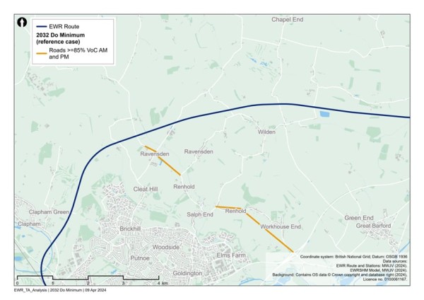
Figure 54 - 2034 Volume over Capacity >=85% (without the project scenario)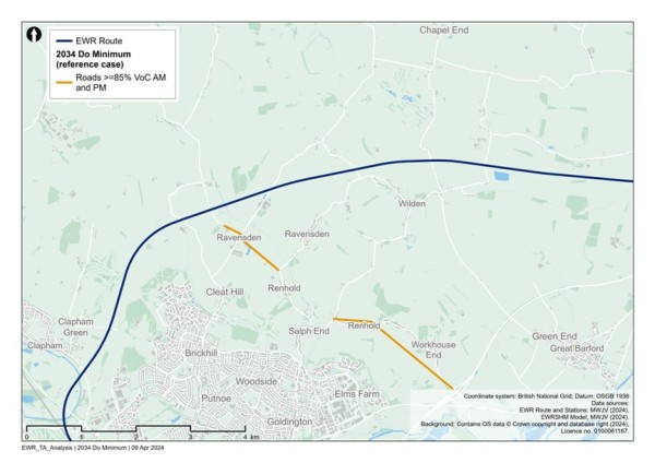
Figure 55 - 2049 Volume over Capacity >=85% (without the project scenario)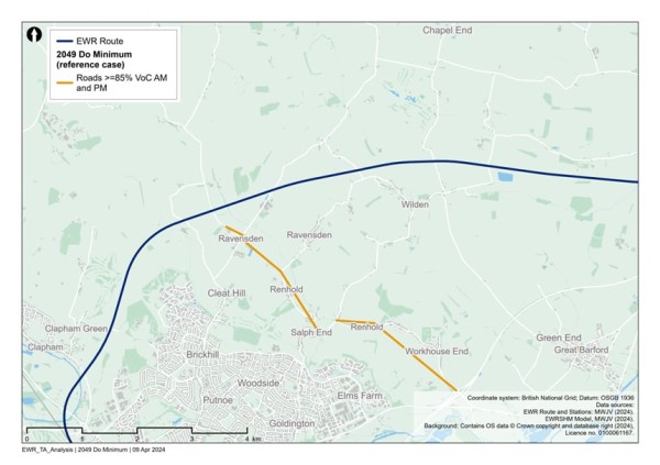
Figure 53, Figure 54 and Figure 55 show that between 2042 and 2049, the following roads operate close to or over capacity within this study area:
- Thurleigh Road, Oldways Road and Ravensden Road.
- Church End, Top End and Green End to the south near Renhold.
11.3 Project proposals
Between Clapham on the northern edge of Bedford and Colesden west of Wyboston, EWR requires entirely new railway and infrastructure. Along this 12km (7 mile) route section the railway would cross the rolling countryside north and east of Bedford using a mixture of new embankments, cuttings and short viaducts.
The proposed works are summarised as follows:
- New two-track railway with associated embankments, cuttings, viaducts and track infrastructure.
- New overbridges and underbridges for road, track and path crossings; culverts and overbridges for watercourses; and associated diversions where necessary.
- Two passing loops near Colesden so that faster passenger trains could overtake slower trains.
- Provision of drainage and water storage ponds (referred to as balancing ponds) to manage flood risk.
- Utility diversions along the route, including overhead electricity transmission lines.
The passenger train services proposed are:
- 2 x Oxford to Cambridge services in each direction per hour
- 1 x Stewartby to Cambridge service in each direction per hour
- 1 x Bedford to Cambridge service in each direction per hour
Construction compounds and movements
There are four main construction compounds proposed to support the works within this section. These temporary compounds would typically provide welfare, office and storage facilities and would be supported by several satellite compounds at strategic locations along the route.
The first main construction compound would be located at the interface with the proposed River Great Ouse viaduct. This compound would support delivery of the new viaduct and local earthworks.
The second main construction compound would be located in the centre of the Clapham Green to Colesden route section, adjacent to Sunderland Hill. This compound would support delivery of the work to the B660 and provide support to general earthworks.
The third main construction compound would be located off Chequers Hill to support construction of the new viaduct in the Wilden area.
The fourth main construction compound would be sited adjacent to Colesden Road, to support delivery of the passing loops.
Construction traffic routes to support the delivery of these works would be strictly controlled and the route to the nearest point of connection to the strategic road network (motorway and major A roads) would be assessed and defined to reduce the impact to the local area and stakeholders.
For compounds on the west side of this route section, construction traffic is expected to use the A6. The construction compounds close to Thurleigh Road and further to the east side of this route section would use either the A421 or the A1.
11.4 Potential impacts
A comparison has been undertaken between the 2032, 2034 and 2049 reference cases (no project) and the corresponding with project scenarios for those years, to determine what links become over capacity when project traffic is added to the network.
Figure 57 shows the links which become at or over capacity in 2032 because of construction traffic related to the project.
The roads identified include:
- Thurleigh Road/Butler Street/Mill Road north of Ravensden.
- Hookhams Lane at Salph End.
- Church End at Renhold.
Figure 56 - Comparison of 2032 reference case (no project) vs 2032 with project: additional roads with a Volume over Capacity >=85%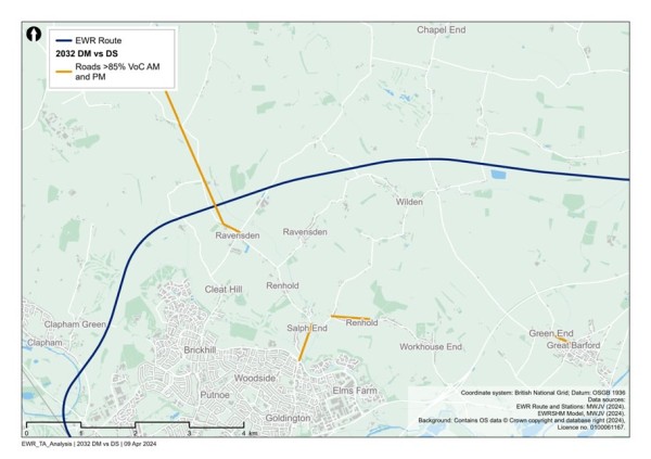
There are no additional roads with a VoC of greater than or equal to 85% in 2034 because of the project.
Figure 57 shows the additional roads with a VoC of greater than or equal to 85% in 2049 because of the project. The only link identified is Church End at Renhold.
Figure 57 - Comparison of 2049 reference case (no project) vs 2049 with project: additional roads with a Volume over Capacity >=85%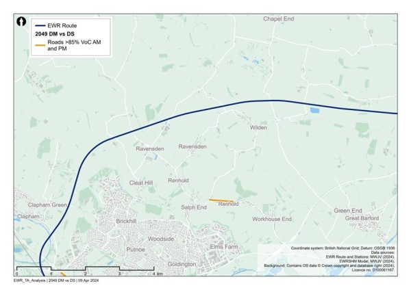
In addition to links which become over capacity in the ‘with project’ scenarios, there would be links that are already operating over capacity in the ‘no project’ scenarios, which are assessed to be pushed further over capacity in the ‘with project’ scenarios. These are not shown in the figures but would form part of further assessment in the TA and subsequent discussions with stakeholders regarding mitigation.
Based on the current design maturity, the following potential impacts in Table 25 are summarised within this study area section.
Table 25 - Clapham Green to Colesden potential impacts (transport)
|
Mode/Who |
Phase |
Change |
Potential impacts prior to mitigation |
|
Highway |
Construction |
A series of new highway under bridges and overbridges will be required at locations including: · Clapham Road. · Carriage Drive. · Graze Hill. · Thurleigh Road. · Sunderland Hill. · Shrubbery Lane. · Chequers Hill. · Colesden Road. |
Construction of the new railway alignment at these locations may require road closures in some cases, however temporary highway realignment will be constructed wherever possible. Vehicular access to properties will be maintained during construction. |
|
NMUs |
Construction |
Temporary construction works, including traffic management or changes to utility infrastructure required for the project, may affect NMU access and movement. |
In some places, existing level crossings, user worked crossings and footbridges or underpasses crossing the railway may be closed temporarily to allow construction to be safely carried out and this may result in diversions. Temporary traffic management may result in diversion routes or temporary closure of crossing points or footways. |
|
NMUs |
Construction |
Temporary traffic management may be required where the project affects the highway network. |
This may lead to delay on the highway network to pass through temporary traffic management measures, or use of diversion routes. The extents of these potential impacts have not yet been determined. The CTMP and CoCP will include provisions to reduce the impacts of these works on road users. |
|
Highway |
Construction |
Construction traffic movements on the network. |
Temporary traffic delay and/or congestion on the highway network, in particular routes which accommodate construction traffic. The CTMP and CoCP would include provisions to reduce the impacts of these works on road users. Interim modelling outputs provide initial information on potential locations of impact. |
|
NMUs |
Operation |
Existing PRoW routes which cross the proposed route alignment would require new crossing facilities or closure and associated diversions. |
This could lead to an increase in journey distance and journey time for NMUs. The suitability of diversion or alternative routes for all NMUs would be reviewed to ensure the proposed diversion routes are suitable, with mitigation proposed where required to enhance routes. |
|
Highway |
Operation |
Provision of new rail services would provide travel choice for longer distance trips supporting mode shift from car to rail. Additionally new or enhanced stations providing local access to rail services may also alter local trip patterns. |
Changes to highway demand due to mode shift from car to rail, or a change in local trip patterns with the opportunity to travel to (new) local stations to access enhanced or new rail services. This could result in some localised delay and congestion or see a reduction in traffic in some locations. |
12. Roxton to east of St Neots
12.1 Baseline area
The area runs along the proposed EWR alignment from South Brook west of Roxton to the roundabout between the B1428 Cambridge Road and the existing A428 to the east of St Neots. This alignment would serve a new station at Tempsford, with two alignment options for the railway in this area (Alignment 1b and Alignment 1c) being presented as part of this consultation. More information on the variations between the alignments is provided in the Technical Report. This section is situated within the local authority areas of Bedford Borough Council, Central Bedfordshire Council, Huntingdonshire District Council, South Cambridgeshire District Council and Cambridgeshire County Council.
Current baseline
Rail network
The East Coast Main Line (ECML) passes through the study area in this section with an existing station at St Neots (just outside the study area boundary) and crosses the alignment of EWR close to Tempsford.
The existing rail network in the section study area can be seen in Figure 58.
Figure 58 - Existing rail network in the Roxton to east of St Neots study area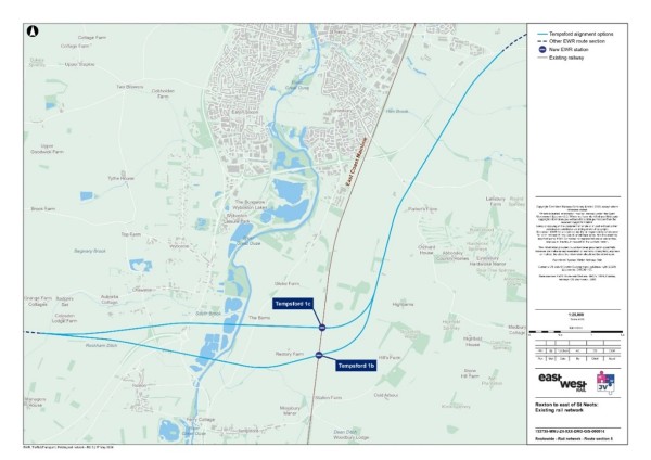
Table 26 summarises the existing level crossings along the route in this area.
Table 26 - Roxton to east of St Neots existing level crossings
|
Level Crossing Location |
Type |
Along EWR route? |
|
Love Lane Crossing |
Level crossing footpath. |
No - on ECML |
|
Tempsford (Station Road) |
Manually controlled barrier (locally monitored CCTV). |
No - on ECML |
A further level crossing of the ECML is further south, just outside of the study area boundary, on Tempsford Road (also a manually controlled barrier (with locally monitored CCTV).
Highway network
From north-south, the A1 bypasses St Neots and crosses the EWR alignment. The A428 and the existing and new A421 dual carriageway constructed as part of A428 Black Cat to Caxton Gibbet improvement scheme also cross the EWR alignment Option 1B within this area.
The baseline highway network can be seen in Figure 59.
Figure 59 - Baseline highway network for the Roxton to east of St Neots study area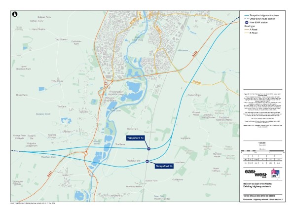
Traffic flows on motorways and major A roads in the study area (recorded as AADT by the DfT) are summarised in Table 27. The A1 carried just under 42,100 vehicles per day through the study area in 2023 in both directions combined and the A428 (south-east of St Neots) carried around 20,500 in 2023.
Table 27 - Annual Average Daily Traffic
|
Road name (location) |
Daily two-way traffic flow (2023) - vehicles |
|
A428 (south-east of St Neots) |
20,450 |
|
A421 |
35,823 (estimated) |
|
A1 (west of St Neots) |
42,072 |
Source: DfT - <Map Road traffic statistics - Road traffic statistics (dft.gov.uk)
A review of baseline traffic flows in the area using model data has revealed that there are several roads which are currently operating at close to or over capacity in the AM or PM. These are shown in Figure 60.
Figure 60 - 2023 Baseline routes operating at or over capacity within the Roxton to east of St Neots study area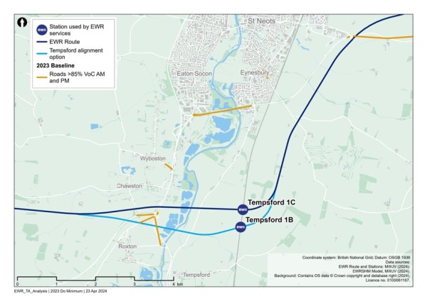
Road traffic collisions
To inform our understanding for the baseline, we have calculated the number of road traffic collisions that have occurred within the section study area, as well as the number which occur within an area that extends 100m (110 yards) from the draft Order Limits of EWR within Roxton to east of St Neots area. This information covers road traffic collisions for the five-year period between 2018 and 2022.
Within this area for Roxton to east of St Neots, there were four fatal, 53 serious and 154 slight road traffic collisions recorded. Within in the 100m (110 yards) buffer, there were no fatal, two serious and three slight road traffic collisions recorded[1].
Non-motorised users network
Figure 61 presents the existing PRoW network within the section study area.
Figure 61 - Roxton to east of St Neots public rights of way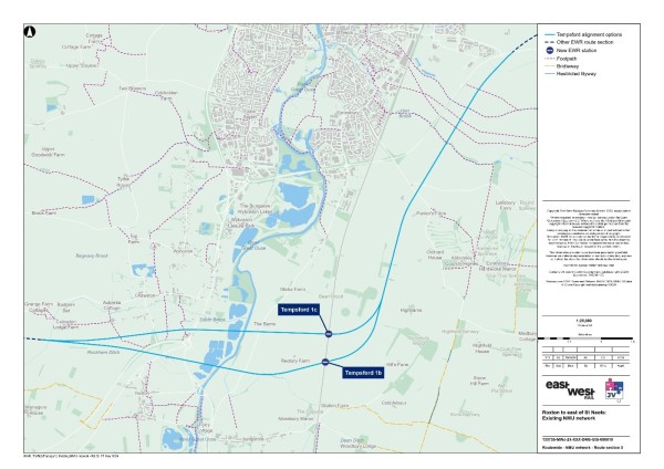
There are ten PRoWs within 250m (273 yards) of the EWR route, eight of which cross the Tempsford 1c EWR route and five cross the Tempsford 1c EWR route. The PRoW that cross the EWR railway line are listed in Table 28.
Table 28 - PRoW crossing the EWR railway line
|
PRoW number |
PRoW type |
|
A10 |
Footpath |
|
7 |
Footpath |
|
8 |
Footpath |
|
9 |
Footpath |
|
20 |
Footpath |
|
19 |
Footpath |
|
17 |
Footpath |
|
16 |
Footpath |
Source: OS Data.
Bus network
There are no existing EWR railway stations in the baseline area. However, a new EWR station is proposed at Tempsford. Table 29 details bus services in the vicinity of the proposed station location which could provide inter-change potential. Other services operate within the wider study area away from this vicinity.
Table 29 - Roxton to east of St Neots bus services
|
Service number |
Route |
Operator |
Frequency (per hour) |
EWR Station |
|
1A |
Biggleswade -Tempsford-Sandy - Langford - Biggleswade |
Ivel Sprinterx |
Twice per day (Tuesdays only). |
Station Road south of proposed EWR Tempsford station. |
|
1B |
Biggleswade -Tempsford-Sandy - Potton - Biggleswade |
Ivel Sprinterx |
Twice per day (Fridays only). |
Station Road south of proposed EWR Tempsford station. |
|
2 |
Biggleswade -Tempsford-Sandy - Potton - Cambridge |
Ivel Sprinterx |
Once per day (Wednesdays only). |
Station Road south of proposed EWR Tempsford station. |
|
4 |
Biggleswade -Tempsford-Sandy - Langford - Biggleswade |
Ivel Sprinterx |
Twice per day (Saturdays only). |
Station Road south of proposed EWR Tempsford station. |
|
5 |
Biggleswade -Tempsford-Sandy - Blunham-Great Barford -Bedford |
Ivel Sprinterx |
Once per day (3rd Mon of every month). |
Station Road south of proposed EWR Tempsford station. |
|
7 |
Biggleswade -Tempsford-Sandy - Langford - Biggleswade |
Ivel Sprinterx |
Once per day (1st Mon of every month). |
Station Road south of proposed EWR Tempsford station. |
|
112 |
Biggleswade -Tempsford-St Neots - Biggleswade |
Ivel Sprinterx |
Once per day (Thursdays only). |
Station Road south of proposed EWR Tempsford station. |
12.2 Future baseline
Future development and transport schemes
Changes to the transport networks will affect how they operate in the future. Additionally, changes to surrounding land use will change demand for use of these networks, meaning the future baseline situation could be dramatically different to the current 2023 baseline scenario, before the project is implemented. For all locations, this could include:
- Planning applications submitted and approved for new developments or Local Plan allocations coming forward.
- Upgrades and improvements to transport infrastructure (highway, active travel and public transport networks).
Specific to the Roxton to east of St Neots section, we have been made aware of the following schemes:
- The A428 extension: A new 10-mile dual carriageway being constructed by National Highways as part of A428 Black Cat to Caxton Gibbet improvement scheme (the A428 scheme). The new dual carriageway will be a continuation of the existing A421 and upon opening, National Highways will refer to the road as the A421. It will therefore be referred to as the new A421 dual carriageway within these documents. It is due to open in 2027.
Changes in traffic flow
Figure 62, Figure 63 and Figure 64 show the roads which are expected to operate at close to or over capacity without the project in the years 2032, 2034 and 2049.
Figure 62 - 2032 Volume over Capacity >=85% (without the project scenario)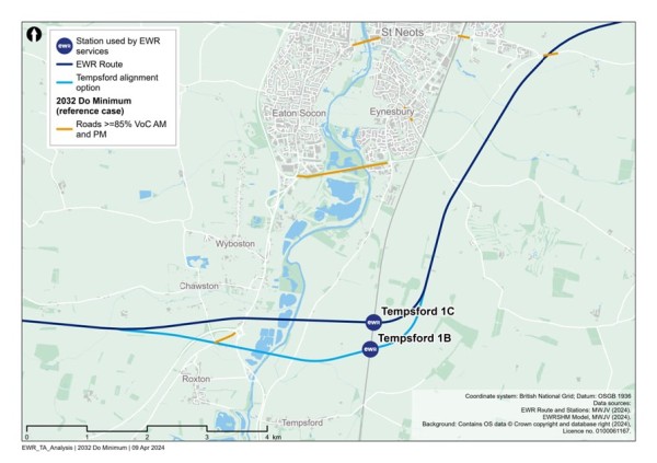
Figure 63 - 2034 Volume over Capacity >=85% (without the project scenario)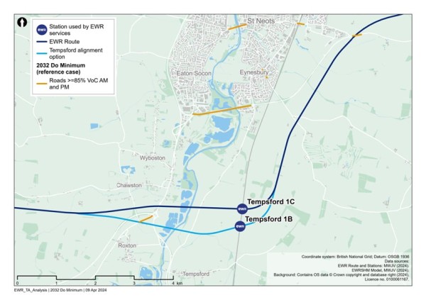
Figure 64 - 2049 Volume over Capacity >=85% (without the project scenario)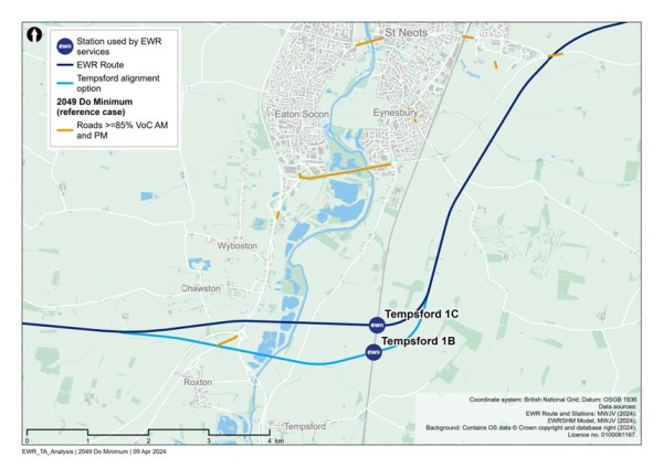
Figure 62, Figure 63 and Figure 64 show that between 2032 and 2049, there are a few additional roads that will operate at close to or over capacity including:
- A1 Great North Road, Southbound.
- A428 Cambridge Road.
- Adjacent to Wintringham Primary Academy.
12.3 Project proposals
This section of East West Rail comprises the construction of a new railway over approximately 10km (6.2 miles), between South Brook west of Roxton, and where the B1428 Cambridge Road joins the existing A428 at the roundabout east of St Neots. The proposed works are summarised as follows:
- New two-track railway and associated infrastructure, including two possible alignment options to cross the Great Ouse valley, each comprising long viaducts linked by embankment, as described separately in the following sections.
- A new station at Tempsford that would provide an interchange with the East Coast Main Line and serve existing communities and new communities within potential new developments south of St Neots and in the Tempsford area.
- Two options for a temporary logistics hub connecting with the proposed EWR alignment and the East Coast Main Line to be used to support construction, with land reinstated post-construction.
- New overbridges and underbridges to support the railway as it crosses roads, tracks and paths; culverts and overbridges for watercourses; and associated diversions where necessary.
- Provision of drainage and water storage ponds (referred to as balancing ponds) along the route section.
- Utility diversions along the route including overhead electricity transmission lines.
- The passenger train service pattern between Stewartby and Cambridge stations via Bedford would be two trains per hour in each direction.
This route section would interact with the new 10-mile dual carriageway that is (at the time of writing) being constructed by National Highways as part of A428 Black Cat to Caxton Gibbet improvement scheme. It is due to open in 2027. The new road is referred to here as the new A421, as this is how it will be named as part of the road network once constructed.
Construction compounds and movements
There would be two main construction compounds proposed to support construction of the viaducts, one to the east and one to the west. For Alignment 1b, compounds would also be needed to support the existing and new A421 dual carriageway crossings. There would also be several satellite compounds required along this section to manage delivery and provide local storage of materials and support facilities. The position and size would be dependent on the final alignment option.
Smaller compounds would also be provided north of Boys Wood including the temporary ECML rail logistics hub and main compounds to the east of the ECML and at Cambridge Road. The construction works and compounds would be predominantly located on farmland, crossing the flood plain of the Great Ouse River.
Construction traffic routes to support the delivery of these works would be strictly controlled and the route to the nearest point of connection to the strategic road network (motorway and major A roads) would be assessed and defined to reduce the impact to the local area and stakeholders.
For this section most of the construction traffic not using the rail logistics hub would utilise the A1 Great North Road and the A421. This is to be discussed further with National Highways. The use of the rail hub, with direct access for trains to and from the ECML will reduce HGV movements that might otherwise have used the local road network.
Construction impacts will be controlled by provisions within the CTMP and CoCP.
12.4 Potential impacts
A comparison has been undertaken between the 2032, 2034 and 2049 reference cases (no project) and the corresponding with project scenarios for those years, to determine what links become over capacity when project traffic is added to the network.
Figure 65 shows the links which become at, or over capacity in 2032 as a result of construction traffic related to the project. This scenario includes the new A421 dual carriageway. The roads identified include:
- Bedford Road and Roxton Road at Roxton.
- Chawston Lane at Chawston.
- The A428 at Eaton Socon.
- Link between A1 and A428 at Eaton Socon.
- The B1046 at Eynesbury.
- Barford Road at Eynesbury.
Figure 65 - Comparison of 2032 reference case (no project) vs 2032 with project: additional roads with a Volume over Capacity >=85%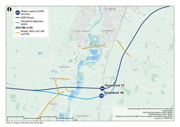
There are no additional roads with a VoC >=85% in the 2034 and 2049 reference case vs with project scenarios.
In addition to links which become over capacity in the ‘with project’ scenarios, there would be links that are already operating over capacity in the ‘no project’ scenarios, which are assessed to be pushed further over capacity in the ‘with project’ scenarios. These are not shown in the figures but would form part of further assessment in the TA and subsequent discussions with stakeholders regarding mitigation.
Based on the current design maturity, the following potential impacts in Table 30 are summarised within this study area section.
Table 30 - Roxton to east of St Neots potential impacts (transport)
|
Mode/Who |
Phase |
Change |
Potential impact prior to mitigation |
|
Highway |
Construction |
Depending upon the alignment option for this area, a series of new highway overbridges will be required at locations including at: The existing A421 and new A421 (SRN) Bedford Road to the north of Roxton The A1 Great North Road (SRN) The River Great Ouse Roxton Road |
Construction of new highway structures could cause delay to the strategic and local road networks. This will require temporary road and adjacent footway closures leading to journey delay and requiring use of temporary diversion routes. The suitability of temporary diversion or alternative routes for all users would be reviewed to ensure the proposed diversion routes are suitable, with mitigation proposed where required to enhance routes. |
|
NMU |
Operation |
Depending upon the alignment option for this area, a series of new footpath overbridges will be required to maintain PRoW connectivity. |
Construction of the new railway alignment at these locations will require diversion of footpaths. This could lead to an increase in journey distance and journey time for NMUs. The suitability of diversion or alternative routes for all NMUs would be reviewed to ensure the proposed diversion routes are suitable, with mitigation proposed where required to enhance routes. |
|
NMUs |
Construction |
Temporary construction works, including traffic management and changes to utility infrastructure required for the project, may affect NMU access and movement. |
In some places, footbridges or underpasses crossing the railway may be closed temporarily to allow construction to be safely carried out and this may result in diversions. Temporary traffic management may result in diversion routes or temporary closure of crossing points or footways. |
|
NMUs |
Construction |
Temporary traffic management may be required where the project affects the highway network. |
This may lead to delay on the highway network to pass through temporary traffic management measures, or use of diversion routes. The extents of these potential impacts have not yet been determined. The CTMP and CoCP will include provisions to reduce the impacts of these works on road users. |
|
Rail users |
Operation |
Revised travel patterns on the ECML in response to creation of new EWR station. |
This would lead to changes to times of journeys. |
|
NMUs |
Operation |
Existing PRoW routes which cross the proposed route alignment will require new crossing facilities or closure and associated diversions. |
Construction of the new railway alignment at these locations will require diversion of footpaths. This could lead to an increase in journey distance and journey time for NMUs. The suitability of diversion or alternative routes for all NMUs would be reviewed to ensure the proposed diversion routes are suitable, with mitigation proposed where required to enhance routes. |
|
Highway |
Operation |
Provision of new rail services would provide travel choice for longer distance trips supporting mode shift from car to rail. A new station at Tempsford providing local access to rail services may also alter local trip patterns, and cause changes to the local highway network associated with movements for access to/from the station car park. |
Changes to highway demand due to mode shift from car to rail, or a change in local trip patterns with the opportunity to travel to (new) local stations to access enhanced or new rail services. This could result in some localised delay and congestion or see a reduction in traffic in some locations. |
[1] STATS19, DfT, 2018-2022.
13. Croxton to Toft
13.1 Baseline area
The area runs along the proposed EWR alignment from the roundabout east of St Neots where the B1428 Cambridge Road joins the new A421 dual carriageway (constructed as part of the A428 Black Cat to Caxton Gibbet improvement scheme) to the B1046 between Toft and Comberton. This section of EWR is located within the Huntingdonshire and South Cambridgeshire local authority areas.
Current baseline
Rail network
There is no existing railway network or stations between Croxton and Toft along the EWR alignment.
Highway network
From north to south, the A1198 links Huntington and Royston and from west to east, the A428 runs to the north of Croxton and Toft.
The A428 crosses the EWR alignment at multiple locations within this area.
The baseline highway network can be seen in Figure 66.
Figure 66 - Baseline highway network for the Croxton to Toft study area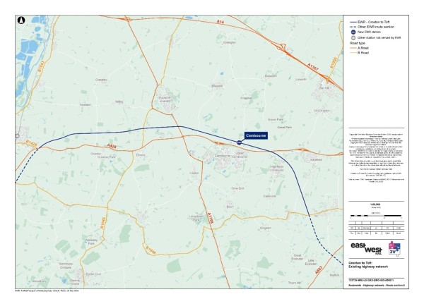
Traffic flows on motorways and major A roads in the study area (recorded as Annual Average Daily Traffic, AADT by the DfT) are summarised in Table 31. The A1198 carried just above 6,700 vehicles per day through the study area in 2023 in both directions combined and the A428 (south-east of St Neots) carried around 20,500 in 2023.
Table 31 - Annual Average Daily Traffic
|
Road name (location) |
Daily two-way traffic flow (2023) - vehicles |
|
A428 (south-east of St Neots) |
20,450 |
|
A1 (east of St Neots) |
42,072 |
|
A1198 (west of Cambourne Park) |
6,658 |
Source: DfT - Map Road traffic statistics - Road traffic statistics (dft.gov.uk).
A review of baseline traffic flows in the area using model data has revealed that there are several roads which are currently operating at close to or over capacity in the AM or PM. These are shown in Figure 67.
Figure 67 - 2023 Baseline routes operating at or over capacity within the Croxton to Toft study area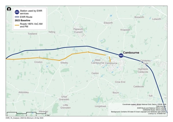
Road traffic collisions
To inform our understanding for the baseline, we have calculated the number of road traffic collisions that have occurred within the section study area, as well as the number which occur within an area which extends 100m (110 yards) from the draft Order Limits of EWR within Croxton to Toft area. This information covers road traffic collisions for the five-year period between 2018 and 2022.
Within this area for Croxton to Toft, there was one fatal, 58 serious, and 125 slight road traffic collisions recorded. Within the 100m (110 yards) buffer, there were no road traffic collisions recorded[1].
Non-motorised users network
Figure 68 presents the existing PRoW network within the section study area.
Figure 68 - Croxton to Toft public rights of way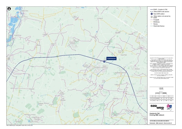
There are 12 PRoWs within 250m (273 yards) of the EWR route, of which ten cross the railway line itself. The PRoW that cross the EWR railway line are listed in Table 32.
There are four PRoWs located close to where the new Cambourne station is proposed.
Table 32 - PRoW crossing the EWR railway line
|
PRoW number |
PRoW type |
|
18 |
Bridleway |
|
7 |
Footpath |
|
3 |
Bridleway |
|
4 |
Bridleway |
|
5 |
Footpath |
|
8 |
Footpath |
|
7 |
Byway |
|
1 |
Footpath |
|
9 |
Footpath |
|
5 |
Bridleway |
Source: OS Data.
Bus Network
The bus services that serve Cambourne and will therefore run close to the new Cambourne station are listed in Table 33.
Table 33 - Croxton to Toft bus services
|
Service number |
Route |
Operator |
Frequency (per hour) |
EWR Station |
|
4 |
Cambourne - Cambridge |
Stagecoach |
2 |
Cambourne |
|
4A |
Cambourne - Cambridge |
Stagecoach |
1 per day |
Cambourne |
|
X2 |
Cambridge to Huntingdon |
Whippet |
Twice a day |
Cambourne |
|
X3 |
Addenbrooke's to Huntingdon |
Whippet |
1 |
Cambourne |
|
18 |
Cambridge - St Neots |
Whippet |
1 |
Cambourne |
13.2 Future baseline
Future development and transport schemes
Changes to the transport networks would affect how they operate in the future. Additionally, changes to surrounding land use will change demand for use of these networks, meaning the future baseline situation could be dramatically different to the current 2023 baseline scenario, before the project is implemented. For all locations, this could include:
- Planning applications submitted and approved for new developments or Local Plan allocations coming forward.
- Upgrades and improvements to transport infrastructure (highway, active travel and public transport networks).
Specific to the Croxton to Toft section, we have been made aware of the following schemes:
- The A428 extension: A new 10-mile dual carriageway being constructed by National Highways as part of A428 Black Cat to Caxton Gibbet improvement scheme (the A428 scheme). The new dual carriageway will be a continuation of the existing A421 and upon opening, National Highways will refer to the road as the new A421 dual carriageway. It will therefore be referred to as the new A421 dual carriageway within these documents. It is due to open in 2027.
- Currently being developed - Land to the West of Cambourne: Development of up to 2,350 residential units including affordable housing retail use classes A1A5 (up to 1.04 hectares) offices/light industry use class B1 (up to 6.25 hectares) community and leisure facilities use class D1 and D2 (up to 0.92 hectares).
- Cambourne Village College (S/0457/14/CC/C1) - Additionally, this would include two primary schools and one secondary school (up to 11 hectares) use class D1 three vehicular access points including the extension and modification of Sheepfold Lane a four arm roundabout provided on the A1198/Caxton Bypass and an access point off the A1198 south of the Caxton Gibbet to serve the proposed employment uses a network of segregated pedestrian and cycle routes sustainable drainage system and other infrastructure together with associated earth works parking open space including equipped play playing fields and landscaping.
- S/3440/18/OL - Bourn (Bourn Airfield) - Outline planning permission for a proposed new mixed-use village comprising residential development of approximately 3,500 dwellings and a variety of commercial uses, and associated landscaping and access changes.
Changes in traffic flow
Figure 69, Figure 70 and Figure 71 show the roads which are expected to operate at close to or over capacity without the project in the years 2032, 2034 and 2049. These scenarios include the under development new A421 dual carriageway.
Figure 69 - 2032 Volume over Capacity >=85% (without the project scenario)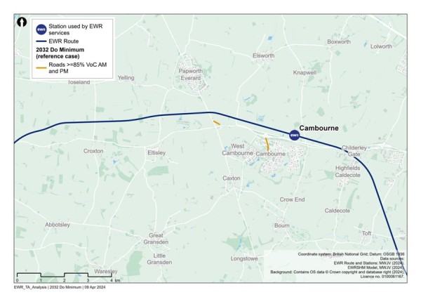
Figure 70 - 2034 Volume over Capacity >=85% (without the project scenario)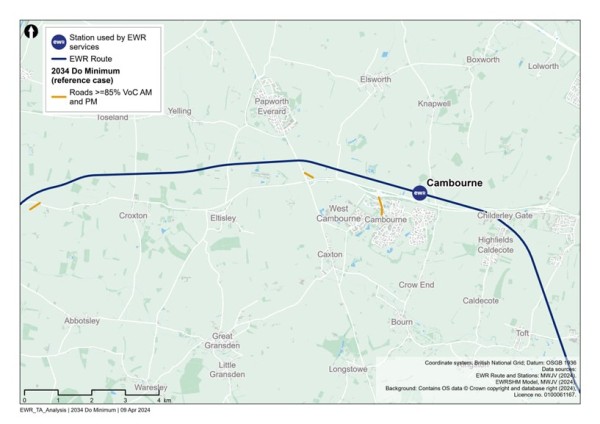
Figure 71 - 2049 Volume over Capacity >=85% (without the project scenario)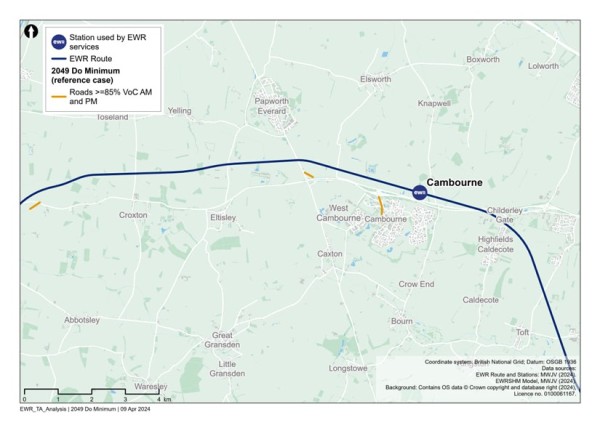
Figure 69, Figure 70 and Figure 71 show that between 2032 and 2049, a small additional section of the A428 Cambridge Road to the west of the study area would operate at close to or over capacity as well as Cambourne Road and Broad Street through Cambourne.
13.3 Project proposals
This 19km (12 miles) route section includes a new railway beginning at the roundabout east of St Neots, running north of Cambourne and the proposed A421 and A428, before crossing the A428 and ending at the B1046 between Toft and Comberton.
The proposed works are summarised as follows:
- New two-track track railway and associated infrastructure.
- Passing loops between Brockley Road and Cambourne.
- New station at Cambourne.
- New cut and cover tunnel beneath the A428, the proposed Bourn Airfield development and Highfields Caldecote, with associated temporary diversions of the A428 and other local roads.
- New overbridges and underbridges for road, track and path crossings; bridges and culverts for watercourses; and associated diversions where necessary.
- Construction of various drainage and water storage ponds (referred to as balancing ponds) along the route section.
- Utility diversions along the route including overhead electricity transmission lines.
The passenger train services proposed are:
- 2 x Oxford to Cambridge services in each direction per hour
- 1 x Stewartby to Cambridge service in each direction per hour
- 1 x Bedford to Cambridge service in each direction per hour
With provision for up to two freight trains per day in each direction.
Construction compounds and movements
Two main compounds would support the works within this section, one located immediately east of Cambridge Road junction, and the other both sides of Toseland Road.
Construction traffic routes to support the delivery of these works would be strictly controlled and the route to the nearest point of connection to the strategic road network (motorway and major A roads) would be assessed and defined to reduce the impact to the local area and stakeholders.
Construction HGV movements in this section would generally utilise the new A421 dual carriageway and existing A428 which runs south of and parallel to the proposed railway in this section and provides good connectivity to both the A1 and M11.
13.4 Potential impact
A comparison has been undertaken between the 2032, 2034 and 2049 reference cases (no project) and the corresponding (with project) scenarios for those years, to determine what links become over capacity when project traffic is added to the network.
Figure 72 shows the links which become at or over capacity in 2032 as a result of construction traffic related to the project. This scenario includes the proposed A421 scheme.
The roads identified include:
- Road link at Wintringham.
- The B1040 at Eltisley and Papworth Everard.
- High Street at Yelling.
- St Neots Road at Elsworth.
- School Lane at Cambourne.
Figure 72 - Comparison of 2032 reference case (no project) vs 2032 with project: additional roads with a Volume over Capacity >=85%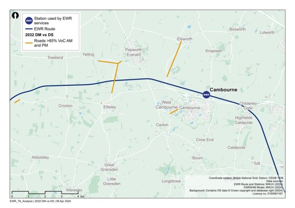
There are no additional roads with a VoC greater than or equal to 85% in the 2034 and 2049 reference case vs with project scenarios.
In addition to links which become over capacity in the ‘with project’ scenarios, there would be links that are already operating over capacity in the ‘no project’ scenarios, which are assessed to be pushed further over capacity in the ‘with project’ scenarios. These are not shown in the figures but would form part of further assessment in the TA and subsequent discussions with stakeholders regarding mitigation.
Based on the current design maturity, the following potential impacts in Table 34 are summarised within this study area section.
Table 34 - Crofton to Toft potential impacts (transport)
|
Mode/Who |
Phase |
Change |
Potential impact prior to mitigation |
|
Highway |
Construction |
New highway overbridges at Toseland Road, Saint Ives Road (B1040), Ermine Street South (A1198), Brockley Road/St Neots Road, Knapwell Wood Road, and Hardwick Road. A cut and cover rail tunnel beneath St Neots Road, A428, Highfields Road and Wellington Way. |
Construction of the overbridges is planned to be undertaken with temporary realignment or offline construction, largely requiring only off-peak temporary traffic management. Construction of the cut and cover rail tunnel would require temporary realignment of the roads above this will largely require only off-peak temporary traffic management. |
|
NMUs |
Construction |
Temporary construction works, including traffic management or changes to utility infrastructure required for the project, and may affect NMU access and movement. |
In some places, existing footbridges or underpasses crossing the railway may be closed temporarily to allow construction to be safely carried out and this may result in diversions. Temporary traffic management may result in diversion routes or temporary closure of crossing points or footways. |
|
NMUs |
Construction |
Temporary traffic management may be required where the project affects the highway network. |
This may lead to delay on the highway network to pass through temporary traffic management measures, or use of diversion routes. The extents of these potential impacts have not yet been determined. The CTMP and CoCP will include provisions to reduce the impacts of these works on road users. |
|
Highway |
Construction |
Construction traffic movements on the network. |
Temporary traffic delay and/or congestion on the highway network, in particular routes which accommodate construction traffic. The CTMP and CoCP will include provisions to reduce the impacts of these works on road users. Interim modelling outputs provide initial information on potential locations of impact. |
|
Rail users |
Operation |
New train frequency on the line and revised travel patterns in response to creation of new EWR stations. |
Improved access to and journey times for rail trips with a mode shift from car to rail due to new station facilities. |
|
NMUs |
Operation |
Existing PRoW which cross the proposed route alignment will require new crossing facilities or closure and associated diversions. |
This could lead to an increase in journey distance and journey time for NMUs. The suitability of diversion or alternative routes for all NMUs will be reviewed to ensure the proposed diversion routes are suitable, with mitigation proposed where required to enhance routes. |
|
Highway |
Operation |
Provision of new rail services will provide travel choice for longer distance trips supporting mode shift from car to rail. Additionally new or enhanced stations providing local access to rail services may also alter local trip patterns. |
Changes to highway demand due to mode shift from car to rail, or a change in local trip patterns with the opportunity to travel to (new) local stations to access enhanced or new rail services. This could result in some localised delay and congestion or see a reduction in traffic in some locations. Options for mitigation to provide additional capacity at locations will be reviewed and discussed with key stakeholders. |
[1] STATS19, DfT, 2018-2022.
14. Comberton to Shelford
14.1 Baseline area
This section would run along the proposed EWR railway between the B1046 Comberton Road and Addenbrooke’s Road, Shelford crossing the A10 and M11. This section of EWR is located entirely within the South Cambridgeshire Local Authority area.
Current baseline
Rail network
There are two existing rail lines which pass through this section of the study area.
The Shepreth Branch Line links Thameslink services between Cambridge and London King’s Cross. There are two existing stations for this line within the study area - Foxton and Shepreth, however these are not EWR stations.
The West Anglia Main Line (WAML) passes through the study area in this section with an existing station at Shelford. This station is served by Great Anglia with services between Cambridge and London Liverpool Street. Shelford is not an EWR station.
The existing rail network in the section study area can be seen in Figure 73.
Figure 73 - Existing rail network in the Comberton to Shelford study area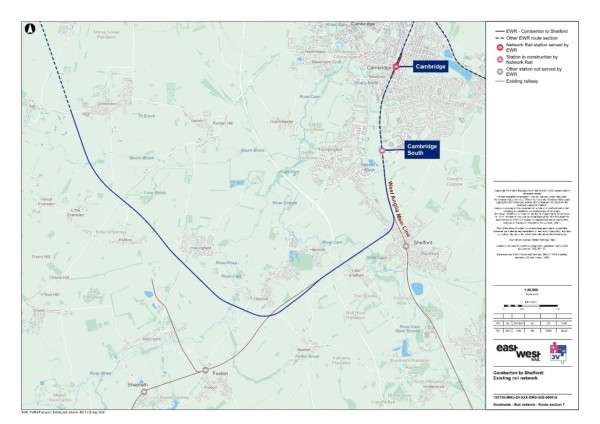
Table 35 summarises the existing stations near to the EWR route and their facilities and destinations.
Table 35 - Comberton to Shelford existing railway stations
|
Station |
EWR service |
Facilities |
Destinations |
|
Shepreth |
No |
Waiting room. Bicycle stands. |
London Kings Cross. Cambridge. |
|
Foxton |
No |
Waiting room. Bicycle stands. |
London Kings Cross. Cambridge. |
|
Shelford |
No |
Ticket office. Waiting room. Bicycle storage. |
London Liverpool Street. Cambridge North. |
Source: National Rail.
Table 36 summarises the existing demand at Shepreth, Foxton and Shelford stations through station entries and exits. At Shelford station there were over 170,000 station entries and exits between April 2022 and March 2023.
Table 36 - Comberton to Shelford station entries and exists
|
Station |
Entries and exits (April 2022 to March 2023) |
|
Shepreth |
91,082 |
|
Foxton |
87,794 |
|
Shelford |
170,262 |
Source: ORR - Table 1410.
Table 37 summarises the existing level crossings in this area, with not all of these being along the EWR route.
Table 37 - Comberton to Shelford existing level crossings
|
Level Crossing Location |
Type |
Along the EWR route |
|
Station Road, Shepreth |
Public highway automatic half barriers |
No |
|
Angle Lane (PRoW 200/6) |
Private user worked crossing with telephone |
No |
|
A10 Cambridge Road (Foxton station) |
Public highway automatic half barriers |
No |
|
Harston (Newton Road/Station Road) |
Public highway automatic half barriers |
Yes |
|
Hayes (PRoW 116/4) |
Private User worked crossing with telephone |
Yes |
|
Hauxton Road |
Public highway automatic half barriers |
Yes |
|
Rectory Road |
Private user worked crossing with telephone |
Yes |
|
Manor Farm |
Private user worked crossing with telephone |
Yes |
|
Websters (PRoW 198/1) |
Private user worked crossing with telephone |
Yes |
|
Dukes No 2 |
Private user worked crossing with telephone. |
Yes |
Highway network
The key north-south roads through the area, which would cross the alignment of EWR include the M11 and A10. The key east-west road is the A603 which connects Cambridge with the M11 at Junction 12 and continues south-west. The baseline highway network can be seen in Figure 74.
Figure 74 - Baseline highway network for the Comberton to Shelford study area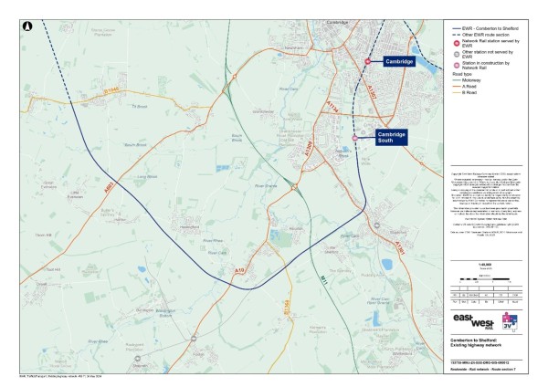
Traffic flows on motorways and Major A roads in the study area (recorded as Average Annual Daily Traffic (AADT) by the DfT) are summarised in Table 38. The M11 carried around 88,200 vehicles per day through the study area in 2023 in both directions combined. The A603 carried nearly 9,100 vehicles per day in 2023.
Table 38 - Annual Average Daily Traffic (AADT)
|
Road name (location) |
Daily two-way traffic flow (2023) - vehicles |
|
M11 (south of Bin Brook - west Cambridge) |
88,177 |
|
A10 (south-west of Cambridge) |
10,943 (estimated) |
|
A603 (south-west of Cambridge) |
9,096 (estimated) |
Source: DfT – Map Road traffic statistics – Road traffic statistics (dft.gov.uk)
A review of baseline traffic flows in the area using model data has revealed that there are several roads which are currently operating at close to or over capacity in the AM or PM. These are shown in Figure 75.
Figure 75 - 2023 Baseline routes operating at or over capacity within the Comberton to Shelford study area
Road traffic collisions
To inform our understanding for the baseline, we have calculated the number of road traffic collisions that have occurred within the section study area, as well as the number which occur within an area which extends approximately 100m (110 yards) from the draft Order Limits of EWR within the Comberton to Shelford area. This information covers road traffic collisions for the five-year period between 2018 and 2022.
Within this area for Comberton to Shelford, there were three fatal, 36 serious and 93 slight road traffic collisions recorded. Within 100m (110 yards) from the draft Order Limits for this section, there were no fatal, no serious and one slight road casualty recorded[1].
Non-motorised users network
Figure 76 presents the existing public rights of way network within the section study area.
Figure 76 - Comberton to Shelford public rights of way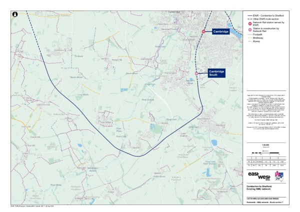
There are 12 PRoWs within 250m (275 yards) of the EWR route, of which five cross the railway itself. The PRoWs that cross the EWR railway line are listed in Table 39.
Table 39 - PRoW crossing the EWR railway line
|
PRoW number |
PRoW type |
|
16 |
Footpath |
|
26 |
Footpath |
|
13 |
Footpath |
|
4 |
Footpath |
|
1 |
Footpath |
Source: OS Data.
Bus network
Due to there being no existing stations that would be EWR stations within this section, there are no bus services included within this baseline.
Bus services that would serve new stations and that may be affected by level crossing closures would be assessed when more detail is available about their locations.
14.2 Future baseline
Future development and transport schemes
Changes to the transport networks would affect how they operate in the future. Additionally, changes to surrounding land use would change demand for use of these networks, meaning the future baseline situation could be dramatically different to the current 2023 baseline scenario, before the project is implemented. For all locations, this could include:
- Planning applications submitted and approved for new developments or Local Plan allocations coming forward.
- Upgrades and improvements to transport infrastructure (highway, active travel and public transport networks).
Changes in traffic flow
Figure 77, Figure 78 and Figure 79 show the roads which are expected to operate at close to or over capacity without the project in the years 2032, 2034 and 2049.
Figure 77 - 2032 Volume over Capacity >=85% (without the project scenario)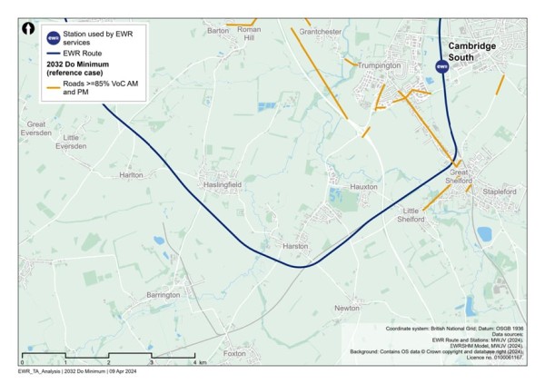
Figure 78 - 2034 Volume over Capacity >=85% (without the project scenario)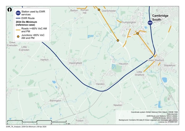
Figure 79 - 2049 Volume over Capacity >=85% (without the project scenario)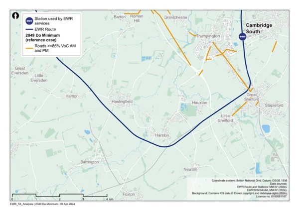
Figure 77, Figure 78 and Figure 79 show that between 2032 and 2049, there are a few additional roads that would operate at close to or over capacity including the M11 Junction 11 southbound off slip, the M11 Junction 12 and along Shelford Road with the junction of Hauxton Road.
14.3 Project proposals
This 14.3km (8.9 mile) section of the route extends between the B1046 Comberton Road to Addenbrooke’s Road, Shelford. EWR would require new rail infrastructure along much of its route but would use an existing section of railway from a proposed grade separated junction (called Hauxton junction), where it joins the existing Shepreth Branch Royston Line (SBR) that serves trains between Cambridge and London King’s Cross.
North of Great Shelford, East West Rail would reconfigure the existing Shepreth Branch junction that connects to the West Anglia Main Line (WAML) that serves trains between Cambridge and London Liverpool Street. Two new tracks would be introduced alongside the existing two-track WAML corridor through the new Cambridge South station (which is under construction at time of writing) and into Cambridge station, although some of this will have been introduced as part of the Cambridge South works.
The proposed works are summarised as follows:
- New two-track railway with associated infrastructure between Comberton and Hauxton junction east of the A10 Royston Road.
- Various watercourse culverts, as well as two viaducts over Bourn Brook to the south of Comberton, and the Rhee/Cam to the west of Harston.
- Tunnel beneath Chapel Hill, south of Haslingfield.
- Realignment of the SBR south of Harston and creation of the new Hauxton junction west of the M11, where EWR joins the existing SBR.
- Realignment of the A10 onto a bridge over the new East West Rail line.
- Closure of two level crossings at Harston and Hauxton with road diversions introduced via new bridge crossings; closure of a footpath level crossing at Harston; and closure of a farm track level crossing at Great Shelford.
- Provision of passing loops at Hauxton junction to allow fast trains to overtake slower trains.
- Provision of various drainage and water storage ponds (referred to as balancing ponds) along the route section.
- New overbridges and underbridges for road, track and path crossings, as well as diversions and realignments.
- Modifications to existing roads and introduction of new maintenance access roads.
The passenger train services proposed are:
- 2 x Oxford to Cambridge services in each direction per hour
- 1 x Stewartby to Cambridge service in each direction per hour
- 1 x Bedford to Cambridge service in each direction per hour
This is in addition to the non-East West Rail services that run on the SBR and the WAML including both passenger and freight services.
Construction compounds and movements
There would be two main compounds in this area to support construction of structures, highway realignments, accesses and to form the earthworks for the railway. These would be located immediately south of Comberton, and adjacent to the road realignments of Comberton Road (B1046) and Cambridge Road (A603). Construction traffic routes to support the delivery of these works would be strictly controlled and the route to the nearest point of connection to the strategic road network (motorway and major A roads) would be assessed and defined to reduce the impact to the local area and stakeholders.
The majority of construction traffic within this section would utilise the A10 and A603 and provide direct access to the M11.
14.4 Potential impacts
A comparison has been undertaken between the 2032, 2034 and 2049 reference cases (no project) and the corresponding with project scenarios for those years, to determine what links become over capacity when project traffic is added to the network. Figure 80 shows the links which become at or over capacity in 2032 because of construction traffic related to the project.
The roads identified include:
- Barton Road at Haslingfield.
- The A10 at Hauxton.
- Road links in Cambridge close to the M11 Junction 11.
- Shelford Road at Little Shelford.
Figure 80 - Comparison of 2032 reference case (no project) vs 2032 with project: additional roads with a Volume over Capacity >=85%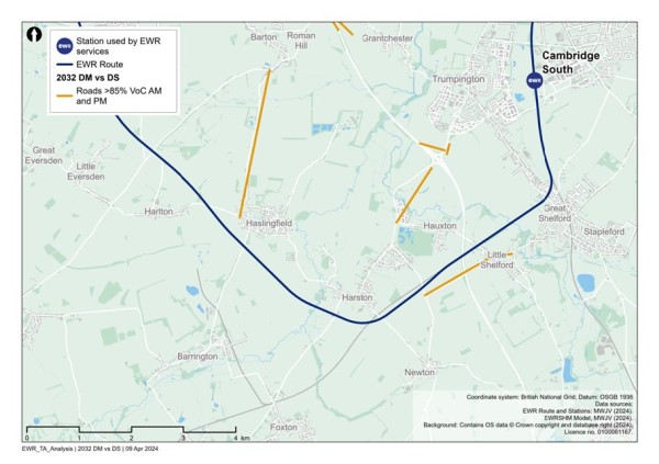
Figure 81 shows the additional roads with a VoC of greater than or equal to 85% in 2034 because of the project. The links include:
- The A10 at Harston.
- Road links in Cambridge close to the M11 Junction 11.
- Shelford Road at Little Shelford.
Figure 81 - Comparison of 2034 reference case (no project) vs 2034 with project: additional roads with a Volume over Capacity >=85%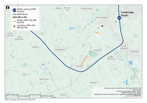
Figure 82 shows the additional roads with a VoC of greater than or equal to 85% in 2049 because of the project. The links include:
- The A10 at Harston.
- Shelford Road at Little Shelford.
Figure 82 - Comparison of 2049 reference case (no project) vs 2049 with project: additional roads with a Volume over Capacity >=85%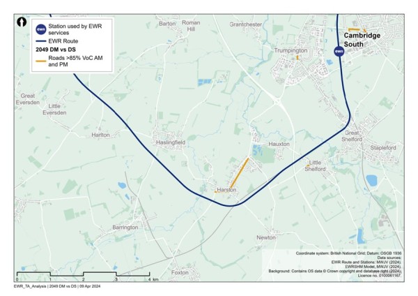
- In addition to links which become over capacity in the ‘with project’ scenarios, there would be links that are already operating over capacity in the ‘no project’ scenarios, which are assessed to be pushed further over capacity in the ‘with project’ scenarios. These are not shown in the figures but would form part of further assessment in the TA and subsequent discussions with stakeholders regarding mitigation.
- Based on the current design maturity, the following potential impacts in Table 40 are summarised within this study area section.
Table 40 - Comberton to Shelford potential impacts (transport)
|
Mode/Who |
Phase |
Change |
Potential impact prior to mitigation |
|
Highway |
Construction |
New highway overbridges at Comberton Road, (B1040), Harlton Road, A10 Royston Road, London Road and Newton Road. New highway underbridges at Cambridge Road. Shelford Road. A rail tunnel beneath Chapel Hill Road. Highway junction realignments at Comberton Road and Washpit Lane. Replacement of level crossing at Hauxton Road by an offline overbridge. |
Construction of the highway bridges is planned to be undertaken with temporary realignment or offline construction, largely requiring only off-peak temporary traffic management, including nighttime or weekend closures in some cases. It is expected that the Hauxton Road level crossing would remain open until the replacement overbridge is open to traffic. |
|
NMUs |
Construction |
Construction works, including temporary traffic management and changes to utility infrastructure required for the project, may affect NMU access and movement. |
In some places, existing level crossings, user worked crossings and footbridges or underpasses crossing the railway may be closed temporarily to allow construction to be safely carried out and this may result in diversions. Temporary traffic management may result in diversion routes or temporary closure of crossing points or footways. |
|
Highway |
Construction |
Temporary traffic management may be required where the project affects the highway network. |
This may lead to delay on the highway network to pass through temporary traffic management measures, or use of diversion routes. The extents of these potential impacts have not yet been determined. The CTMP and CoCP would include provisions to reduce the impacts of these works on road users. |
|
Rail users |
Construction |
Some construction activities may require temporary suspension of rail services. |
Alternative transport would be provided where possible, in consultation with train operating companies and other affected stakeholders. |
|
Highway |
Construction |
Construction traffic movements on the network. |
Temporary traffic delay and/or congestion on the highway network, in particular routes which accommodate construction traffic. The CTMP and CoCP would include provisions to reduce the impacts of these works on road users. Interim modelling outputs provide initial information on potential locations of impact. |
|
NMUs |
Operation |
Existing PRoW routes which cross the proposed route alignment would require new crossing facilities or closure and associated diversions. |
This could lead to an increase in journey distance and journey time for NMUs. The suitability of diversion or alternative routes for all NMUs would be reviewed to ensure the proposed diversion routes are suitable, with mitigation proposed where required to enhance routes. |
|
Highway |
Operation |
Provision of new rail services would provide travel choice for longer distance trips supporting mode shift from car to rail. Additionally new or enhanced stations providing local access to rail services may also alter local trip patterns. |
Changes to highway demand due to mode shift from car to rail, or a change in local trip patterns with the opportunity to travel to (new) local stations to access enhanced or new rail services. This could result in some localised delay and congestion or see a reduction in traffic in some locations. Options for mitigation to provide additional capacity at locations will be reviewed and discussed with key stakeholders. |
[1] STATS19, DfT, 2018-2022.
15. Cambridge
15.1 Baseline area
Current baseline
This section of the route area runs along the proposed EWR railway from Shelford to the south, northwards through the urban area of Cambridge. This section of EWR is located entirely within the South Cambridgeshire and Cambridge Local Authority areas in Cambridgeshire.
Rail network
Cambridge is a stop on both the WAML (providing a connection to London Liverpool Street via Bishop’s Stortford) and the Cambridge Line which provides a link, via Royston, to the ECML at Hitchin, into London King’s Cross. Trains on the WAML are operated by Greater Anglia and trains on the Cambridge line are operated by Greater Northern (King’s Lynn to King’s Cross) and Thameslink (Cambridge to Brighton via St Pancras). CrossCountry services between Birmingham New Street and Stansted Airport, and Greater Anglia services to Ipswich, Stansted Airport, and Norwich all call at the station.
The existing rail network in the section study area can be seen in Figure 83.
Figure 83 - Existing rail network in the Cambridge study area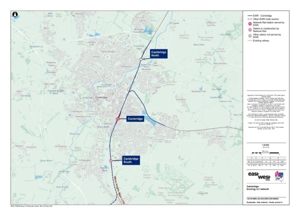
Table 41 summarises the existing stations along the EWR route alignment and their facilities and destinations.
Table 41 - Cambridge existing railway stations
|
Station |
EWR service |
Facilities |
Destinations |
|
Cambridge |
Yes |
· Ticket office · Toilets · Waiting room · Car park (374 spaces) · Bicycle storage |
· Kings Lynn · London Kings Cross · Norwich · Ely · London Liverpool Street · Brighton · Cambridge North · Ipswich · Stansted Airport |
|
Cambridge North |
No |
· Toilets · Waiting room · Car park (450 spaces) · Bicycle spaces |
· Kings Lynn · London Kings Cross · Norwich · Ely · London Liverpool Street · Stansted Airport |
Source: National Rail.
Table 42 summarises the existing demand at Cambridge station through station entries and exits. There were nearly 9,350,000 station entries and exits between April 2022 and March 2023.
Table 42 - Cambridge entries and exits
|
Station |
Entries and exits (April 2022 to March 2023) |
|
Cambridge |
9,341,600 |
Source: ORR - Table 1410.
Table 43 summarises the existing level crossings along the route in this area.
Table 43 - Cambridge existing level crossings
|
Level Crossing Location |
Type |
Along EWR route? |
|
Chesterton Junction (Fen Road) |
Public highway manually controlled barriers (locally monitored by CCTV) (locally monitored by CCTV). |
Yes |
|
Laundry Lane * |
Private automatic half barrier crossing. |
Yes |
|
Hospital |
Private user worked crossing with telephone. |
Yes |
|
Dukes Pemberton No 3 |
Private user worked crossing with telephone. |
Yes |
|
Pinks |
User worked crossing. |
No |
|
Cherry Hinton |
Manually controlled barrier (locally monitored CCTV). |
No |
Highway network
The key north-south roads through the area, which would cross the route of EWR include the M11, which bypasses Cambridge and merges with the A14 to the north-west. The A11 provides north-east and south-west connectivity off to the east of Cambridge between the M1, A505 and A14.
The key east-west route crossed by the EWR railway is the A10, to the west of Harston, where the alignment of the EWR heads north-west. The A14 runs to the north of Cambridge eastwards from the M1/A428 towards the A11 in the east.
The baseline highway network can be seen in Figure 84.
Figure 84 - Baseline highway network for the Cambridge study area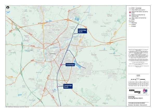
Traffic flows on motorways and major A roads in the study area (recorded as AADT by the DfT) are summarised in Table 44. The A1134 Elizabeth Way carried 26,200 vehicles per day through the study area in 2023 in both directions combined and the A603 carried nearly 11,800 vehicles per day.
Table 44 - Annual Average Daily Traffic
|
Road name (location) |
Daily two-way traffic flow (2023) - vehicles |
|
A1037 Hills Road |
9,334 |
|
A1134 High Street |
9,847 (estimated) |
|
A1134 Newmarket Road |
16,523 (estimated) |
|
A1134 Elizabeth Way |
26,225 (estimated) |
|
A603 East Road |
11,811 (estimated) |
|
A1309 Milton Road |
11,432 (estimated) |
|
A1134 The Fen Causeway |
19,919 (estimated) |
Source: DfT - Map Road traffic statistics – Road traffic statistics (dft.gov.uk)
A review of baseline traffic flows in the area has revealed that there are several roads which are currently operating at close to or over capacity in the AM or PM. These are shown in Figure 85.
Figure 85 - 2023 Baseline routes operating at or over capacity within the Cambridge study area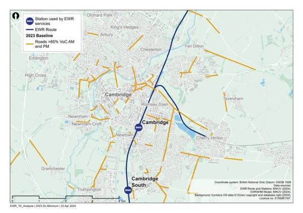
Road traffic collisions
To inform our understanding for the baseline, we have calculated the number of road traffic collisions that have occurred within the section study area, as well as the number which occur within an area which extends approximately 100m (110 yards) from the draft Order Limits of EWR within Cambridge has been specified, and road traffic collisions for the five-year period between 2018 and 2022 identified.
Within this area for Cambridge, there were five fatal, 315 serious and 1,022 slight road traffic collisions recorded. Within 100m (110 yards) from the draft Order Limits for this section there was one fatal, ten serious and 31 slight road traffic collisions recorded[1].
Non-motorised users network
At Cambridge station, there are restrictions of vehicular access on roads immediately surrounding the station (including the busway) excluding cyclists, meaning that there is more limited interaction between cycles and vehicles close to the station (though buses still mix with cycles). There is a painted cycle lane on the A1307 Hills Road which leads south away from the city centre. The provision on this road towards the city centre is limited beyond the immediate station area. Pedestrian access to the station is from Station Square to the west of the railway. There is a large area of public realm to the front of the station and restrictions on vehicle access provide an enhanced environment for pedestrians. A ramped pedestrian and cycle bridge provides access to the station from the east side of the railway. This bridge crosses the railway to the north of the station connecting Rustat Road to Devonshire Road.
Figure 86 presents the existing PRoW network within the section study area.
Figure 86 - Cambridge public rights of way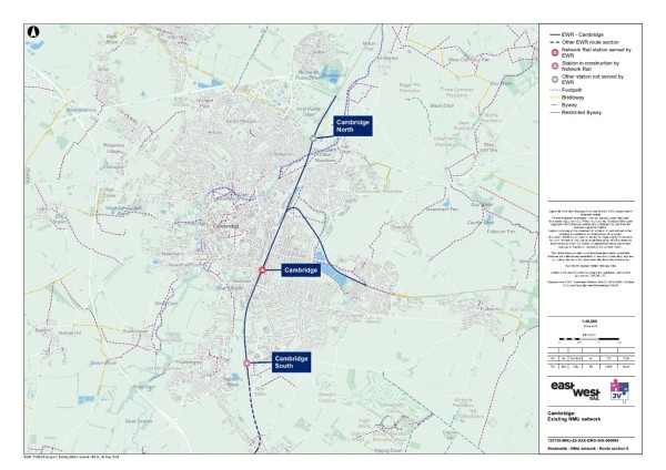
There are 16 PRoW within 250m (275 yards) of the EWR route, of which six cross the railway itself. There are no PRoW located in close proximity to Cambridge station. The PRoW that cross the EWR railway line are listed in Table 45.
Table 45 - PRoW crossing the EWR railway line
|
PRoW number |
PRoW type |
|
17 |
Footpath |
|
13 |
Footpath |
|
11 |
Footpath |
|
7 |
Footpath |
|
9 |
Footpath |
|
2 |
Footpath |
Source: OS Data.
Bus Network
The bus services that serve existing railway stations that will be EWR stations have been identified in Table 46. At Cambridge station entrance on Station Place there are nine bus stops with shelters (five northbound, four southbound).
Table 46 - Cambridge bus services
|
Service number |
Route |
Operator |
Frequency (per hour) |
EWR Station |
|
A the busway |
Cambridge to St Ives |
Stagecoach |
4 |
Cambridge |
|
U1/U2 |
Girton Corner/Eddington – Cambridge Biomedical Campus |
Whippet |
4 |
Cambridge |
|
3 |
Cherry Hinton – Fison Road |
Stagecoach |
4 |
Cambridge |
|
PR4 |
Cambridge City Centre to Babraham Road Park and Ride |
Park and Ride |
6 |
Cambridge |
|
X2 |
Cambridge to Huntingdon |
Whippet |
Twice a day |
Cambridge |
|
X3 |
Addenbrooke’s to Huntingdon |
Whippet |
1 |
Cambridge |
|
1 |
Arbury to Fulbourn |
Stagecoach |
6 |
Cambridge |
|
7 |
Emmanuel Street E1 – Saffron Walden Station Street |
Stagecoach East |
4 |
Cambridge |
|
132 |
Cambridge – Saffron Walden |
C G Myall & Son |
Every two hours (Sun only) |
Cambridge |
|
13 |
Cambridge – Haverhill |
Stagecoach East |
1 |
Cambridge |
|
The Cambridge Tour |
Cambridge City Centre |
City Sightseeing |
2 |
Cambridge |
Interchange at stations
Cambridge station
The connectivity of the station with other modes of transport is shown in Figure 87.
Figure 87 - Cambridge station facilities (transport)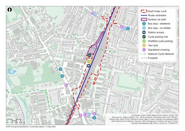
Cambridge station is located to the east of Cambridge city centre. Land use in the vicinity of the site is a mixture of commercial office and residential use. There is a dedicated drop off/pick up area outside the station. There is a car park with capacity for around 440 cars. Opportunities for on-street parking surrounding the station are extremely limited. There are controlled parking zones (CPZs) surrounding the station. Taxi rank facilities are just outside the station, as well as bus services to connect to different parts of Cambridge. There is the guided busway to connect the station to Trumpington Park and Ride, as well as Addenbrooke’s hospital.
Cycle parking facilities are provided at the station with stands for 2,850 cycles provided near to the car park and connectivity with dedicated cycling routes.
There is currently an electric bike and scooter hire scheme being trialled in the city, which at the time of writing is scheduled to end May 2024.
15.2 Future baseline
Future development and transport schemes
Changes to the transport networks would affect how they operate in the future. Additionally, changes to surrounding land use would change demand for use of these networks, meaning the future baseline situation could be dramatically different to the current 2023 baseline scenario, before the project is implemented. For all locations, this could include:
- Plannng applications submitted and approved for new developments or Local Plan allocations coming forward.
- Upgrades and improvements to transport infrastructure (highway, active travel and public transport networks).
The following network changes are expected to affect the further baseline for this section of the route:
- Cambridge South railway station - a new station adjacent to Cambridge Biomedical Campus is under construction and would sit on the EWR line and be managed by Greater Anglia.
- Cambourne to Cambridge (C2C) - a new dedicated busway route linking communities in Cambourne and Cambridge, via Hardwick, Coton and the West Cambridge campus. There will be a travel hub (Park and Ride facilities) at Scotland Farm to enable drivers to use the bus into Cambridge. A Transport & Works Act Order application is in progress to enable the scheme to progress. This could change highway demand in the city centre.
- Cambridge South East Transport (CSET) Phase 2 will provide a dedicated busway with adjacent active travel route between the A11 and the Cambridge Biomedical Campus via Sawston, Stapleford and Great Shelford.
Changes in traffic flow
Figure 88, Figure 89 and Figure 90 show the roads which are expected to operate at close to or over capacity without the project in the years 2032, 2034 and 2049.
Figure 88 - 2032 Volume over Capacity >=85% (without the project scenario)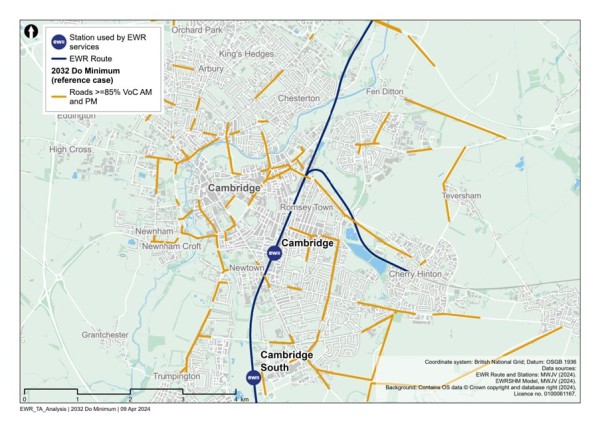
Figure 89 - 2034 Volume over Capacity >=85% (without the project scenario)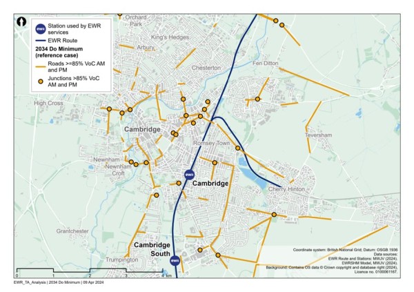
Figure 90 - 2049 Volume over Capacity >=85% (without the project scenario)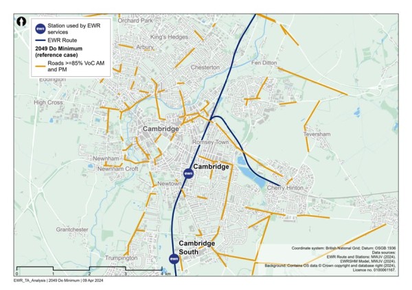
Figure 88, Figure 89 and Figure 90 show that between 2032 and 2049, there are a few additional roads that would operate at close to or over capacity including:
- The A14 on-slip at the junction with Horningsea Road.
- Station Road west of Cambridge station.
- King’s Hedges Road north of Chesterton.
15.3 Project proposals
This 8km (5 mile) section of the route would run from Addenbrooke’s Road bridge over the existing WAML north of Great Shelford, to the one section ending A14 bridge north of Cambridge North station and to Yarrow Road in Cherry Hinton to the east of Cambridge.
The proposed works are summarised as follows:
- Two new tracks that run adjacent to the existing two-track WAML from Addenbrooke’s Road, joining the existing four tracks at Cambridge South station (under construction at time of writing) and continuing into Cambridge station.
- Demolition of the road overbridge at Long Road and provision of a new bridge wide enough to fit the additional tracks.
- Construction of a new platform, platform extensions, bridges, building upgrades and railway systems modifications at Cambridge station.
- New train turnback facility at Cherry Hinton east of Cambridge and an additional track to a section of the existing Newmarket Line.
- Safety improvements to the existing level crossing at Laundry Lane in Cambridge.
- Reconstruction of two footbridges at Coldham’s Common and The Tins footpath to allow for the electrification of the railway and the addition of a second track.
- Reprovision of anexisting siding that would be lost due to works at Cambridge station to Chesterton sidings at Cambridge North station.
- Modifications to track layout works at Cambridge North station to allow some existing train services form the north to terminate there during our construction works.
- Several drainage and attenuation ponds along the route section.
The passenger train services proposed are:
- 2 x Oxford to Cambridge services in each direction per hour
- 1 x Stewartby to Cambridge service in each direction per hour
- 1 x Bedford to Cambridge service in each direction per hour
This is in addition to the non-EWR services that run on the route into Cambridge, as well as the other services that run north and east from Cambridge. Construction compounds and movements.
Three main construction compounds are proposed to support delivery of the programme in this section of the route along the WAML. These are:
- Granham’s Road compound - This is the first main compound and whilst located within the Comberton to Shelford Route Section, it supports works along the WAML. The compound would be located between existing railway corridor and the proposed extension of the Cambridge Guided Busway (CSET) near Shepreth Junction. This compound would sit within existing farmland and support the construction works along the existing railway corridor in the area of Shepreth Junction.
- Addenbrooke’s Road compound - This is the second main compound located to the west of the existing railway alignment and would be accessed from Addenbrooke’s Road. Again, whilst located within the Comberton to Shelford Route Section, it supports works along the WAML. This compound would work in combination with the Granham’s Road compound in the delivery of the rail systems and track works within the existing railway corridor.
- Long Road compound - This is the third main compound which is located off Long Road. This compound would support the construction works associated with the replacement of Long Road overbridge and the works along the existing railway corridor in this area.
Construction traffic routes to support the delivery of these works would be strictly controlled and the route to the nearest point of connection to the strategic road network (motorway and major A roads) would be assessed and defined to reduce the impact to the local area and stakeholders.
15.4 Potential impacts
A comparison has been undertaken between the 2032, 2034 and 2049 reference cases (no project) and the corresponding (with project) scenarios for those years, to determine what links become over capacity when project traffic is added to the network.
Figure 91 shows the links which become at or over capacity in 2032 because of construction traffic related to the project.
The roads identified include:
Figure 91 - Comparison of 2032 reference case (no project) vs 2032 with project: additional roads with a Volume over Capacity >=85%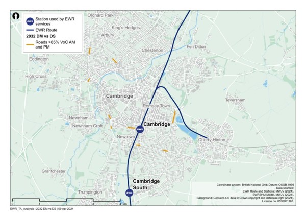
Figure 92 shows the additional roads with a VoC of greater than or equal to 85% in 2034 because of the project. The links include:
- Station Road.
- The A1307 Hills Road.
Figure 92 - Comparison of 2034 reference case (no project) vs 2034 with project: additional roads with a Volume over Capacity >=85%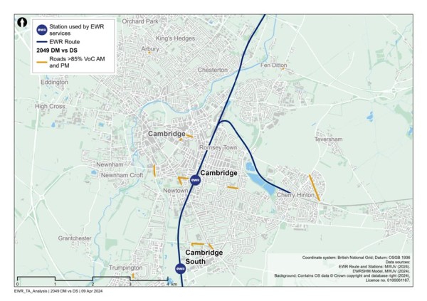
Figure 93 shows the additional roads with a VoC of greater than or equal to 85% in 2049 because of the project. The links include:
- Station Road.
- The A1307 Hills Road.
Figure 93 - Comparison of 2049 reference case (no project) vs 2049 with project: additional roads with a Volume over Capacity >=85%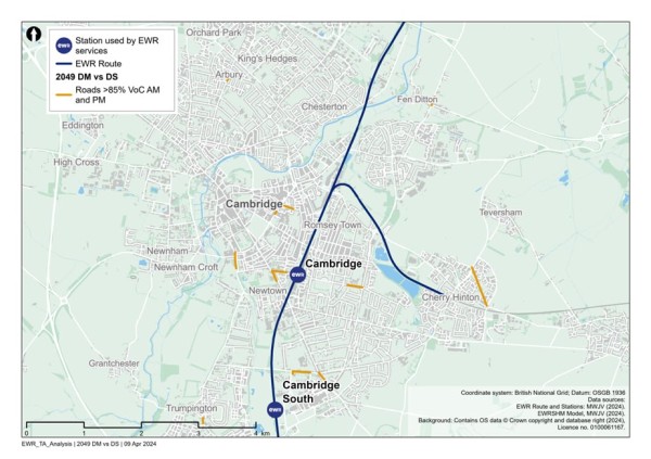
In addition to links which become over capacity in the ‘with project’ scenarios, there would be links that are already operating over capacity in the ‘no project’ scenarios, which are assessed to be pushed further over capacity in the ‘with project’ scenarios. These are not shown in the figures but would form part of further assessment in the TA and subsequent discussions with stakeholders regarding mitigation.
Based on the current design maturity, the following potential impacts in Table 47 could be realised within this study area section.
Table 47 - Cambridge potential impacts (transport)
|
Mode/Who |
Phase |
Change |
Potential impact prior to any mitigation |
|
NMUs |
Construction |
Temporary construction works, including traffic management, changes to utility infrastructure required for the project, may affect NMU access and movement. |
In some places, existing level crossings, user worked crossings and footbridges or underpasses crossing the railway may be closed temporarily to allow construction to be safely carried out and this may result in diversions. Temporary traffic management may result in diversion routes or temporary closure of crossing points or footways. |
|
Highway |
Construction |
Temporary traffic management may be required where the project affects the highway network. |
This may lead to delay on the highway network to pass through temporary traffic management measures, or use of diversion routes. The extents of these potential impacts have not yet been determined. The CTMP and CoCP would include provisions to reduce the impacts of these works on road users. |
|
Rail users |
Construction |
Some construction activities may require temporary suspension of rail services. |
Alternative transport would be provided where possible, in consultation with train operating companies and other affected stakeholders. |
|
Highway |
Construction |
Construction traffic movements on the network. |
Temporary traffic delay and/or congestion on the highway network, in particular routes which accommodate construction traffic. The CTMP and CoCP would include provisions to reduce the impacts of these works on road users. Interim modelling outputs provide initial information on potential locations of impact. |
|
Highway |
Construction |
Realignment of Long Road to accommodate the two new additional tracks required on the WAML. This would involve lifting the road and the reconstruction of the bridge that crosses over the railway.
Upgrading Laundry Lane level crossing to accommodate the introduction of the additional track. |
There will be delays to journeys whilst this is in construction and the requirement for temporary diversion routes to be in place. |
|
Rail users |
Construction |
Station enhancements at Cambridge station. Construction work associated with the enhancements may temporarily affect access to the station. |
There may be temporary impacts on station access for passengers. These impacts will be controlled by provisions within the CTMP and the CoCP, and coordinated with the station operator and train operating companies where access to train services is expected to be impacted.
|
|
NMUs |
Construction |
Reconstruction of two pedestrian bridges, at Coldham’s Common and The Tins footpath, to provide sufficient clearance for overhead electrification of the railway.
Upgrading Laundry Lane level crossing to accommodate the introduction of the additional track. |
This could lead to journey delay and increases in journey distance to utilise temporary diversion routes. The suitability of the temporary diversion routes for all users will be assessed once the design is confirmed. |
|
Rail users |
Operation |
Increased train frequency on the line and revised travel patterns in response to creation of new EWR services and stations along the route. |
Improved journey times for rail trips with a mode shift from car to rail due to enhanced station facilities and services. |
|
NMUs |
Operation |
Existing PRoWs which cross the proposed route alignment would require new crossing facilities or closure and associated diversions. |
This could lead to an increase in journey distance and journey time for NMUs. The suitability of diversion or alternative routes for all NMUs would be reviewed to ensure the proposed diversion routes are suitable, with mitigation proposed where required to enhance routes. |
|
Highway |
Operation |
Provision of new rail services would provide travel choice for longer distance trips supporting mode shift from car to rail. Additionally new or enhanced stations providing local access to rail services may also alter local trip patterns. |
Changes to highway demand due to mode shift from car to rail, or a change in local trip patterns with the opportunity to travel to (new) local stations to access enhanced or new rail services. This could result in some localised delay and congestion or see a reduction in traffic in some locations. Options for mitigation to provide additional capacity at locations will be reviewed and discussed with key stakeholders. |
[1] STATS19, DfT, 2018-2022.
16. Mitigation Strategy
A Mitigation Strategy is required to ensure that adverse effects associated with the project are suitably reduced or removed through the introduction of appropriate mitigation.
From a transport perspective, as highlighted in earlier chapters of this report, impacts are likely to be associated with changes in traffic flows on the highway network associated with construction traffic during construction, and associated with changes in demand and travel patterns during operation, which may cause congestion and associated journey delays. Where diversion routes are in place (highway, PRoW), these may mean changes to journey times as well as a need to determine whether the proposed diversion routes are suitable and appropriate for the proposed user. So, for example, there are suitable footways and crossing points on routes intended for NMUs.
The need for mitigation would be based on a series of thresholds which are set out later in this chapter, with parts of the project meeting these thresholds triggering the need for mitigation to be considered further. All transport mitigation would be discussed and agreed with the relevant stakeholders (for example local authorities or highway authorities) and if appropriate a monitoring regime established to review the effectiveness of the mitigation proposed.
Embedded mitigation
The project proposals are being developed taking account of transport, engineering, land, economic, cost, and environmental and community considerations. The route alignment, the design of the various project components, the proposed construction methods, the operation of the rail service, stations and other aspects and the servicing and maintenance of the project would each take account of these various considerations as they become increasingly well understood through successive stages of design and assessment.
The TA is and will continue to be instrumental in informing changes to the project design through its feedback on aspects of transport for all modes as well as all user types. The project proposals would therefore accommodate various embedded mitigation measures.
Construction and the Code of Construction Practice
The Construction Strategy would rely extensively on the application of a Code of Construction Practice (CoCP). This would be a fundamental part of the project proposals in that it would outline the measures needed during construction to avoid likely significant adverse effects on people and on natural and cultural assets. The TA would assume that these measures would, as a minimum, be implemented. The measures would represent a best practice approach and would be generic to most construction activity for a project of this nature.
Following consent, measures set out in the CoCP (including any changes to them required as part of the consent) would be used as the basis for more detailed measures that would be developed by the principal contractor. These measures would take account of the detailed designs, and to the specific approach to construction that they support, accommodating where necessary, local and specific sensitivities. For transport, there would be a CTMP and a Construction Workforce Travel Plan (CWTP) to manage and mitigate the impact of construction traffic. These Travel Plans and the CoCP would all be embedded in the project.
Mitigation thresholds (transport)
From a transport perspective, mitigation would be considered in the following instances:
- Where links or junctions are forecast in the traffic models to increase to a level that pushes them over capacity (defined as being over 0.85 VoC) in a ‘with project’ scenario (i.e., the difference between the ‘with project’ scenario and the baseline scenario), or locations which were already operating over capacity within the baseline scenario, which are then further increased in the ‘with project’ scenarios. Mitigation considerations for these locations could include any combination of:
- Changes to junction layouts or operation.
- Changes to link widths, layouts, or configurations.
- Changes to signage to manage route choice.
- Changes to the provision of NMU crossing facilities or infrastructure.
- Changes to the provision of on-street parking, traffic regulation orders or markings.
- Where links are set to have an increase in traffic by 30% or more (from the relevant baseline scenario), a review of road casualty data would be undertaken for the link to consider if there are any existing safety concerns that may require mitigation, with this to be discussed with relevant stakeholders. Locations along the link would be identified through professional judgement. The 30% threshold is shared with the EIA and based on Institute of Environmental Management and Assessment (IEMA) guidelines. The type of mitigation would be dependent upon the safety concern identified.
- Where buses are diverted along a new route the suitability of this route would be considered in terms of its width, restrictions such as bridges or corners and the location of bus stops and how these are accessed. Mitigation could include enhanced provisions at bus stops, changes to bus stop layouts, widening at pinch points and signage.
- Where NMUs are diverted along an alternative route, the suitability of this route would be considered to include the provision of footways, crossing points and connectivity with existing infrastructure/wider network. This would be considered against current, relevant design standards such as LTN1/20 and Manual for Streets and mitigation could include the introduction or update to crossing points, cycle infrastructure or footways.
- Where there are proposed changes to station operations on account of operation of the EWR services at existing stations, the impact upon station operation and service provision would be reviewed. Station impacts could include any change to station facilities and operations for buses, taxis, pedestrians and cyclists, with mitigation likely to be embedded into design but could include the introduction of new crossings, footway upgrade, provision of cycling infrastructure to connect with nearby network or better bus stop provisions, all in the vicinity of the station.
- The implementation of appropriate travel plans to actively manage access and mode choice to stations, which would include the provision and management of on-site parking and infrastructure to support access by NMUs.
Given the temporary nature of the construction scenario, the suitability of mitigation at locations which would experience construction impacts would be reviewed to take into consideration the duration of the impact. This would be agreed with stakeholders but mitigation in some instances could be temporary.
Mitigation assessment
Once mitigation has been identified and designed (to relevant design standards), for mitigation schemes which involve changes to the highway network, the suitability of the mitigation would be tested through traffic modelling. It is proposed that the following modelling scenarios would be assessed to review mitigation:
- 2032 Construction scenario with the project (construction) and with mitigation.
- 2034 Opening year scenario with the project (operation) and with mitigation.
- 2049 Opening year scenario with the project (operation) and with mitigation.
The testing would be an iterative process with outputs from the assessment being used to refine the mitigation design.
The suitability of other mitigation would be confirmed through a combination of the application of professional judgement, incorporating feedback from relevant stakeholders and the review of mitigation against relevant policy documents and design guidance.
Monitoring
There may be a requirement for monitoring of some impacts and locations, which could:
- Review the effectiveness of implemented mitigation to allow early identification of where further mitigation may be required.
- Review locations where levels of impact were initially not deemed sufficient to warrant mitigation (by agreement with stakeholders) but where mitigation may become necessary if impacts are realised differently.
The approach to monitoring would be set out in the TA and require the support of relevant stakeholders. The approach would include what information would be collected to inform the monitoring process and how this would be utilised.
17. Uncertainty
As noted in the TA Scoping Report (Appendix A), once the design is finalised, it would be necessary to consider future uncertainty and the impact this could have upon the mitigation being effective or the impacts being realised as initially thought.
Uncertainty is inherent in any transport modelling exercise where we predict future outcomes years ahead. We can never be sure what will happen in the future or ever be certain the outcomes we predict in our modelling will materialise exactly as we envisage. We cannot eliminate uncertainty from our work but can account for it and report it where practical using appropriate sensitivity/scenario tests.
As part of the development of the TA, we will engage with stakeholders on possible future transport outcomes in their individual areas. We will develop three to four future alternative scenarios based on these discussions, with reference to the DfT ‘TAG Uncertainty Toolkit’. The primary assessment would represent a ‘reasonable worst case’ scenario which would test the impact of the project as it is proposed. Any proposed mitigation which would accompany the project would be based on this primary scenario.
The sensitivity scenarios would be reported on in qualitative terms outlining the likely high-level impact on the conclusions of the primary assessment. At present full discussions with stakeholders have not yet taken place on these issues however sources of uncertainty could include:
- Travel behaviour uncertainty:
- Digital infrastructure and services reducing need to travel.
- Changes in demand for active travel.
- Economic uncertainty:
- Changes in growth and development in areas impacting demand for travel.
- Transport network/supply:
- Delivery of infrastructure/transport projects.
- Future public transport services.
- Capacity of rail network.
These would be agreed with key stakeholders as the design of the project progresses prior to submission of the DCO application and be reported on in the TA.
The key purpose of the TA is to assess the potential transport impact of the project and ensure mitigation is appropriate. The potential difference between the outcomes of the primary assessment and the sensitivity scenarios will be discussed in qualitive terms.
18. Next Steps
Following the non-statutory consultation, comments and feedback received from stakeholders on the TA Scoping Report (Appendix A) and this TUR will be reviewed and used to shape the development of the draft TA which will be shared at the statutory consultation before being finalised for submission with the DCO application.
Design proposals will continue to be refined and optimised, with a focus on sustainability and mitigation of potential environmental effects, cost reduction, constructability and reducing impacts on traffic and transport.
As part of embedding mitigation of transport impacts into the design process, the TA team will be working closely with the design team as a preferred, single design is identified for the project. This final design will form the basis of the future assessment work to be reported in the draft TA which will be shared at the statutory consultation, before being finalised for the DCO submission.
Appendix A - TA Scoping Report
Abbreviations and Descriptions
Table A1 - Abbreviations and Descriptions
|
Abbreviation |
Definition |
|
BBC |
Bedford Borough Council |
|
BC |
Buckinghamshire Council |
|
BOAT |
Byways Open to All Traffic |
|
Cambs CC |
Cambridgeshire County Council |
|
CBC |
Central Bedfordshire Council |
|
CCC |
Cambridgeshire City Council |
|
CDC |
Cherwell District Council |
|
CLS |
Construction and Logistics Strategy |
|
CoCP |
Code of Construction Practice |
|
CTMP |
Construction Traffic Management Plan |
|
DCO |
Development Consent Order |
|
DfT |
Department for Transport |
|
EEH |
England’s Economic Heartland |
|
EIA |
Environmental Impact Assessment |
|
ES |
Environmental Statement |
|
EWR |
East West Rail |
|
EWR Co. |
East West Rail Company |
|
HDC |
Huntingdonshire District Council |
|
HGV |
Heavy Goods Vehicle |
|
MKC |
Milton Keynes Council |
|
NMU |
Non-Motorised User |
|
OCC |
Oxfordshire County Council |
|
Oxford CC |
Oxford City Council |
|
PRoW |
Public right of way |
|
SC |
Statutory Consultation |
|
SCDC |
South Cambridgeshire District Council |
|
SODC |
South Oxfordshire District Council |
|
SRN |
Strategic Road Network |
|
TA |
Transport Assessment |
|
TUR |
Transport Update Report |
|
TWAO |
Transport and Works Act Order |
|
VoC |
Volume over Capacity |
|
WAML |
West Anglia Main Line |
A1. Introduction
Overview
East West Rail (EWR) is a once-in-a-generation opportunity to connect people and businesses in the communities between Oxford, Milton Keynes, Bedford and Cambridge, making it easier, faster and more affordable to get around the region. It would also bring the rest of the UK closer by intersecting with the East Coast Main Line, Midland Main Line and West Coast Main Line.
This document
In preparation for the DCO, there will be a statutory consultation to provide opportunity for stakeholders to provide comment on the proposals and for these comments to be considered and addressed and re-presented.
In terms of the production of the final TA, it will be a gradual collation of more detail and evidence, and is proposed to be drafted and shared as per:
- The Transport Assessment Scoping Report (this document).
- The Transport Update Report (TUR) - a largely qualitative report as a precursor to a draft TA which this is an appendix to and provides some early information on possible transport impacts.
- A Draft TA (greater quantitative inputs) which will be shared for the Statutory Consultation.
- The final Transport Assessment for DCO submission.
The purpose of the TA is to undertake an assessment and appraisal of the project, both during construction and operation, in terms of the traffic and transport impacts and mitigation. The TUR will be a lighter, earlier version of the Preliminary TA, shared for early consultation feedback in 2024 and will be more qualitative in nature, reflecting the progress of the project in terms of its design maturity and the assessment of this. As the design progresses and the assessment tools and data sources (highway models and data collection) become available, the assessment work can be more quantitative in nature for the draft and subsequent final TA for the DCO.
Transport impacts are also being considered as part of an Environmental Impact Assessment (EIA) which has a separate Environmental Statement (ES) Scoping Report produced to cover the approach taken for traffic and transport.
This Scoping Report sets out more information on the scope of assessment to be covered and the corresponding content of these documents. It has been prepared to inform discussions with the highway/transport authorities regarding the scope and form of the early TUR, the subsequent Preliminary Transport Assessment (TA) and then the final TA.
This Scoping Report sets out the methodologies and approaches to be used across the assessment from TUR through to TA. Since the project and associated impacts will cross the boundary of several local authority areas, the aim of this scoping report is to ensure that there is consistency in the approach to assessment across the route.
The DCO is for the railway scheme only. It does not apply for permission for any ‘dependent developments’, that is housing or commercial developments that are expected to come forward as a result of the railway scheme. The designs that are being developed for the project take into account different options for growth in jobs and housing so that there is the infrastructure in place or can be put in place at a later date, to ensure that EWR is not a limitation on growth in the area. However, the TA will not consider specific development options but rather consider the impacts of more general growth, that is committed developments, local plan allocations and general growth over a wider area which will vary by scenario and by assessment year.
Study area
The project will be predominantly a linear corridor of new rail or improvements to existing rail infrastructure. This infrastructure will have impacts associated with the operation of the railway, for example through additional patronage and existing or new stations, as well as for the construction of the railway.
To focus information, for the TUR, the project route alignment will be split into eight geographical sections, within which we provide information on baseline and preliminary highway impact information. These sections are as follows:
- Oxford to Bletchley: This route section between Oxford and Bletchley approximately 48km (30 miles) long, would use the existing section of operational railway between Oxford and Bicester. It would then continue onto the reinstated section of railway between Bicester and Bletchley currently being built as part of EWR Connection Stage 1.
- Fenny Stratford to Kempston: This route section includes an existing railway between Bletchley and Bedford, known as the Marston Vale Line. The route section covers approximately 23km (14 miles) between Saxon Street, Bletchley and Ampthill Road in Kempston, Bedford.
- Bedford: This route section through Bedford would be approximately 5.4km (3.4 miles) long, extending north from Ampthill Road in Kempston, to Clapham Road, south-east of Clapham village, next to the River Great Ouse.
- Clapham Green to Colesden: This route section between Clapham on the northern edge of Bedford and Colesden west of A1 Black Cat Roundabout comprises an approximately 12km (7 miles) section of the railway and would require entirely new infrastructure and the construction of a two-track railway.
- Roxton to east of St Neots: This route section comprises a new two-track railway, would cover approximately 10km (6 miles), between South Brook west of Roxton, and the roundabout between the B1428 Cambridge Road and the existing A428 to the east of St Neots.
- Croxton to Toft: This route section comprises a new twin-track railway, covering approximately 19km (12 miles) from the roundabout east of St Neots where the B1428 Cambridge Road joins the A421 extension (currently being built as part of the A428 Black Cat to Caxton Gibbet Improvement Scheme) to the B1046 between Toft and Comberton.
- Comberton to Shelford: This route section covers approximately 14.3km (8.9 miles) and would involve using existing railway as well as the construction of new railway tracks and supporting infrastructure.
- Cambridge: This route section would be approximately 8km (5 miles) long and would extend from Addenbrooke’s Road bridge over the existing West Anglia Main Line (WAML), north of Great Shelford, to the A14 bridge north of Cambridge North station, and to Yarrow Road in Cherry Hinton at Cambridge East, on the Newmarket line.
The precise extents of the study are not possible to define at this stage given the design is not yet finalised and modelling complete, and it is possible that locations that some impacts are identified sitting outside of these initial study areas. For the TA the study area will comprise of all locations identified where there is potential for traffic and transport impacts.
Stakeholder engagement
An intrinsic element to the preparation of the Scoping Note, TUR and TA will be stakeholder engagement with local, regional and national bodies, as well as feedback from the public through the non-statutory and statutory consultation process.
At this stage, it is envisaged the following organisations will be consulted on traffic and transport matters during the process of producing the Scoping report:
- Department for Transport (DfT).
- National Highways.
- Network Rail.
- Active Travel England.
- Local highway authorities along the route (see below).
The project will likely have multiple traffic and transport impacts in several local authority areas. Table 2 provides a list of those authorities likely to be impacted, both local highway and planning authorities. In addition, the strategic road network (SRN) will also be impacted as will parts of the rail network.
The following table provides a comprehensive list of the key stakeholders to be consulted as the TUR and TA are developed.
Table A2 - Highway and Local Planning along the route of EWR
|
National Authorities |
|
Network Rail (for the rail network) |
|
National Highways (for the SRN) |
|
Active Travel England (for PRoW) |
|
Local Highway Authorities |
|
Oxfordshire County Council (OCC) |
|
Buckinghamshire Council (BC) |
|
Milton Keynes Council (MKC) |
|
Central Bedfordshire Council (CBC) |
|
Bedford Borough Council (BBC) |
|
Cambridgeshire County Council (Cambs CC) |
|
Local Planning Authorities |
|
Oxford City Council (Oxford CC) |
|
South Oxfordshire District Council (SODC) |
|
Cherwell District Council (CDC) |
|
Buckinghamshire Council |
|
Milton Keynes Council |
|
Central Bedfordshire Council |
|
Bedford Borough Council |
|
Huntingdonshire District Council (HDC) |
|
South Cambridgeshire District Council (SCDC) |
|
Cambridge City Council (CCC) |
|
Others |
|
To be identified and agreed as design and assessments progress |
If during the duration of the study further transport impacts are identified in highway and planning authorities not listed in Table A2 above, then these authorities will be engaged with at the appropriate time.
This list is not exhaustive and other stakeholders may be identified and engaged with as the work progresses, with engagement focussed on certain elements of the project or in certain locations.
As appropriate stakeholders will be consulted throughout the development of the TUR and TA. Records of key discussions would be included in the TUR and TA as appropriate.
At this stage, the submission of this Transport Assessment Scoping Report we request comment and agreement on the extent of assessment and general approach.
A2. Policy and Guidance
Introduction
As the TA will be underpinned by relevant national planning policy and best practice guidance. They will also include a summary of current, and emerging, regional and local planning and transport planning policies and guidance relevant to the project. At this stage of the scoping process, the following documents have been considered, although the development of the TA will not necessarily be limited to these.
A first review of policy guidance will be presented in the TUR and this will be reviewed, added to and updated as necessary for the TA as new revisions or new relevant documents are released.
National policy
The TA will be undertaken in accordance with national guidance and best practice for appraisal of major infrastructure schemes. These will include (but not be limited to) the following documents:
-
- National Networks National Policy Statement, December 2014, and the draft revised version (2024) approved in March 2024 and at the time of writing awaiting designation.
- National Infrastructure Delivery Plan 2016-2021, March 2016.
- National Planning Policy Framework, December 2023.
- Transport Investment Strategy, July 2017.
- Gear change: a bold vision for cycling and walking July 2020 (Active Travel England).
- DfT Circular 01/22 strategic road network and the delivery of sustainable development.
Regional and local policy
Regional and local policy of relevance to the project will be considered and reviewed to establish the policy context. These will include (but not be limited to) the following documents or any successor documents where these are replaced during the development of the project:
- Regional Plans and Strategies:
- England’s Economic Heartland (EEH) Regional Transport Strategy: Connecting People, Transforming Journeys (2021).
- Local Transport Plans (LTPs):
- Oxfordshire Local Transport and Connectivity Plan, July 2022.
- Buckinghamshire’s Local Transport Plan 4, December 2016.
- Mobility Strategy for Milton Keynes 2018-2036 (LTP 4) Mobility for All, March 2018.
- Central Bedfordshire Local Transport Plan 3, 2011.
- Bedford Borough Local Transport Plan 2011 to 2021 (2011) and supporting strategy documents.
- Cambridgeshire and Peterborough Combined Authority Local Transport and Connectivity Plan, 2020.
- Local Plans to include any that are in the process of being updated:
- Oxford Local Plan 2036 (adopted June 2020).
- Cherwell Local Plan 2011-2031 (adopted July 2015).
- Vale of Aylesbury Local Plan 2013-2033.
- Milton Keynes Council: Plan MK 2016 - 2031 (adopted March 2019).
- Central Bedfordshire Local Plan 2015 - 2035 (adopted July 2021).
- Bedford Borough Local Plan 2030 (adopted January 2020).
- South Cambridgeshire Local Plan (adopted (September 2018).
- Huntingdonshire’s Local Plan to 2036 (adopted May 2019).
- Cambridge Local Plan 2018 (Adopted October 2018).
- Local Policies as contained in Supplementary Planning Documents.
The TA will be undertaken in accordance with regional guidance and best practice. These will include (but not be limited to) the following documents:
- Transport for New Developments: Transport Assessments and Travel Plans, Oxfordshire County Council, 2014.
- Transport Assessment Guidelines, Cambridgeshire County Council, 2019.
Any transport schemes or initiatives included in Local Plans or LTPs will need to be taken account of in any proposed mitigation as part of the project.
National guidance and best practice
The TA will be undertaken in accordance with national guidance and best practice for appraisal of major infrastructure schemes. These will include (but not be limited to) the following documents:
- Cycle Infrastructure Design (LTN 1/20), Department for Transport, 2020.
- Guidance on Travel Plans, Transport Assessments and Statements (Ministry of Housing, Communities and Local Government, 2014).
- Transport for New Developments: Transport Assessments and Travel Plans, Oxfordshire County Council, 2014.
- Implementing ‘Decide and Provide’: requirements for Transport Assessments, Oxfordshire County Council, 2022.
- Transport Assessment Guidelines, Cambridgeshire County Council, 2019.
- Buckinghamshire Council - Travel plans: Guidance for Developers, 2022.
A3. The project
Introduction
The TA will set out material details of the proposed project during the operational and construction phases. The TUR will provide a high-level overview of the proposed project for operational and construction phases to be based on the most current design, which may still include optionality.
This section of the scoping report provides a summary overview of the project.
Project overview
East West Rail services will be delivered in three stages - and some of these have already been granted planning consent:
- Connection Stage 1: East West Rail services would run from Oxford to Bletchley/Milton Keynes. Planning consent was granted via a Transport and Works Act order (TWAO) and new tracks have now been built before passenger services start running from 2025.
- Connection Stage 2: Building on the work completed in Connection Stage 1, East West Rail services would then extend from Oxford to Bedford. Consent has been granted here too through the TWAO and permitted development. We expect train services to run from Oxford to Bedford from 2030.
- Connection Stage 3: This stage completes the proposed railway and would see services run from Oxford to Cambridge via Bedford and Bletchley. The new section of track between Bedford and Cambridge requires planning consent via a Development Consent Order (DCO).
Trains are already running between Oxford and Bicester and earlier this year the final section of the 66km (41 miles) of new track connecting Bicester with Bletchley was laid. Remaining work in Connection Stage 1 includes the installation of signalling, testing and the construction of Winslow station, before passenger services start from 2025.
The works needed for Connection Stage 2 and Connection Stage 3 that will be included within the proposed DCO application, are referred to as the ‘project’.
The project includes the following main works:
- Construction of a new railway between Stewartby and Cambridge including the construction of new stations and car parks at Tempsford and Cambourne.
- Improvement works to the existing railway between Oxford and Bedford and the approach into Cambridge, including works to ensure adequacy of stations for expected passenger demand.
- New structures and works to existing structures including viaducts, tunnels, bridges, cuttings and embankments.
- Improvements to or closure of level crossings and the provision of suitable replacement crossings where required on safety grounds.
- Works to manage interfaces with existing highways and public rights of way, watercourses and utilities apparatus.
- Environmental mitigation to mitigate the impacts of our proposals.
Construction programme
The TA will set out details of the EWR construction programme and construction phasing. The phasing will likely include:
- Enabling works such as movement of utilities and upgrades to transport infrastructure in order to build EWR.
- Main civils works including site set up, structures and earthworks.
- Railway systems including interfaces with existing networks, maintenance depot, railway systems installation, testing and commissioning.
Across the entire project the peak in construction traffic will be associated with the main civils work. Construction compounds will be in place and there will be designated routes for construction traffic to follow to access these from the SRN.
Construction strategy
To deliver the project in an efficient and cost-effective manner, without excessive disruption and impact on the environment and neighbouring communities, will require the development and implementation of a robust overall Construction and Logistics Strategy (CLS) for the project that will be adopted by all contractors and suppliers.
This strategy will include lessons learnt from the construction work undertaken to date between Oxford to Bletchley (which does not form part of the project) and cover, inter alia, such elements as the following:
- Optimising the railway alignment, where practicable, to balance ‘cut and fill’ volumes.
- Implementing an environmental management system, to minimise the environmental risks and impacts of the project throughout its design and construction (including measures for relocation of wildlife; control of noise, dust and vibration; minimising waste; landscaping; and planting).
- Developing and implementing the draft Code of Construction Practice (CoCP), which will define the responsibilities and requirements of the various contractors.
- Working with local highway authorities and National Highways to ensure use of the strategic and local highway network by construction traffic is managed and to ensure that it is restricted to those routes which have the capacity to safely accommodate the additional traffic.
- Minimising use of road transportation, where reasonably practicable, for both workers and materials, including use of rail access.
- Utility diversions, including agreeing responsibilities for designing and implementing diversions with the statutory undertakers and utility owners.
In relation to traffic and transport, during construction works, the impacts on local communities from construction traffic will be reduced by contractors and public access maintained, where reasonably practicable. The impact of road-based construction traffic will be minimised by identifying clear controls on vehicle types, hours of site operation and specified routes for large goods vehicles.
Highway works required to accommodate construction traffic will be identified. Where reasonably practicable, the number of private car trips to and from site (both workforce and visitors) will be minimised, by encouraging alternative modes of transport.
As summarised below a series of general construction traffic management measures will be identified.
- Measures to provide for road safety, for members of the public and construction staff during traffic management works, including temporary traffic control measures.
- Procedures to be followed for the temporary or permanent closure or diversion of roads or accesses.
- Procedures to maintain pedestrian, equestrian and cyclist routes, where reasonably practicable.
- Measures to be implemented to reduce construction traffic impacts or impacts associated with parking on residential streets.
- Access to the construction works.
- Permitted access routes for construction traffic.
- Requirements for monitoring and engagement/interaction with local highway authorities.
More detailed measures will be developed on a site-by-site basis according to the local conditions. As part of the CLS, a Framework Construction Travel Plan will be prepared that will be the basis for specific Construction Travel Plans to be produced to reflect specific issues at each compound. A Code of Construction Practice and a Construction Traffic Management Plan (CTMP) will also be produced.
A4. Baseline Conditions
Introduction
The TUR will set out the baseline transport and traffic conditions along the proposed EWR route alignment as well as along the proposed construction routes for the project. This will be updated as necessary for the TA to account for any changes which may have occurred between the two documents.
Baseline study area
The study area will need to include all of the areas that are potentially impacted during construction and operation of the project, along the full corridor. The extent of the assessment study area will depend on what transport topic is being assessed and this is set out more clearly in Sections A6 (for Construction) and A7 (for Operation) of this report. The study area will include:
- Existing stations where changes are recommended to access, service frequency or station (transport) facilities such as parking or interchange.
- Locations of new stations and their relevant transport facilities.
- Level crossings which are to be closed and diverted and the associated diversion routes.
- Any amendments to the highway network required to accommodate stations, diversion routes or construction compounds (e.g., intermediate junction upgrades, crossing provisions or changes to carriageway). This would include any amendments required to bridges (under or over).
- Highway network routes which will accommodate construction traffic movements and linked to this, construction compound locations and their connectivity with the strategic road network (SRN).
- Interfacing Non-Motorised User (NMU) network of any of the above.
- Public right of way (PRoW) network which is to be severed, diverted or closed.
The baseline summary in the TA will include the following information:
- Highway network - local and strategic networks to include existing roads, junctions, bridges, general network layout and functionality based on the study area above. The description of the highway network will provide an overview of the strategic network (including motorways) and the local network (including secondary routes and other local roads) which may be affected by the project. The section will seek to identify any constraints and summarise baseline and daily peak hour traffic flows and provide a review of road casualty data to identify any baseline safety issues.
- Based on the review of the highway network, the location of parking and/or loading restrictions which may have an impact on the appraisal of the project in the area will also be noted. Consideration will be given to parking related issues such as areas where parking may create a bottleneck or at times of day such as school pick-up/drop-off or servicing of facilities, or where parking could be problematic for performance of the highway network.
- Road traffic collisions and safety review (STATs19 data) for links and junctions along constuction routes, around highway modification (mitigation) locations to accommodate EWR, along diversion routes, near to construction compounds, or near stations or level crossings, for up to the last five years (or as available).
- Public transport (bus) network to cover routes, stops, frequencies for services which interface with an EWR station, level crossing or diversion route.
- Rail network (routes, stations, frequencies) and for the stations information on existing transport facilities such as parking, access and on-ward connectivity/interchange.
- Level crossing locations and functionality.
- PRoW network including footpaths, bridleways, Byways Open to All Traffic (BOATs) and restricted byways, where these interface the EWR route and interface with stations, level crossings or diversion routes.
- Surrounding planning context (land use) around EWR impacts, and where appropriate Local Plan allocations.
- Future changes to baseline will be noted where known (for example changes to land use, any committed or planned highway or transport schemes).
The TUR and TA will identify the nature of the land use within the area surrounding the project as set out above (predominantly agricultural, urban etc) and seek to identify any existing community facilities on which the impact of the project may need to be considered.
Surveys to inform existing baseline
The need and reliability of existing and potential data sources has been identified and survey scopes have been developed to provide updated information on traffic flows, pedestrian movements at stations and NMU movements to inform the baseline and to feed into the highway modelling.
Survey data, including traffic count surveys, level crossing surveys, NMU surveys and rail station surveys (passengers, car parks, access), is being collected to provide up to date survey information to support any existing data sets available from stakeholders.
Future baseline
Land uses
This section will set out any major committed developments relevant to the year of assessment, as defined in accordance with Transport Analysis Guidance (TAG), or land use changes which may impact on the future baseline conditions within the area. Information on committed development(s) within the respective local authority areas will be obtained at the local level, through liaison with the relevant planning departments, and then, as necessary, fed into the TA work. Commentary will be provided in the TUR on any identified committed development.
Where there are no major committed developments or land use changes, the section will set out the approach adopted to determining the future baseline conditions where it differs from the route-wide approach.
Dependent development is not proposed to be considered as part of the TUR or TA. This will be kept under review and should notable developments be identified; these would be considered on a case by case basis as to if or how they are considered further.
Transport network assumptions
This section will set out any major committed or known changes in the transport network which may influence the future baseline conditions within the study area.
The most significant highway scheme in the study area is a new 10-mile dual carriageway is being constructed by National Highways as part of A428 Black Cat to Caxton Gibbet improvement scheme (the A428 scheme). The new dual carriageway will be a continuation of the existing A421 and upon opening, National Highways will refer to the new dual carriageway as the A421. It will therefore be referred to as the new A421 dual carriageway within these documents. A DCO was submitted in February 2021 and granted development consent in August 2022. Construction commenced in 2023 with completion scheduled for 2027, which should avoid the project construction period.
Discussions with local highway authorities will confirm if any other transport schemes need to be considered within the TA.
Transport network assumptions will need to be agreed with the relevant highway authorities and a level of uncertainty applied.
Future baseline conditions
Taking account of the proposed land use and transport network assumptions, this section will set out the future baseline transport network conditions in the construction assessment year, the year of opening and the future assessment year within the Study Area. In particular, this section will consider:
- road network traffic flows - taking account of the proposed land use and transport network assumptions, this section will set out the future baseline conditions in the construction assessment year (single scenario), the year of opening and the future assessment year within the study area with use of appropriate highway models to assess impacts.
- road traffic collisions and safety - any potential issues identified with road traffic collisions and safety in the transport network which may influence the future baseline conditions within the study area.
- parking and loading - any potential parking or loading changes in the transport network which may influence the future baseline conditions within the study area.
- rail - any major committed or known changes in the rail network which may influence the future baseline conditions within the study area.
- local bus - any major committed or known changes in the bus network which may influence the future baseline conditions within the study area.
- public transport interchanges - any major committed or known changes in public transport interchange which may influence the future baseline conditions within the study area.
- NMU provision - any major committed or known changes in pedestrians, cyclists and equestrians’ provision which may influence the future baseline conditions within the study area.
A5. Scope of Assessment
Construction and operation
The TA will assess both construction and operational phases. For construction, the impacts of the construction activities including movement of workers and materials and any significant temporary closures of transport infrastructure will be assessed against a common assessment year irrespective of when in the construction programme the impact occurs, i.e. a single scenario is to be assessed.
The TA will address local, route-wide impacts and off-route impacts and adopt an appropriate, proportionate approach to assessment and any necessary mitigation of adverse effects of the project.
The TA will provide information in relation to construction compound locations, route to and from the SRN and any applicable construction programme and will identify impacts and mitigation associated with construction.
The basis for the assessment in the TA will assume existing and committed developments locally, although traffic growth rates will come from the strategic traffic model, which takes account of existing and committed developments locally together with national forecasts included in NTEM8 (TEMPro) and are likely to include wider growth and development that is not yet approved. As such, the assessment will, in effect, be considering the cumulative impact of the project with other development. A single core scenario or reference case, for each assessment year, will be prepared.
The traffic impact of the project will be appraised through strategic modelling, and where necessary local junction modelling. The strategic model(s) will be used as the primary tool. Local junction models will only be used in any areas not covered by the strategic model and at complex junctions which cannot be effectively replicated by the strategic model. These will be discussed and agreed with stakeholders.
A dual approach is being taken for modelling. To inform the TUR and non-statutory consultation exercise, as well as to support design evolution of the project, the modelling approach is to make best use of available Local Authority transport models (namely: Bicester, Milton Keynes, Bedford and Cambridge) that cover the detailed modelled area for the project. Use of and outputs from a number of Oxfordshire models (excluding Bicester) are not being pursued.
All the local models are being updated to 2023 via a high-level growth forecast (with a COVID adjustment where necessary) and future year models for 2032 (construction year), 2034 (opening year) and 2049 (design year) being developed.
It is recognised that there will be phasing for both construction and operation, with some sections of the route in the west constructed and therefore operational earlier than other sections. However for the purposes of assessment, to capture a worst case scenario, a collective single year for construction (2032) and opening year (2034) will be used in the TUR and TA.
The TUR will provide a qualitative summary of the findings from this initial modelling exercise.
A new bespoke strategic highway model is under development at present which will cover the entire EWR route and will be used to provide information to be assessed within the TA to feed into the statutory consultation and DCO. This will cover the same assessment years and scenarios.
The purpose of any modelling work will be to ensure that the effects of construction and operation are duly considered. Information from the modelling exercises will therefore inform:
- the TUR (qualitatively).
- TA (as outlined above).
- traffic and transport elements of the EIA.
- by providing traffic data to inform other EIA disciplines including for example noise and air quality.
With regards to the assessment of the operational impacts of the project, an assessment of impacts of rail passenger demand arising from EWR as well the more localised impacts of any permanent road closures, new highway infrastructure or diversions will be undertaken within the models through assessment of future year scenarios. In terms of passenger demand this will take account of modal shift which will occur on account of the project and how these passengers access the EWR stations.
In terms of the rail passenger demand, the forecast demand will be derived from the EWR passenger forecasting model used to support the outline business case for the project. This demand will not include demand associated with dependent developments.
Assessment years and periods
The following table sets out the scenarios and assessment years to be used in the assessment and when these will be available in terms of being used for the TUR and TA. For the TUR, any available modelling data available at the time will be used to inform the qualitative approach proposed.
Table A3 - Assessment scenarios and years
|
Scenario |
Year |
TUR? |
TA? |
|
Baseline |
2023 |
Yes |
Yes |
|
Construction reference case |
2032 |
Yes |
Yes |
|
Construction + project construction traffic |
2032 |
Yes |
Yes |
|
Construction + project construction traffic + mitigation |
2032 |
No |
Yes |
|
Opening year (operational) reference case |
2034 |
Yes |
Yes |
|
Opening year + project |
2034 |
Yes |
Yes |
|
Opening year + project + mitigation |
2034 |
No |
Yes |
|
Future year (operational) reference case |
2049 |
Yes |
Yes |
|
Future year + project |
2049 |
Yes |
Yes |
|
Future year + project + mitigation |
2049 |
No |
Yes |
A common future baseline year will be used for the assessment of all construction impacts, with relevant construction traffic or interventions assessed against the future baseline year irrespective of when they occur in the construction programme. This is likely to be 2032. This approach will ensure that a consistent method is adopted across the full extent of the project.
The current view is that the assessment of the operational stage will be undertaken for 2034 (year of opening) and 2049 (future year). The choice of these years reflects an allowance for the ‘ramp up’ of services after the full service becomes operational and to ensure new infrastructure has adequate design life.
The assessment of junction performance will consider the morning and evening peak hour periods.
Where impacts are identified, additional modelling utilising local junction modelling tools may be necessary to better understand the impact and/or to identify and test mitigation. The locations to be assessed using Local Junction Models will be discussed and agreed with relevant local authorities and details on the methodology applied captured in technical modelling documentation.
A6. Construction Phase Assessment
Introduction
The impacts of construction activities including movement of workers and materials and any temporary closures and restrictions of transport infrastructure will be assessed against a common assessment year (2032) irrespective of when in the construction programme the impact occurs. The approach to managing any disruption would be set out as part of the Construction Logistics Strategy.
The main impacts are associated with construction traffic and disruption due to temporary closures and restrictions of highways and PRoW. Closures and restrictions that do not have substantial impacts and/or are of limited duration would not be assessed with such instances to be agreed with relevant local highway authorities and/or National Highways as appropriate.
The TA will provide an overview of the expected construction traffic routes, compounds and likely level of vehicle movements together with an assessment to quantify impacts and also identify and test mitigation solutions.
Prior to any assessment in the TA, the approach to construction would require discussion with local authorities to detail construction routes, compound locations, construction programme and likely times of construction vehicle movements.
Approach to Assessment of Impacts
The TA will consider the impact of the construction of the project on each transport mode. The TA will present the forecast impacts of the project on the highway and public transport networks.
The traffic impact of the project as a whole will be appraised through a combination of strategic modelling, and local junction modelling exercises. The strategic model(s) will be used as the primary tool. Local junction models will be used in any areas not covered by the strategic model and at complex junctions which cannot be effectively replicated by the strategic model. This will be discussed and agreed with the relevant highway/transport authority. As previously noted, a new bespoke strategic highway model is under development at present which will cover the entire East West Rail route and this model will be used to inform the TA.
This will still be under development during production of the TUR, which instead will rely upon outputs from a collection of existing highway models to provide qualitative information on possible impacts.
The assessments will be proportionate to both the scale of impact and the complexity of the issues raised.
For minor and simple impacts such as a short temporary closure to a highway link where there is minimal traffic and suitable alternative diversion routes, a direct method of assessment will be adopted such as a spreadsheet model to determine reassignment combined with junction modelling assessments if considered appropriate (for example the diverted traffic flows represent a significant uplift in traffic along the proposed diversion route). This will be discussed and agreed with the relevant highway/transport authority.
Where the issues are more complex (for example where there are complex, congested highway networks or significant road closure durations), the analytical tools may need to be more sophisticated and could for example include a more detailed spreadsheet network model or linked local junction models. This will be discussed and agreed with the relevant highway/transport authority.
Review of construction access routes
Preferred options for construction traffic routes will be identified in the TA. EWR will work with the relevant highway authorities to ensure appropriate construction routes are selected and identify the need for any appropriate mitigation.
The TUR will report on the emerging potential routes and compound locations and the likely level of construction traffic expected to use these in terms of high, medium or low based on total daily movements.
The TA will provide more granularity and look to assess the impact of specific vehicle movements on the network through the traffic models and will also assess the effectiveness of identified mitigation measures.
Construction phase trip generation and distribution
The assessment will consider the forecast future baseline traffic flows for 2032, in conjunction with the individual construction activities from the overall construction (whenever these may occur) in each location.
The construction highway impacts will be assessed using the route-wide strategic model and the assessment of this will be presented in the TA.
The construction period 2030-2034 will be assessed against a single scenario, common future construction assessment year of 2032. This provides a consistent basis upon which to assess construction impacts and will remain the same year for any defined construction scenario.
The strategic modelling will assess a 2032 reference year (no construction of EWR), 2032 Construction (with EWR construction traffic but no mitigation measures in place) and a 2032 Construction with EWR construction traffic and with mitigation scenario.
This will cover weekday AM and PM peak hours, which will be informed by the baseline data and associated modelling.
The construction impacts of the project in different areas will often affect the same routes and receptors. Therefore, in undertaking the assessment of construction trip generation for the TA specifically, the combined impact of all activities across the route will be undertaken. This will include:
- Identification of the number of construction vehicles (including HGVs) travelling on a daily basis and also for the identified assessment periods.
- Identification of the number of workers/person trips travelling on a daily basis and also for the identified assessment periods and likely origins.
- Modal split for construction workers.
- Vehicle occupancy for cars and vans.
In terms of the distribution of construction related trips within the TA, the following will be considered:
- construction vehicle (HGVs) routing.
- likely catchment area for construction workers.
- identification of the distribution of trips by mode and time.
- assignment of the trips by mode.
Construction vehicle demand
Each design element will be assigned to a construction compound. The quantum of materials required to construct each element including earthworks, materials, servicing decommission etc will be identified. Materials, equipment and need for servicing will be converted into vehicle loads using typical vehicle payloads in terms of weight or volume. Vehicle demands for each compound will be calculated by summing the volumes for each design element. A conservative approach will be adopted when determining the volume of any payload on the return leg so as not to underestimate trip generation.
The construction programme will identify when each design element is scheduled to be constructed. This will enable the number of vehicles generated per day over the construction duration to be calculated for each compound. Using this information, it will be possible to identify the average trip generation per day for each month of construction. We will assume an even traffic profile for construction vehicles for the initial assessment in the TUR. For instance, if the construction working day lasts for 10 hours 10% of traffic will be generated in each hour. As the construction and logistics plan develops more granular vehicular movements and detailed construction routes will become available which will be included within future modelling and appraisal used to support the TA
Construction workforce demand
The size of the construction workforce required at each compound will be estimated per month over the duration of the construction works, associated with each design element. The assessment will be based on worker trips from home to work and vice versa, except in those instances where workers are accommodated on-site thus reducing the need to travel. Working hours will be set out in the TA.
Daily car trips generated by for each compound will be dependent on the number of staff at each compound and assumptions on car occupancy and transport mode share. Both will be set out in the TA.
The TA will set out assumptions relating to traffic profiles, in particular the number of workers arriving at compounds in the morning peak hour and leaving compounds in the evening peak hour.
Temporary road closures or diversions
All temporary closures and diversions will be identified and reported in the TA. Closures and restrictions that do not have substantial impacts and/or are of limited duration would not be assessed, by agreement with relevant stakeholders.
The TA will assess and report:
- Provisions of traffic management.
- Details of duration of temporary closures.
- Details of diversion routes by user type.
- Volumes of traffic affected (daily and peak hours).
- Details of any bus routes affected including bus stops and proposals for re-routing affected buses including relocation of bus stops.
- Change in journey distance for vehicle occupants (private vehicles and buses) and NMUs.
- Impacts along proposed diversion routes which may be exacerbated through temporary re-routing of traffic.
Temporary public right of way (PRoW) closure or diversion
All temporary closures and diversions of PRoW will be identified and reported in the TA. Closures and restrictions that do not have substantial impacts and or/are of limited duration would not be assessed, by agreement with relevant stakeholders. The TA will assess and report:
- Details of duration of temporary closure.
- Volumes of NMUs affected (daily volumes).
- Details of diversion routes.
- Change in journey distance.
- Details of any additional hindrances such as inclines or crossings.
Temporary restrictions to rail services
All temporary restrictions to rail services will be reported in the TA including:
-
- details of duration of temporary possessions.
- details of affected services.
- changes in journey time.
- number of users impacted.
- details of likely mitigation such as replacement buses.
Highway impacts
Traffic congestion
To assess the change in junction performance the 2032 reference case scenario will be compared with the ‘2032 Construction + project construction traffic’ and ‘2032 Construction + project construction traffic + mitigation’ scenarios and reviewing junctions and links against the below criteria to determine the requirement for mitigation::
- Capacity impacts - Links or junctions with a Volume over Capacity (VoC) equal to or below 0.85 indicate in any scenario are operating at or below capacity and do not require further analysis.
- Capacity impacts - Links or junctions with a VoC above 0.85 indicate they are operating above practical capacity and require analysis. This would include links or junctions which were already operating over 0.85 VoC ‘2032 reference case scenario’ and are forecast to get worse, as well as locations that were previously operating below 0.85 VoC in the ‘2032 reference case scenario’ and are forecast to exceed 0.85 VoC I the ‘2032 Construction + project construction traffic’ scenario.
- Mean Max Queue lengths - thresholds and impact to be discussed and agreed with relevant stakeholders.
- Other sensitive junctions as identified by relevant highway authorities, to be discussed and agreed.
Change in journey length
Changes in journey length on account of temporary closures or diversions for construction will be reported, by comparing the alternative routes to the baseline, and reporting the % change in distance. This would cover both the highway and NMU diversion routes, noting that the different user groups may take different routes.
Road traffic collisions & safety
The TUR will present an initial baseline position on road traffic collisions and safety only, using readily available DfT data.
For the TA, assessment of road traffic collisions and safety during construction will focus upon locations where there is expected to be an impact or change associated with the project, to be informed by traffic modelling as well as design changes such as temporary diversions or closures of routes changing traffic flows and journeys. Data on road traffic collisions for the last available five years from either Local Highway Authorities (where available) or the DfT would be used to undertake this review.
The review of road traffic collisions and safety in the TA for construction will focus on the following:
- Links which are set to experience a 30% or more increase in traffic flow (total or HGV component of movements) compared to the baseline position. This could be due to them being used as a temporary diversion route, accommodating construction traffic or experiencing changes in traffic flow due to vehicles choosing to re-route.
- Highway links, in addition to the above, likely to be operating over capacity in the 2032 assessment year (based on the 0.85 threshold previously noted).
- Highway links which are being used as construction vehicle routes.
- A designated highway diversion route identified to mitigate a temporary highway closure to include routes which are accommodating diverted Public Transport (bus) services and routes which are accommodating diverted NMUs.
- Locations along construction traffic routes which are identified by local highway authorities as being sensitive and warranting further consideration.
For the TA, the data will be reviewed and professional judgement applied to identify ‘clusters’ of road traffic collisions, with the need for assessment and mitigation of the cluster locations to be discussed and agreed with relevant local stakeholders. The decision on the appropriateness of mitigation will be based on things such as the likely duration of the impact, any trends from analysis of the cluster data and a review of the highway to ascertain features which may contribute towards road safety concerns.
Parking & loading
A review of any temporary loss of parking and changes in loading arrangements as a consequence of the construction of the project will be provided. The study area will be limited to within 100m (110 yards) of the draft Order Limit boundary around stations, level crossings, or construction compounds for on-street assessments, as well as locations impacted by temporary traffic management or diversions.
This assessment will be undertaken qualitatively and discussed and agreed with relevant highway authorities.
Public transport impacts
Rail journey time
The TA will report on changes in rail journey time and disruption on the network on account of construction of the project. This would include changes to the provision of rail services.
Bus impact
The TA will report on estimated change in bus travel distance on account of any proposed diversion of services or changes in bus stop locations on account of the construction of the project. Impacts would be reported qualitatively on a case by case basis.
Station/interchange impact
The TA will report on any proposed temporary changes to existing station operations on account of construction of the project. Station impacts will include temporary change to station facilities and operations for buses, taxis pedestrians and cyclists.
Assessment of impact will be on a qualitative basis.
NMU impacts
Impacts on NMUs could include changes in journey length and time for example to re-route around temporary construction works or traffic management, which could impact upon journey times. The change in length will be reported and commentary provided on impacts to journey times as a result. The suitability of the route for all NMUs will also be considered and mitigation identified if required.
Severance would be considered within the ES, with a summary of this presented in the TA.
Construction mitigation measures
Having identified transport impacts associated with the construction of the project it will be necessary to establish mitigation measures to address the more significant impacts and this will be agreed with relevant statutory stakeholders. The principle will be to design the project in such a way as to design out such impacts as much as possible, and to take a proportionate approach to mitigation.
For off-site mitigation, such as junctions impacted by construction vehicle movements, the general approach will be to identify feasible, effective option(s) that address the mitigation, recognising that off-site interventions should be considered in the context of wider local authority objectives and should be proportionate to the scale and duration of impacts. Mitigation for addressing traffic and transport capacity impacts will seek to try and achieve a ‘nil-detriment’ effect. We will seek to agree in discussion with stakeholders if mitigation is appropriate, and if required what this could be, which may include managing and monitoring of traffic and movements, as well as physical changes to infrastructure.
However, where reasonably practicable the TA will demonstrate that there are options to mitigate the impacts. Discussions will take place with highway authorities on what, how and when mitigation would be delivered. Any proposed mitigation will need to take account of any physical schemes or initiatives proposed in LTPs or LDPs.
The Construction Strategy will set out a framework of how construction impacts will be managed with documents produced to actively manage construction traffic (i.e. the Construction Traffic Management Plan and the Construction Workforce Management Plan).
A7. Operational Phase Assessment
Introduction
For the operational phase the assessment will consider the full prescribed capacity of the project. Key aspects include rail passenger demand accessing stations, operation of stations, impacts of changes to level crossings and any impacts from traffic generated by maintenance depots and need for servicing.
Approach to Assessment of Impacts
The TA will consider the impact of the operation of the project for each transport mode. The operation of the project will have impacts associated with improved rail services; changes to station operations; changes in rail passenger demand; changes to level crossings, new maintenance depots and servicing.
The TUR will provide a qualitative overview of likely operational impacts which will be assessed further within the TA.
The TA will present the forecast impacts of the proposed project on the highway, public transport and other networks. The TA will undertake a proportionate assessment of any operational impacts of the project, with the assessment being proportionate to both the scale of impact and the complexity of issues raised.
The traffic impact of the project will be appraised through a combination of strategic modelling, and local junction modelling exercises. The strategic model will be used as the primary tool. Local junction models will be used in any areas not covered by the strategic model and at complex junctions which cannot be effectively replicated by the strategic model. These will be discussed and agreed with stakeholders. A new bespoke strategic highway model is under development at present which will cover the entire route between Oxford and Cambridge.
Operational phase trip generation and distribution
The operational assessment years will consider the full technical capacity and operation of the project as a whole in terms of services running between Oxford and Cambridge.
The operational highway impacts will be assessed using the route-wide strategic model and the assessment of this will be presented in the TA.
This will be undertaken for:
- opening year for operation - 2034.
- future assessment year for operation - 2049.
For each forecast year, the assessment for the operational scenario will include a reference case (without scheme) and a ‘with scheme’ operation scenario, and then a testing of mitigation through a ‘with scheme, with mitigation’ scenario. This will cover weekday AM and PM peak hours, which will be informed by the baseline data and any modelling.
Station passenger demand and distribution
Estimated station passenger demand and distribution will be obtained from the EWR passenger forecasting model. The forecasts will represent a core scenario. This reflects underlying growth driven by central government forecasts of population and employment plus that from committed developments, i.e., those adopted in Local Plans that are committed developments and committed changes to transport provision.
Dependent development will not be considered within the traffic modelling.
Mode share information will be informed by the East West Rail Door-to-Door Connectivity Strategy. The Strategy will explore how passengers will potentially arrive and depart from the stations. This will inform passenger modelling of demand movements to and from stations and design parameters.
Maintenance depots and EWR maintenance
Maintenance depot(s) staff demand
Total daily travel demand from staff will be a function of the number of estimated workers at each depot/station. The TA will set out details of shift patterns, arrival and departure profiles and mode share split. It is expected that the majority of worker trips to and from depots will be undertaken by private vehicle.
It is expected that shift changeover patterns will avoid typical peak hours and staff numbers will not generate significant volumes of traffic. It is expected that the level of activity would not warrant direct input into a strategic traffic model however it may be appropriate to extract forecast baseline flows from strategic models.
Maintenance depot(s) HGV and servicing demand
The TA will set out details of daily volumes and arrival profiles for HGVs and servicing.
Junction modelling assessment, if required, will involve the combination of HGV trips and staff trips. Any requirements for this would be discussed and agreed with stakeholders.
Project maintenance
The TA will report that EWR maintenance is likely to involve minimal vehicle trips. Movements will be from depots to parts of the track that require routing and ad hoc servicing and maintenance.
Level crossings
All permanent closures and associated diversions of level crossings will be identified and reported in the TA.
For road traffic the TA will assess and report for all level crossings:
- Volumes of traffic affected (daily and peak hours).
- Details of any bus routes affected including bus stops and proposals for re-routing affected buses including relocation of bus stops.
- Details of diversion routes by user type.
- Change in journey distance for vehicle occupants (private vehicles and buses).
- Impacts at junctions and links along diversion routes in terms of capacity.
- Changes in barrier down times for level crossings which are retained.
For NMUs specifically the TA will assess and report:
- Volumes of NMUs affected (daily volumes).
- Details of diversion routes.
- Change in journey distance.
- Details of any additional hindrances along diversions such as inclines or crossings.
Highway impacts
Traffic congestion
To assess the change in highway network performance the 2034 reference case (opening year) scenario will be compared with the ‘2034 Opening year + project’ and ‘2034 Opening year + project + mitigation’ scenarios and reviewing junctions and links against the below criteria to determine the requirement for mitigation:
- Capacity impacts - Links or junctions with a Volume over Capacity (VoC) equal to or below 0.85 in any scenario are operating at or below capacity and do not require further analysis.
- Capacity impacts - Links or junctions with a VoC above 0.85 indicate they are operating above practical capacity and require analysis. This would include links or junctions which were already operating over 0.85 VoC ‘2034 reference case scenario’ and are forecast to increase, as well as locations that were previously operating below 0.85 VoC in the ‘2034 reference case scenario’ and are forecast to exceed 0.85 VoC I the ‘2034 Opening year + project traffic’ scenario.
- Mean Max Queue lengths - thresholds and impact to be discussed and agreed with relevant stakeholders.
- Other sensitive junctions as identified by relevant highway authorities, to be discussed and agreed.
The same assessment would also be undertaken for the 2049 future year.
Change in journey length
Changes in journey length on account of permanent highway closures and associated diversions will be reported, by comparing the alternative routes to the baseline, and reporting the % change in distance associated with each closure. This would cover both the highway and NMU diversion routes, noting that the different user groups may take different routes.
Road traffic collisions and safety
The TUR will present a baseline position on road traffic collisions and safety only, using readily available DfT data.
For the TA, assessment of road traffic collisions and safety during operation will focus upon locations where there is expected to be an impact or change associated with the project, to be informed by traffic modelling as well as design changes such as permanent diversions or closures of routes changing traffic flows and journeys. Data for the last available five years from either Local Highway Authorities (where available) or the DfT would be used to undertake this review.
The review of road traffic collisions and safety in the TA for operation will focus on the following:
- Links which are set to experience a 30% or more increase in traffic flow compared to the baseline position. This could be due to them being used as a permanent diversion route or accommodating new or re-routed demand.
- Highway links, in addition to the above, likely to be operating over capacity in the 2034 assessment year (based on the 0.85 threshold previously noted).
- A designated highway diversion route identified to mitigate a permanent highway closure to include routes which are accommodating diverted Public Transport (bus) services and routes which are accommodating diverted NMUs.
- Outside of stations along key NMU routes to a logical end point such as connectivity with existing infrastructure, a bus stop or a village/town/city centre. The extent of this assessment would be discussed and agreed with relevant stakeholders.
- Locations on the network which are facilitating diverted traffic and are identified by local highway authorities as being sensitive and warranting further consideration.
For the TA, clusters of road traffic collisions will be identified based on professional judgement, and the need for assessment and mitigation of the cluster locations to be discussed and agreed with relevant local stakeholders. This will be based on things such as the nature of the impact, any trends from analysis of the cluster data and a review of the highway to ascertain features which may contribute towards road safety concerns.
Parking and loading
A review of any permanent loss of parking and changes in loading arrangement as a consequence of the operation of the project will be provided. The study area will be limited to off-street car parks directly affected by the project or for on-street parking, where permanent on-the-ground changes have been implemented. Parking impacts which may occur further afield, such as changes to on-street parking demand, will be considered separately on a case by case basis.
This assessment will be undertaken qualitatively and discussed and agreed with relevant highway authorities.
Public transport impacts
Rail journey time
The project is expected to bring beneficial impacts to a range of transport users including business, commuter and leisure passengers. The assessment will consider:
- The operational timetable for EWR.
- Journey time benefits achieved by the introduction of EWR.
- Changes in passenger demand.
In terms of rail passenger demand the forecast demand will be derived from the EWR passenger forecasting model. The EWR passenger forecasting model will be used to identify increases and decreases of daily passenger use at stations along the route.
The TA will report on the change in services and associated demand due to the opening of the project.
Bus impact
The TA will report on estimated change in bus travel distance on account of any permanent diversion of service or change in bus stop location on account of the operation of the project. Impacts would be reported qualitatively on a case by case basis. A qualitative assessment on the capacity of bus services providing an interchange opportunity with EWR services will also be undertaken to review how these services could support multi-modal journeys for rail passengers.
Station/interchange impact
The TA will report on any permanent changes to existing station operations on account of operation of the project. Station impacts could include any change to station facilities and operations for buses, taxis, pedestrians and cyclists.
Assessment of impact will be on a qualitative basis.
NMU impacts
Impacts on NMUs could include changes in journey length and time for example using permanent diversion routes around closed level crossings, which could impact upon journey times. The change in length will be reported and commentary provided on impacts to journey times as a result. The suitability of the route for all NMUs will also be considered and mitigation identified if required.
Severance would be considered within the ES, with a summary of this presented in the TA.
Operational mitigation measures
Having identified transport impacts associated with the operation of the project it will be necessary to establish mitigation measures to address the more significant impacts and this will be agreed with relevant statutory stakeholders. The principle will be to design the project in such a way as to design out such impacts as much as possible, and to take a proportionate approach to mitigation.
However, where reasonably practicable the TA will demonstrate that there are options to mitigate the impacts. Discussions will take place with highway authorities on what, how and when mitigation would be delivered. Any proposed mitigation will need to take account of any physical schemes or initiatives proposed in LTPs or LDPs.
Mitigation for addressing traffic and transport capacity impacts will seek to try to achieve a ‘nil-detriment’ effect. We will seek to agree in discussion with stakeholders if mitigation is appropriate, and if required what this could be, which may include managing and monitoring of traffic and movements, as well as physical changes to infrastructure.
A8. Uncertainty
Uncertainty is inherent in any transport modelling exercise where we predict future outcomes years ahead. We can never be sure what will happen in the future or ever be certain the outcomes we predict in our modelling will materialise exactly as we envisage. We cannot eliminate uncertainty from our work but can account for it and report it where practical.
We propose to engage with stakeholders on possible future transport outcomes in their individual areas. We will develop 3-4 future sensitivity scenarios based on these discussions with reference to the DfT ‘TAG Uncertainty Toolkit’. The primary assessment (as proposed to be presented in the TA and discussed in this note) will represent a ‘reasonable worst case’ scenario which will test the impact of the project as it is proposed, using robust parameters that the new railway is well used as envisaged. Any proposed mitigation which would accompany the project will be based on this primary scenario.
The sensitivity scenarios are expected to mainly be reported on in qualitative terms outlining the likely high-level impact on the conclusions of the primary assessment. At present discussions with stakeholders have not yet taken place however sources of uncertainty could include:
- Travel behaviour uncertainty.
- Digital infrastructure and services reducing need to travel.
- Changes in demand for active travel.
- Economic uncertainty.
- Changes in growth and development in areas impacting demand for travel.
- Transport Network/supply.
- Delivery of infrastructure/transport projects.
- Future public transport services.
- Capacity of rail network.
These would be agreed with key stakeholders as the design of the project progresses, prior to DCO.
The key purpose of the TA is to assess the potential transport impact of the project and ensure mitigation is appropriate. The potential difference between the outcomes of the primary assessment and the sensitivity scenarios will be discussed in qualitive terms.
